Characterization of Depleted Uranium at Nellis Training and

 Short history of Nellis Test")


 DU round A-10 Thunderbolt Aircraft")
 consists of 4600 sq/mi in Nevada")
 Target Area 63 -10")


- Slides: 28
Characterization of Depleted Uranium at Nellis Training and Test Range Target 63 -10 Jalayne Powers Advisor: Todd Bacastow GIS Master Capstone Department of Geography, Pennsylvania State University
Overview Problem Statement Motivation What is Depleted Uranium (DU) Short history of Nellis Test and Training Range (NTTR) Past Target Area 63 -10 Surveillance Remediation Costs Going Forward with Further Characterization Timeline For Capstone Completion
Problem Statement The US Air Force desires to perform additional surveillance on the Nellis Test and Training Range (NTTR), range 63 -10 to determine and characterize the extent of potential depleted uranium (DU) contamination. Much of the areas are inaccessible by foot or ATV. Unmanned Aerial Vehicles (UAV) or unmanned ground vehicles (UGV) maybe an appropriate system to characterize the remaining areas that can not be covered by foot or ATV. During the latest survey conducted in 2012 oxidized DU was found in the immediate target area as well as miles away. Hydrological modeling could show whether DU has the potential to spread off the range. The model results would aid in where to concentrate further surveillance with some form of unmanned vehicle. This full characterization is especially important in determining future remediation methods.
Characterization The process of defining and analyzing the contaminants of a site to determine the nature and extent of contaminants present -Dictionary of Construction. com
Motivation A lot of work has gone into this project over the years 280 hrs spent surveying range 63 -10 (12, 000 combined man hours total) Personally walked over 60+ miles/100+ miles driven at approx. 5 -10 mph (500+ miles total driven by entire crew). Hard work put into this project motives me to want to see it through Environmental concerns Desert tortes habitat Native American heritage site The more the areas of contamination can be pin pointed for mitigation, the better chance of preserving the area.
What is Depleted Uranium? DU is a byproduct of naturally occurring uranium enrichment. Low level radioactive material Half-life of DU is 4. 46 billion years Extremely effective for armor piercing due to it’s density and incendiary properties Also used for shielding in medical facilities, petroleum drilling equipment and counterweights on aircraft and satellite ballasts. (U. S. Army Environmental Policy Institute 1994)
What is Depleted Uranium (DU) DU round A-10 Thunderbolt Aircraft
NTTR History Nellis Test and Training Range (NTTR) consists of 4600 sq/mi in Nevada desert. Contains target area 63 -10 Target area 63 -10 was established in 1982 Initially consisted of 4 sq/mi Used as A-10 shooting range. 30 mm rounds that contain a depleted uranium (DU) penetrator shot at target. The area around 63 -10 is licensed for DU by the Nuclear Regulatory Commission (NRC). (U. S. Army Environmental Policy Institute 1994)
Nellis Training and Test Range (United States Air Force 2006) Target Area 63 -10 (United States Air Force 2006)
Range Photos
Range Photos
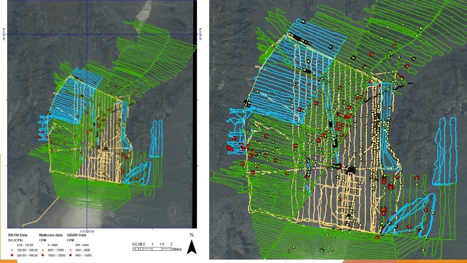
Target Area 63 -10 Surveillance The area has grown from the original 4 sq/mi to 29 sq/mi by 2012 (U. S. Army Environmental Policy Institue 1994) Surveys found DU spread outside the licensed area so the area had to be expanded to contain all the DU (Mc. Cumber, 2013). Most recent surveys show DU is still beyond the licensed area (Mc. Cumber, 2013). How far beyond is unclear. Air Force as stated further surveillance is necessary to determine the full extent of the DU contamination on 63 -10 (Mc. Cumber, 2013).
Drive over Surveillance Set-up Trimble Antenna Meter Probes
Target Area 63 -10 Surveillance Along with ground surveillance, some soil sampling was also conducted in primary drainage areas. No diffuse DU was found in those samples As more of the rounds on the range oxidize, this could change. Environmental impact report stated there was an annual clean-up done annually. Report stated 350 lbs of DU penetrators were collected in 2005. Each round weights. 66 lbs 350 lbs is approx. 530 rounds 7500 rounds are dropped every year, so only. 07% of rounds are picked up annually during “clean-up”. (U. S. Army Environmental Policy Institute 1994)
Oxidized DU Biggest concern is oxidized DU penetrators. Oxidized particles are what can get carried away with water run-off or mixed in the soil. Intact penetrators Oxidized penetrator (Miller, et al. 2016)
Remediation DU remediation is extremely costly Done either by chemical process called “Soil Washing” or by removing contamination with screening equipment and magnetic separator. Magnetic separator only effective for large pieces of DU Disposing of contaminated soil without performing some form of remediation first is approx. $1300 per cubic yard. Army Corp of Engineers recommends using mapping technology to identify localized DU contamination for remediation. (Walters, et al. 2014)
Going Forward with Further Characterization Further contamination characterization is needed but areas left to survey are impassible by foot or ATV. Research will be conducted to determine whether an Unmanned Aerial Vehicle (UAV) or Unmanned Ground Vehicle (UGV) are appropriate systems to continue contamination characterization. UAV/UGV must have capability autonomously following a programed path. Hydrological modeling will be done to further refine possible DU contaminated areas.
UAV • Left: Patria mini-UAV used during a study of Chernobyl accident site. • Successfully detected Cesium-137 flying at 43 mph (Toivonen, et al. 2009). • Top right: md-1000 UAV (Microdrone) • System in Germany built for radiation detection during emergency response operations (Bogatov, et al. 2013).
UAV Despite multiple examples of UAVs being used successfully for radiation detection still many factors to consider Most test were conducted using Cesium-137 which has very high activity UAV for DU detection would have to fly much lower and slower for successful detection Further research will be conducted to determine whethere is a UAV that is capable of flying at low altitude and be able to maneuver around type of quickly changing terrain at range 63 -10.
UGV Might be a more feasible option of the two unmanned vehicle types Military use increased from 12 systems in 2003 to 4000 system in 2007 (Nguyen-Huu and Titus 2009). Milrem and Leica Geosystems has produced the first UGV for off-road use in June 2016 (Business Wire 2016). Company will be contacted to get more details on just how “off road” it can go.
UAV and UGV Together UGV made by ETNAMATICA S. r. l and a “Hummingbird” quadcopter by Ascending Technology paired up. UGV is programed to follow a particular route autonomously If UGV came across a “difficult situation” the UAV could then be deployed from the UGV and the UAV would then continue to follow the same programed path while transmitting aerial images back to base. New route could then be planned for the UGV and UAV lands right back on UGV. (Cantelli, et al. n. d. )
Hydrological Analysis With the large amounts of DU on the range, potential water run-off is a concern for DU rounds that have oxidized. Other hydrological studies of DU have shown DU particles and oxides can migrate in water run-off. Hydrological Analysis will be conducted on the 63 -10 target area. Further research is needed to determine best software for the purpose of this project. Flo-2 D Waternet Arc. Gis Aquire a high quality DEM file of the area for the analysis. Poor quality will be difficult to get accurate modeling results. Soil type and annual precipitation will researched incorporated into modeling. DU density will considered during modeling (DU is a very heavy metal).
Timeline Aug-Oct: Conduct further research on UAV/UGV to determine if there is a feasible platform appropriate for surveying the remaining areas of 63 -10. Contact companies Set up demos if appropriate Ensure vehicle can be programed to act autonomously Aug-Sep: Compile all current survey data. Currently all data is in hundreds of separate files that need to combined into one data set. Sep-Nov: Test different hydrological analysis software for best results and perform hydrological analysis on data Flo-2 D Waternet Arc. Gis Nov: Present findings to United States School of Aerospace Medicine (USAFSAM), Dayton OH
Summary There has been a lot of data collected thus far at range 63 -10 but the site is not fully characterized. The Air Force needs to determine the best method to characterize areas that are not passible by foot/ATV. DU may have the potential to spread further outside the permitted area through water run-off, and that can be determined through hydrological modeling. Determining where DU is located will aid the Air Force in future remediation decisions.
References Business Wire. 2016. Milrem and Leica Geosystems Announce Pegasus: Multiscope: A New Unmanned Ground Vehicle for Surveying, Security, and Monitoring Applications. June 13. Accessed July 3, 2016. http: //www. businesswire. com/news/home/20160613005624/en/Milrem-Leica-Geosystems-Announce-Pegasus. Multiscope. Unmanned-Ground. Cantelli, L. , M. Lo Presti, M. Mangiameli, C. D. Melita, and G. Muscato. n. d. "Autonomous Cooperation Between UAV and UGV to Improve Navigation and Environmental Monitoring in Rough Environments. " Catania, Italy: University of Catania. Mc. Umber, Andrew. 2013. Summary Report of Depleted Uranium (DU) Survey Actions at Nevada Test and Training Range (NTTR), Airspace Region 63 B, Active Target Complex 10 (63 -10). Consultative Letter, Wright-Patterson AFB, OH: USAF School of Aerospace Medicine. Miller, Julianne, David Shafer, Charalambos Papelis, Craig Refosco, and Nathan Kryzaniak. 2016. "High Density Metal Contamination Transport in Arid Region Ephemeral Channels. " In Military Geosciences and Desert Warfare, by E V Mc. Donald, 139 -151. New York: Springer Science+Business Media Nguyen-Huu, Phuoc-Nguyen, and Joshua Titus. 2009. Reliability and Failure in Unmanned. Technical Report, Ann Arbor, MI: University of Michigan Ground Robotics Research Center. United States Air Force. 2006. "Environmental Assessment for Increased Depleted Uranium Use on Target 63 -10, Nevada Test and Training Range. " Environmental Assessment Walters, Joseph, Jarrett Mackey, Kahlan Maki, Raymond Northcutt, John V Farr, Andy W Martin, Steven L Larson, John H Ballard, and Catherine Nestler. 2014. Cost Analysis of Remediation Systems for Depleted Uranium. Environmental Quality/Installations Research and Development Program Center for Nation Reconstruction and Capacity Development.
QUESTIONS?