AIR PRESSURE AIR MASSES AND FRONTS Earth Science


- Slides: 24
AIR PRESSURE, AIR MASSES AND FRONTS Earth Science
Air Pressure � Air Pressure: The weight of the air pushing down on the surface of earth. Barometer: • The tool that measures air pressure.
High and Low Pressure Systems � High pressure is caused by Cool, Dry air SINKING. � Low pressure is caused by Warm, Moist air RISING. � Cool, Dry Air = High Pressure � = Clear Skies � � Warm, �= Moist Air Low Pressure �= Cloudy Skies
ISOTHERMS Isotherms: Lines connecting place of equal temperature
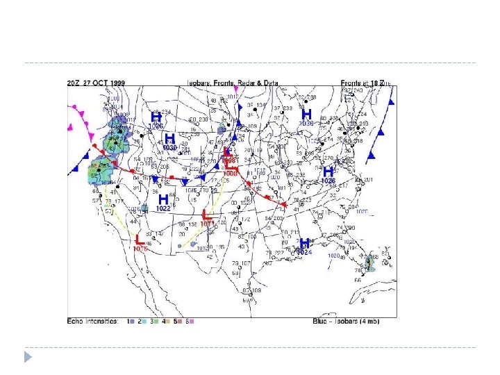
Pressure Centers � Isobars: Lines on a map connecting places with equal pressure. This shows you the area of High and Low Pressure. � Arrows show direction of wind.
DRAWING ISOBARS • 000 •
Global Winds � Global Winds: the global circulation of air from HIGH pressure to LOW pressure. � THE WINDS WILL BLOW FROM HIGH TO LOW � The winds would go either North or South except for the Coriolis Effect causes the wind to curve to the RIGHT � What Global Winds affect North America? Prevailing Westerlies
Coriolis Effect � The apparent curve of the wind to the right in the Northern Hemisphere. � Caused by Earth’s Rotation � http: //www. wiley. com/college/strahler/0471480533/animations/c h 07_animations/animation 2. html
Pressure Systems � Surface winds: � High = Move OUT of the center � Low = Move IN toward the center � Add the Coriolis effect (curve to the right) Motion around a High = Clockwise Motion around a Low = Counter Clockwise Anti. Cyclone
AIR MASSES � Air Mass: A large volume of air defined by its TEMPERATURE and WATER VAPOR. �c = Continental = Dry � m = Maritime = Moist � P = Polar = Cold � T = Tropical = Warm � c. P = Continental Polar air =Cold, Dry air from Canada � m. P = Maritime Polar air = Cold, Moist air from N. Atlantic Warm, Dry air from Mexico � c. T = Continental Tropical = � m. T = Maritime Tropical = Warm, Moist air from Gulf of Mexico
Frontal Boundaries � Frontal Boundary = Where two different air masses collide. � Cool, Dry air collides with Warm, Moist air.
Cold Front � Cold Front = Where a c. P air mass collides with a m. T air mass. � c. P air is doing the pushing. � m. T air is rising UP creating vertical clouds. � Cumulonimbus clouds � Thunderstorm What is the weather at A? � What is the weather at B? � What is the weather at C? � C B A
Warm Front � Warm Front = When a m. T air mass collides with a c. P air mass. � m. T air mass is doing the pushing. � As m. T air pushes, it rises over the c. P air creating low horizontal clouds. � Stratus, nimbostratus, cirrus What is the weather at A? � What is the weather at B? � What is the weather at C? � C B A
Weather Map Symbols � Identify the weather map symbols to determine weather in your area. � Cold Front = � Warm Front = c. P m. T
Weather Forecasting c. P NW m. T S W
Current U. S. Weather Map � May 24, 2011
Friday’s Weather Map m. P m. T
Mid-Latitude Cyclone
Hurricanes � 3 things needed to form a hurricane � Low Pressure � Warm ocean temperatures � High humidity
Hurricane � Where are hurricanes located when at their strongest? � Winds over 76 mph
Hurricanes � What happens when the hurricane hits land?
Weather Station Model � Used to deliver a lot of information in a small space
Weather Map