A Pilots Perspective of Weather Daniel Stewart Outline





- Slides: 36

A Pilot’s Perspective of Weather Daniel Stewart

Outline • • Personal History Weather at the Briefing Weather for Pre-Takeoff & Climb Weather Enroute Weather for the Descent & Approach Extreme Weather Q&A

Personal History • • Name: Daniel Stewart Company: EVA AIR Job Description: First Officer MD 11 Fleet Licences: Taiwan CAA ATPL USA FAA ATP Australian CASA ATPL • Academic Qualification: B. Com(HONS)

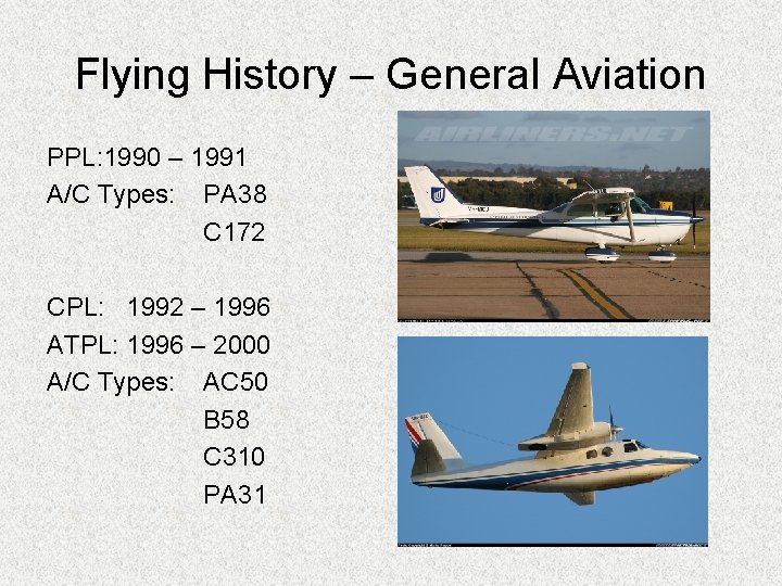
Flying History – General Aviation PPL: 1990 – 1991 A/C Types: PA 38 C 172 CPL: 1992 – 1996 ATPL: 1996 – 2000 A/C Types: AC 50 B 58 C 310 PA 31

General Aviation - Aeroplanes

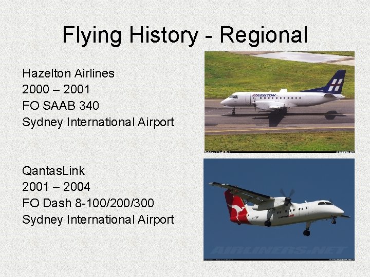
Flying History - Regional Hazelton Airlines 2000 – 2001 FO SAAB 340 Sydney International Airport Qantas. Link 2001 – 2004 FO Dash 8 -100/200/300 Sydney International Airport

Flying History - Airlines EVA AIR 2004 – FO MD 11 Fleet

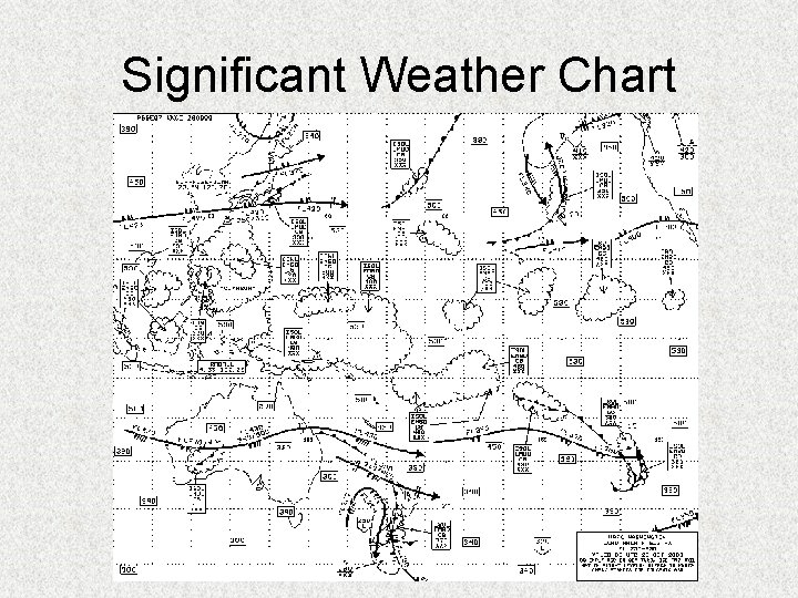
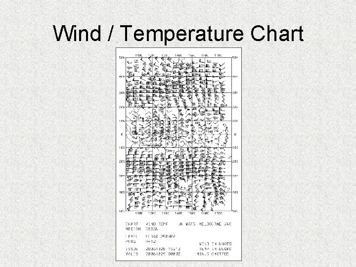
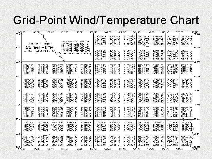
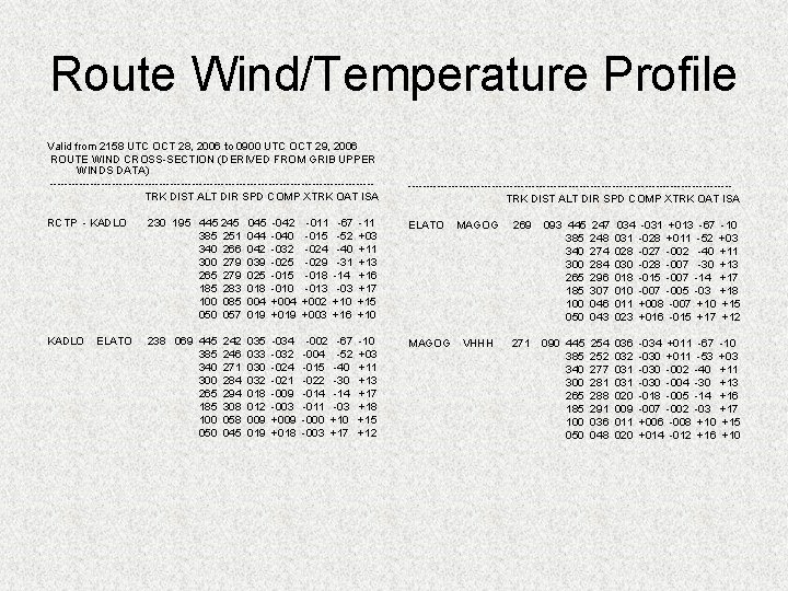
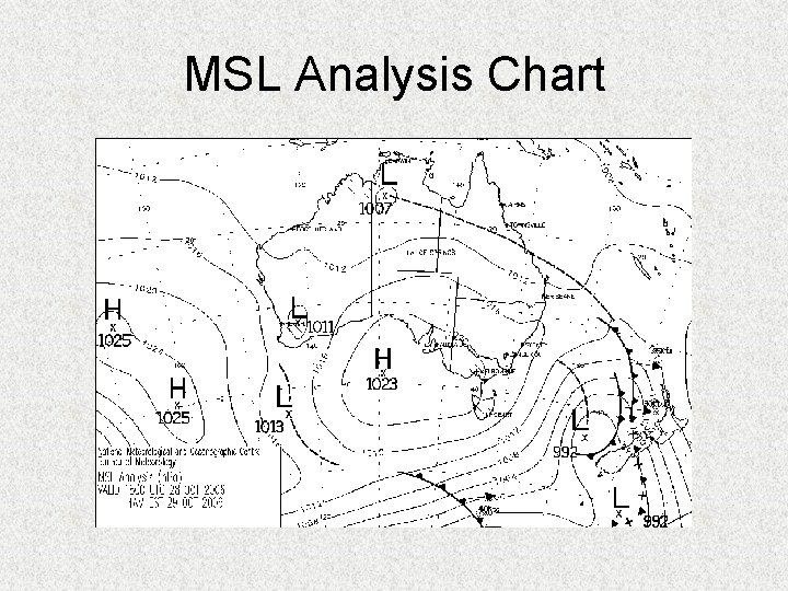
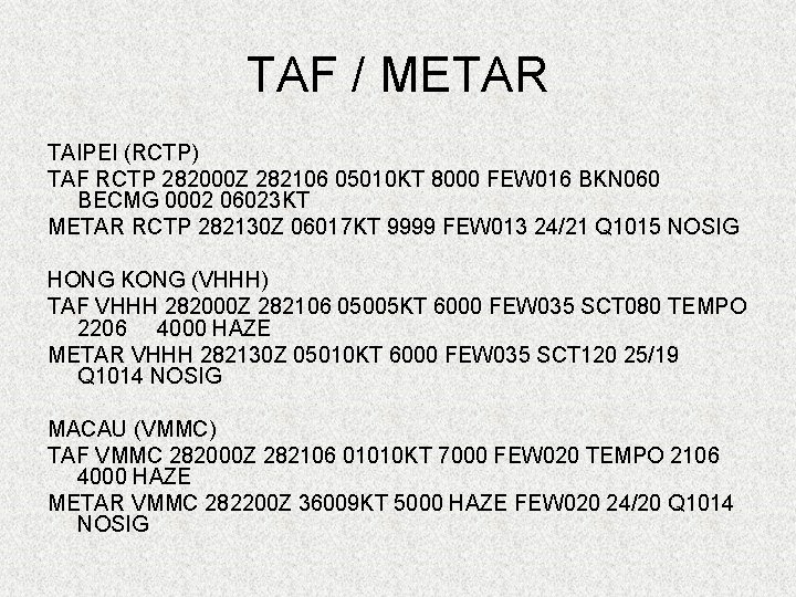
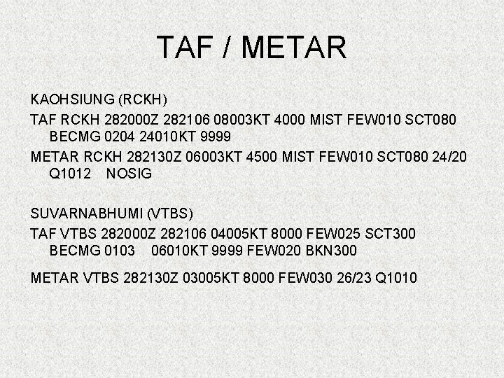
Weather at the Briefing • • Significant Weather Chart SIGMET Wind/Temperature Chart Grid-point Wind/Temp Chart Route Wind/Temp Profile MSL Analysis Chart TAF/METAR

Significant Weather Chart

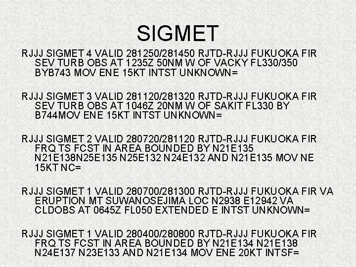
SIGMET RJJJ SIGMET 4 VALID 281250/281450 RJTD-RJJJ FUKUOKA FIR SEV TURB OBS AT 1235 Z 50 NM W OF VACKY FL 330/350 BYB 743 MOV ENE 15 KT INTST UNKNOWN= RJJJ SIGMET 3 VALID 281120/281320 RJTD-RJJJ FUKUOKA FIR SEV TURB OBS AT 1046 Z 20 NM W OF SAKIT FL 330 BY B 744 MOV ENE 15 KT INTST UNKNOWN= RJJJ SIGMET 2 VALID 280720/281120 RJTD-RJJJ FUKUOKA FIR FRQ TS FCST IN AREA BOUNDED BY N 21 E 135 N 21 E 138 N 25 E 135 N 25 E 132 N 24 E 132 AND N 21 E 135 MOV NE 15 KT NC= RJJJ SIGMET 1 VALID 280700/281300 RJTD-RJJJ FUKUOKA FIR VA ERUPTION MT SUWANOSEJIMA LOC N 2938 E 12942 VA CLDOBS AT 0645 Z FL 050 EXTENDED E INTST UNKNOWN= RJJJ SIGMET 1 VALID 280400/280800 RJTD-RJJJ FUKUOKA FIR FRQ TS FCST IN AREA BOUNDED BY N 21 E 134 N 21 E 138 N 24 E 137 N 23 E 133 AND N 21 E 134 MOV ENE 20 KT INTSF=

Wind / Temperature Chart

Grid-Point Wind/Temperature Chart

Route Wind/Temperature Profile Valid from 2158 UTC OCT 28, 2006 to 0900 UTC OCT 29, 2006 ROUTE WIND CROSS-SECTION (DERIVED FROM GRIB UPPER WINDS DATA) ----------------------------------------------------------------------------------------TRK DIST ALT DIR SPD COMP XTRK OAT ISA RCTP - KADLO 230 195 445 245 385 251 340 266 300 279 265 279 185 283 100 085 050 057 045 044 042 039 025 018 004 019 -042 -040 -032 -025 -010 +004 +019 -011 -015 -024 -029 -018 -013 +002 +003 -67 -52 -40 -31 -14 -03 +10 +16 -11 +03 +11 +13 +16 +17 +15 +10 ELATO MAGOG 269 093 445 385 340 300 265 185 100 050 247 248 274 284 296 307 046 043 034 031 028 030 018 010 011 023 -031 -028 -027 -028 -015 -007 +008 +016 +013 -67 +011 -52 -002 -40 -007 -30 -007 -14 -005 -03 -007 +10 -015 +17 -10 +03 +11 +13 +17 +18 +15 +12 KADLO 238 069 445 385 340 300 265 185 100 050 035 033 030 032 018 012 009 019 -034 -032 -024 -021 -009 -003 +009 +018 -002 -67 -004 -52 -015 -40 -022 -30 -014 -011 -03 -000 +10 -003 +17 -10 +03 +11 +13 +17 +18 +15 +12 MAGOG VHHH 271 090 445 385 340 300 265 185 100 050 254 252 277 281 288 291 036 048 036 032 031 020 009 011 020 -034 -030 -018 -007 +006 +014 +011 -67 +011 -53 -002 -40 -004 -30 -005 -14 -002 -03 -008 +10 -012 +16 -10 +03 +11 +13 +16 +17 +15 +10 ELATO 242 246 271 284 294 308 058 045

MSL Analysis Chart

TAF / METAR TAIPEI (RCTP) TAF RCTP 282000 Z 282106 05010 KT 8000 FEW 016 BKN 060 BECMG 0002 06023 KT METAR RCTP 282130 Z 06017 KT 9999 FEW 013 24/21 Q 1015 NOSIG HONG KONG (VHHH) TAF VHHH 282000 Z 282106 05005 KT 6000 FEW 035 SCT 080 TEMPO 2206 4000 HAZE METAR VHHH 282130 Z 05010 KT 6000 FEW 035 SCT 120 25/19 Q 1014 NOSIG MACAU (VMMC) TAF VMMC 282000 Z 282106 01010 KT 7000 FEW 020 TEMPO 2106 4000 HAZE METAR VMMC 282200 Z 36009 KT 5000 HAZE FEW 020 24/20 Q 1014 NOSIG

TAF / METAR KAOHSIUNG (RCKH) TAF RCKH 282000 Z 282106 08003 KT 4000 MIST FEW 010 SCT 080 BECMG 0204 24010 KT 9999 METAR RCKH 282130 Z 06003 KT 4500 MIST FEW 010 SCT 080 24/20 Q 1012 NOSIG SUVARNABHUMI (VTBS) TAF VTBS 282000 Z 282106 04005 KT 8000 FEW 025 SCT 300 BECMG 0103 06010 KT 9999 FEW 020 BKN 300 METAR VTBS 282130 Z 03005 KT 8000 FEW 030 26/23 Q 1010

Weather for Take-Off & Climb • a) b) c) d) e) f) Upon arrival at airport/during pre-flight inspection – Observe the weather. Wind direction and speed, Cloud – amount, base, & type. Precipitation – amount, type, & location. Temperature & humidity. RWY/TWY condition (wet/ice/snow) Other phenomena (dust devils/virga/etc).

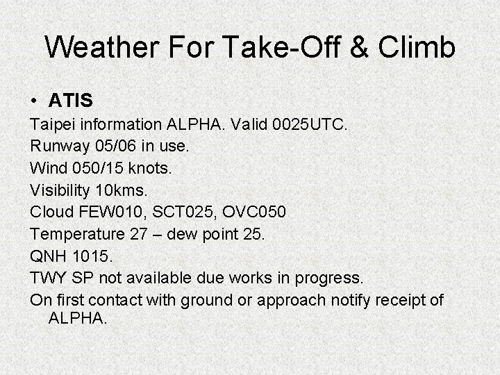
Weather For Take-Off & Climb • ATIS Taipei information ALPHA. Valid 0025 UTC. Runway 05/06 in use. Wind 050/15 knots. Visibility 10 kms. Cloud FEW 010, SCT 025, OVC 050 Temperature 27 – dew point 25. QNH 1015. TWY SP not available due works in progress. On first contact with ground or approach notify receipt of ALPHA.

Differences between personal observation & ATIS • • • a) b) c) d) • “Smell the weather”. Observe what is happening. Anticipate probable changes: Wind shifts. Commencement/cessation of precipitation. Temperature. RWY condition. ATIS is only an observation of what has happened, NOT a forecast. Therefore it can change prior to take-off.

Things to consider for take-off • RWY Condition – Dry, Damp, Wet, Icy, & Snow for aircraft performance. • Wind – Crosswind & downwind limitations. Headwind or downwind component for aircraft performance. • Visibility – Low visibility procedures. Departure alternate requirements.

Things to consider for take-off • Cloud – TCU/CB. Icing conditions. • Temperature – Icing conditions. Aircraft performance. • Precipitation – Rain, hail, snow, & fog. Reduced visibility, damage to aircraft, icing conditions. • Other phenomena – Windshear, dust devils, & tornadoes. Aircraft performance.

Use of Weather Radar • • Conduct preflight test. Turn on prior to lineup. Adjust tilt to remove ground returns. Observe weather on take-off/climb path. Great for - Rain, wet hail, etc. NOT for – Windshear, CAT, dry hail, etc. Don’t forget to “look out the window”.

Weather Enroute – SIGWX Chart • a) b) c) d) e) f) g) Accuracy of position, levels & severity of CAT, Thunderstorms, Typhoons, Volcanic Ash, Cold/Warm Fronts, Jetstreams, and Level of Tropopause.

Weather Enroute – Wind/Temperature • Accuracy of wind/temperature forecasts. • Temperature affects TAS/MACH • Wind affects ground speed & drift angle.

Weather Enroute – Obtaining Updates Inflight • VOLMET (Volume Meteorological) – HF/VHF • AERIS (Automatic En Route Information Service) - VHF • ACARS (Aircraft Communication and Reporting System) – VHF/Satellite

Weather for Descent & Approach • a) b) c) 1. Very similar considerations as take-off & climb: Obtain ATIS, Use of radar, and Own observation from cockpit. However, there is a heavier reliance on points a) & b) particularly at night and/or when in Instrument Meteorological Conditions (IMC).

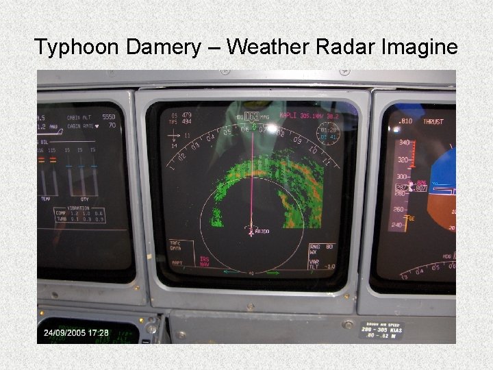
Extreme Weather - Tropical • a) b) c) d) Typhoon/Cyclone/Hurricane Warnings Timely, Accurate in forecasting movements, Level of severity (Category 1 – 5), and Easy to understand.

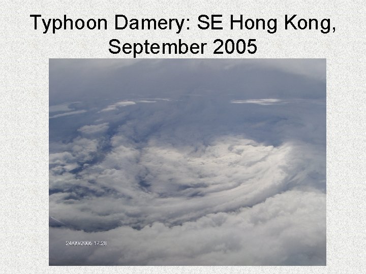
Typhoon Damery: SE Hong Kong, September 2005

Typhoon Damery – Weather Radar Imagine

Tropical Thunderstorms • • • Very high vertical development Very heavy rain Reduced visibility Lots of thunder and lightning Low cloud base Not as serve turbulence as other mid & high latitude thunderstorms. But still treat with plenty of respect!!

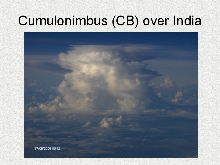
Cumulonimbus (CB) over India

Desert Regions • Extreme heat, particularly on the tarmac: a) Loss of aircraft performance, b) Ambient temperature may exceed limits for APU/engine start, • Dust storms & dust devils, • High base thunderstorms, • Windshear, • Reduction in personal comfort and performance.

Mid-Latitude Weather • Cold fronts, • Warm fronts, • Fog, • Powerful & serve thunderstorms with hail, and • Tornadoes (particularly in Southern USA),

Artic Region Weather • Icing conditions: a) Slippery RWY/TWYs, dangerous & difficult to control/stop aircraft. b) Snow/slush covered RWY/TWYs, reduced take -off performance and possible freezing of flight controls. c) De/Anti-Icing procedures

Artic Region Weather d) De/Anti-Icing inflight: i) Jet Aircraft – Better systems, - Less exposure to icing conditions. ii) Prop Aircraft – Limited systems, - Longer exposure to icing conditions. May not be able to climb/descend out of icing conditions.

Thank-You