WIGOS Data Quality Monitoring System WDQMS Demonstration project
 Demonstration project in RA I The Plan, Status")
 Monitoring tools Incident Management tools/procedures Phases and")
 Background: • Outcome of 2 nd WIGOS Workshop on Quality Monitoring and")
 Participants: i) Kenya Meteorological Department (KMD) - operations pilot centre, providing temporary")


 Website: - 1 st prototype developed at")

 Land surface silent stations and 2) Data availability")

 of incidents •")

 Initial WIGOS (land")

- Slides: 16
WIGOS Data Quality Monitoring System (WDQMS) Demonstration project in RA I The Plan, Status and First Results Luis Nunes WIGOS Project Office
Outline • • Rationale (objectives, participants, timeframe) Monitoring tools Incident Management tools/procedures Phases and their status 1) 2) 3) 4) Land surface silent stations 1) + availability of land surface stations 1)+2) + accuracy of pressure observations 1)+2)+3) + radiosonde stations accuracy and availability • First results • Next Steps
Rationale (1) Background: • Outcome of 2 nd WIGOS Workshop on Quality Monitoring and Incident Management (Geneva, Switzerland December 2015) Goal: • Test the concept of the WIGOS Data Quality Monitoring System (WDQMS) and its major components: – the monitoring function (QM) for data availability and data quality, – the analysis and evaluation function (Ev), – the incident management function (IM) Steps: A. Planning and preparation of the Demonstration Project in RA I: Jan-May 2016; B. Running/testing the QM/Ev/IM functions in operational environment: Jun-Nov 2016; C. Assessment via a dedicated Workshop and follow-up actions: December 2016
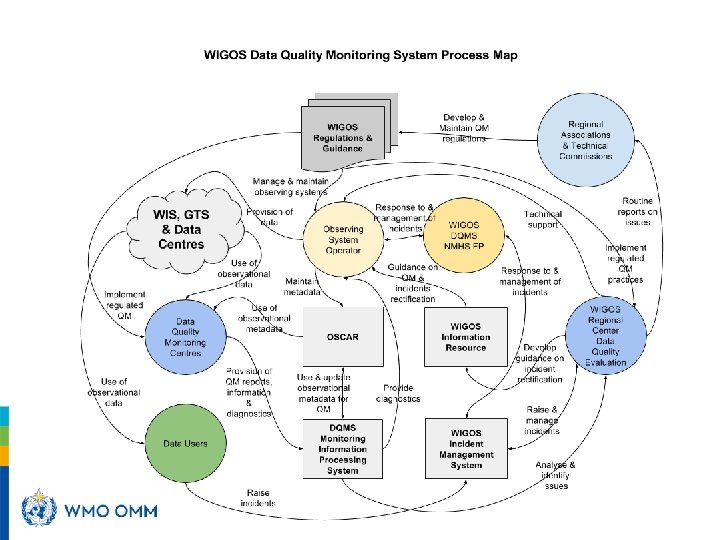
Rationale (2) Participants: i) Kenya Meteorological Department (KMD) - operations pilot centre, providing temporary local resources (human and technical); ii) Tanzania and possibly other WMO Members (English speaking Countries); iii) NWP Centres (ECMWF, NCEP, JMA) providing monitoring results in near real time; - Additionally: EUMETNET Governance: - ICG-WIGOS Task Team on WDQMS providing technical advice and support; - WIGOS Project Office (WMO Secretariat), providing support to participants and training in OSCAR/Surface; Tools to be made available by TT-WDQMS and WMO Secretariat: a) an online monitoring information/processing system, with geographic visualization tools b) an incident management tracking tool; Other tools/resources: • OSCAR/Surface operational and populated
Demonstration Project
Monitoring tools WIGOS Quality Monitoring Web-tool: - 1 st prototype developed at WMO Secretariat in collaboration with TT-WDQMS: - for daily quality monitoring and evaluation -> http: //128. 65. 196. 37/wdqms ECWMF Wiki page ‘Demonstration Project’: - to identify silent stations (missing in the quality reports of ECMWF, NCEP and JMA, referring to a 24 -h coverage) -> https: //software. ecmwf. int/wiki/display/WIGOS/Demonstration+Project WMO Quality Monitoring Portal operated by EUMETNET - to identify silent stations or stations providing less data than required, - and stations showing large accuracy errors of pressure according to ECMWF O-B results -> https: //eucos. dwd. de/ravi OSCAR/Surface - to identify (non-)compliance in station metadata information -> https: //oscar. wmo. int/OSCAR
Incident Management Tools/Procedures Based on a (Google) Website: - 1 st prototype developed at WMO Secretariat in collaboration with TT-WDQMS: - for raising, communicating and following incidents -> https: //sites. google. com/a/wmo. int/wdqms-demo-ra-i/home It contains relevant information about the ‘Demonstration Project’: - contacts of people involved, - links to the monitoring tools, - procedures to be followed by participating countries - guidance for the procedures and how to use the website - links to each incident ticket - repository and summary of incident tickets for each country, - everybody involved receives automatic notifications of new tickets created or updates/edits to existing tickets
Phases Phase 1 = Land surface silent stations Phase 2 = phase 1 + availability of land surface stations Phase 3 = phases 1 & 2 + accuracy of pressure observations Phase 4 = phase 1, 2 & 3 + radiosonde stations accuracy & availability
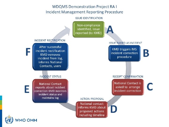
Status of phases 1, 2 1) Land surface silent stations and 2) Data availability of land surface stations • Total of 32 incident tickets have been raised by KMD: – 21 tickets for KMD stations • 12 tickets have been closed (although 5 are recorded as such in the summary), • 9 tickets have no follow-up; – 11 tickets for TMA stations • 1 ticket has been closed, • 10 tickets have no follow-up • All 32 incidents refer to silent stations or data availability • Inconsistencies between the tickets and the summaries
Findings from phases 1, 2 • Technical problems: – Editing the website and/or the tickets • Functional problems: – Initial lack of a national contact for KMD for the follow-up of the incidents, in addition to the person in charge of the monitoring – (Is there the need for a "System Coordinator"? ) • Other problems: – Update of OSCAR/Surface
Provisional conclusions • The IM system should create/update automatically the summary(ies) of incidents • Training is essential: – for the use of a IMS (the Google-site in this case) – OSCAR/Surface, particularly for National Focal Points • Technical support (IT) is essential to ensure operations of a IMS • The IMS must be robust and based on standard technology and compatible with current HW/SW existing in the market
Next Steps • Phases 3 and 4 of the Demonstration project will follow: – Training session for monitoring accuracy of pressure observations: mid September – Training session for monitoring of radiosonde stations accuracy and availability: mid October – End of Demonstration project: late November 2016 • A TT-WDQMS Meeting/3 rd Workshop: December, 13 -15 planned • Results to be submitted to ICG-WIGOS: January/February 2017
Next Steps • The Plan for the WIGOS Pre-Operational Phase: (a) Initial WIGOS (land surface stations of the GOS) monitoring capability at ECMWF, NCEP and/or other NWP centres, evaluation and incident management functions by end of 2016; (b) Functional specifications and the pilot components developed, following demonstration project: end 2016; (c) Full WIGOS (GOS surface-based components) operational QM & IM functionality: end of 2018; (d) Monitoring Workshop(s) for JCOMMOPS, GAW, GCOS, GCW and hydrology components of WIGOS: 2016 -17; (e) Initial monitoring capability for all WIGOS components by end of 2018; (f) Mechanisms for routine reporting of monitoring results to EC, regional associations and Members: end 2017; (g) Mechanisms and regional structures in place to handle incident management actions and support Members in improving the data availability and quality by 2018 (dependent on establishment of RWCs).
Thank you lfnunes@wmo. int www. wmo. int/wigos