UNIT1 Introduction to Hydrogeology What is Hydrogeology Hydrogeology


of the Hydrologic Cycle � Evapotranspiration (Evaporation + Transpiration) is water evaporating from")
 of the Hydrologic Cycle � Precipitation - is water being released from")


 that")


 � Water recharged or discharged from an aquifer represents")

 versus Storage Coefficient (Confined Aquifer)")
, permeability is")

- Slides: 45
UNIT-1 Introduction to Hydrogeology
What is Hydrogeology �Hydrogeology (hydro- meaning water, and - geology meaning the study of the Earth) is the area of geology that deals with the distribution and movement of groundwater in the soil and rocks of the Earth's crust (commonly in aquifers). �The terms groundwater hydrology, geohydrology, and hydrogeology are often used interchangeably.
Introduction � Groundwater resource. is one of the most precious natural � It is the most important source of drinking water and supplies water for irrigation, agricultural and domestic usage. � Of the total water available on earth, less than 2. 5 % is fresh water of which 68. 7% is found in the ice caps and glaciers (frozen state). � Approximately 30% is groundwater and less than 1. 2% is surface water (lakes, streams, permafrost, soil moisture etc. )
Distribution of Water on Earth
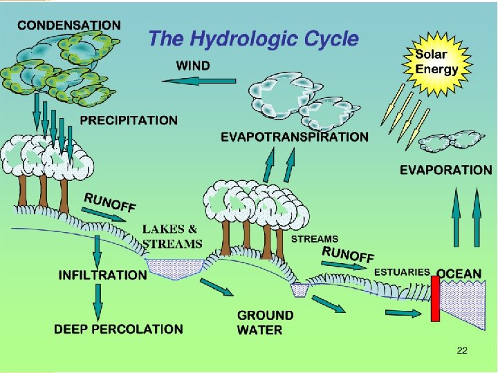
The Hydrologic Cycle � The hydrologic cycle explains the exchange of water between the atmosphere, lithosphere and the hydrosphere. � It depicts how part of the ocean water evaporates, the water vapour turns into fresh water precipitation (rain, hail, snow) on the earth’s surface (seas, land), then flows over the land surface (glaciers, runoff, streams) and partly infiltrates into the soil (soil water) to be used by the vegetation (evapotranspiration), or to recharge the groundwater bodies. � The water on the Earth's surface--surface water--occurs as streams, lakes, and wetlands, as well as bays and oceans. � Surface water also includes the solid forms of water-- snow and ice. � The water below the surface of the Earth primarily is ground water, but it also includes soil water. � The movement of water through the cycle annually replenishes our water supplies, thus making water a renewable resource.
Components (parts)of the Hydrologic Cycle � Evapotranspiration (Evaporation + Transpiration) is water evaporating from the ground and transpiration by plants. � Evapotranspiration the atmosphere. � Condensation to a liquid. � Water is also the way that water vapor re-enters - is the process of water changing from a vapor in the air rises mostly by convection. � This means that warm, humid air will rise, while cooler air will flow downward. � As the warmer air rises, the water vapor will lose energy, causing its temperature to drop. The water vapor then has a change of state into liquid or ice.
Components (parts) of the Hydrologic Cycle � Precipitation - is water being released from clouds as rain, sleet, snow or hail. � Precipitation begins after water vapor, which has condensed in the atmosphere, becomes too heavy to remain in atmospheric air currents and falls. � Infiltration - when a portion of the precipitation that reaches the Earth's surface seeps into the ground. � Percolation - is the downward movement of water through soil and rock. � Percolation occurs beneath the root zone. � Runoff - is precipitation that reaches the surface of the Earth but does not infiltrate the soil. Runoff can also come from melted snow and ice.
Division of sub surface water � A portion of the water infiltrates the soil and is know as the subsurface water but not all the water percolates down the water table to be termed as groundwater. � Three things can basically happened when water enters the ground. � 1) water may be pulled back to the surface by the capillary forces and evaporate to the atmosphere. � 2) it can be absorbed by the plant roots present in the soil and then re-enter the atmosphere by transpiration and � 3) some water which may have percolated deep enough can be pulled downwards by the forces of gravity until it reaches the zone of saturation and becomes a part of the groundwater reservoir that supplies water to wells.
Division of sub surface water �In terms of hydrogeology, the underground soil water is classified in to two basic zones: - �a) Zone of Aeration �b) Zone of Saturation
Zone of Aeration - Vadose Zone � Zone of Aeration, also termed as Vadose zone or unsaturated zone, is that portion of sub-soil in which pores are filled partially with air and partially with water. � The word Vadose is derived from Latin meaning Shallow. � Vadose zones extends from the Earth’s surface to the top of the saturated zone. � The soil and rock in the vadose zone are not fully saturated with water; that is, the pores within them contain air as well as water. � In some places the vadose zone is absent, as is common where there are lakes and marshes, and in some places it is hundreds of meters thick, as is common in arid regions.
Zone of Aeration - Vadose Zone � The water present in vadose zone is at or below atmospheric pressure. The unsaturated, vedose or aeration zone is further classified into three sub zones: - � A) Soil – water Zone: This begins at the ground surface and extends downward through the major root zone. Its total depth is variable and dependent upon soil type and vegetation. � B) Intermediate Zone: This zone extends from the bottom of the soil-water zone to the top of the capillary fringe and may vary from nonexistence to several hundred feet in thickness. The zone is essentially a connecting link between the near-ground-surface region and the near-water-table region, through which infiltrating waters must pass. � C) Capillary Zone: This zone extends from the water table to a height determined by the capillary rise that can be generated in the soil. The capillary-zone thickness is a function of soil texture and may vary not only from region to region but also within a local area.
Zone of Saturation - Pheratic Zone � Zone of Saturation, also termed as Pheratic zone, is the one in which all the pore spaces in the soil/rocks are completely saturated and filled with water under hydrostatic pressure. � The upper limit of this zone of saturation is termed as the water table. � The water table, is a very significant feature of the groundwater system. � The water-table level is important in predicting the productivity of wells, explaining the changes in the flow of springs and streams, and accounting for fluctuations in the levels of lakes.
Non Saturated and Saturated zones
Variations in the Water Table � The depth of the water table is highly variable and can range from zero, when it is at the surface, to hundreds of meters in some places. � An important characteristic of the water table is that its configuration varies seasonally and from year to year because the addition of water to the groundwater system is closely related to the quantity, distribution, and timing of precipitation. � Except where the water table is at the surface, we cannot observe it directly. � Nevertheless, its elevation can be mapped and studied in detail where wells are numerous, because the water level in wells coincides with the water table.
Interaction between Groundwater and Streams � The interaction between the groundwater system and streams is a basic link in the hydrologic cycle. � It can take place in one of three ways. � 1) Streams may gain water from the inflow of groundwater through the streambed. Such streams are called gaining streams. � For this to occur, the elevation of the water table must be higher than the level of the surface of the stream. � 2)Streams may lose water to the groundwater system by outflow through the streambed. The term losing stream is applied to this situation � When this happens, the elevation of the water table is lower than the surface of the stream. Losing streams can be connected or disconnected � 3) The third possibility is a combination of the first two—a stream gains in some sections and loses in others.
Interaction between Groundwater and Streams
Origin and age of groundwater � Almost all groundwater is a part of the hydrologic cylce, including surface and atmospheric waters. � However minor amount of groundwater may be derived from other origins. � Water that has been out of contact with atmosphere for an appreciable part of geologic period is termed as connate water. This water may have been derived from ocean or fresh water sources and is highly mineralized. � Magmatic water is derived from magma. Where the separation is deep, it is known as plutonic water, while volcanic water indicates water from relatively shallow depths.
Origin and age of groundwater � New water of magmatic or cosmic origin that has not previously been a part of the hydrosphere is referred to as juvenile water. � Metamorphic water is the water that has been associated with the rocks during their metamorphism. � Radioactive isotopes are helpful in determining the age of groundwater. � Two most useful radioactive isotopes for determining the age of water are Hydrogen-3 (Tritium) and Carbon-14. � Tritium (half life-12. 33 years) is used for estimating groundwater ages upto 50 years. � Whereas Carbon-14 (half life-5730 years) is used for dating groundwater ranging from a few hundred years to about 50, 000 years.
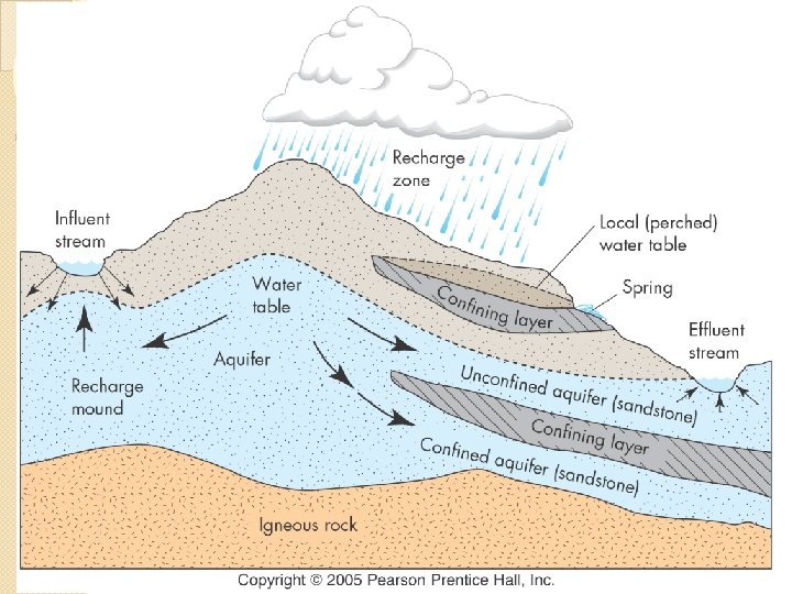
Water Bearing Formations �An aquifer is often described as a sub-surface geologic formation(s) that is porous (store water) as well as permeable (transmit water) and can yield sufficient quantities of water to wells and springs. �They have the ability to store as well as transmit water. E. g. : unconsolidated sand gravel �The word aquifer comes from the Latin words, "Aqua" (water), and "fer" (to carry). �In some cases, aquifers are vertically separated from each other by geologic formations that permit little or no water to flow in or out.
Water Bearing Formations �Aquitard is a saturated but poorly permeable geologic formation that restricts groundwater movement and does not yield water freely to wells. Example is SANDY CLAY �If the water barrier is almost impermeable (Example is CLAY ) and forms a formidable flow barrier between aquifers, it is known as a aquiclude �An aquifuge is geologic formation which has no interconnected openings (impermeable) and hence cannot absorb or transmit water. Example are Igneous and metamorphic rocks. E. g. : Granite
Types of Aquifer � Aquifers � An can be of two major types: unconfined or confined. unconfined aquifer has no overlying aquitard or aquiclude. � Where there are multiple levels of aquifers, the uppermost aquifer typically is unconfined. � Vertical recharge of an unconfined aquifer by rainwater or irrigation water that filters downward through the soil is not restricted. � The water table at the top of the unconfined aquifer can migrate freely up and down within the sediment formation, depending on how much water is stored there. � The water level in a borehole drilled into an unconfined aquifer will be at the same depth as the water table in the aquifer.
Types of Aquifer
Types of Aquifer � A confined aquifer, on the other hand, is sandwiched between an aquitard above and an aquiclude or aquitard below. � Because the water table in the recharge area of the confined aquifer is much higher than the top of the confined aquifer itself, water in a confined aquifer is pressurized. � This pressurization means that the water level in a borehole drilled into a confined aquifer will rise significantly above the top of the aquifer. � This level to which the water will rise if a well is drilled in a confined aquifer is known as the potentiometric surface. � A flowing artesian well occurs where the pressure is so high that the water level in a well drilled into the confined aquifer rises above the land surface — in other words, an open well flows freely with no pumping.
Types of Aquifer
Types of Aquifer � Sometimes the term semi-confined aquifer is used if an aquifer acts partly like a confined aquifer and partly like an unconfined aquifer. � Springs form where the water table intersects with the land surface: for example, in a small depression. � Sometimes ground water is forced into a spring because a low permeable layer of rock or fine sediments (clay) keeps the water from percolating deeper. � A spring may also occur where subsurface pressure forces water to the surface through a fracture or fault zone that acts as a conduit for water movement from a confined aquifer.
Types of Aquifer Anisotropy and heterogeneity � Most well hydraulics equations are based on the assumption that aquifers and aquitards are homogeneous and isotropic. � A homogeneous isotropic aquifers has the same hydraulic conductivity throughout the geological formation and is the same in all directions. � The individual particles of a geological formation, however, are seldom spherical so that, when deposited under water, they tend to settle on their flat sides. � Such a formation. can still be homogeneous, but its hydraulic conductivity in horizontal direction, K, , will be significantly greater than its hydraulic conductivity in vertical direction, K. This phenomenon is called anisotropy.
Types of Aquifer Anisotropy and heterogeneity � The lithology of most geological formations tends to vary significantly, both horizontally and vertically. This phenomenon is known as heterogeneity. � Anisotropy is a common property of fractured rocks. The hydraulic conductivity in the direction of the main fractures is usually significantly greater than that normal to those fractures
Aquifer Properties � Water in saturated zones and aquifers does not stay still. It can move further downward or it can flow horizontally through the saturated zone. � There are many factors that influence this water movement underground and the quantity of water stored in these various zones. � The main factor is the amount of space available between particles, sediments, and rocks in the soil layers and spaces between particles in rocks and rock layers.
Aquifer Properties � The empty spaces in between the crystals or fragments that make up a rock represent porosity that can hold water. � Porosity is a measure of how much water a rock can hold, but it is not necessarily a measure of how much water an aquifer can yield or produce. � Material with good porosity can be called “porous”. � Mathematically, porosity can be expressed as the ratio of the volume of pore space to the total volume of the material as given by the following formula:
Aquifer Properties � Porosity depends on the � size, � shape, � packing, � mixture of grains and particles, � presence of cementing material, � over burden stress and the presence of vugs and fractures present in soil or rocks • For instance, small particles such as clays are able to compact more closely together, reducing the amount of porosity. � • However, larger particles such as sand gravel will have more spaces available between them. • Round particles compacted together will have more spaces than elongated grains that stack more tightly.
Aquifer Properties � Particle packing affects the porosity. In general cubic packing of particles has a porosity of around 47. 6 % as compared to Rhombohedral packing where the porosity is about 26 %. � Particles of uniform size (well sorted) will also have more pore space available than grains of varying sizes (poorly sorted) because small particles can fill in the spaces between the larger grains. � Porosity can change between various layers of soil and types of solid rock as you go deeper into the ground because of the overlying burden.
Aquifer Properties � Some void spaces become isolated due to excessive cementation, thus many void spaces are interconnected and others are isolated. This leads to the following classification: � Absolute (total) porosity: It is the ratio between the total pore volume (interconnected pores and isolated ones) and the bulk volume � Effective porosity: It is the ratio between the interconnected pore volume and the bulk volume
Aquifer Properties Types of Porosity � Primary Porosity - porosity between grains preserved during the lithification process � Secondary porosity - Porosity created through alteration of rock, commonly by processes such as dolomitization, dissolution , weathering and fracturing. • Secondary pores (fractures) can be enlarged through dissolution by the ground water flow. • Sedimentary rocks may have primary porosity from deposition and secondary porosity from fractures along bedding planes
Aquifer Properties Porosity of Plutonic and Metamorphic Rocks � Primary porosity extremely low, but often not zero. � Porosity increases over time by weathering and fracturing. � Fracturing increases porosity of crystalline rocks 2 to 5% � Chemical and physical weathering increases with porosity. � Highly weathered plutonic and metamorphic rocks can have porosities between 30 to 60% � Sheet-like structures of weathering minerals such as micas can have very high porosities
Aquifer Properties Porosity of Volcanic Rocks � Vesicules which are formed during the cooling of the lava when the dissolved gases escape. These vesicules may or may not be interconnected. � Cracks form during cooling � Volcanic rocks vary in porosity but can be very high basalt has lower gas content with porosity between 1 and 12% � Pumice (very high gas content) can have porosity approaching 90% (but effective porosity is not this high). � Weathering of volcanic deposits will also increase porosity
Aquifer Properties
Aquifer Properties � In the zone of saturation groundwater fills all the pore space available between the sediments however only a portion of this water can be removed by drainage or pumping. � The remaining water is held in place due to molecular and surface tension forces. � The specific retention (Sr) of a soil or rock is the ratio of the volume of water it will retain after saturation against the forces of gravity to its own volume. Sr = Wr/Vt � Where Wr is the volume occupied by retained water and Vt is the bulk volume of the soil or rock.
Aquifer Properties � The specific yield Sy of a soil or rock is the ratio of the volume of water that can be drained by gravity after saturation to its own volume. Sy = Wy/Vt � Where Wy is the volume of drained water � Total porosity (if all pores are connected) is equal to the specific retention + specific yield � Value of specific yield depends on the grain size, shape and distribution of pores, compaction of the stratum and time of drainage. � Therefore the total volume of the voids (Vv) =Wr +Wy � The porosity of the aquifer interconnected. α = Sr +Sy when all the pores are
Aquifer Properties Storage Coefficient (Storativity) � Water recharged or discharged from an aquifer represents a change in the storage volume within the aquifer. � For unconfined aquifer it is the product of the volume of aquifer lying between the water table at the beginning and the end of a given period of time and the specific yield of the formation. � In confined aquifers the change in pressure brings about a small change in storage volume. � The hydrostatic pressure in the confined aquifer partially supports the weight of the overlying burden while the solid structure of the aquifer provides the remaining support. A compression of the aquifer results in forcing out some water from it. � Storage coefficient of a confined aquifer is the amount of water released from a column of unit cross-sectional area of a confined aquifer for a unit decline of the piezometric surface.
Aquifer Properties Storage Coefficient � In case of unconfined aquifers storage coefficient is referred to as the specific yield which is the amount of water released from a column of unit cross-sectional area of an unconfined aquifer for a unit decline of the water table (phreatic surface)
Aquifer Properties Specific Yield (Unconfined Aquifer) versus Storage Coefficient (Confined Aquifer)
Aquifer Properties � In addition to porosity (the amount of pore space), permeability is another important factor needed for groundwater movement to occur. � Permeability is the measure of how easily water flows through soil or rocks, so it depends on the size of the pore space and how well connected they are to one another. � It is often defined as pore interconnectedness and the unit of measurement is usually distance (cm, m, or ft. ) per time (second, minute, day). � Permeability can also be referred to as hydraulic conductivity. Like porosity, permeability can also change between various soil layers and types of solid rocks.
Aquifer Properties � Permeability depends on several factors – grains size of particles and the amount of cracks and fractures. � If the sediments or rock particles are composed of very small grains, such as in clays and silts, the space through which water can flow is limited. � In addition, clay particles have a lot of surface area to which hygroscopic water attaches, creating a further resistance to fluid movement. � If sediments are comprised of coarser grains like sand gravel, more pore space is available. � These coarser grains also have less surface area, so less water can attach to them, allowing better fluid movement. � With grains of many sizes, the permeability will be at medium rates. Fine sediments fill in spaces between larger particles, reducing poor