The Met Office high resolution seasonal prediction system

- Slides: 33

The Met Office high resolution seasonal prediction system Anca Brookshaw – Monthly to Decadal Variability and Prediction, Met Office Hadley Centre, UK FOCRAII 2013 © Crown copyright Met Office

Outline • configuration of latest operational system • analysis of hindcasts • ENSO • (N)AO • WNPSH • rainfall ‘extremes’ • tropical storms © Crown copyright Met Office

Outline • configuration of latest operational system • analysis of hindcasts • ENSO • (N)AO • WNPSH • rainfall ‘extremes’ • tropical storms © Crown copyright Met Office

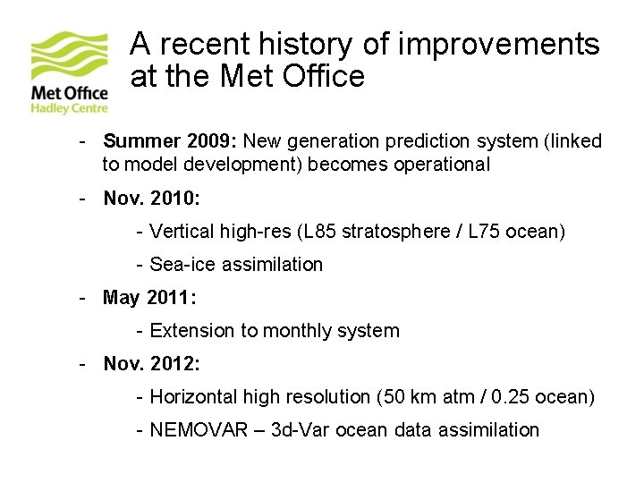
A recent history of improvements at the Met Office - Summer 2009: New generation prediction system (linked to model development) becomes operational - Nov. 2010: - Vertical high-res (L 85 stratosphere / L 75 ocean) - Sea-ice assimilation - May 2011: - Extension to monthly system - Nov. 2012: - Horizontal high resolution (50 km atm / 0. 25 ocean) - NEMOVAR – 3 d-Var ocean data assimilation © Crown copyright Met Office

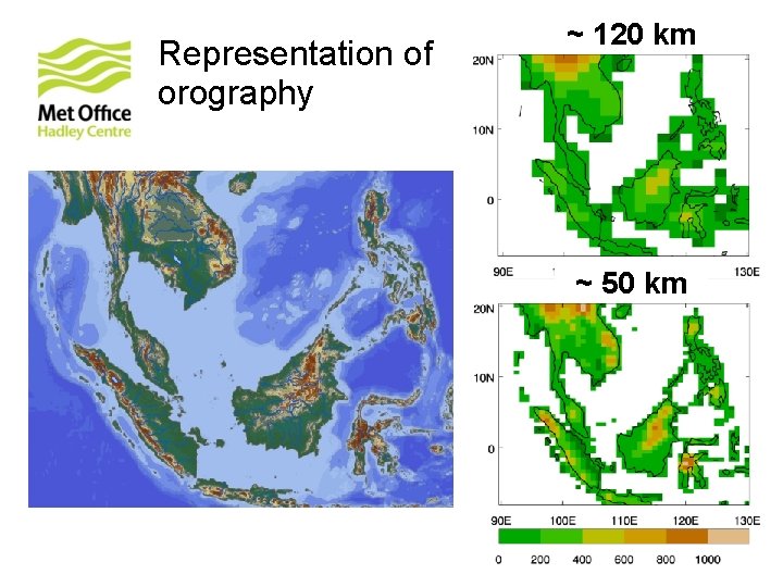
Representation of orography ~ 120 km ~ 50 km © Crown copyright Met Office

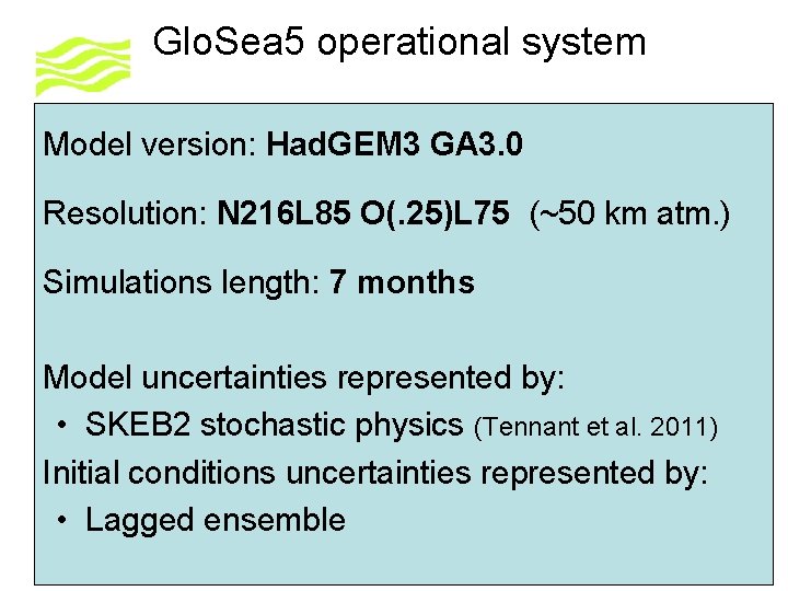
Glo. Sea 5 operational system Model version: Had. GEM 3 GA 3. 0 Resolution: N 216 L 85 O(. 25)L 75 (~50 km atm. ) Simulations length: 7 months Model uncertainties represented by: • SKEB 2 stochastic physics (Tennant et al. 2011) Initial conditions uncertainties represented by: • Lagged ensemble

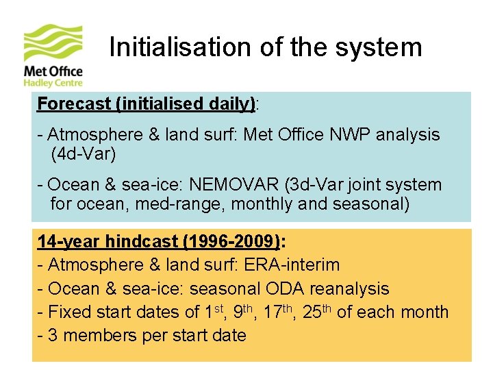
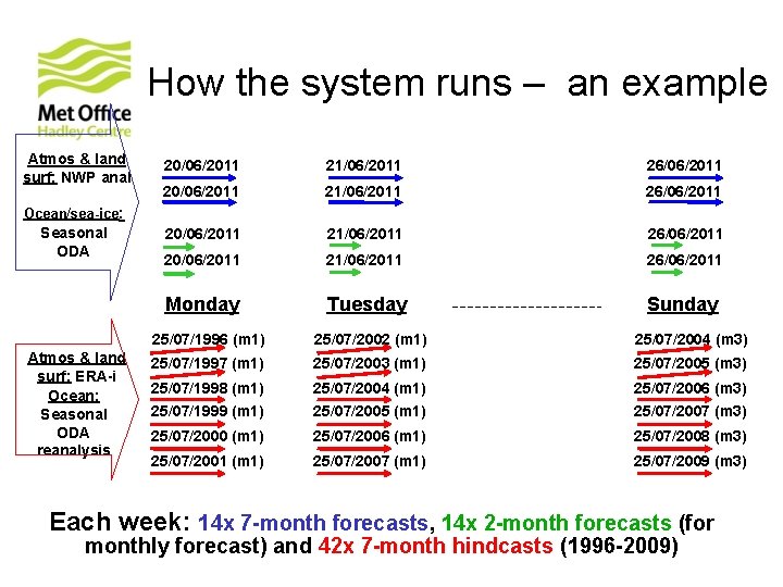
Initialisation of the system Forecast (initialised daily): - Atmosphere & land surf: Met Office NWP analysis (4 d-Var) - Ocean & sea-ice: NEMOVAR (3 d-Var joint system for ocean, med-range, monthly and seasonal) 14 -year hindcast (1996 -2009): - Atmosphere & land surf: ERA-interim - Ocean & sea-ice: seasonal ODA reanalysis - Fixed start dates of 1 st, 9 th, 17 th, 25 th of each month - 3 members per start date © Crown copyright Met Office

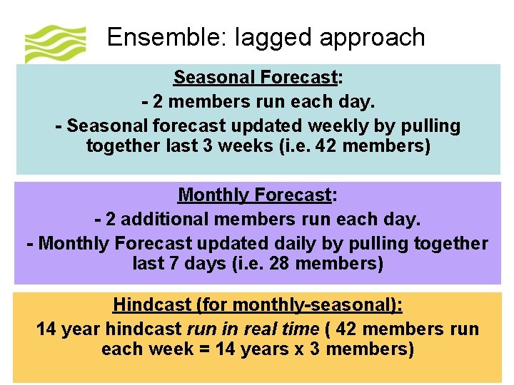
Ensemble: lagged approach Seasonal Forecast: - 2 members run each day. - Seasonal forecast updated weekly by pulling together last 3 weeks (i. e. 42 members) Monthly Forecast: - 2 additional members run each day. - Monthly Forecast updated daily by pulling together last 7 days (i. e. 28 members) Hindcast (for monthly-seasonal): 14 year hindcast run in real time ( 42 members run each week = 14 years x 3 members) © Crown copyright Met Office

How the system runs – an example Atmos & land surf: NWP anal 20/06/2011 21/06/2011 26/06/2011 Monday Tuesday Sunday Ocean/sea-ice: Seasonal ODA Atmos & land surf: ERA-i Ocean: Seasonal ODA reanalysis 25/07/1996 (m 1) 25/07/2002 (m 1) 25/07/2004 (m 3) 25/07/1997 (m 1) 25/07/2003 (m 1) 25/07/2005 (m 3) 25/07/1998 (m 1) 25/07/2004 (m 1) 25/07/2006 (m 3) 25/07/1999 (m 1) 25/07/2005 (m 1) 25/07/2007 (m 3) 25/07/2000 (m 1) 25/07/2006 (m 1) 25/07/2008 (m 3) 25/07/2001 (m 1) 25/07/2007 (m 1) 25/07/2009 (m 3) Each week: 14 x 7 -month forecasts, 14 x 2 -month forecasts (for monthly forecast) and 42 x 7 -month hindcasts (1996 -2009) © Crown copyright Met Office

Outline • configuration of latest operational system • analysis of hindcasts • ENSO • (N)AO • WNPSH • rainfall ‘extremes’ • tropical storms © Crown copyright Met Office

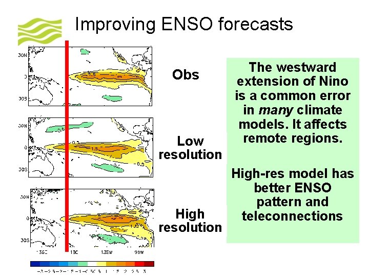
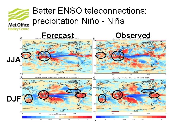
Improving ENSO forecasts Obs Low resolution High resolution © Crown copyright Met Office The westward extension of Nino is a common error in many climate models. It affects remote regions. High-res model has better ENSO pattern and teleconnections

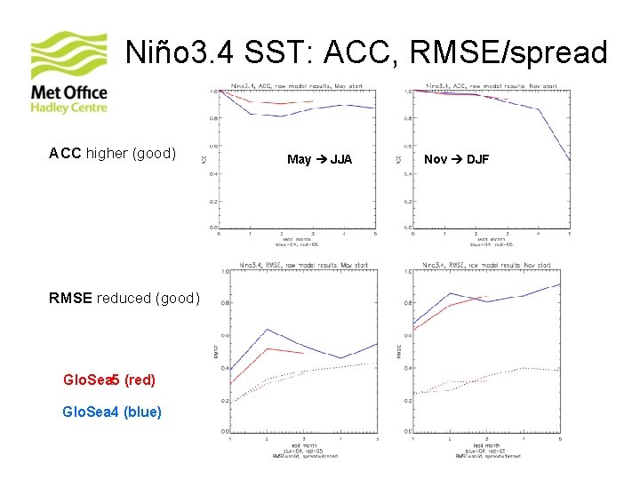
Niño 3. 4 SST: ACC, RMSE/spread ACC higher (good) RMSE reduced (good) Glo. Sea 5 (red) Glo. Sea 4 (blue) © Crown copyright Met Office May JJA Nov DJF

Better ENSO teleconnections: precipitation Niño - Niña Forecast JJA DJF © Crown copyright Met Office Observed

Outline • configuration of latest operational system • analysis of hindcasts • ENSO • (N)AO • WNPSH • rainfall ‘extremes’ • tropical storms © Crown copyright Met Office

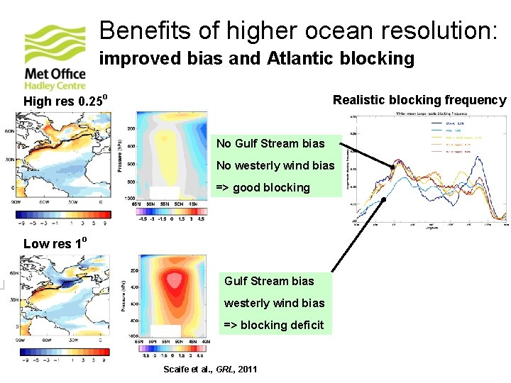
Benefits of higher ocean resolution: improved bias and Atlantic blocking High res 0. 25 o Realistic blocking frequency No Gulf Stream bias No westerly wind bias => good blocking Low res 1 o Gulf Stream bias westerly wind bias => blocking deficit © Crown copyright Met Office Scaife et al. , GRL, 2011

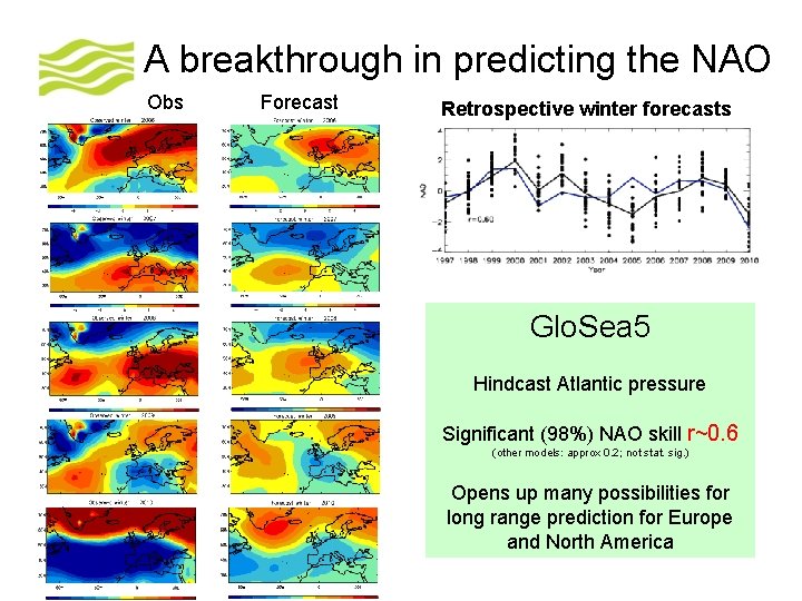
A breakthrough in predicting the NAO Obs Forecast Retrospective winter forecasts Glo. Sea 5 Hindcast Atlantic pressure Significant (98%) NAO skill r~0. 6 (other models: approx 0. 2; not stat. sig. ) Opens up many possibilities for long range prediction for Europe and North America © Crown copyright Met Office

Outline • configuration of latest operational system • analysis of hindcasts • ENSO • (N)AO • WNPSH • rainfall ‘extremes’ • tropical storms © Crown copyright Met Office

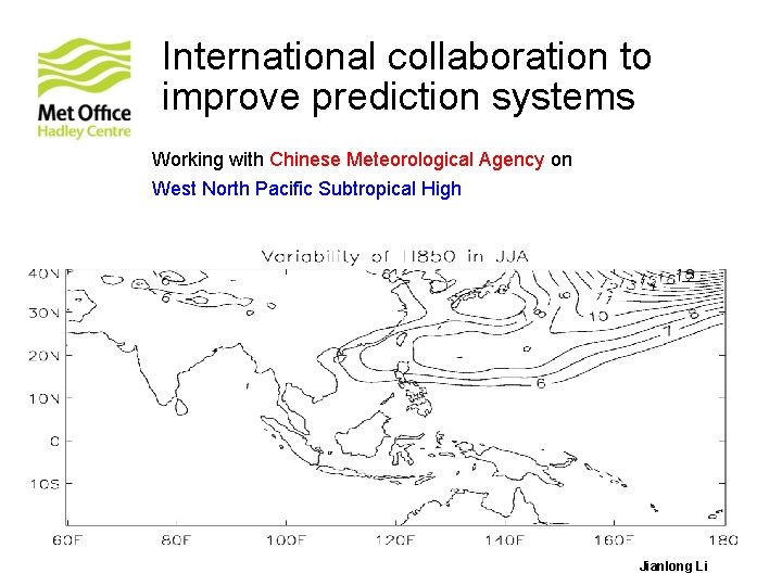
International collaboration to improve prediction systems Working with Chinese Meteorological Agency on West North Pacific Subtropical High © Crown copyright Met Office Jianlong Li

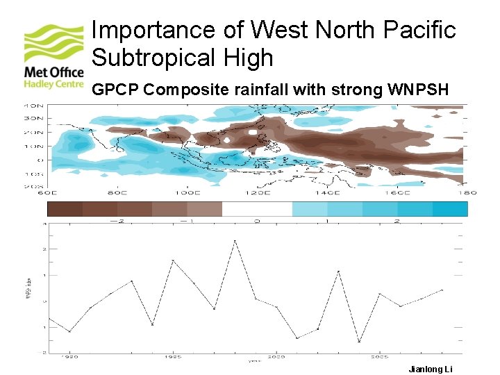
Importance of West North Pacific Subtropical High GPCP Composite rainfall with strong WNPSH © Crown copyright Met Office Jianlong Li

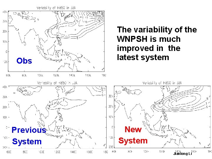
Obs Previous System © Crown copyright Met Office The variability of the WNPSH is much improved in the latest system New System Jianlong Li

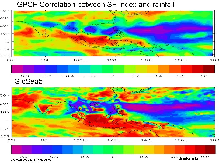
GPCP Correlation between SH index and rainfall Glo. Sea 5 © Crown copyright Met Office Jianlong Li

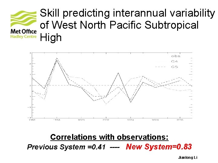
Skill predicting interannual variability of West North Pacific Subtropical High Correlations with observations: Previous System =0. 41 ---- New System=0. 83 © Crown copyright Met Office Jianlong Li

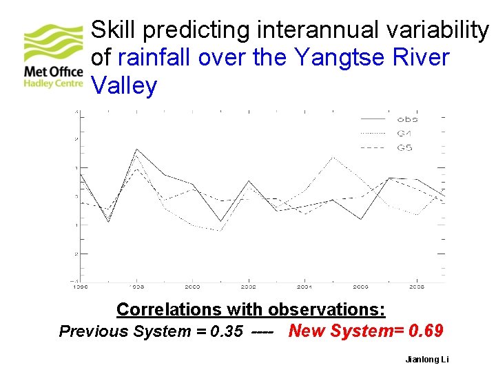
Skill predicting interannual variability of rainfall over the Yangtse River Valley Correlations with observations: Previous System = 0. 35 ---- New System= 0. 69 © Crown copyright Met Office Jianlong Li

Outline • configuration of latest operational system • analysis of hindcasts • ENSO • (N)AO • WNPSH • rainfall ‘extremes’ • tropical storms © Crown copyright Met Office

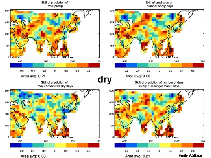
dry © Crown copyright Met Office Emily Wallace

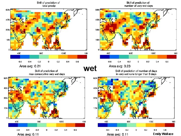
wet © Crown copyright Met Office Emily Wallace

Outline • configuration of latest operational system • analysis of hindcasts • ENSO • (N)AO • WNPSH • rainfall ‘extremes’ • tropical storms © Crown copyright Met Office

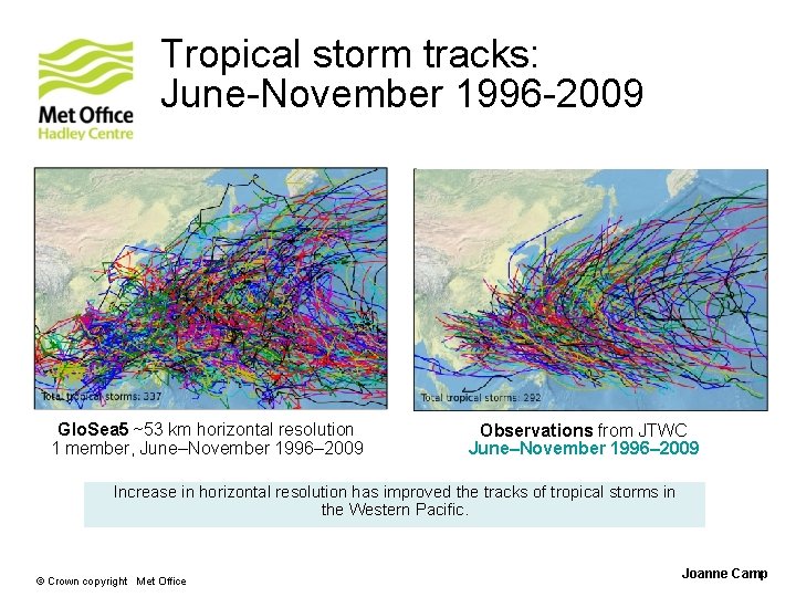
Tropical storm tracks: June-November 1996 -2009 Glo. Sea 5 ~53 km horizontal resolution 1 member, June–November 1996– 2009 Observations from JTWC June–November 1996– 2009 Increase in horizontal resolution has improved the tracks of tropical storms in the Western Pacific. © Crown copyright Met Office Joanne Camp

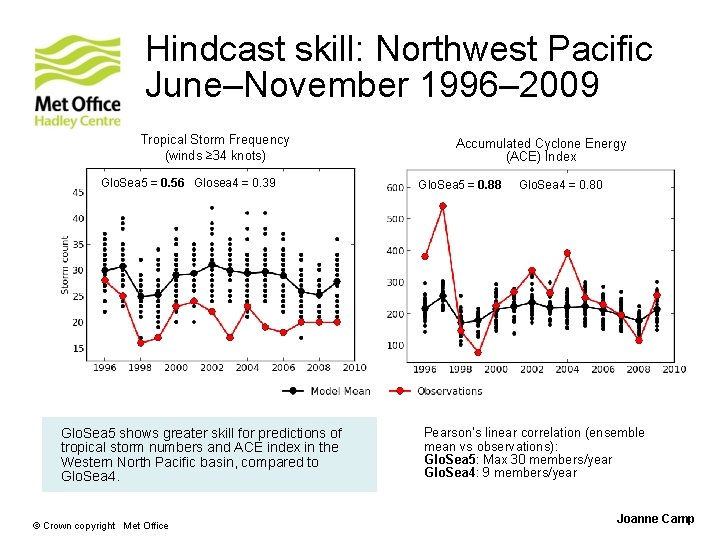
Hindcast skill: Northwest Pacific June–November 1996– 2009 Tropical Storm Frequency (winds ≥ 34 knots) Glo. Sea 5 = 0. 56 Glosea 4 = 0. 39 Glo. Sea 5 shows greater skill for predictions of tropical storm numbers and ACE index in the Western North Pacific basin, compared to Glo. Sea 4. © Crown copyright Met Office Accumulated Cyclone Energy (ACE) Index Glo. Sea 5 = 0. 88 Glo. Sea 4 = 0. 80 Pearson’s linear correlation (ensemble mean vs observations): Glo. Sea 5: Max 30 members/year Glo. Sea 4: 9 members/year Joanne Camp

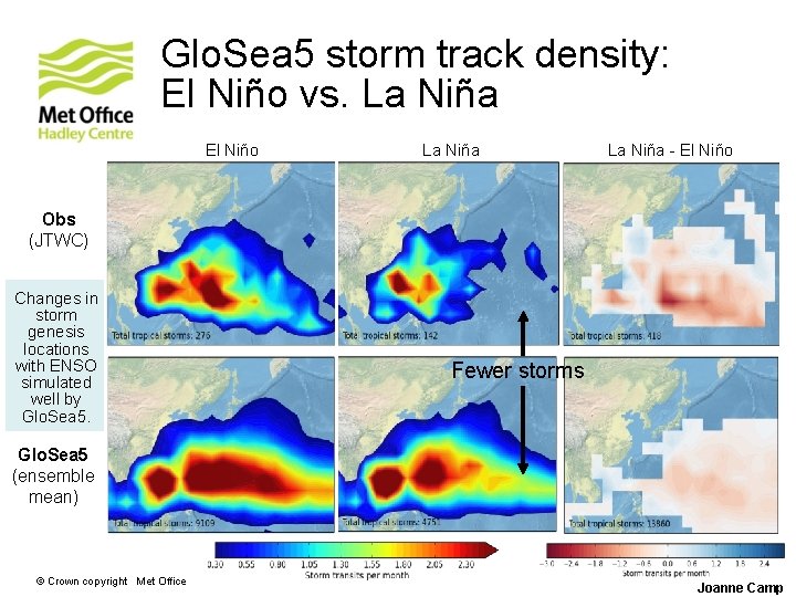
Glo. Sea 5 storm track density: El Niño vs. La Niña El Niño La Niña - El Niño Obs (JTWC) Changes in storm genesis locations with ENSO simulated well by Glo. Sea 5. Fewer storms Glo. Sea 5 (ensemble mean) © Crown copyright Met Office Joanne Camp

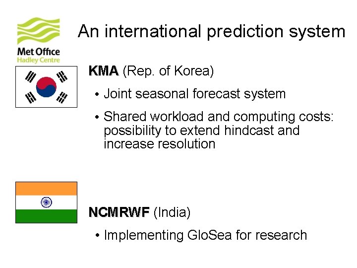
An international prediction system KMA (Rep. of Korea) • Joint seasonal forecast system • Shared workload and computing costs: possibility to extend hindcast and increase resolution NCMRWF (India) • Implementing Glo. Sea for research © Crown copyright Met Office

Seamless system across timescales Glo. Sea 5 med-range (2013) • Project to merge with med-range in 2013 • Aim is to have a single operational system (using coupled model at the highest possible resolution) for short-range ocean, med-range, monthly and seasonal – at the end of 2013 Glo. Sea 5 decadal (2014) • System to be extended – in research mode - to decadal timescales in 2013 • Seamless system med-range to decadal from 2014 © Crown copyright Met Office

Thank you. © Crown copyright Met Office