High resolution model developments at the Met Office

- Slides: 72

High resolution model developments at the Met Office Mike Bush Thanks to Jorge Bornemann, Peter Lean, Alison Eadie, Pete Francis, Martin Young and many others for 31 st EWGLAM and 16 th SRNWP Annual Meeting 2009 28 th September – 1 st October 2009 Athens, Greece © Crown copyright Met Office

Talk Outline • What is the UKV convective scale model good at ? and what is it not good at ? • L 70 NAE - better cloud and inversions thanks to improved vertical resolution © Crown copyright Met Office

Talk Outline • What is the UKV convective scale model good at ? and what is it not good at ? • L 70 NAE - better cloud and inversions thanks to improved vertical resolution © Crown copyright Met Office

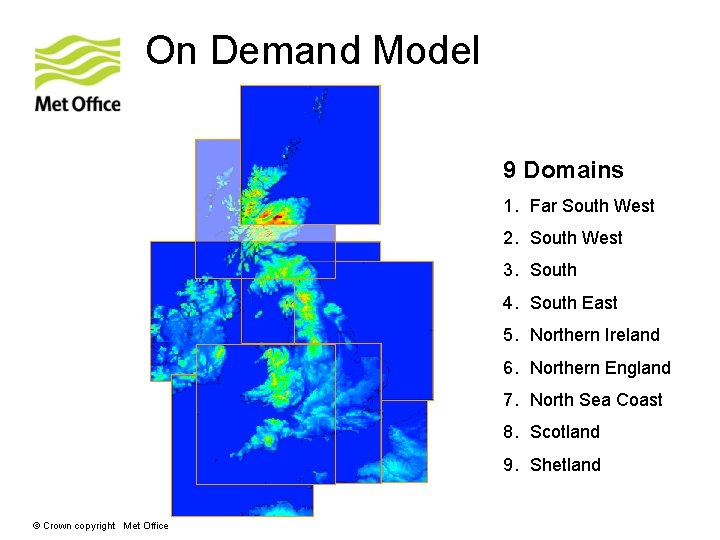
On Demand Model 9 Domains 1. Far South West 2. South West 3. South 4. South East 5. Northern Ireland 6. Northern England 7. North Sea Coast 8. Scotland 9. Shetland © Crown copyright Met Office

On Demand Model • Nested in UK 4. • 300 x 300 gridboxes, approximately 450 km x 450 km. • 1. 5 Km gridbox length. • 70 levels. • Spin-up from UK 4 T+1. Forecast length 18 hours. • LBC update frequency: 30 min. • Available after any main UK 4 forecast. • Discontinued 1 st August 2009 © Crown copyright Met Office

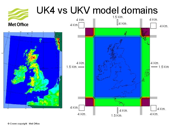
UK 4 vs UKV model domains 4 Km. 1. 5 Km. 4 Km. © Crown copyright Met Office 4 Km. 1. 5 Km. 4 Km.

UKV Model • Nested in NAE (12 Km gridlength) • Variable Resolution. Outer rim 4 Km gridlength • Inner area 1. 5 Km gridlength • Inner area size: • 622 gridboxes E-W • 810 gridboxes. N-S • Full area size: • 744 gridboxes E-W • 928 N-W • LBC update frequency: 30 min. • 70 vertical levels. Model top: 40000 m. • Timestep: 50 sec. • Forecast length: 24 hours © Crown copyright Met Office

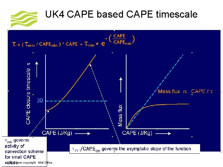
UKV vs UK 4 science differences • Convection scheme turned off in UKV model • CAPE based CAPE timescale in UK 4 model - shallow convection is still parametrized • Shallow convection partly resolved by UKV dynamics • Boundary layer scheme allowed to work the full depth of the model to mitigate instabilities (see poster) • 2 D Smagorinsky- Lilley turbulence scheme replaces horizontal diffusion • Orographic drag off in UKV model © Crown copyright Met Office

UK 4 CAPE based CAPE timescale © Crown copyright Met Office

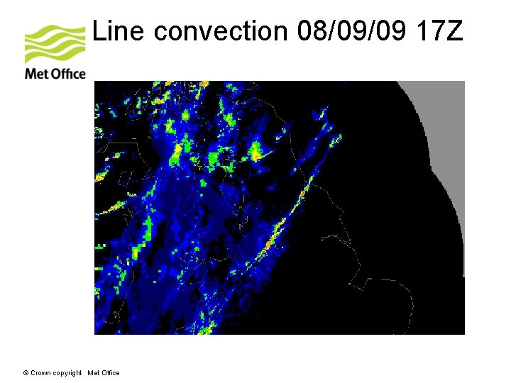
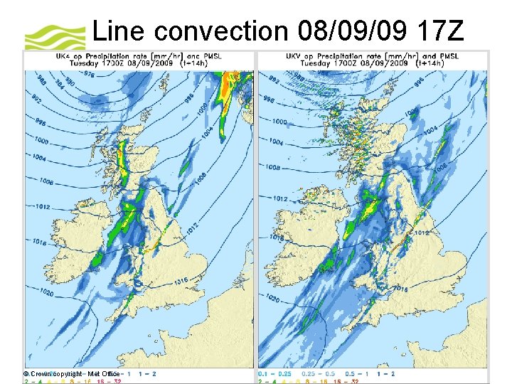
UKV does well at… • Spin up from boundaries • Orographically forced cloud/precip • Inland penetration of marine showers/clouds • Precipitation structure within fronts/line convection • Convergence lines from peninsulas • Sea breezes © Crown copyright Met Office

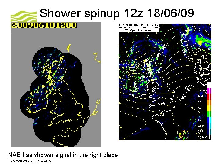
Shower spinup 12 z 18/06/09 NAE has shower signal in the right place. © Crown copyright Met Office

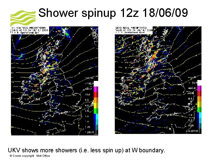
Shower spinup 12 z 18/06/09 UKV shows more showers (i. e. less spin up) at W boundary. © Crown copyright Met Office

UKV does well at… • Spin up from boundaries • Orographically forced cloud/precip • Inland penetration of marine showers/clouds • Precipitation structure within fronts/line convection • Convergence lines from peninsulas • Sea breezes © Crown copyright Met Office

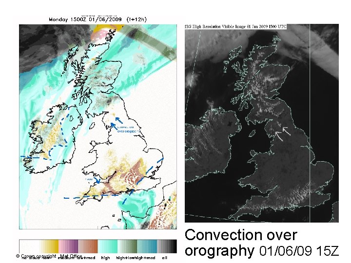
© Crown copyright Met Office Convection over orography 01/06/09 15 Z

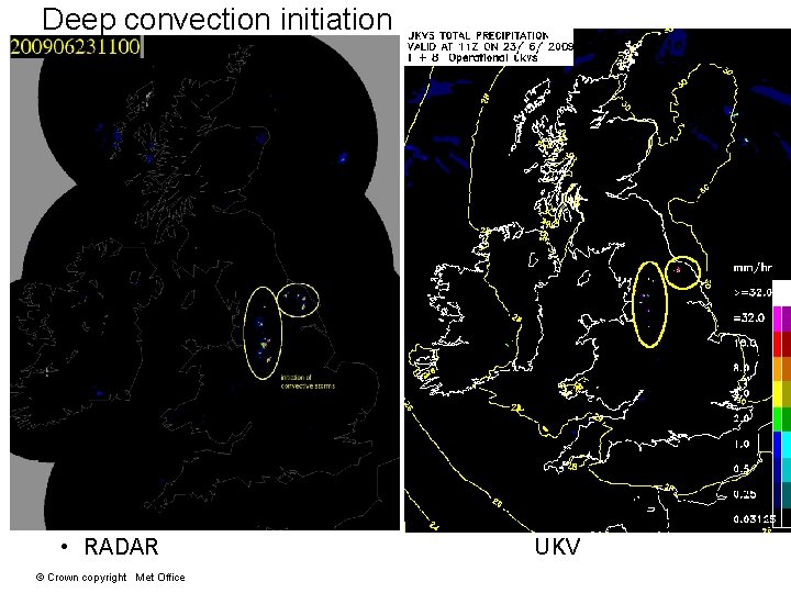
Deep convection initiation • RADAR © Crown copyright Met Office UKV

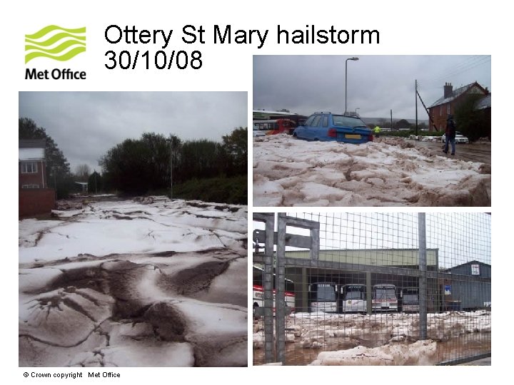
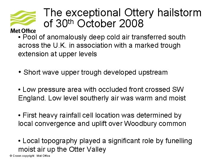
Ottery St Mary hailstorm 30/10/08 © Crown copyright Met Office

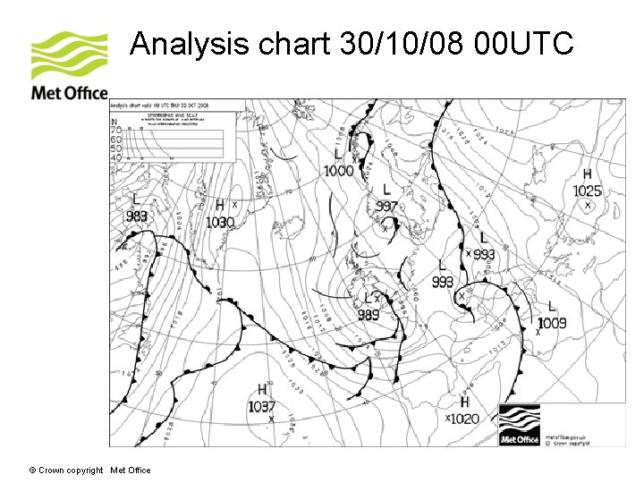
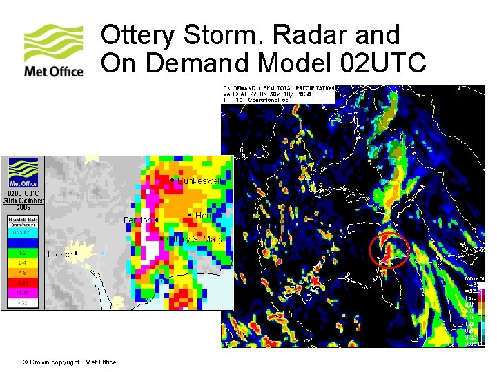
The exceptional Ottery hailstorm of 30 th October 2008 • Pool of anomalously deep cold air transferred south across the U. K. in association with a marked trough extension at upper levels • Short wave upper trough developed upstream • Low pressure area with occluded front crossed SW England. Low level southerly air was warm and moist • First heavy rainfall cell location was determined by local convergence and uplift over Woodbury common • Local topography played a significant role by funelling moist air up the Otter Valley © Crown copyright Met Office

Analysis chart 30/10/08 00 UTC © Crown copyright Met Office

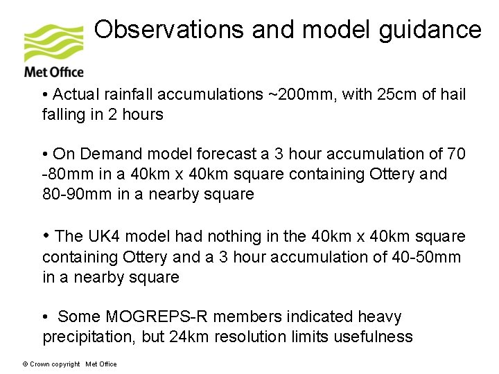
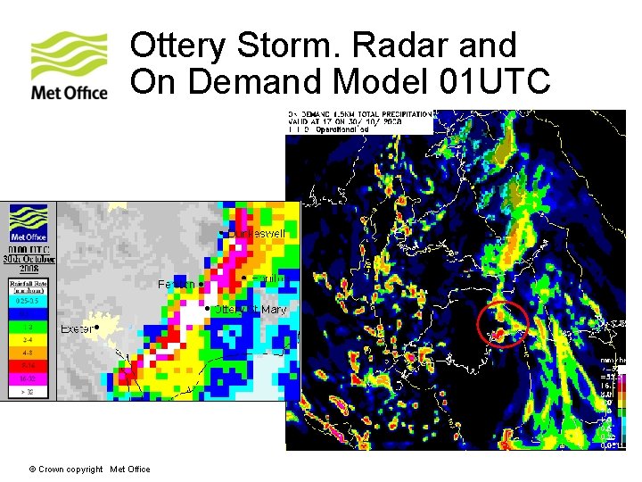
Observations and model guidance • Actual rainfall accumulations ~200 mm, with 25 cm of hail falling in 2 hours • On Demand model forecast a 3 hour accumulation of 70 -80 mm in a 40 km x 40 km square containing Ottery and 80 -90 mm in a nearby square • The UK 4 model had nothing in the 40 km x 40 km square containing Ottery and a 3 hour accumulation of 40 -50 mm in a nearby square • Some MOGREPS-R members indicated heavy precipitation, but 24 km resolution limits usefulness © Crown copyright Met Office

Ottery Storm. Radar and On Demand Model 01 UTC © Crown copyright Met Office

Ottery Storm. Radar and On Demand Model 02 UTC © Crown copyright Met Office

UKV does well at… • Spin up from boundaries • Orographically forced cloud/precip • Inland penetration of marine showers/clouds • Precipitation structure within fronts/line convection • Convergence lines from peninsulas • Sea breezes © Crown copyright Met Office

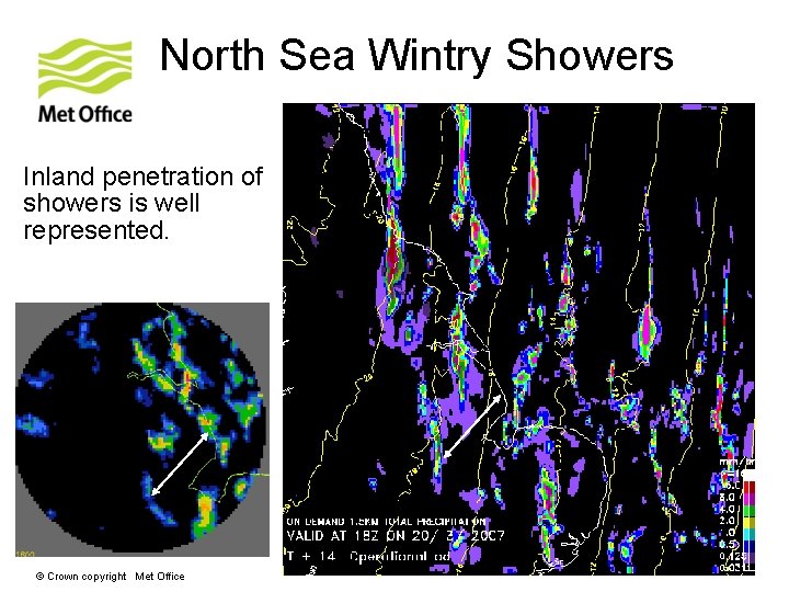
North Sea Wintry Showers Inland penetration of showers is well represented. © Crown copyright Met Office

UKV does well at… • Spin up from boundaries • Orographically forced precip/cloud • Inland penetration of marine showers/clouds • Precipitation structure within fronts/line convection • Convergence lines from peninsulas • Sea breezes © Crown copyright Met Office

Line convection 08/09/09 17 Z © Crown copyright Met Office

Line convection 08/09/09 17 Z © Crown copyright Met Office

UKV does well at… • Spin up from boundaries • Orographically forced precip/cloud • Inland penetration of marine showers/clouds • Precipitation structure within fronts/line convection • Convergence lines from peninsulas • Sea breezes © Crown copyright Met Office

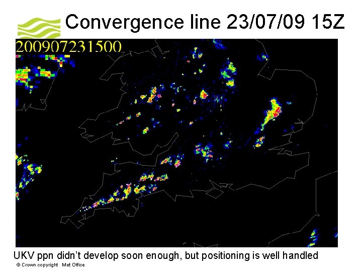
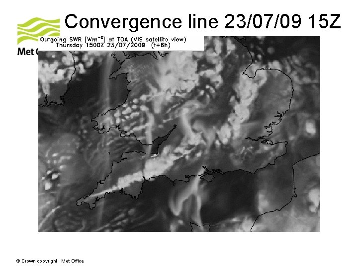
Convergence line 23/07/09 15 Z UKV ppn didn’t develop soon enough, but positioning is well handled © Crown copyright Met Office

Convergence line 23/07/09 15 Z © Crown copyright Met Office

UKV does well at… • Spin up from boundaries • Orographically forced precip/cloud • Inland penetration of marine showers/clouds • Precipitation structure within fronts/line convection • Convergence lines from peninsulas • Sea breezes © Crown copyright Met Office

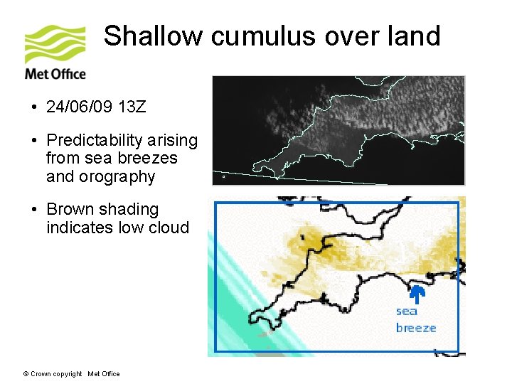
Shallow cumulus over land • 24/06/09 13 Z • Predictability arising from sea breezes and orography • Brown shading indicates low cloud © Crown copyright Met Office

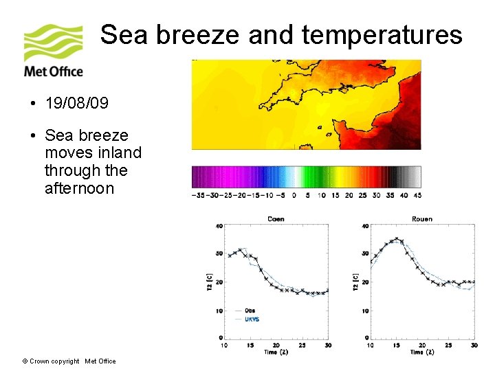
Sea breeze and temperatures • 19/08/09 • Sea breeze moves inland through the afternoon © Crown copyright Met Office

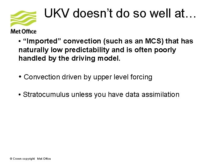
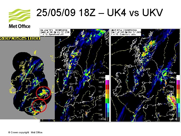
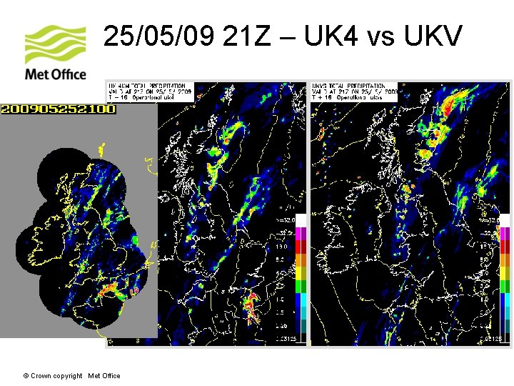
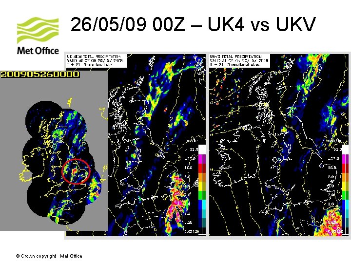
UKV doesn’t do so well at… • “Imported” convection (such as an MCS) that has naturally low predictability and is often poorly handled by the driving model. • Convection driven by upper level forcing • Stratocumulus unless you have data assimilation © Crown copyright Met Office

25/05/09 18 Z – UK 4 vs UKV © Crown copyright Met Office

25/05/09 21 Z – UK 4 vs UKV © Crown copyright Met Office

26/05/09 00 Z – UK 4 vs UKV © Crown copyright Met Office

UKV doesn’t do so well at… • “Imported” convection (such as an MCS) that has naturally low predictability and is often poorly handled by the driving model. • Convection driven by upper level forcing • Stratocumulus unless you have data assimilation © Crown copyright Met Office

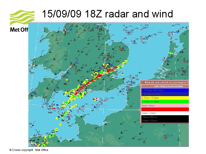
15/09/09 18 Z radar and wind © Crown copyright Met Office

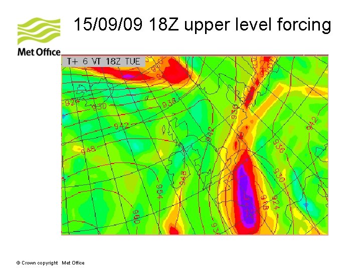
15/09/09 18 Z upper level forcing © Crown copyright Met Office

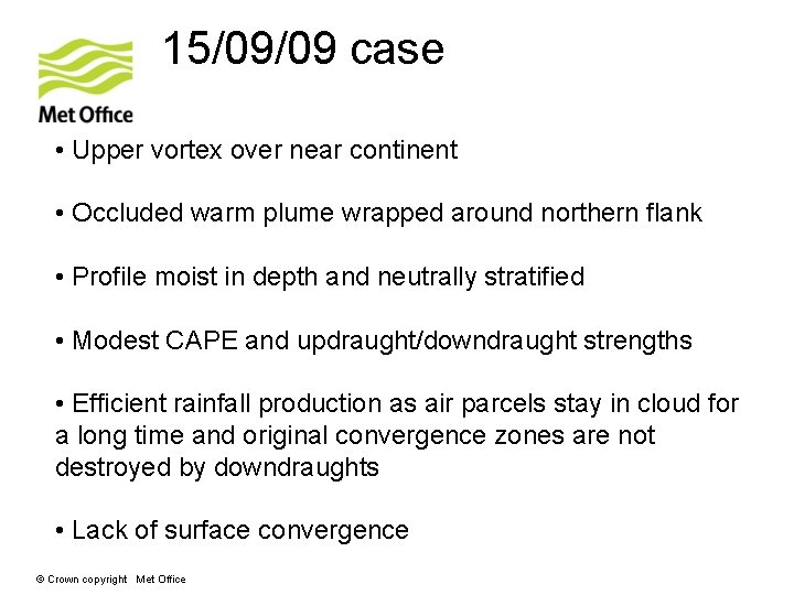
15/09/09 case • Upper vortex over near continent • Occluded warm plume wrapped around northern flank • Profile moist in depth and neutrally stratified • Modest CAPE and updraught/downdraught strengths • Efficient rainfall production as air parcels stay in cloud for a long time and original convergence zones are not destroyed by downdraughts • Lack of surface convergence © Crown copyright Met Office

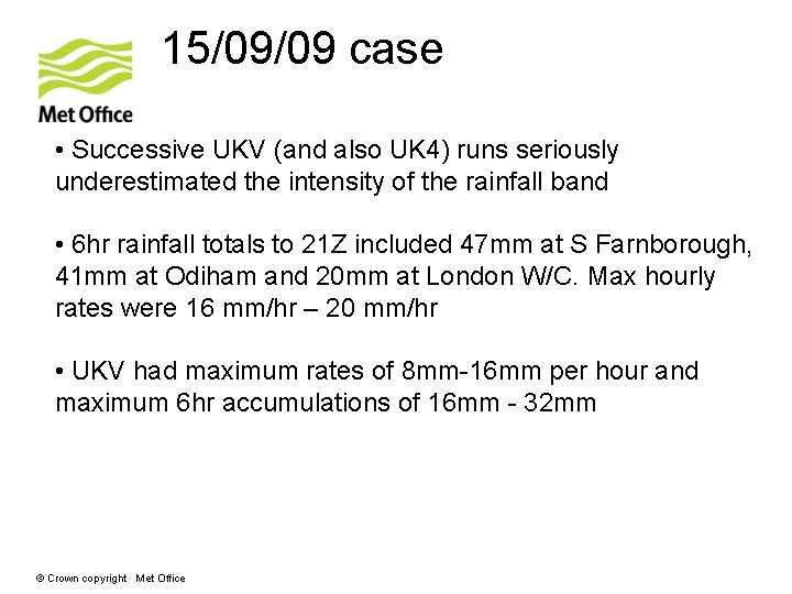
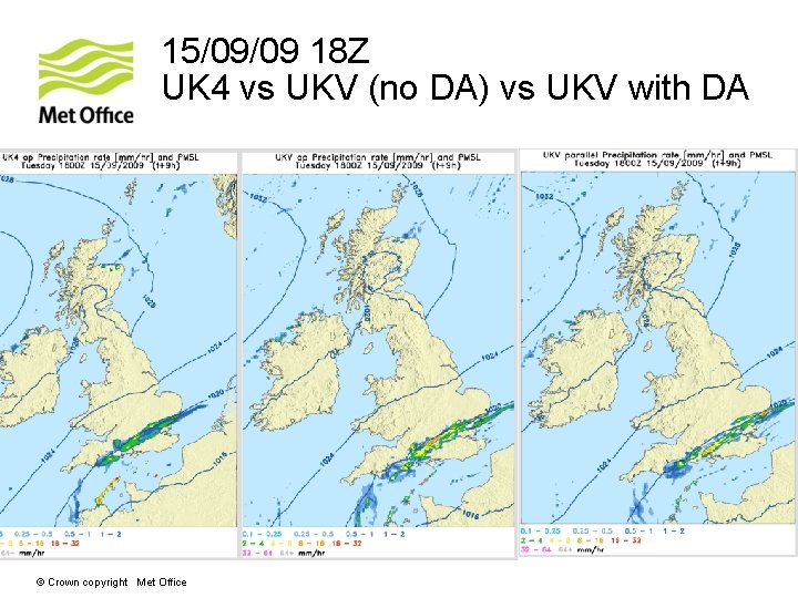
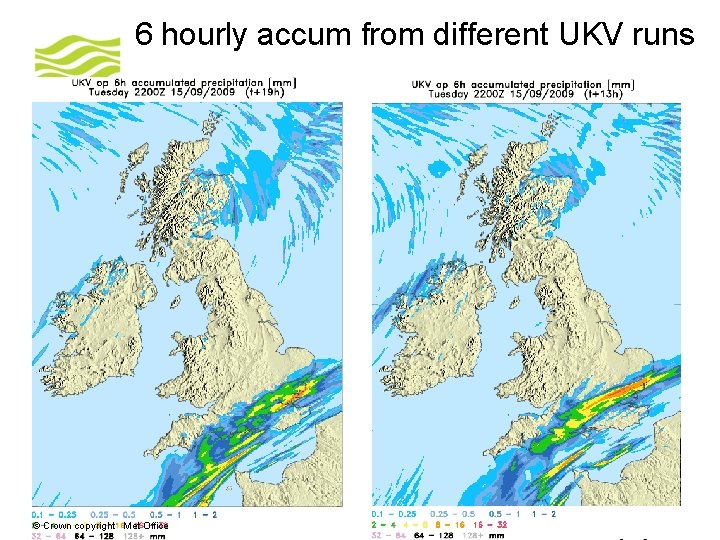
15/09/09 case • Successive UKV (and also UK 4) runs seriously underestimated the intensity of the rainfall band • 6 hr rainfall totals to 21 Z included 47 mm at S Farnborough, 41 mm at Odiham and 20 mm at London W/C. Max hourly rates were 16 mm/hr – 20 mm/hr • UKV had maximum rates of 8 mm-16 mm per hour and maximum 6 hr accumulations of 16 mm - 32 mm © Crown copyright Met Office

15/09/09 18 Z UK 4 vs UKV (no DA) vs UKV with DA © Crown copyright Met Office

6 hourly accum from different UKV runs © Crown copyright Met Office

UKV doesn’t do so well at… • “Imported” convection (such as an MCS) that has naturally low predictability and is often poorly handled by the driving model. • Convection driven by upper level forcing • Stratocumulus unless you have data assimilation © Crown copyright Met Office

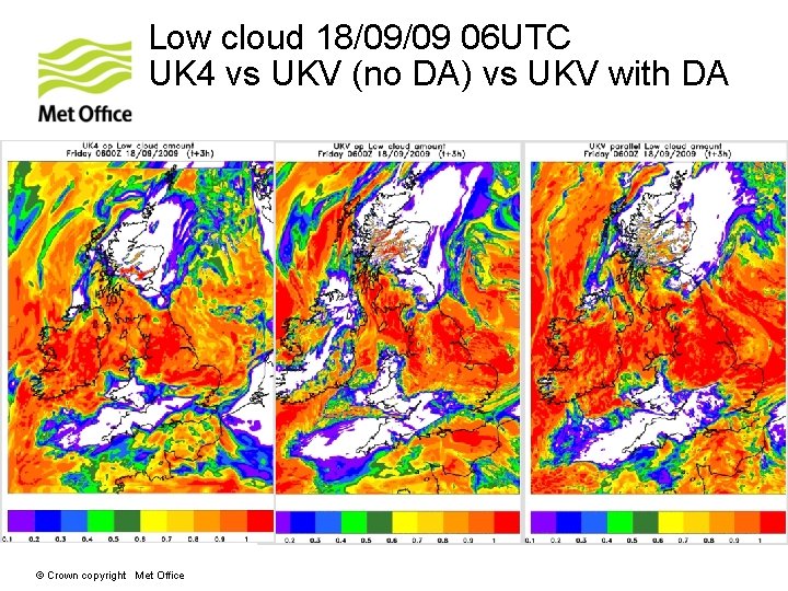
Low cloud 18/09/09 06 UTC UK 4 vs UKV (no DA) vs UKV with DA © Crown copyright Met Office

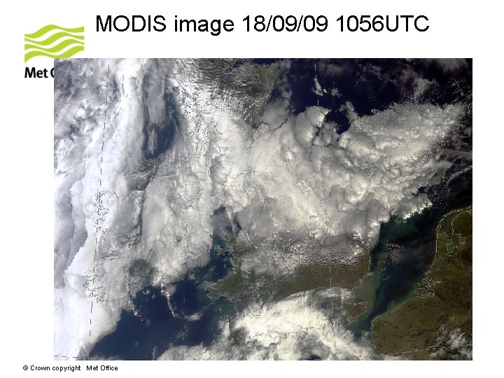
MODIS image 18/09/09 1056 UTC © Crown copyright Met Office

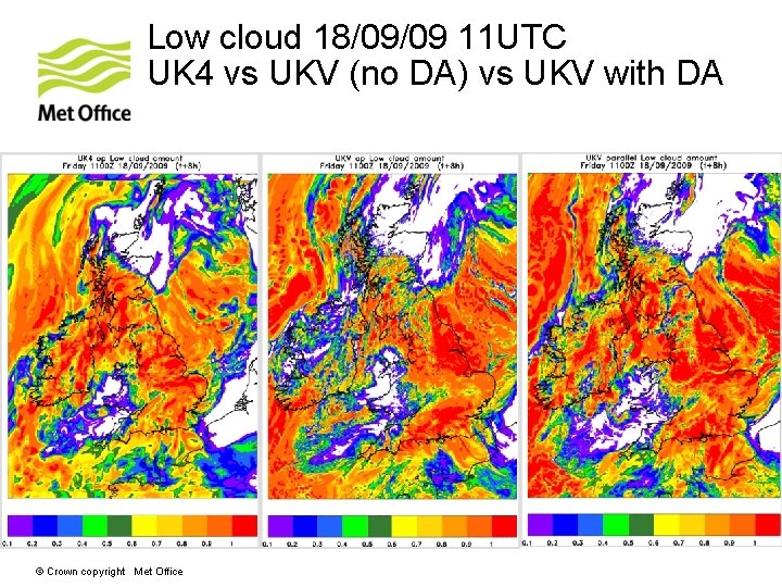
Low cloud 18/09/09 11 UTC UK 4 vs UKV (no DA) vs UKV with DA © Crown copyright Met Office

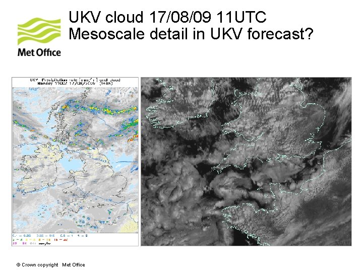
UKV cloud 17/08/09 11 UTC Mesoscale detail in UKV forecast? © Crown copyright Met Office

Talk Outline • What is the UKV convective scale model good at ? and what is it not good at ? • L 70 NAE - better cloud and inversions thanks to improved vertical resolution © Crown copyright Met Office

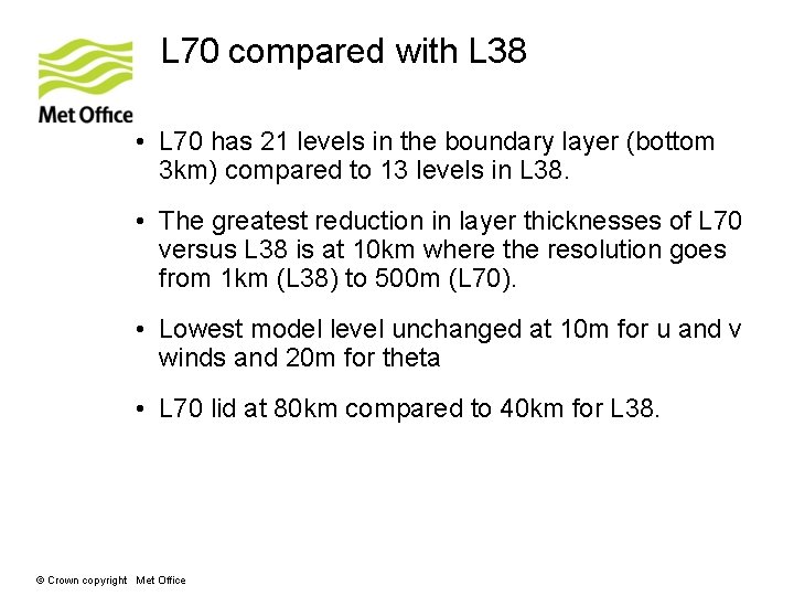
L 70 compared with L 38 • L 70 has 21 levels in the boundary layer (bottom 3 km) compared to 13 levels in L 38. • The greatest reduction in layer thicknesses of L 70 versus L 38 is at 10 km where the resolution goes from 1 km (L 38) to 500 m (L 70). • Lowest model level unchanged at 10 m for u and v winds and 20 m for theta • L 70 lid at 80 km compared to 40 km for L 38. © Crown copyright Met Office

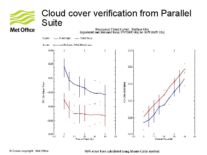
Cloud cover verification from Parallel Suite © Crown copyright Met Office

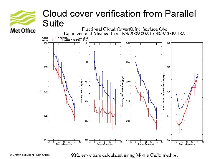
Cloud cover verification from Parallel Suite © Crown copyright Met Office

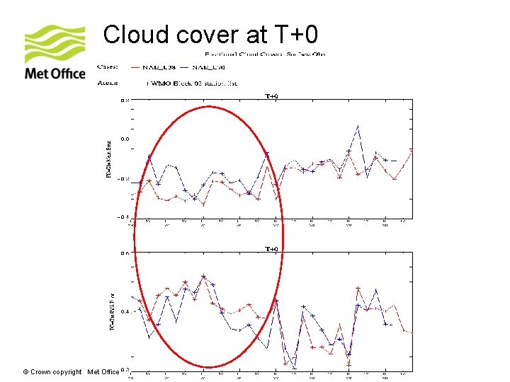
Cloud cover at T+0 © Crown copyright Met Office

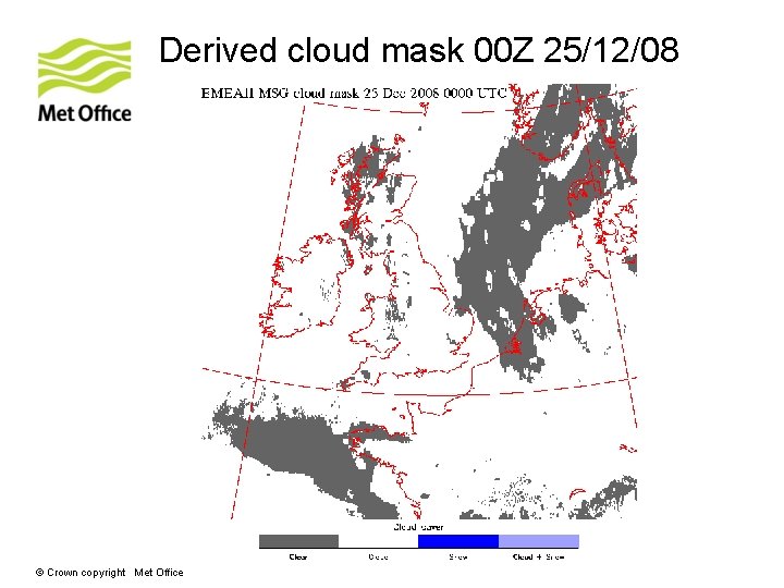
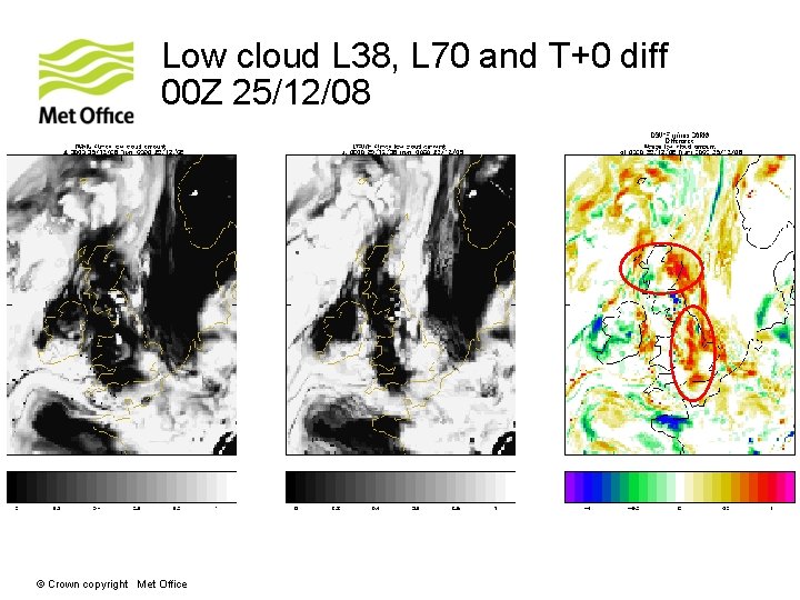
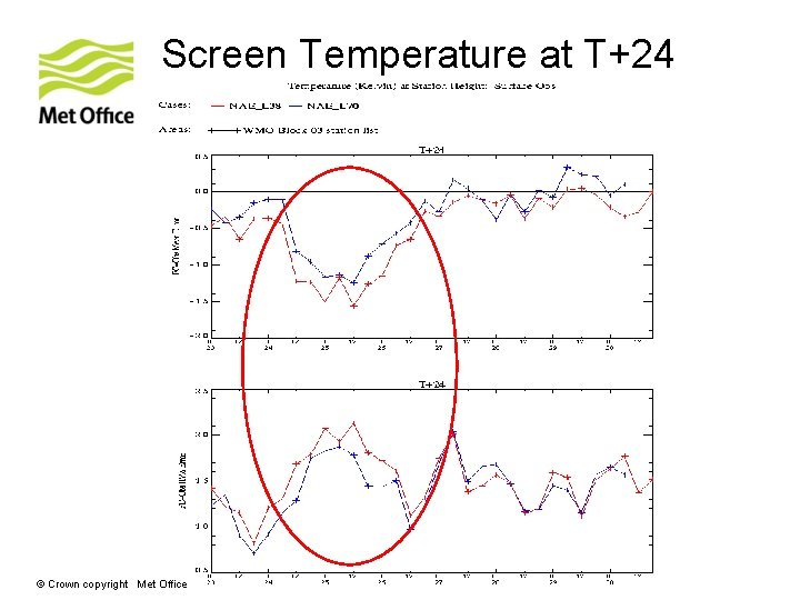
Model Assessment and emphasis • NAE low cloud in initial conditions is even worse than background, with most of the British Isles cloud free (Eddy Carroll, 24/12/08). • Fields modified again to increase cloud cover in a major way (Eddy Carroll, 25/12/08). • 06 Z NAE continues to struggle with low cloud assimilation across parts of the UK (Andy Page, 26/12/08). © Crown copyright Met Office

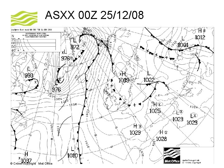
ASXX 00 Z 25/12/08 © Crown copyright Met Office

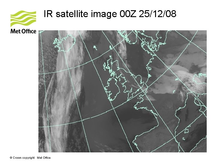
IR satellite image 00 Z 25/12/08 © Crown copyright Met Office

Derived cloud mask 00 Z 25/12/08 © Crown copyright Met Office

Low cloud L 38, L 70 and T+0 diff 00 Z 25/12/08 © Crown copyright Met Office

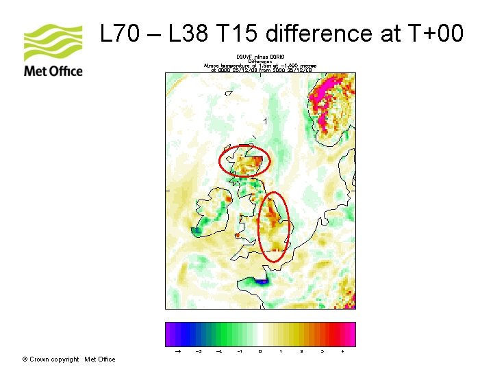
L 70 – L 38 T 15 difference at T+00 © Crown copyright Met Office

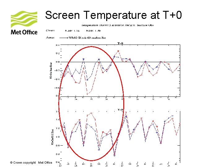
Screen Temperature at T+0 © Crown copyright Met Office

Screen Temperature at T+24 © Crown copyright Met Office

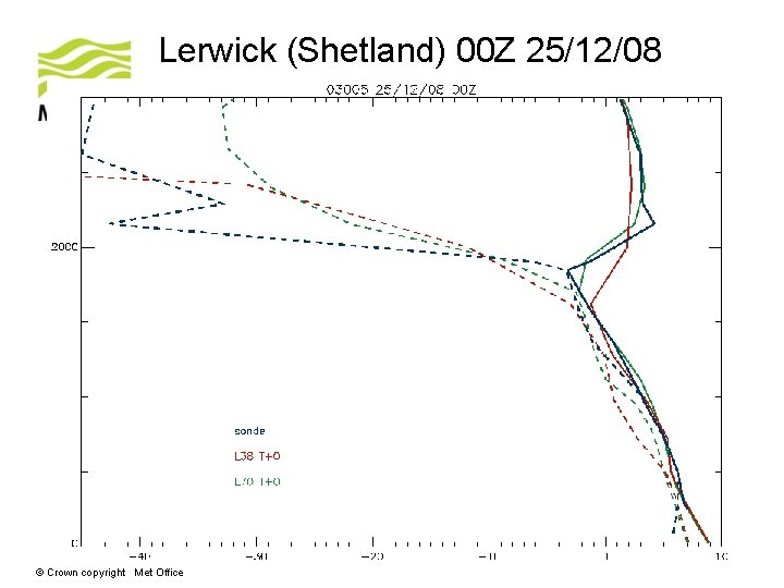
Lerwick (Shetland) 00 Z 25/12/08 © Crown copyright Met Office

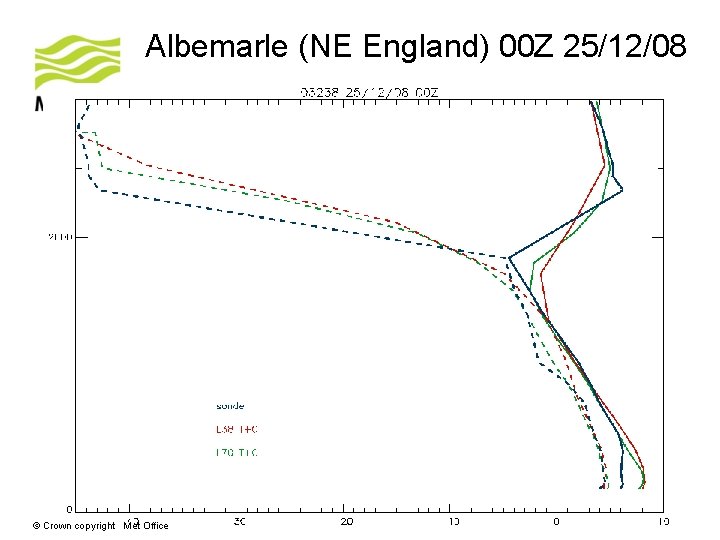
Albemarle (NE England) 00 Z 25/12/08 © Crown copyright Met Office

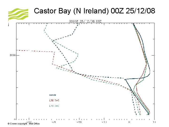
Castor Bay (N Ireland) 00 Z 25/12/08 © Crown copyright Met Office

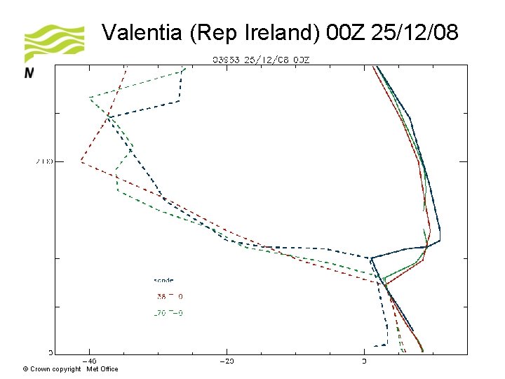
Valentia (Rep Ireland) 00 Z 25/12/08 © Crown copyright Met Office

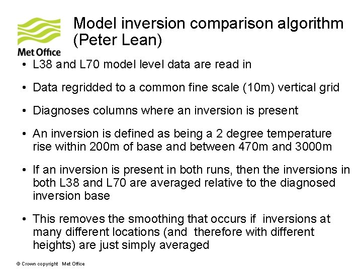
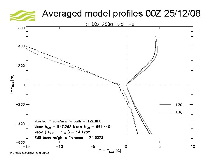
Model inversion comparison algorithm (Peter Lean) • L 38 and L 70 model level data are read in • Data regridded to a common fine scale (10 m) vertical grid • Diagnoses columns where an inversion is present • An inversion is defined as being a 2 degree temperature rise within 200 m of base and between 470 m and 3000 m • If an inversion is present in both runs, then the inversions in both L 38 and L 70 are averaged relative to the diagnosed inversion base • This removes the smoothing that occurs if inversions at many different locations (and therefore with different heights) are just simply averaged © Crown copyright Met Office

Averaged model profiles 00 Z 25/12/08 © Crown copyright Met Office

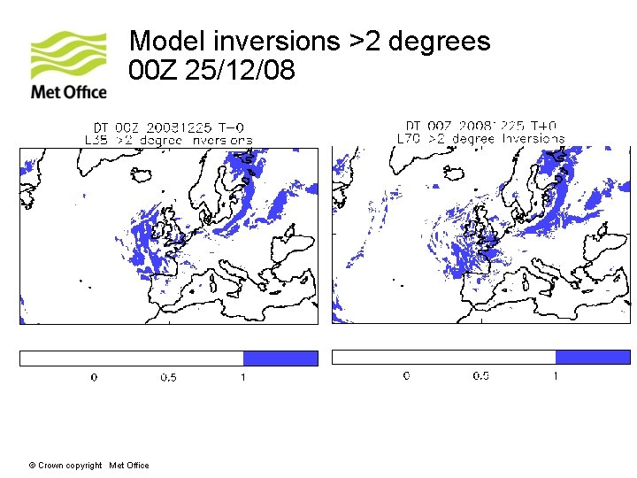
Model inversions >2 degrees 00 Z 25/12/08 © Crown copyright Met Office

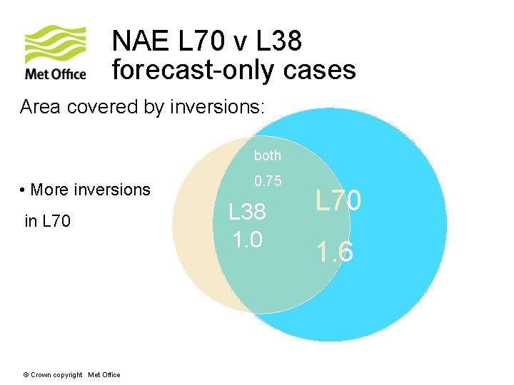
NAE L 70 v L 38 forecast-only cases Area covered by inversions: both • More inversions in L 70 © Crown copyright Met Office 0. 75 L 38 1. 0 L 70 1. 6

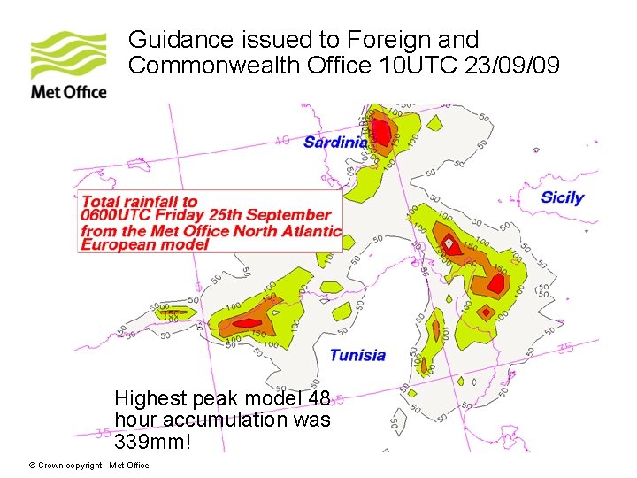
Guidance issued to Foreign and Commonwealth Office 10 UTC 23/09/09 Highest peak model 48 hour accumulation was 339 mm! © Crown copyright Met Office

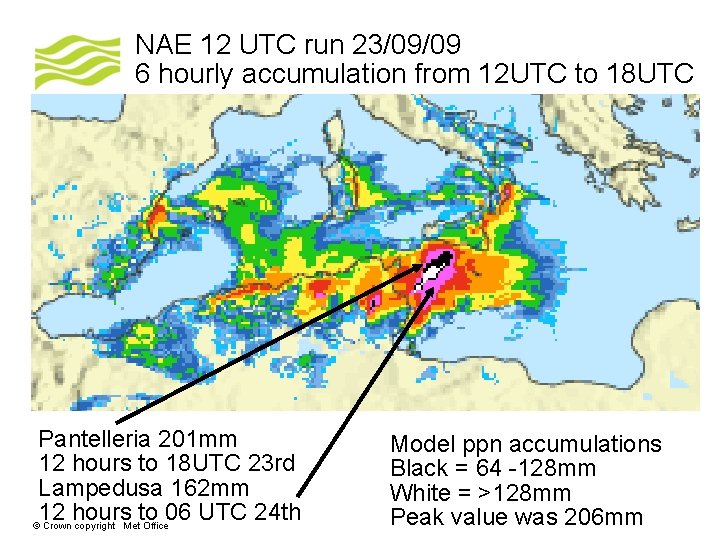
NAE 12 UTC run 23/09/09 6 hourly accumulation from 12 UTC to 18 UTC Pantelleria 201 mm 12 hours to 18 UTC 23 rd Lampedusa 162 mm 12 hours to 06 UTC 24 th © Crown copyright Met Office Model ppn accumulations Black = 64 -128 mm White = >128 mm Peak value was 206 mm

Questions and answers © Crown copyright Met Office