The HWRF No Vortex Initialization HNVI realtime experiment
- Slides: 21

The HWRF No Vortex Initialization (HNVI) realtime experiment Evan Kalina Collaborators: Henry Winterbottom, James Frimel, Jason Sippel, Kathryn Newman, Gus Alaka, Bin Liu, Zhang, Avichal Mehra HWRF Weekly Telecon, 3 October 2019 1

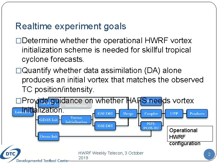
Realtime experiment goals �Determine whether the operational HWRF vortex initialization scheme is needed for skillful tropical cyclone forecasts. �Quantify whether data assimilation (DA) alone produces an initial vortex that matches the observed TC position/intensity. �Provide guidance on whether HAFS needs vortex initialization. Operational HWRF configuration HWRF Weekly Telecon, 3 October 2019 2

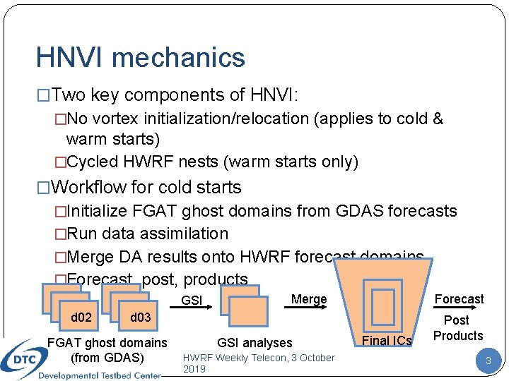
HNVI mechanics �Two key components of HNVI: �No vortex initialization/relocation (applies to cold & warm starts) �Cycled HWRF nests (warm starts only) �Workflow for cold starts �Initialize FGAT ghost domains from GDAS forecasts �Run data assimilation �Merge DA results onto HWRF forecast domains �Forecast, post, products GSI d 02 Merge Forecast d 03 FGAT ghost domains (from GDAS) GSI analyses HWRF Weekly Telecon, 3 October 2019 Final ICs Post Products 3

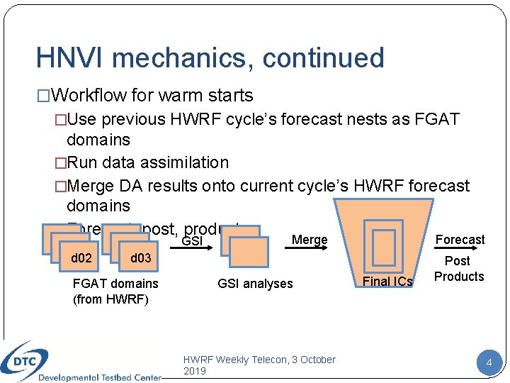
HNVI mechanics, continued �Workflow for warm starts �Use previous HWRF cycle’s forecast nests as FGAT domains �Run data assimilation �Merge DA results onto current cycle’s HWRF forecast domains �Forecast, post, products GSI d 02 Merge Forecast d 03 FGAT domains (from HWRF) GSI analyses HWRF Weekly Telecon, 3 October 2019 Final ICs Post Products 4

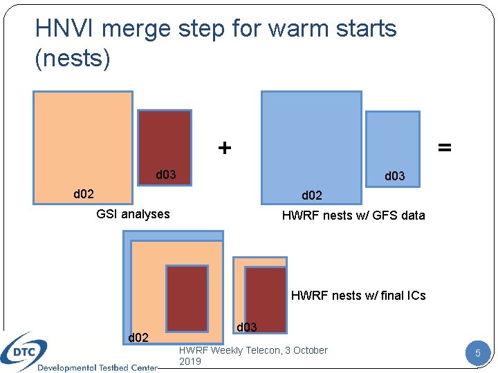
HNVI merge step for warm starts (nests) + = d 03 d 02 GSI analyses HWRF nests w/ GFS data HWRF nests w/ final ICs d 02 d 03 HWRF Weekly Telecon, 3 October 2019 5

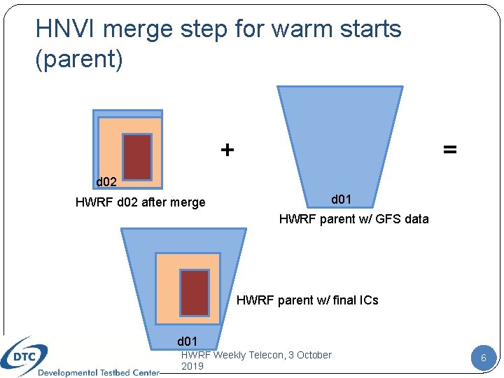
HNVI merge step for warm starts (parent) + = d 02 HWRF d 02 after merge d 01 HWRF parent w/ GFS data HWRF parent w/ final ICs d 01 HWRF Weekly Telecon, 3 October 2019 6

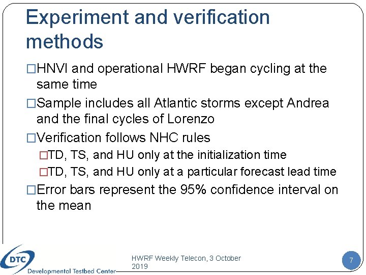
Experiment and verification methods �HNVI and operational HWRF began cycling at the same time �Sample includes all Atlantic storms except Andrea and the final cycles of Lorenzo �Verification follows NHC rules �TD, TS, and HU only at the initialization time �TD, TS, and HU only at a particular forecast lead time �Error bars represent the 95% confidence interval on the mean HWRF Weekly Telecon, 3 October 2019 7

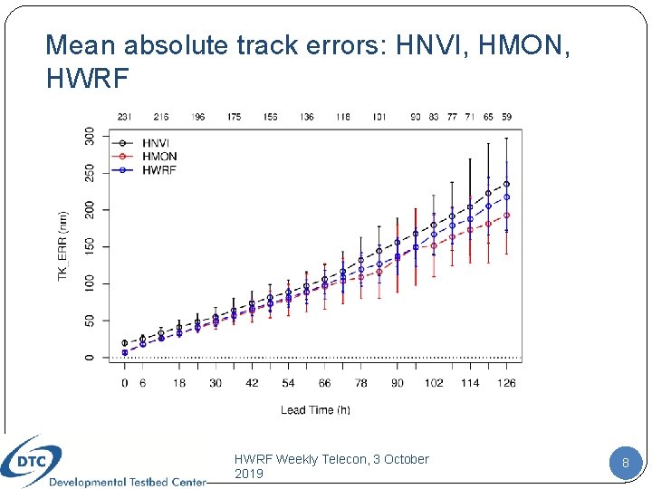
Mean absolute track errors: HNVI, HMON, HWRF Weekly Telecon, 3 October 2019 8

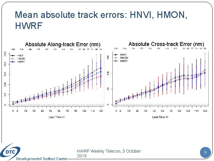
Mean absolute track errors: HNVI, HMON, HWRF Absolute Along-track Error (nm) Absolute Cross-track Error (nm) HWRF Weekly Telecon, 3 October 2019 9

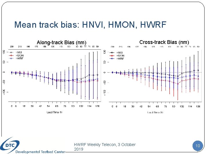
Mean track bias: HNVI, HMON, HWRF Along-track Bias (nm) HWRF Weekly Telecon, 3 October 2019 Cross-track Bias (nm) 10

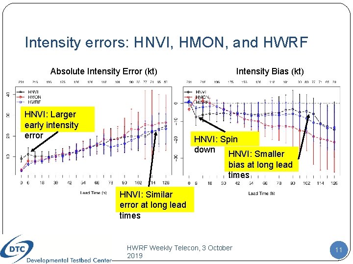
Intensity errors: HNVI, HMON, and HWRF Absolute Intensity Error (kt) HNVI: Larger early intensity error Intensity Bias (kt) HNVI: Spin down HNVI: Smaller bias at long lead times HNVI: Similar error at long lead times HWRF Weekly Telecon, 3 October 2019 11

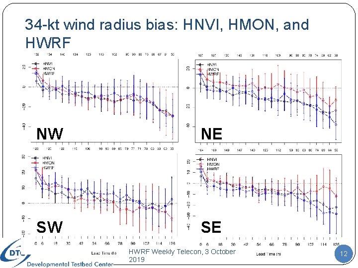
34 -kt wind radius bias: HNVI, HMON, and HWRF NW NE SW SE HWRF Weekly Telecon, 3 October 2019 12

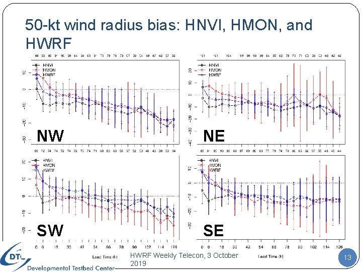
50 -kt wind radius bias: HNVI, HMON, and HWRF NW NE SW SE HWRF Weekly Telecon, 3 October 2019 13

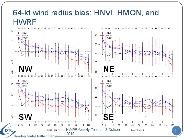
64 -kt wind radius bias: HNVI, HMON, and HWRF NW NE SW SE HWRF Weekly Telecon, 3 October 2019 14

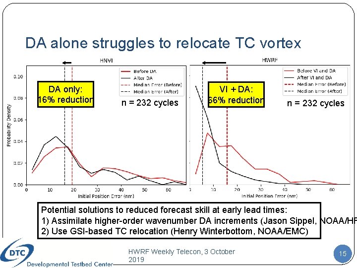
DA alone struggles to relocate TC vortex DA only: 16% reduction n = 232 cycles VI + DA: 66% reduction n = 232 cycles Potential solutions to reduced forecast skill at early lead times: 1) Assimilate higher-order wavenumber DA increments (Jason Sippel, NOAA/HR 2) Use GSI-based TC relocation (Henry Winterbottom, NOAA/EMC) HWRF Weekly Telecon, 3 October 2019 15

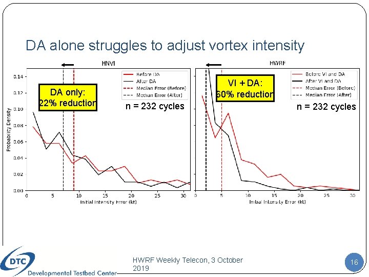
DA alone struggles to adjust vortex intensity DA only: 22% reduction VI + DA: 60% reduction n = 232 cycles HWRF Weekly Telecon, 3 October 2019 n = 232 cycles 16

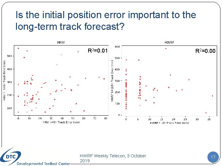
Is the initial position error important to the long-term track forecast? R 2=0. 01 HWRF Weekly Telecon, 3 October 2019 R 2=0. 00 17

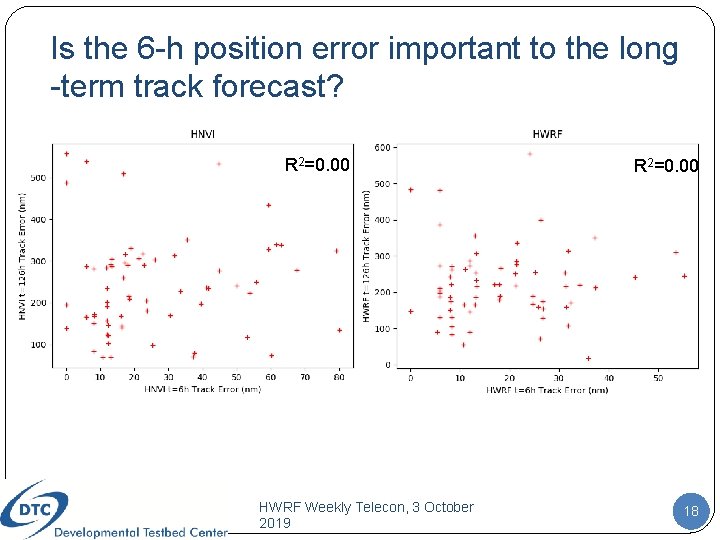
Is the 6 -h position error important to the long -term track forecast? R 2=0. 00 HWRF Weekly Telecon, 3 October 2019 R 2=0. 00 18

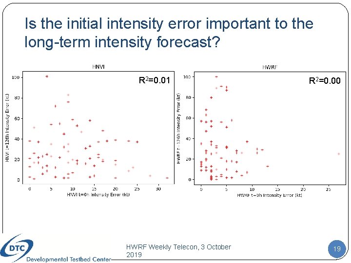
Is the initial intensity error important to the long-term intensity forecast? R 2=0. 01 HWRF Weekly Telecon, 3 October 2019 R 2=0. 00 19

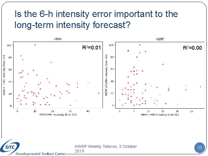
Is the 6 -h intensity error important to the long-term intensity forecast? R 2=0. 01 HWRF Weekly Telecon, 3 October 2019 R 2=0. 00 20

Summary of HNVI results �Small but consistent increase in absolute mean track error across forecast lead times for HNVI �Reduced along-track and cross-track bias �Spin down evident in early forecast lead times (< 24 h) �Later forecast lead times exhibit comparable absolute mean intensity errors and improved intensity bias �Comparable 34 -kt radius bias, degraded 50 -kt radius bias, improved 64 -kt radius bias �HNVI likely would benefit from a GSI-based vortex relocation algorithm that draws data from a synthetic vortex, since GSIHWRF struggles to 3 relocate the vortex Weekly Telecon, October 21 2019 using real obs alone