Ten Year Road and Rail Study For a
- Slides: 23
Ten Year Road and Rail Study For a Six Million TEU Gateway 11/27/2020 Eric Hanson & Christine Wolf, NWSA Planning
Question: Beyond capital expenses for making terminals “big ship ready, ” what off-terminal road and rail infrastructure investment will be needed to support our Strategic Vision for the container business? To answer this question, this study identified: • Off-terminal infrastructure needs • Priority projects addressing these needs • High level project cost estimates 2
Base Conditions and Assumptions • Total NWSA container volume = 6 million TEUs / Year 2026 • Basically a doubling of volume from 2015 • 3 million TEUs each Port area – North and South Harbors • 1. 8 million TEUs intermodal each harbor (on & near-dock) • 1. 2 million TEUs trucks each harbor • “Big Ship Ready” terminals in each harbor 3
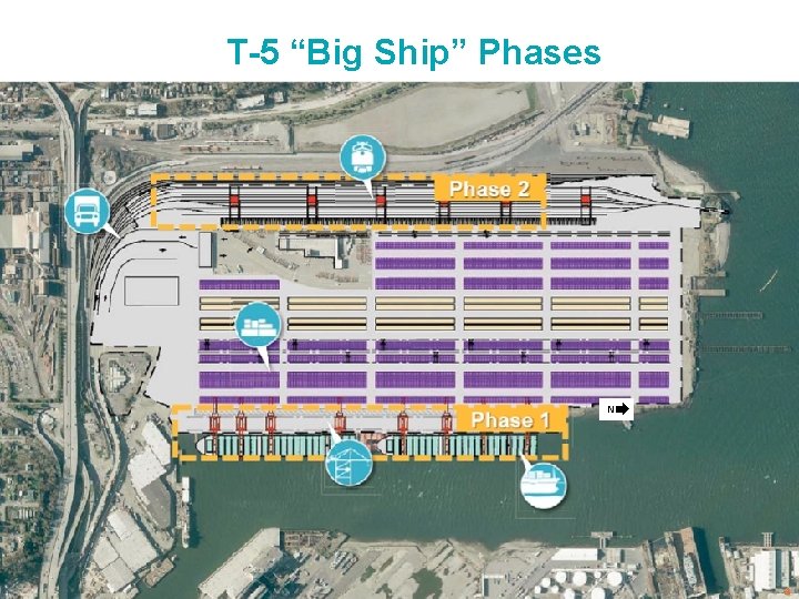
T-5 “Big Ship” Phases N 4
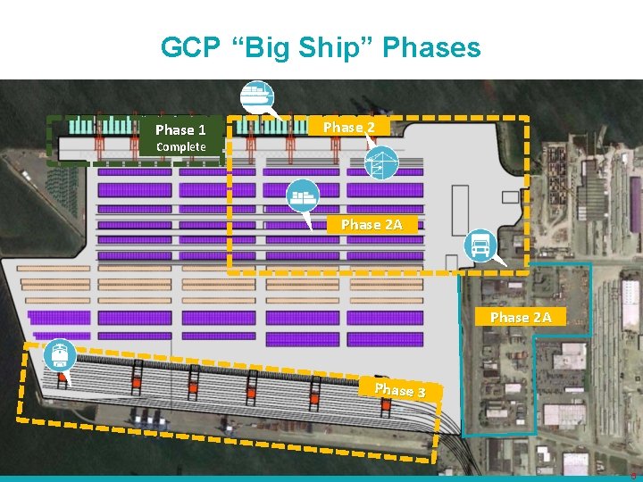
GCP “Big Ship” Phases Phase 1 Phase 2 Complete Phase 2 A Phase 3 5 5
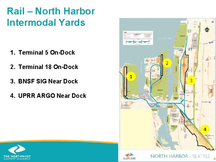
Rail – North Harbor Intermodal Yards 1. Terminal 5 On-Dock 2 2. Terminal 18 On-Dock 3. BNSF SIG Near Dock 1 3 4. UPRR ARGO Near Dock 4 66
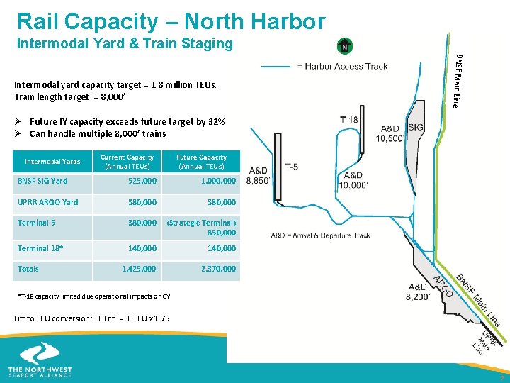
Rail Capacity – North Harbor Intermodal Yard & Train Staging BNSF Main Line Intermodal yard capacity target = 1. 8 million TEUs. Train length target = 8, 000’ Ø Future IY capacity exceeds future target by 32% Ø Can handle multiple 8, 000’ trains Intermodal Yards Current Capacity (Annual TEUs) Future Capacity (Annual TEUs) BNSF SIG Yard 525, 000 1, 000 UPRR ARGO Yard 380, 000 Terminal 5 380, 000 (Strategic Terminal) 850, 000 Terminal 18* 140, 000 1, 425, 000 2, 370, 000 Totals *T-18 capacity limited due operational impacts on CY Lift to TEU conversion: 1 Lift = 1 TEU x 1. 75 7
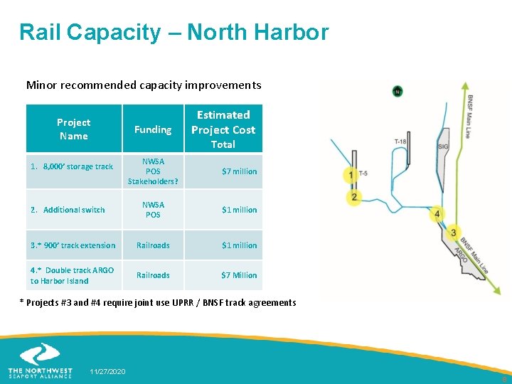
Rail Capacity – North Harbor Minor recommended capacity improvements Project Name Funding Estimated Project Cost Total NWSA POS Stakeholders? $7 million NWSA POS $1 million 3. * 900’ track extension Railroads $1 million 4. * Double track ARGO to Harbor Island Railroads $7 Million 1. 8, 000’ storage track 2. Additional switch * Projects #3 and #4 require joint use UPRR / BNSF track agreements 11/27/2020 8
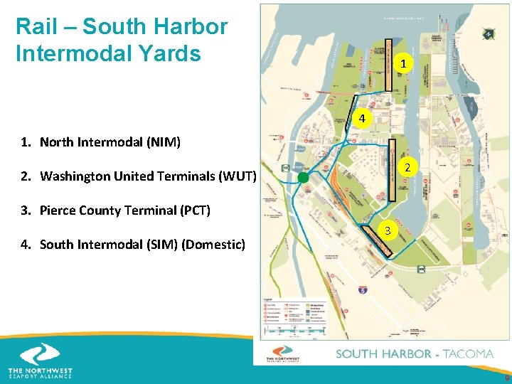
Rail – South Harbor Intermodal Yards 1 4 1. North Intermodal (NIM) 2 2. Washington United Terminals (WUT) 3. Pierce County Terminal (PCT) 4. South Intermodal (SIM) (Domestic) 3 9
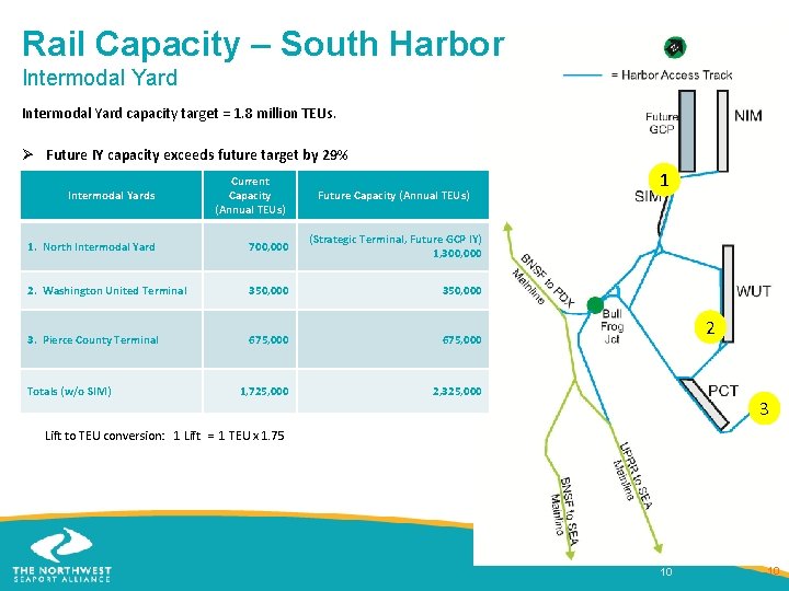
Rail Capacity – South Harbor Intermodal Yard capacity target = 1. 8 million TEUs. Ø Future IY capacity exceeds future target by 29% Intermodal Yards Current Capacity (Annual TEUs) 1. North Intermodal Yard 700, 000 2. Washington United Terminal 350, 000 3. Pierce County Terminal 675, 000 1, 725, 000 2, 325, 000 Totals (w/o SIM) Future Capacity (Annual TEUs) 1 (Strategic Terminal, Future GCP IY) 1, 300, 000 2 3 Lift to TEU conversion: 1 Lift = 1 TEU x 1. 75 10 10
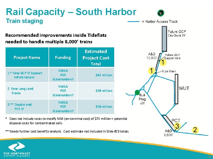
Rail Capacity – South Harbor Train staging Recommended improvements inside Tideflats needed to handle multiple 8, 000’ trains Project Name Funding Estimated Project Cost Total 1. * New GCP IY Support Infrastructure NWSA POT Stakeholders? $45 million 2. New Long Lead Tracks NWSA POT Stakeholders? $20 million 3. ** Double end PCT IY NWSA POT Stakeholders? $50 million * Does not include costs to modify NIM (on-terminal cost) of $70 million + potential disposal costs for contaminated soils ** Needs further cost benefits analysis. Cost estimate not included in Slide #23 totals. 11
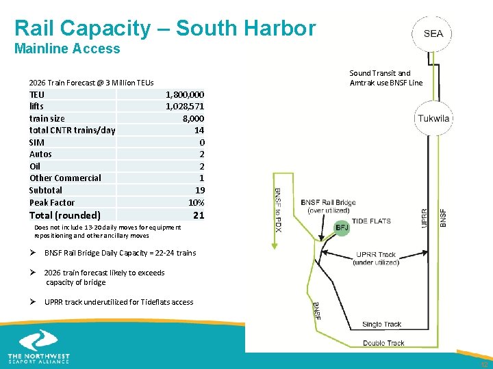
Rail Capacity – South Harbor Mainline Access 2026 Train Forecast @ 3 Million TEUs TEU lifts train size total CNTR trains/day SIM Autos Oil Other Commercial Subtotal Peak Factor Total (rounded) Sound Transit and Amtrak use BNSF Line 1, 800, 000 1, 028, 571 8, 000 14 0 2 2 1 19 10% 21 Does not include 13 -20 daily moves for equipment repositioning and other ancillary moves Ø BNSF Rail Bridge Daily Capacity = 22 -24 trains Ø 2026 train forecast likely to exceeds capacity of bridge Ø UPRR track underutilized for Tideflats access 12
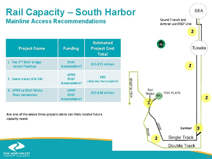
Rail Capacity – South Harbor Sound Transit and Amtrak use BNSF Line Mainline Access Recommendations 2 Funding Estimated Project Cost Total 1. The 2 nd BNSF bridge across Puyallup BNSF Stakeholders? $55 -$75 million 2. Share tracks SEA-TAC UPRR BNSF Stakeholders? Project Name 3. UPRR to BNSF White River connection UPRR BNSF Stakeholders? 2 TBD Likely less than project #1 $25 -$50 million 2 1 Any one of the above three projects alone can likely resolve future capacity needs Sumner 3 2 13
Roadway Methodology – Both Harbors • Screened projects for Port-related freight mobility and congestion mitigation • Defined and assigned three project categories Terminal Access Harbor Mobility Freeway Connection 14
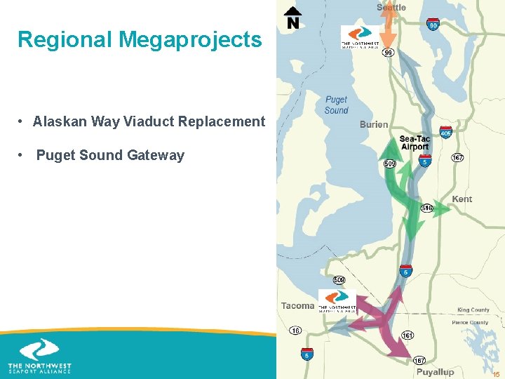
Regional Megaprojects • Alaskan Way Viaduct Replacement • Puget Sound Gateway 15
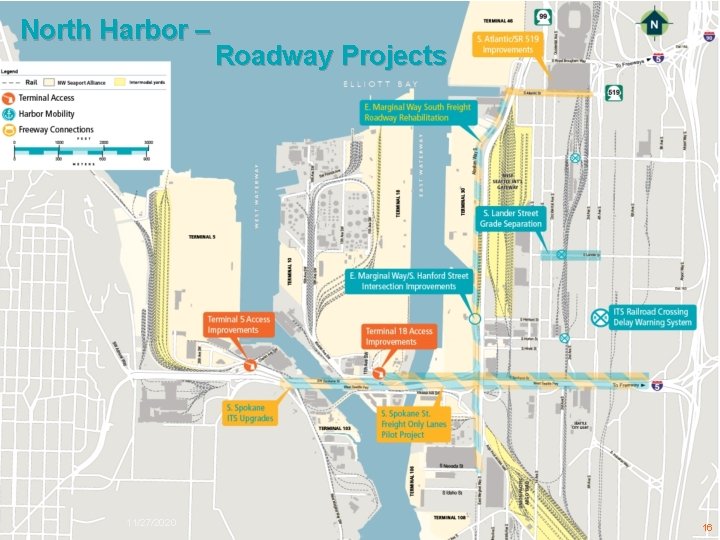
North Harbor – 11/27/2020 Roadway Projects 16
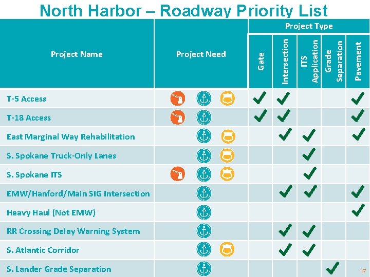
North Harbor – Roadway Priority List Pavement ITS Application Grade Separation Project Need Intersection Project Name Gate Project Type T-5 Access T-18 Access East Marginal Way Rehabilitation S. Spokane Truck-Only Lanes S. Spokane ITS EMW/Hanford/Main SIG Intersection Heavy Haul (Not EMW) RR Crossing Delay Warning System S. Atlantic Corridor S. Lander Grade Separation 17
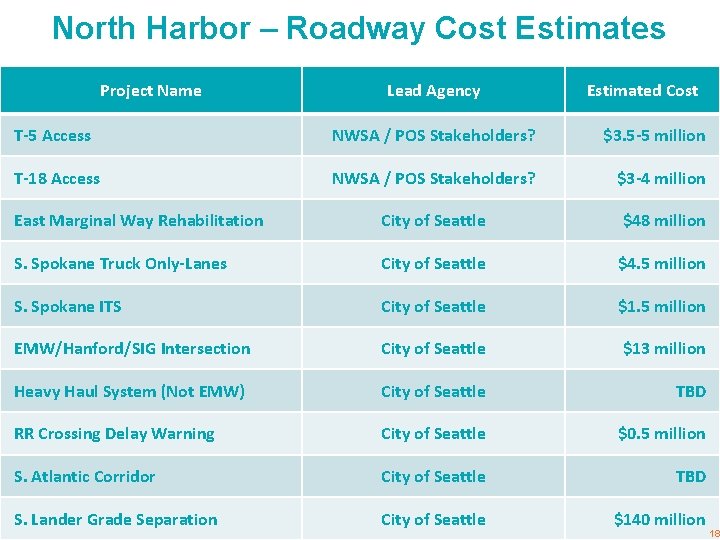
North Harbor – Roadway Cost Estimates Project Name Lead Agency Estimated Cost T-5 Access NWSA / POS Stakeholders? $3. 5 -5 million T-18 Access NWSA / POS Stakeholders? $3 -4 million East Marginal Way Rehabilitation City of Seattle $48 million S. Spokane Truck Only-Lanes City of Seattle $4. 5 million S. Spokane ITS City of Seattle $1. 5 million EMW/Hanford/SIG Intersection City of Seattle $13 million Heavy Haul System (Not EMW) City of Seattle TBD RR Crossing Delay Warning City of Seattle $0. 5 million S. Atlantic Corridor City of Seattle TBD S. Lander Grade Separation City of Seattle $140 million 18
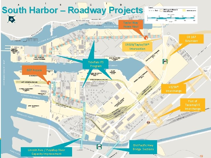
South Harbor – Roadway Projects Taylor Way Heavy Haul SR 167 Extension SR 509/Taylor/54 th Intersection Arterial ITS Tideflats. ITS Program GCP Access I-5/54 th Interchange Port of Tacoma/I-5 Interchange Road System – South Harbor Lincoln Ave. / Puyallup River Capacity Improvement Old Pacific Hwy Bridge Sections 19 19
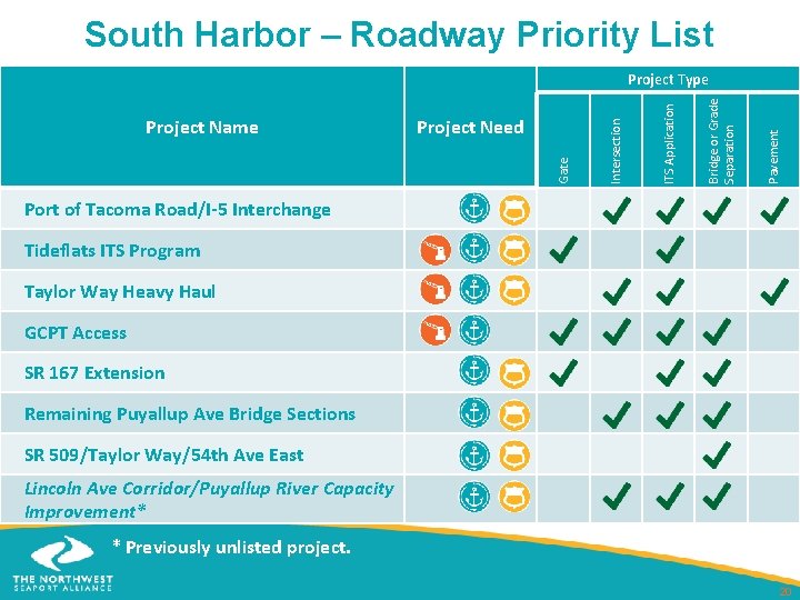
South Harbor – Roadway Priority List Pavement Bridge or Grade Separation ITS Application Project Need Gate Project Name Intersection Project Type Port of Tacoma Road/I-5 Interchange Tideflats ITS Program Taylor Way Heavy Haul GCPT Access SR 167 Extension Remaining Puyallup Ave Bridge Sections SR 509/Taylor Way/54 th Ave East Lincoln Ave Corridor/Puyallup River Capacity Improvement* * Previously unlisted project. 20
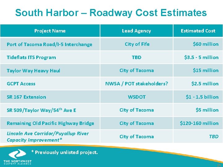
South Harbor – Roadway Cost Estimates Project Name Lead Agency Port of Tacoma Road/I-5 Interchange City of Fife Tideflats ITS Program Taylor Way Heavy Haul GCPT Access SR 167 Extension TBD Estimated Cost $60 million $3. 5 - 5 million City of Tacoma $15 million NWSA / POT stakeholders? $2. 5 million WSDOT $1 - 1. 5 billion SR 509/Taylor Way/54 th Ave E City of Tacoma $5 million Remaining Old Pacific Highway Bridge City of Tacoma $120 -160 million Lincoln Ave Corridor/Puyallup River Capacity Improvement* City of Tacoma TBD * Previously unlisted project. 21
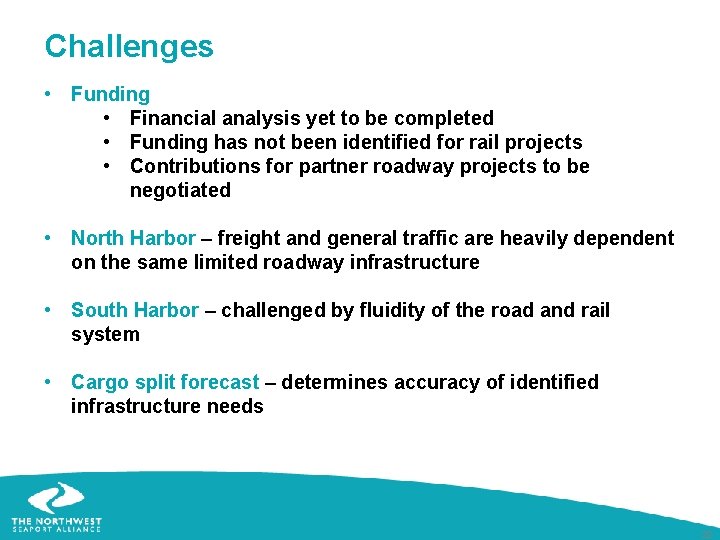
Challenges • Funding • Financial analysis yet to be completed • Funding has not been identified for rail projects • Contributions for partner roadway projects to be negotiated • North Harbor – freight and general traffic are heavily dependent on the same limited roadway infrastructure • South Harbor – challenged by fluidity of the road and rail system • Cargo split forecast – determines accuracy of identified infrastructure needs 22
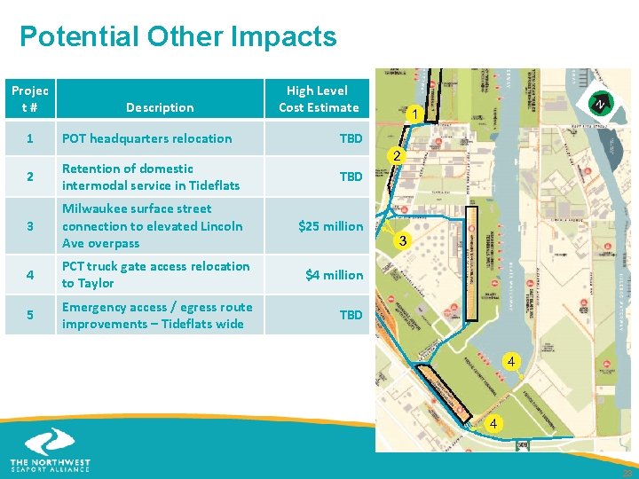
Potential Other Impacts Projec t # Description High Level Cost Estimate 1 POT headquarters relocation TBD 2 Retention of domestic intermodal service in Tideflats TBD 3 Milwaukee surface street connection to elevated Lincoln Ave overpass $25 million 4 PCT truck gate access relocation to Taylor $4 million 5 Emergency access / egress route improvements – Tideflats wide TBD 23