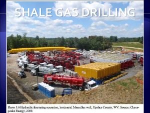
Shale Gas Drilling Deep Creek watershed SURFACE DRILLING


- Slides: 23

Shale Gas Drilling Deep Creek watershed SURFACE DRILLING CONSTRAINTS SPATIAL ANALYSIS EXERCISE

Current Regulation – Deep Creek Watershed Zoning Ordinance • 2000’ from the high water elevation line of Deep Creek Lake, measured at 2, 462 feet above sea level

Current Regulation – Deep Creek Watershed Zoning Ordinance • 1, 000 feet from the property line of any lot not owned or leased to the entity responsible for the gas drilling, removal or storage operation. • Moving target, so difficult to predict. • Currently 3 properties have active leases, all in the area of the Mc. Henry cove.

Currently Leased Properties • As these properties are surrounded by unleased properties they would need to apply a 1000 foot inner setback around their property lines before they could locate a surface drilling operation. • One property is already in a restricted area • The other two properties are not large enough to accommodate both the setback and a drilling operation. • If drilling were allowed today, based on the current leases, drilling could not occur in the watershed. • As this situation can change, it’s necessary to look at the restrictions imposed by proposed state regulations

Proposed Regulation – Appendix A: Location Restrictions and Setbacks • Restriction #3: No well pad may be permitted on land with a slope, before grading, of greater than 15 percent.

Proposed Regulation – Appendix A: Location Restrictions and Setbacks • Restriction #5 b: the edge of disturbance of a well pad shall be at least 450 feet from the edge of an aquatic habitat. • Aquatic habitat is listed in Appendix D of the same document as streams, rivers, seeps, springs, wetlands, lakes, ponds, reservoirs and the 100 year floodplain.

Applying the buffer • 450 foot buffer on aquatic habitat

Proposed Regulation – Appendix A: Location Restrictions and Setbacks • Restriction #5 c: The edge of disturbance of a well pad shall be at least 600 feet from special conservation areas • Appendix D defines these as wildlands and irreplaceable natural areas (INA) • There are no wildlands in the Deep Creek watershed • INAs are Tier 1 & 2 areas in the State Bio. Net Conservation Diversity Map

Applying the buffer • 600 feet from Tier 1 & 2 Bio. Net Conservation Areas

What about land in currently in a conservation program? • According to DNR/MDE sources these areas will most likely be prohibited from any surface drilling but no setbacks will be applied • These lands include lands owned by the Nature Conservancy, Agricultural Preservation easements or MET easements

Applying the restriction • Properties are classified as restricted but no setback is applied

Unleased Property? • If one could make the assumption that if any property will remain unleased, it will most likely be those already protected by conservation easements, according to Deep Creek Watershed zoning regulations, that buffer will become 1000 feet

Proposed Regulation – Appendix A: Location Restrictions and Setbacks • Restriction #5 d: The edge of disturbance of a well pad shall be at least 300 feet from a cultural or historic site, State or Federal parks, trails, wildlife management areas, wild scenic rivers and scenic byways. • Appendix D lists only those historic sites on the National Registry • There are no National Registry historic sites, federal parks or wildlife management areas within Deep Creek Watershed • Only DNR Trails were mapped • Wild scenic rivers were included in the 450 foot setback of aquatic habitat • State parks, trails and scenic byways are shown

Applying the buffer • 300 foot buffer from state parks and scenic byways

State Park Unleased? • Note state land state parks are different areas. State parks are all state land but not all state land is a state park. • The restriction applies only to those properties under the Maryland Park Service not the Maryland Forest Service. • If one assumes the state parks will remain unleased, the buffer will become 1000 feet.

Proposed Regulation – Appendix A: Location Restrictions and Setbacks • Restriction #5 e: The edge of disturbance of a well pad shall be at least 1000 feet of known caves. • There are no known, mapped caves in the DC watershed according to DNR cave data. • Restriction #5 f: The edge of disturbance of a well pad shall be at least 750 feet on the downdip side of a limestone outcrop. • This cannot be mapped at this time, for though Karst shows where outcrops could be, it doesn’t show where they are.

Proposed Regulation – Appendix A: Location Restrictions and Setbacks • Restriction #5 g: The edge of disturbance of a well pad shall be at least 1000 feet from any occupied building, school or church. • County addresses are assigned to residences and businesses. No structures where people do not live, work or regularly congregate should be assigned an address. • Addresses are given to structures and not lots, therefore they are located in the center of building footprints. • If the State defines ‘occupied buildings’ to include seasonal or rental homes, all addresses in the watershed would be included as occupied buildings.

Applying the buffer • 1000 feet from occupied buildings, schools and churches

Proposed Regulation – Appendix A: Location Restrictions and Setbacks • Restriction #5 h: The edge of disturbance of a well pad shall be at least 1000 feet of a wellhead protection area or a source water assessment area for a public water system for which a Source Water Protection Area (SWPA) has been delineated… • There is one SWPA in Deep Creek watershed.

Applying the buffer • 1000 feet from a SWPA

Proposed Regulation – Appendix A: Location Restrictions and Setbacks • Restriction #5 k: The edge of disturbance of a well pad shall be at least 2000 feet from a private drinking water well. • Since all addresses are located in the building footprint then the assumption is made that their location is close to the location of the well. • All addresses not served public water would qualify for this setback. • There are two public water systems in Deep Creek watershed – Mc. Henry and Thayerville.

Applying the buffer • 2000 feet from all addresses not served public water

Points of note • This analysis did not include historic oil or gas wells, or other listed restrictions that could not be mapped. • Restriction #7 states that the ‘setback restrictions for well pads also apply to all gas development activities that result in permanent surface alteration…’ The assumption can be made that these restrictions also apply to compressor stations and/or storage facilities. • Restriction #5 a calls for all well pads to be 1000 foot from the boundary of the property on which the well is to be drilled. • As a consequence the areas left in the map must meet that restriction and only the property owned by Rock Lodge Trust meets that requirement.
 Dry creek experimental watershed
 Rice creek watershed
 Big darby creek watershed
 Bear creek watershed
 Shale gas
 Shale gas
 Marcellus shale royalty calculator
 Marcellus and utica shale map
 Shistosity
 Limestone sandstone shale
 Shale planning
 Shale outcrop
 Shale island
 Shale island
 Biochemical sedimentary rocks
 Clastic sedimentary rocks
 What is a rock's favorite cereal
 Where can i find this image
 Coquina
 Rock cycle def
 Acorn worm
 Deep asleep deep asleep it lies
 Deep forest: towards an alternative to deep neural networks
 深哉深哉耶穌的愛
