Prospecting for atmospheric energy for autonomous flying machines


")
")
 by CIRPAS (Center for Interdisciplinary Remotely")
 2 m. J")

 – OLEs –")


 FL • Purpose was to look ahead of")


 0 4 8 12 16 20 24 28 32 36 2000")
 = 8. 9 m/s From")


- Slides: 27
Prospecting for atmospheric energy for autonomous flying machines G. D. Emmitt and C. O'Handley Simpson Weather Associates Lidar Working Group Meeting Snowmass July 17 – 20 2007
Acknowledgements • DARPA funding • Dr. James Hubbard, National Institute of Aerospace (PI for Sky. Walker) • Navy’s Center for Interdisciplinary Remotely Piloted Aircraft Studies (Twin Otter aircraft and Doppler wind lidar)
Objectives • Fly airborne DWL to explore the feasibility of using Doppler lidar to autonomously prospect for vertical motions and shear within reasonable proximity of an unpiloted aircraft (below 3 km) • Develop a set of Atmospheric Energy Prospecting Algorithms (AEPAs) • Develop DWL instrument specifications for future UAVs. “Whisker” class DWLs could sense nearby vertical air motions that would enhance probability of intercepts and thus increase mission duration
Strategy • Conduct airborne experiments using the Navy’s Twin Otter Doppler Wind Lidar (TODWL) system to collect data to: – Identify the DWL detectable signatures of vertical structures (thermals and atmospheric waves) and horizontal wind shear observed ahead of the aircraft at or near flight level; – Determine the vertical extent of vertical motion structures that can be reached from the current aircraft position; – Rank multiple coincident vertical motion structures based upon risk/benefit metrics.
The TODWL system A CIRPAS instrument (Twin Otter Doppler Wind Lidar)
Background • TODWL has been operated (since 2002) by CIRPAS (Center for Interdisciplinary Remotely Piloted Aircraft Studies), a part of the Naval Postgraduate School, Monterey, CA. Emmitt is the TODWL PI. • Used by NOAA for investigating lidar performance over the ocean in planning for a future space-based DWL • Used by USArmy for studies of UAV wind profiling in complex terrain and urban areas. • Used by Navy to conduct MBL research; recently added the Smart Towed Platform
The instrument • • 2µm coherent detection (CTI MAG 1 A) 2 m. J ; 500 Hz 10 cm two axis scanner, side door mounted GUI with realtime instrument control and data display • Range: . 3 – 21 km depending upon aerosols • Accuracy: <. 10 m/s in three components • Weight: 700 lb Power: 700 W
Particle probes STV TODWL scanner Surface Temperature Sensor
Targets for AEPAs • Thermal like – Thermals (flat land slope) – OLEs – Cloud updrafts • Obstacle flows – Orographic upslope currents • Gravity waves – Mountain waves • Lower tropospheric jets – Shear in general
Prospecting Flights October ‘ 06 & April ’ 07 Monterey, CA • 20 hours of flight time • Explored several strategies for scanning lidar (raster, step stare, forward conical) • Flights targeted ground rooted thermals, Organized Large Eddies (OLEs), orographic waves, low level jets and cloud updrafts
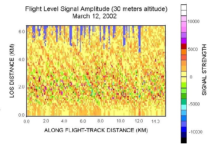
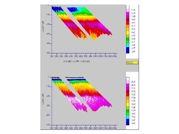
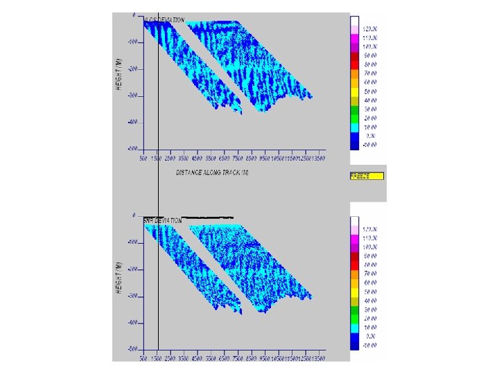
Prospecting for OLEs TODWL
~1500 m ~400 m
Salinas Valley 500 feet over Salinas Valley floor Monterey Mountains Over Salinas Airport
Inputs to Flight Planning Cap on thermals
Flight over valley: 150 m (~500’) FL • Purpose was to look ahead of the aircraft for convergence zones that may portend coherent vertical motions and shear layers useful for “dynamic soaring”. • Scanning strategy was to scan beam on a plane oriented ~ 5 degrees below the flight level; scanning was to right side of the aircraft and subtended ~ 10 degrees.
High aspect ratio vertical features Ground intercept Not so well organized or persistent features
4 m/s Example of forward sweeping scan of velocity and backscatter Vertical velocity of aircraft measured by INS on Twin Otter Aerosol loading appears greatest in upward moving features XZ slice w/ x being along track Expect (ideally) that upward motion would occur near switch from positive to negative velocity deviations
WIND SPEED (M/S) 0 4 8 12 16 20 24 28 32 36 2000 HEIGHT (M) 1600 WIND PROFILES, APRIL 17 2007 BLACK: WIND DIRECTION RED: WIND SPEED SOLID: AFTERNOON FLT DASHED: EVENING FLT 1200 800 400 Salinas Valley (205 m) 0 0 90 180 WIND DIRECTION (DEG) 270 360
Dynamic Soaring For the albatross, the minimum V(10 m) = 8. 9 m/s From Gottfried Sachs (2005)
Salinas Valley Centerline
Mountain Waves? 1944 PDT 17 April 2007 near King City, CA
Atmospheric Energy Prospecting T, RH & Wind soundings In-flight DWL Prospecting Scans Diagnostic & Predictive Models Likelihood of significant and useable atmospheric dynamics Feature Identification Opportunity Ranking (Push-broom & Adaptive) Target Selection Platform Navigation Update Pre-flight activities In- flight activities AIFC Target Rapid Update Platform Adaptive Configuration
Summary • The continuous or random raster scans are the best options for the detection and characterization of vertical velocity features • The vertical velocities inferred from the LOS convergence/divergence observations appear to be reasonable and useful • The correlation of aerosol loading and vertical motion may be useful. However, the interpretation of this relationship requires further study. • Airborne prospecting for clear air vertical motion features appears very feasible and may easily be extended to clouds, waves and shear situations. • In November, TODWL flights will focus on nocturnal atmospheric advantages: gravity waves, low level jets (dynamic soaring) and cloud updrafts.