Multihazard prone coasts Where are we now where

 3.")


, nuclear meltdown")


- Slides: 18
Multi-hazard prone coasts Where are we now & where to from here? Deirdre E. Hart 1, Sebastian J. Pitman 1, Do-Seong Byun 2 1 UC; 2 Korea Hydrographic & Oceanographic Agency, Busan
Outline 1. Multi-hazards defined, examples, CES 2. Research project (with NZCS PDA support) 3. Concluding remarks, questions & suggestions, selected references
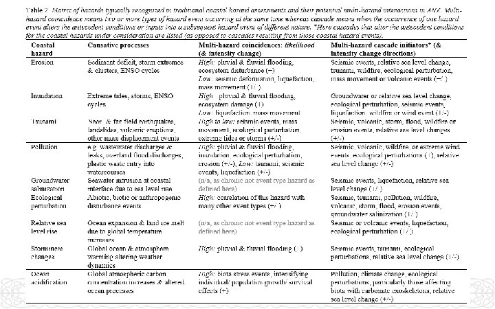
Multi-hazards When 2 or more hazard types interact in space & time, so the sum of their interactions produces different effects to the combined effects of the same hazards operating separately.
Coastal example - Kaikōura November 2016, earthquake & tsunami, subsequent heavy rain & catchment mass movement, plus dam failure hazards Stuff
Multi-hazards Sendai Framework 1 st priority for disaster risk reduction = better “understanding of disaster risk”, via “comprehensive surveys on multihazard disaster risks & the development of regional disaster risk assessments & maps, including climate change scenarios” - global & regional.
Coastal example - Fox March 2019 extreme rainfall, river flood, landfill disintegration & coastal pollution Stuff
Coastal example – East Japan March 2011 earthquake, tsunami (incl. wall failure), nuclear meltdown
Coastal example – Indian Ocean December 2004 tsunami: beach rotation heightened island exposure to monsoon erosion for several subsequent years MH Cascade occurrence of one hazard event alters antecedent conditions or inputs into a subsequent hazard event of a different type MH Coincidence 2+ types of hazard event occurring simultaneously
Coastal example – Ōtautahi Canterbury Earthquake Sequence e. g. Taylors Mistake Feb 14, 2016
CES effects - morphology, sediments, ecology Open-coast sand beaches • Minor displacement (10 s cm), little lasting effect on open-coast beaches/ ecosystems (Hart & Gomez, 2013) • Temporary pulse of fine sand/silt fraction in beaches (+30% 4 months post-quake, gone in <2 y, Taylor 2013) • Temporary dune toe scarp along 6. 5 km sandy open coast first winter post-quake, profile recovered <1 y • [NB geological history of spit and dune growth in response to large S. Alps quakes & sediment pulses here] Coastal hydrosystems • Avon-Heathcote estuary bed deformed (66% up, 33% down), -20% tidal prism capacity (Measures et al. , 2011) • Intertidal saltmarsh coastal squeeze where backshore hard or re-contoured (Campbell et al. , 2013) • Loss of seabed vegetation, increased ‘very soft mud/sand’ type habitat (Hollever & Bolton-Ritchie, 2016) • Salt wedge upstream migration in AH small feeder rivers, but not in large Waimakariri River • Temporary sediment smothering & long-term upstream migration of AH benthic communities (Ecan, 2011) • Brooklands Lagoon bed subsidence, saltmarsh migration & inundation of adjacent supra-tidal areas
CES effects – coastal infrastructure, amenity Selected coastal suburb, infrastructure, & amenity effects • Widespread wastewater pipe damage, leaks into groundwater & storm water. • Wastewater repair phase untreated discharges to rivers, estuary & coasts, beach swimming closed for 1 y • Roads closures (esp. bridges/ shore edges), from temporary to permanent, hampering emergency & recovery work, & limiting bay-to-city connectivity (Giovinazzi et al. , 2011) • Liquefaction subsidence → daily high-tide flooding of areas previously only affected by extreme events • Widespread lowland subsidence rendered pre-quake tsunami, flood & coastal hazard assessments obsolete, with updated reports showing significant increases in exposures • Areas deemed damaged beyond economic repair predom. riverside/ coastal→ managed retreat • Extensive port damage lasting several years • Port rebuild/ extension fast-tracked 10 -ha reclamation using 1 M tons building rubble, with ~42 K tons uncleaned rubble dumped into harbor without a boom during civil emergency phase (Allen et al. , 2014)
Coastal multi-hazards assessment project Aim to explore the intersection between multi-hazard interactions & coastal hazards, including sea level & climate changes. • To what extent is there consideration of feedback & cascades between the different types of hazard affecting coastal places & coastal resources? • Are coastal & ‘other’ hazard coincidences in space/ time considered? If so, how? • How can the risks & effects of multiple & multi-hazards be treated quantitatively?
Multi-hazards theory Gill & Malamud 2014
Why multi-hazards need to be considered in coastal assessments Many coastal settlements are inherently exposed to multi-hazards. Pacific Rim represents one of the most multi-hazard prone regions on Earth. Traditional (non-MH) hazard analyses can both under- and over-estimate hazard effects in coastal settlements, leading to misplaced priorities & undiscovered opportunities to increase adaptation, resilience & sustainability.
Questions, input & suggestions deirdre. hart@canterbury. ac. nz Thanks to multi-hazard colleagues & pioneers (including Sonia Giovinazzi, Craig Davis, Chris Gomez, Kerryn Hawke, Derek Todd, CCC) & to inspiring graduate students (including Emma Kelland, Blair Campbell, Gareth Taylor & Kate Mac. Donald) working at the coastal quake ‘coal face’
Selected references • Gill and Malamud, 2014. Reviewing and visualizing the interactions of natural hazards. Reviews of Geophysics, 52(4), 680 -722. • Hart and Hawke, 2016. Multi-hazard flooding interactions in the Ōpāwaho Heathcote Catchment, Chch, NZ. UC Report prepared for CCC and Jacobs, 45 p. • Hart et al. , 2018. Enhancing resilience by altering our approach to earthquake and flooding assessment: multi-hazards. 16 th European Conference on Earthquake Engineering, 18 -21 Jun 2018, (12164), 13 p. • Todd et al. , 2017. Multi-hazard analysis: Gap analysis report. Prepared for CCC by Jacobs, Univ. Canterbury, Beca, and HR Wallingford, 153 p. • UNISDR, United Nations International Strategy for Disaster Reduction, 2015. Sendai Framework for Disaster Risk Reduction 2015– 2030.
Abstract Since 2010, New Zealand has experienced several major ‘coastal quake’ disruptions to coastal environments. Natural and built components of coastal cities and rural centres have been affected, including in Christchurch, Kaikoura and Wellington. Over this time we have also adopted the second generation New Zealand Coastal Policy Statement (2010) and started to employ new Government guidance regarding Coastal Hazards and Climate Change (2017). Questions arising include: ‘Where are we now’ in terms of processing and integrating these complex experiences? ; and What more is needed to inform future directions? This paper begins by highlighting some of the temporary and lasting effects of the Canterbury, Kaikoura and Wellington coastal quake experiences for open coast, hydrosystem and Lifeline linkage settings. This summary is used to reflect on ways of viewing coastal resources and hazards. Secondly, we explore the potential and limitations of current multi-hazards science for translating coastal quake lessons into improved hazard assessment and management practices. Case study analyses of coastal city flooding and erosion are illustrated. Key multihazard questions posed are: How can one kind of event alter the antecedent conditions of another kind of event? ; What might be different if two kinds of event occur together, and how likely are they to occur together? ; and How can multi-hazard interactions be represented in hazard assessments in a New Zealand context? This paper suggests that reflecting upon our experiences of ‘coastal quake’ interactions, including the dynamics of response, recovery and rebuild phases, could help transform our approach to planning and managing coastal settlements, in particular for climate change adaptation. Key take-home messages include the importance of thinking through how elements of the coastal environment intersect with wider systems beyond our expertise. Also key is to know your data and its limits. Multi-hazards thinking reminds us that in coastal systems interactions are key; experts are learners; and it is crucial to remember the ‘why’ when investigating a specific coastal issue.