Movement of the Earthquakes and Seismic Waves Part
")

 – Is to be completed independently –")


 Waves: • Secondary waves, or S waves, are")


- Slides: 26
Movement of the Earthquakes and Seismic Waves (Part 2)
-Turn to the beginning of Chapter 14 Section 2 which starts on page 467. -Take a few minutes to flip through sections 2 & 3 looking at the diagrams and reading the caption that accompanies each.
Writing in Science: News Report (pg. 473) – Is to be completed independently – Should be at least 1 paragraph (NO LESS THAN 8 SENTENCES) – Will be graded for spelling, grammar and content – Will be counted as a QUIZ GRADE – Due on FRIDAY, APRIL 8 th
Earthquakes and Seismic Waves • Every day, worldwide there are several thousand earthquakes. • An earthquake is the shaking and trembling that results from the movement of rock beneath Earth’s surface.
Earthquakes and Seismic Waves • Plate movements cause stress in Earth’s crust, adding energy to the rocks and forming faults. • Stress increases along the fault until the rock breaks, causing an earthquake. • In seconds the earthquake releases an enormous amount of stored energy.
Earthquakes and Seismic Waves • Most earthquakes begin in the lithosphere within about 100 km of Earth’s surface. • The focus is the area beneath Earth’s surface where the rock that is under stress breaks, triggering an earthquake.
Earthquakes and Seismic Waves • The point on the surface directly above the focus is called the epicenter. • During an earthquake, the most violent shaking is found at the epicenter because seismic waves reach the epicenter first.
Types of Seismic Waves • During an earthquake, seismic waves race out from the focus in all directions. • Seismic waves carry energy from an earthquake away from the focus, through Earth's interior, and across the surface.
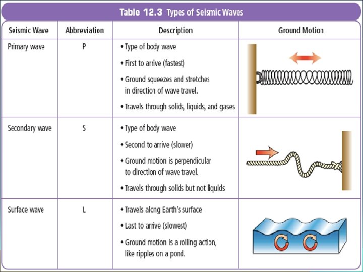
Types of Seismic Waves • There are three main categories of earthquake waves: primary waves (P waves), secondary waves (S waves), and surface waves. • P waves and S waves originate from the earthquake's focus. • When these waves reach the epicenter, surface waves develop.
Types of Seismic Waves Primary Waves: • The first waves to arrive are primary waves, or P waves, and are generally felt as a jolt or thump. • P waves are seismic longitudinal waves (like a slinky) that compress and expand the ground like an accordion.
Types of Seismic Waves Secondary (Shear) Waves: • Secondary waves, or S waves, are slower and stronger than P waves and arrive after P waves. • S waves are seismic transverse waves that vibrate from side to side as well as up and down, shaking the ground back and forth. • Unlike P waves that can move through both solids and liquids, S waves cannot move through liquids.
Types of Seismic Waves Surface Waves: • When P waves and S waves reach the surface, some of them become surface waves. • Surface waves move more slowly than P and S waves, but can produce more severe ground movements. • Some surface waves make the ground roll like ocean waves. Others shake buildings from side to side.
Measuring Earthquakes • Three commonly used methods for measuring earthquakes are the Mercalli scale, the Richter scale, and the moment magnitude scale.
Measuring Earthquakes: The Mercalli Scale • The Mercalli scale was developed to rate earthquakes according to the level of damage at a given place. • The Mercalli scale uses roman numerals to rank earthquakes by how much damage they cause.
Measuring Earthquakes: The Richter Scale • An earthquake’s magnitude is a number that geologists assign to an earthquake based on the earthquake’s size. • Magnitude is measured by measuring the seismic waves and fault movement that occur during an earthquake.
Measuring Earthquakes: The Richter Scale • The Richter scale is a rating of an earthquake’s magnitude based on the size of the earthquake’s seismic waves. • The seismic waves are measured by a seismograph, which is a machine that records and measures earthquake waves. • The Richter scale provides accurate measurements for nearby earthquakes, but does not work well for large or distant quakes.
Measuring Earthquakes: The Moment Magnitude Scale • Geologists today use the moment magnitude scale, a rating system that estimates the total energy released by an earthquake. • This scale can be used to rate earthquakes of all sizes near or far. • You may hear news reports that mention the Richter scale, but the number quoted is almost always the moment magnitude of the quake.
Measuring Earthquakes: The Moment Magnitude Scale • To rate an earthquake using the moment magnitude scale, the geologists first study data from seismographs. • The data show what kind of seismic waves were produced and how strong they were. • The data also help geologists infer how much movement occurred along the fault and the strength of the rocks that broke when the fault slipped. • Geologists use all this information to rate the quake on the moment magnitude scale.
Measuring Earthquakes: Comparing Magnitudes • An earthquake’s magnitude tells geologists how much energy was released by the earthquake. • Each one-point increase in magnitude represents the release of roughly 32 times more energy. • For example, a magnitude 6 earthquake releases 32 times as much energy as a magnitude 5 and about 1, 000 times as much as a magnitude 4 quake.
Fill in the table. Use the 1 st paragraph on page 472 to help you. MAGNITUDE QUAKE DESCRIPTION Below 3 People scarcely notice Below 5 Small and cause little damage Between 5 & 6 Can cause moderate damage Above 6 Can cause great damage 8 or above Most powerful, are rare Above 9 Chile in 1960 and Alaska in 1964
3. 0 Magnitude
5. 0 Magnitude
8. 0 Magnitude
Locating the Epicenter • Geologists use seismic waves to locate an earthquake’s epicenter. • Seismic waves travel at different speeds. • P waves arrive at a seismograph first with S waves following close behind. • The farther away an earthquake is from the epicenter, the greater the time between the arrival of the P waves and the S waves.
Locating the Epicenter: Triangulation • Geologists draw at least three circles using data from different seismographs all over the world. • The center of each circle is the particular seismograph’s location. • The radius of each circle is the distance from that seismograph to the epicenter. • Where three circle intersect is the location of the epicenter.