Institute of Photogrammetry and Geo Information Section 7
- Slides: 38
Institute of Photogrammetry and Geo. Information Section 7 Orthoimage generation and object extraction (mainly roads and buildings) Emmanuel Baltsavias ISPRS Technical Commission I Symposium “From Sensors To Imagery”, Paris – Marne la Vallée, France, 3 -6 July 2006
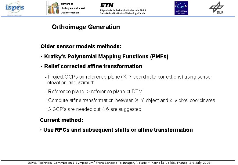
Institute of Photogrammetry and Geo. Information Orthoimage Generation Older sensor models methods: • Kratky’s Polynomial Mapping Functions (PMFs) • Relief corrected affine transformation - Project GCPs on reference plane (X, Y coordinate corrections) using sensor elevation and azimuth - Reference plane -> reference plane of DTM - Compute affine transformation between X, Y object and x, y pixel coordinates - 3 GCP’s are needed but 4 -6 are suggested Current method: • Use RPCs and subsequent shifts or affine transformation ISPRS Technical Commission I Symposium “From Sensors To Imagery”, Paris – Marne la Vallée, France, 3 -6 July 2006
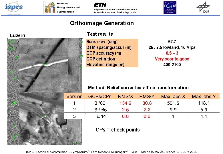
Institute of Photogrammetry and Geo. Information Orthoimage Generation Luzern Test results Method: Relief corrected affine transformation CPs = check points ISPRS Technical Commission I Symposium “From Sensors To Imagery”, Paris – Marne la Vallée, France, 3 -6 July 2006
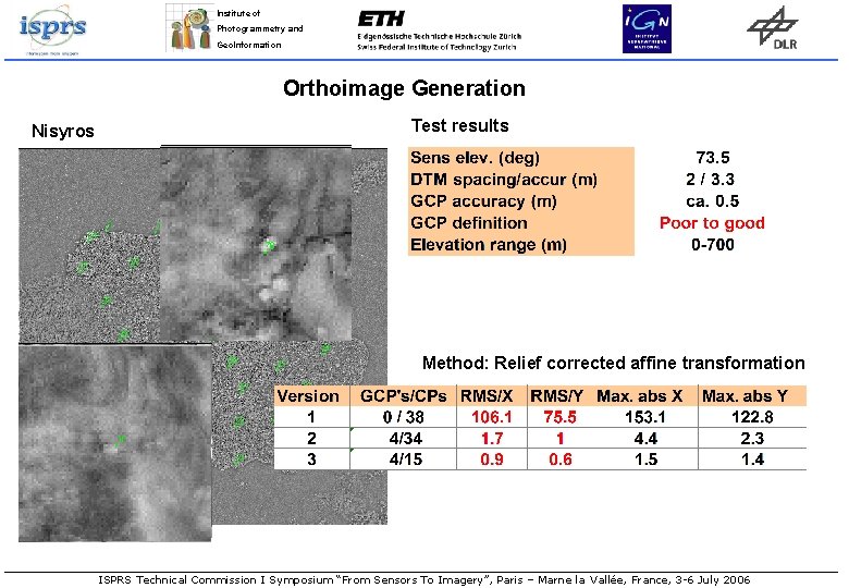
Institute of Photogrammetry and Geo. Information Orthoimage Generation Nisyros Test results Method: Relief corrected affine transformation ISPRS Technical Commission I Symposium “From Sensors To Imagery”, Paris – Marne la Vallée, France, 3 -6 July 2006
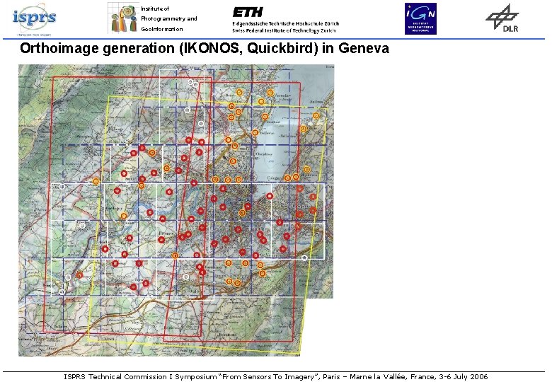
Institute of Photogrammetry and Geo. Information Orthoimage generation (IKONOS, Quickbird) in Geneva Input data 2 IKONOS Geo images (IKONOS-West / IKONOS-East) 1 Basic QUICKBIRD Image Orthoimages (for acquisition of GCPs): OP-DIAE: Digital Orthos of Canton Geneva (25 cm pixel size, 0. 5 m planimetric RMS) Swissimage: Digital Orthos of Switzerland of Swisstopo (50 cm pixel size, 1 m planimetric RMS) DTMs: DTM-AV (from airborne laser scanning): 1 m grid spacing, 0. 5 m height RMS DHM 25 of Swisstopo (from digitised contours): 25 m grid spacing, 1. 5 -2 m height RMS Measurement of GCPs with ellipse fit and line intersection. Image orientation with various sensor models. RPCs with subsequent affine transformation used for orthoimage generation. ISPRS Technical Commission I Symposium “From Sensors To Imagery”, Paris – Marne la Vallée, France, 3 -6 July 2006
Institute of Photogrammetry and Geo. Information Orthoimage generation (IKONOS, Quickbird) in Geneva ISPRS Technical Commission I Symposium “From Sensors To Imagery”, Paris – Marne la Vallée, France, 3 -6 July 2006
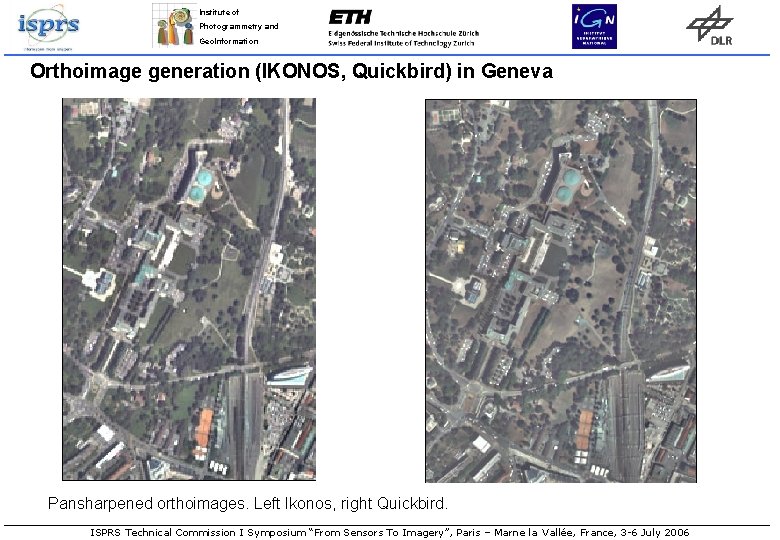
Institute of Photogrammetry and Geo. Information Orthoimage generation (IKONOS, Quickbird) in Geneva Pansharpened orthoimages. Left Ikonos, right Quickbird. ISPRS Technical Commission I Symposium “From Sensors To Imagery”, Paris – Marne la Vallée, France, 3 -6 July 2006
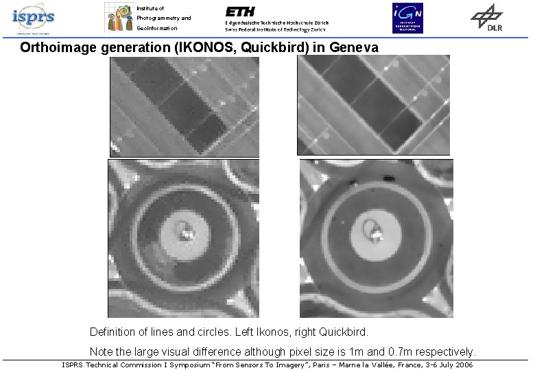
Institute of Photogrammetry and Geo. Information Orthoimage generation (IKONOS, Quickbird) in Geneva Definition of lines and circles. Left Ikonos, right Quickbird. Note the large visual difference although pixel size is 1 m and 0. 7 m respectively. ISPRS Technical Commission I Symposium “From Sensors To Imagery”, Paris – Marne la Vallée, France, 3 -6 July 2006
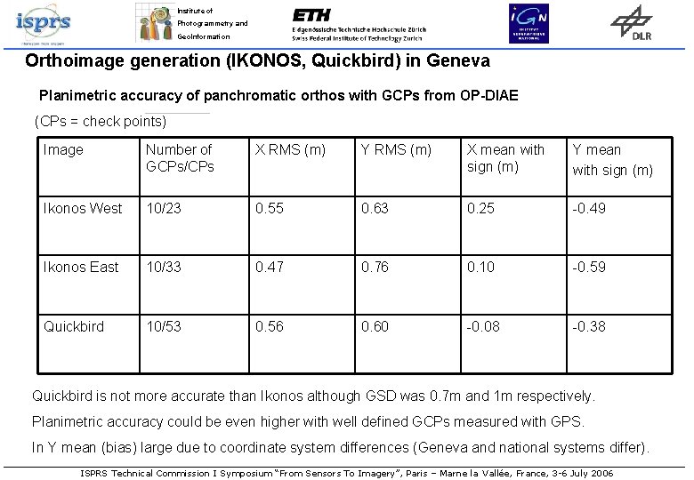
Institute of Photogrammetry and Geo. Information Orthoimage generation (IKONOS, Quickbird) in Geneva Planimetric accuracy of panchromatic orthos with GCPs from OP-DIAE (CPs = check points) Image Number of GCPs/CPs X RMS (m) Y RMS (m) X mean with sign (m) Y mean with sign (m) Ikonos West 10/23 0. 55 0. 63 0. 25 -0. 49 Ikonos East 10/33 0. 47 0. 76 0. 10 -0. 59 Quickbird 10/53 0. 56 0. 60 -0. 08 -0. 38 Quickbird is not more accurate than Ikonos although GSD was 0. 7 m and 1 m respectively. Planimetric accuracy could be even higher with well defined GCPs measured with GPS. In Y mean (bias) large due to coordinate system differences (Geneva and national systems differ). ISPRS Technical Commission I Symposium “From Sensors To Imagery”, Paris – Marne la Vallée, France, 3 -6 July 2006
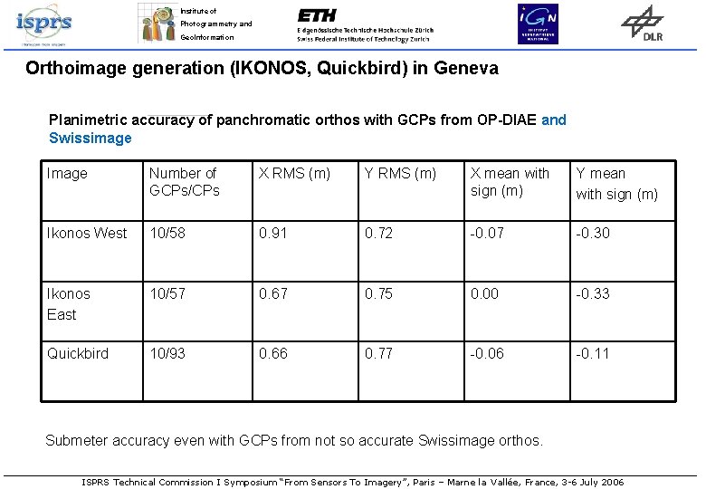
Institute of Photogrammetry and Geo. Information Orthoimage generation (IKONOS, Quickbird) in Geneva Planimetric accuracy of panchromatic orthos with GCPs from OP-DIAE and Swissimage Image Number of GCPs/CPs X RMS (m) Y RMS (m) X mean with sign (m) Y mean with sign (m) Ikonos West 10/58 0. 91 0. 72 -0. 07 -0. 30 Ikonos East 10/57 0. 67 0. 75 0. 00 -0. 33 Quickbird 10/93 0. 66 0. 77 -0. 06 -0. 11 Submeter accuracy even with GCPs from not so accurate Swissimage orthos. ISPRS Technical Commission I Symposium “From Sensors To Imagery”, Paris – Marne la Vallée, France, 3 -6 July 2006
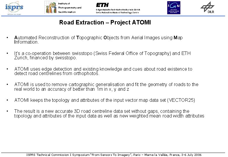
Institute of Photogrammetry and Geo. Information Road Extraction – Project ATOMI • Automated Reconstruction of Topographic Objects from Aerial Images using Map Information. • It’s a co-operation between swisstopo (Swiss Federal Office of Topography) and ETH Zurich, financed by swisstopo. • ATOMI uses edge detection and existing knowledge and cues about road existence to detect road centrelines from orthophotos. • ATOMI is used to remove cartographic generalisation and fit the geometry of roads to the real world to an accuracy of better than 1 m in x, y and z • ATOMI keeps the topology and attributes of the input vector map data set (VECTOR 25) • The result is a new accurate 3 D road centreline data set without gaps, containing the topology and attributes of the input data as well as new weighted mean road width attributes ISPRS Technical Commission I Symposium “From Sensors To Imagery”, Paris – Marne la Vallée, France, 3 -6 July 2006
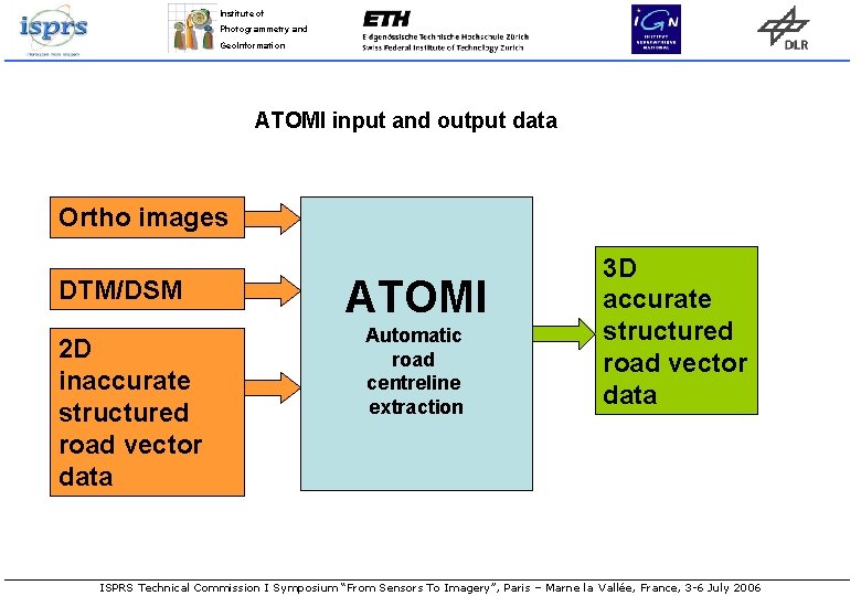
Institute of Photogrammetry and Geo. Information ATOMI input and output data Ortho images DTM/DSM 2 D inaccurate structured road vector data ATOMI Automatic road centreline extraction 3 D accurate structured road vector data ISPRS Technical Commission I Symposium “From Sensors To Imagery”, Paris – Marne la Vallée, France, 3 -6 July 2006
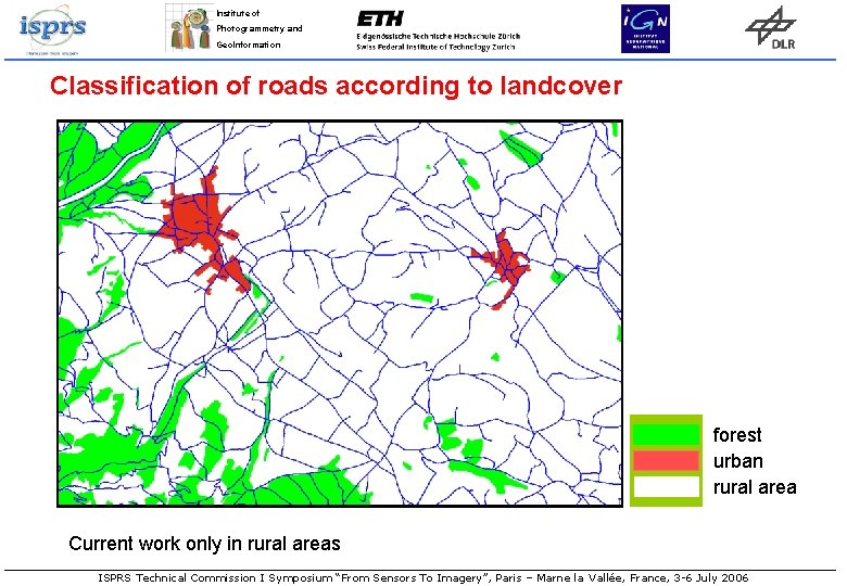
Institute of Photogrammetry and Geo. Information Classification of roads according to landcover forest urban rural area Current work only in rural areas ISPRS Technical Commission I Symposium “From Sensors To Imagery”, Paris – Marne la Vallée, France, 3 -6 July 2006
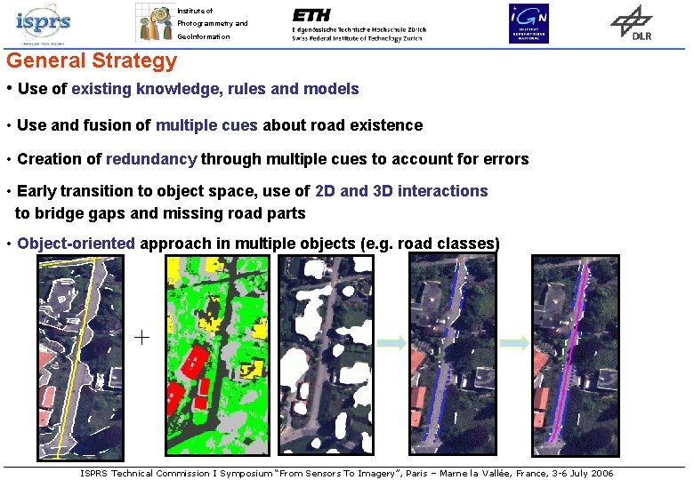
Institute of Photogrammetry and Geo. Information General Strategy • Use of existing knowledge, rules and models • Use and fusion of multiple cues about road existence • Creation of redundancy through multiple cues to account for errors • Early transition to object space, use of 2 D and 3 D interactions to bridge gaps and missing road parts • Object-oriented approach in multiple objects (e. g. road classes) + ISPRS Technical Commission I Symposium “From Sensors To Imagery”, Paris – Marne la Vallée, France, 3 -6 July 2006
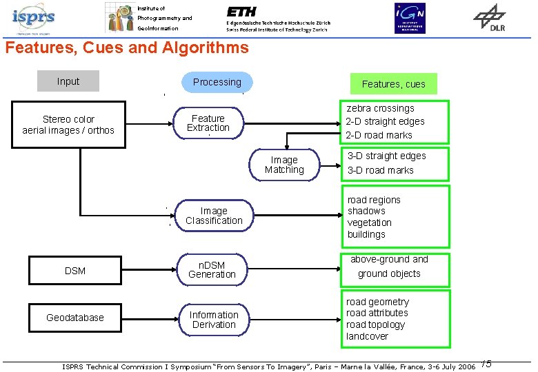
Institute of Photogrammetry and Geo. Information Features, Cues and Algorithms Input Stereo color aerial images / orthos Processing Features, cues zebra crossings 2 -D straight edges 2 -D road marks Feature Extraction Image Matching DSM Geodatabase 3 -D straight edges 3 -D road marks Image Classification road regions shadows vegetation buildings n. DSM Generation above-ground and ground objects Information Derivation road geometry road attributes road topology landcover ISPRS Technical Commission I Symposium “From Sensors To Imagery”, Paris – Marne la Vallée, France, 3 -6 July 2006 15
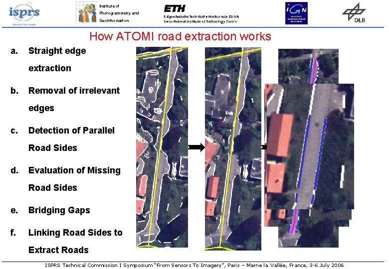
Institute of Photogrammetry and Geo. Information How ATOMI road extraction works a. Straight edge extraction b. Removal of irrelevant edges c. Detection of Parallel Road Sides d. Evaluation of Missing Road Sides e. Bridging Gaps f. Linking Road Sides to Extract Roads ISPRS Technical Commission I Symposium “From Sensors To Imagery”, Paris – Marne la Vallée, France, 3 -6 July 2006
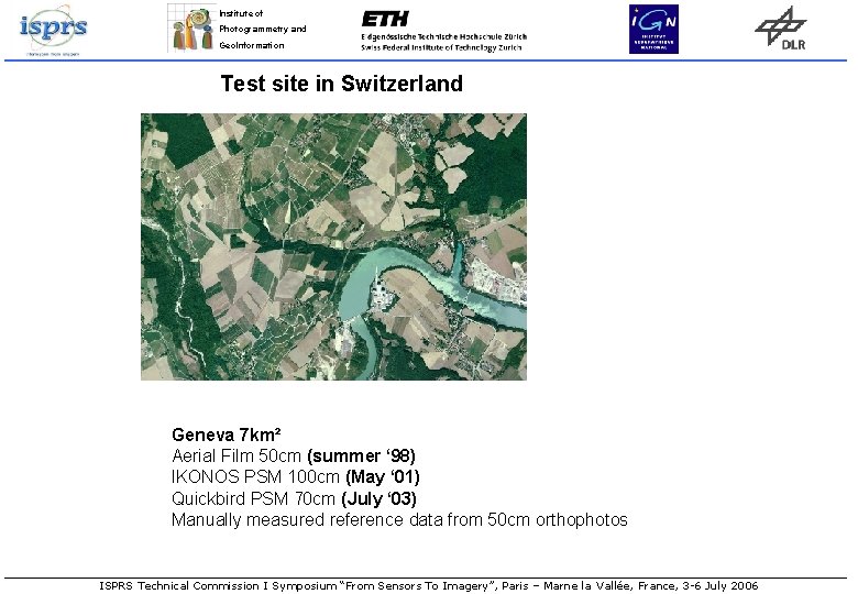
Institute of Photogrammetry and Geo. Information Test site in Switzerland Geneva 7 km² Aerial Film 50 cm (summer ‘ 98) IKONOS PSM 100 cm (May ‘ 01) Quickbird PSM 70 cm (July ‘ 03) Manually measured reference data from 50 cm orthophotos ISPRS Technical Commission I Symposium “From Sensors To Imagery”, Paris – Marne la Vallée, France, 3 -6 July 2006
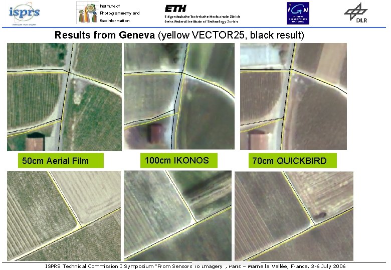
Institute of Photogrammetry and Geo. Information Results from Geneva (yellow VECTOR 25, black result) 50 cm Aerial Film 100 cm IKONOS 70 cm QUICKBIRD ISPRS Technical Commission I Symposium “From Sensors To Imagery”, Paris – Marne la Vallée, France, 3 -6 July 2006
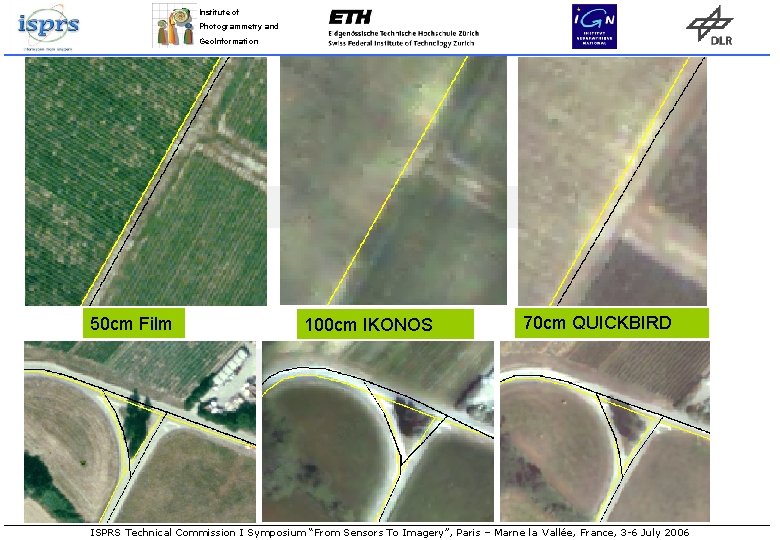
Institute of Photogrammetry and Geo. Information 50 cm Film 100 cm IKONOS 70 cm QUICKBIRD ISPRS Technical Commission I Symposium “From Sensors To Imagery”, Paris – Marne la Vallée, France, 3 -6 July 2006
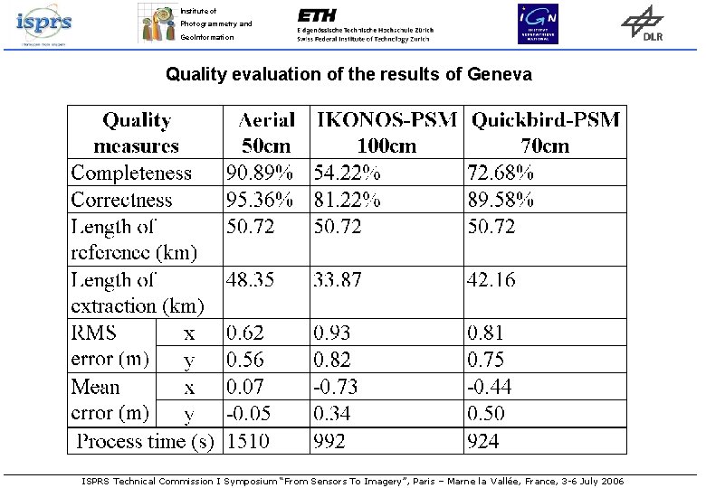
Institute of Photogrammetry and Geo. Information Quality evaluation of the results of Geneva ISPRS Technical Commission I Symposium “From Sensors To Imagery”, Paris – Marne la Vallée, France, 3 -6 July 2006
Institute of Photogrammetry and Geo. Information Results from Geneva • The system achieved good results with the 50 cm aerial film imagery with 90% of rural roads extracted. • The performance (mainly the completeness) of the satellite data was inferior to aerial imagery, especially the 1 m IKONOS imagery • In the satellite data, higher class (wider) roads were usually extracted, while most lower class (narrower) roads were not. This is because of ATOMI’s algorithm requirement of min. 3 pixels road widths was not fulfilled. • The smaller GSD of Quickbird made more roads visible and the road surface and road edges were clearer. But compared to aerial film the completeness was lower. • With smaller GSD, correctness and accuracy do not deteriorate much, but completeness yes. • Other road extraction methods and results with aerial and Ikonos images as part of Euro. SDR working group on road extraction See paper Mayer et al. in coming ISPRS Com. III Symposium, Bonn, September 2006 • ISPRS Technical Commission I Symposium “From Sensors To Imagery”, Paris – Marne la Vallée, France, 3 -6 July 2006
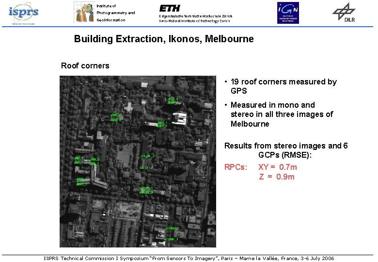
Institute of Photogrammetry and Geo. Information Building Extraction, Ikonos, Melbourne Roof corners • 19 roof corners measured by GPS • Measured in mono and stereo in all three images of Melbourne Results from stereo images and 6 GCPs (RMSE): RPCs: XY = 0. 7 m Z = 0. 9 m ISPRS Technical Commission I Symposium “From Sensors To Imagery”, Paris – Marne la Vallée, France, 3 -6 July 2006
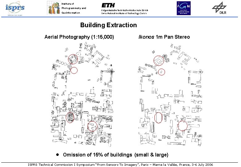
Institute of Photogrammetry and Geo. Information Building Extraction Aerial Photography (1: 15, 000) · Ikonos 1 m Pan Stereo Omission of 15% of buildings (small & large) ISPRS Technical Commission I Symposium “From Sensors To Imagery”, Paris – Marne la Vallée, France, 3 -6 July 2006
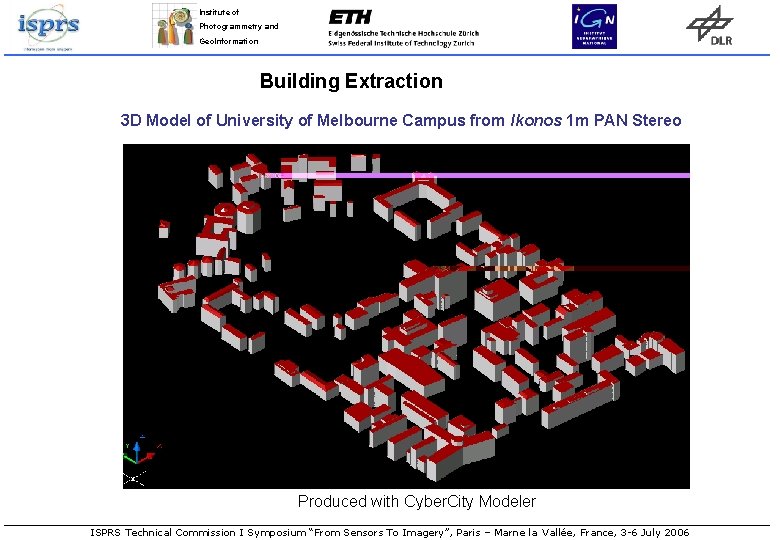
Institute of Photogrammetry and Geo. Information Building Extraction 3 D Model of University of Melbourne Campus from Ikonos 1 m PAN Stereo Produced with Cyber. City Modeler ISPRS Technical Commission I Symposium “From Sensors To Imagery”, Paris – Marne la Vallée, France, 3 -6 July 2006
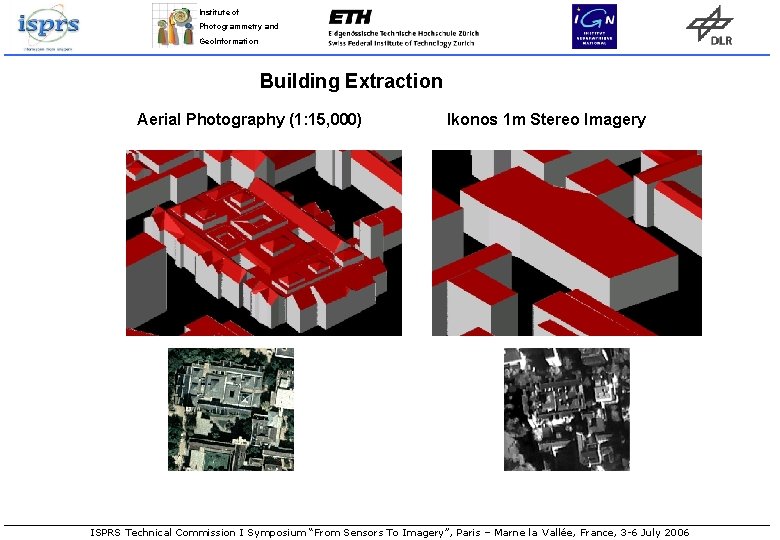
Institute of Photogrammetry and Geo. Information Building Extraction Aerial Photography (1: 15, 000) Ikonos 1 m Stereo Imagery ISPRS Technical Commission I Symposium “From Sensors To Imagery”, Paris – Marne la Vallée, France, 3 -6 July 2006
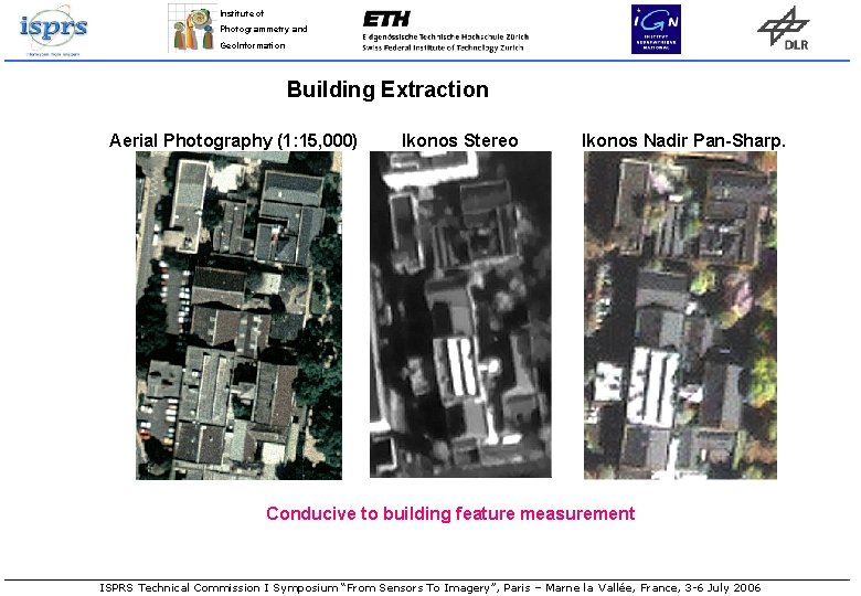
Institute of Photogrammetry and Geo. Information Building Extraction Aerial Photography (1: 15, 000) Ikonos Stereo Ikonos Nadir Pan-Sharp. Conducive to building feature measurement ISPRS Technical Commission I Symposium “From Sensors To Imagery”, Paris – Marne la Vallée, France, 3 -6 July 2006
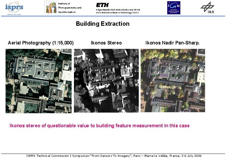
Institute of Photogrammetry and Geo. Information Building Extraction Aerial Photography (1: 15, 000) Ikonos Stereo Ikonos Nadir Pan-Sharp. Ikonos stereo of questionable value to building feature measurement in this case ISPRS Technical Commission I Symposium “From Sensors To Imagery”, Paris – Marne la Vallée, France, 3 -6 July 2006
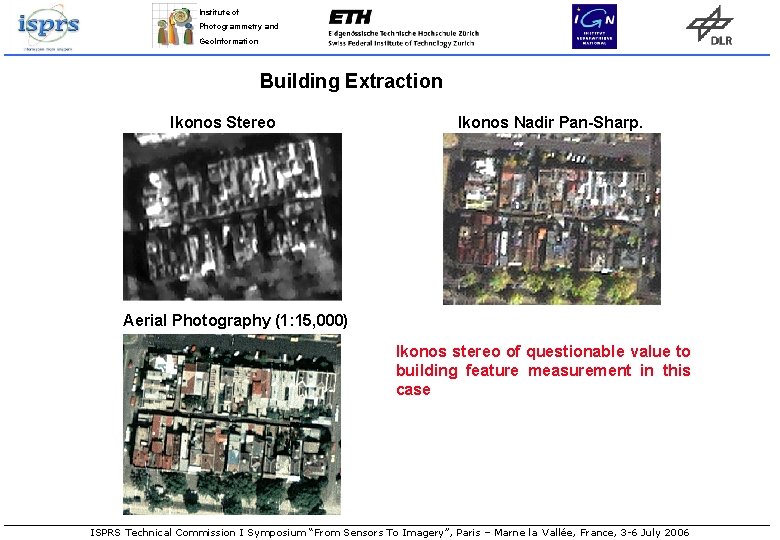
Institute of Photogrammetry and Geo. Information Building Extraction Ikonos Stereo Ikonos Nadir Pan-Sharp. Aerial Photography (1: 15, 000) Ikonos stereo of questionable value to building feature measurement in this case ISPRS Technical Commission I Symposium “From Sensors To Imagery”, Paris – Marne la Vallée, France, 3 -6 July 2006
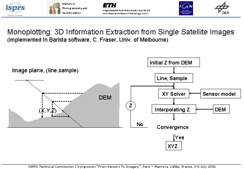
Institute of Photogrammetry and Geo. Information Monoplotting: 3 D Information Extraction from Single Satellite Images (implemented In Barista software, C. Fraser, Univ. of Melbourne) Initial Z from DEM Image plane, (line, sample) Line, Sample XY Solver DEM (X, Y, Z) Z Interpolating Z No Sensor model DEM Convergence Yes XYZ ISPRS Technical Commission I Symposium “From Sensors To Imagery”, Paris – Marne la Vallée, France, 3 -6 July 2006
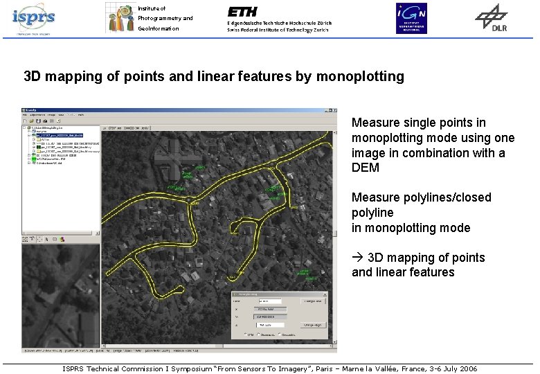
Institute of Photogrammetry and Geo. Information 3 D mapping of points and linear features by monoplotting Measure single points in monoplotting mode using one image in combination with a DEM Measure polylines/closed polyline in monoplotting mode 3 D mapping of points and linear features ISPRS Technical Commission I Symposium “From Sensors To Imagery”, Paris – Marne la Vallée, France, 3 -6 July 2006
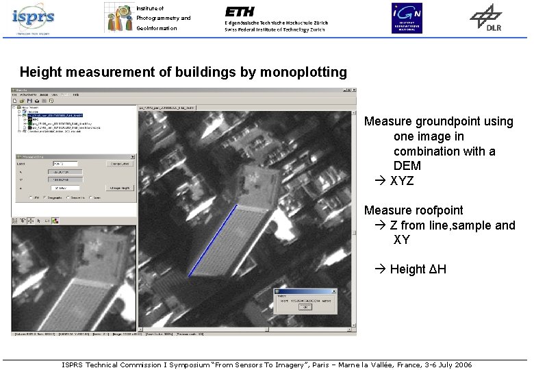
Institute of Photogrammetry and Geo. Information Height measurement of buildings by monoplotting Measure groundpoint using one image in combination with a DEM XYZ Measure roofpoint Z from line, sample and XY Height ΔH ISPRS Technical Commission I Symposium “From Sensors To Imagery”, Paris – Marne la Vallée, France, 3 -6 July 2006
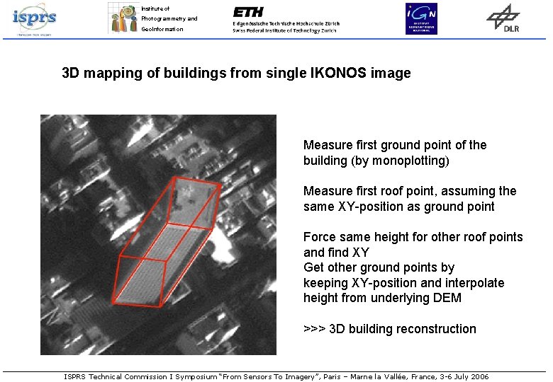
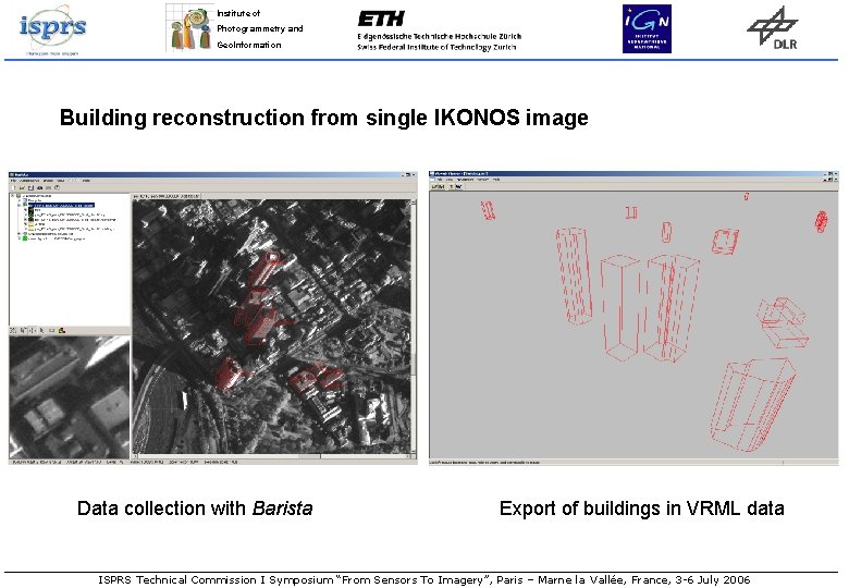
Institute of Photogrammetry and Geo. Information 3 D mapping of buildings from single IKONOS image Measure first ground point of the building (by monoplotting) Measure first roof point, assuming the same XY-position as ground point Force same height for other roof points and find XY Get other ground points by keeping XY-position and interpolate height from underlying DEM >>> 3 D building reconstruction ISPRS Technical Commission I Symposium “From Sensors To Imagery”, Paris – Marne la Vallée, France, 3 -6 July 2006
Institute of Photogrammetry and Geo. Information Building reconstruction from single IKONOS image Data collection with Barista Export of buildings in VRML data ISPRS Technical Commission I Symposium “From Sensors To Imagery”, Paris – Marne la Vallée, France, 3 -6 July 2006
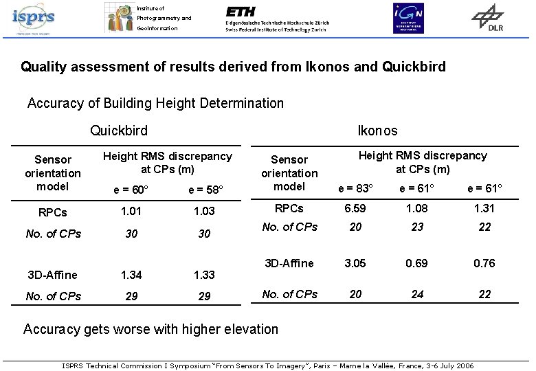
Institute of Photogrammetry and Geo. Information Quality assessment of results derived from IKONOS and Quickbird imagery • GCPs and multi-image data used as reference • Single image point positions and building heights were measured • Bias-corrected RPCs and affine sensor model was used • Measurements were performed in three IKONOS and two Quickbird images • Regular monoplotting mainly depending on DEM quality • Single-image height measurement affected significantly by off-nadir angle ISPRS Technical Commission I Symposium “From Sensors To Imagery”, Paris – Marne la Vallée, France, 3 -6 July 2006
Institute of Photogrammetry and Geo. Information Quality assessment of results derived from Ikonos and Quickbird Accuracy of Building Height Determination Quickbird Ikonos Sensor orientation model Height RMS discrepancy at CPs (m) e = 60° e = 58° Sensor orientation model RPCs 1. 01 1. 03 RPCs 6. 59 1. 08 1. 31 No. of CPs 30 30 No. of CPs 20 23 22 3 D-Affine 3. 05 0. 69 0. 76 No. of CPs 20 24 22 3 D-Affine 1. 34 1. 33 No. of CPs 29 29 e = 83° e = 61° Accuracy gets worse with higher elevation ISPRS Technical Commission I Symposium “From Sensors To Imagery”, Paris – Marne la Vallée, France, 3 -6 July 2006
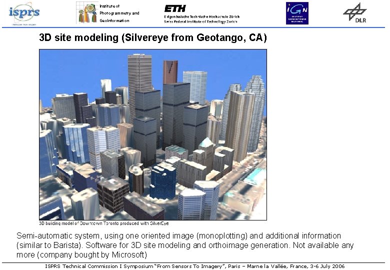
Institute of Photogrammetry and Geo. Information 3 D site modeling (Silvereye from Geotango, CA) Semi-automatic system, using one oriented image (monoplotting) and additional information (similar to Barista). Software for 3 D site modeling and orthoimage generation. Not available any more (company bought by Microsoft) ISPRS Technical Commission I Symposium “From Sensors To Imagery”, Paris – Marne la Vallée, France, 3 -6 July 2006
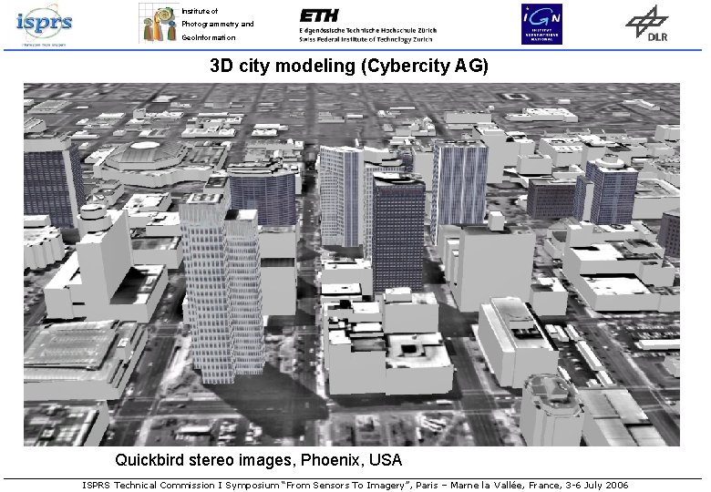
Institute of Photogrammetry and Geo. Information 3 D city modeling (Cybercity AG) Quickbird stereo images, Phoenix, USA ISPRS Technical Commission I Symposium “From Sensors To Imagery”, Paris – Marne la Vallée, France, 3 -6 July 2006
Institute of Photogrammetry and Geo. Information WEB-based 3 D earth visualisation and Location Based Services • Google Keyhole (Quickbird) • Similar devepments by Microsoft (Orbimage) • Geotango‘s (CA) Globeview (company bought by Microsoft) • Use of satellite images, espec. HR • DSM from usually unknown sources • 3 D building models • Driving directions • Location of various services ISPRS Technical Commission I Symposium “From Sensors To Imagery”, Paris – Marne la Vallée, France, 3 -6 July 2006