Geoinformatics Zulfiqar Ali E Mail zulfiqar alics uol


 grade –")
")
 (Our data")
: A satellite system that projects information to GPS receivers on")
: An agricultural producer may use a handheld GPS receiver to")


- Slides: 28
Geoinformatics Zulfiqar Ali E Mail: zulfiqar. ali@cs. uol. edu. pk
Global Positioning Systems � GPS components. � � Difference between GPS and GIS � Examples of GPS data collection � Examples of GIS software output � Potential of GPS and GIS technologies in a plant bio security management context
� What is GPS? What is GIS? � How do GPS and GIS work? � How will they help us? ? Find This !
� Consider for a moment that when you are riding in a commercial airliner, the pilot and crew are navigating to your destination with the aid of the Global Positioning System (GPS). � Further, many luxury cars now come with builtin navigation systems that include GPS receivers with digital maps, and you can purchase handheld GPS navigation units that will give your position on the Earth (latitude, longitude, and altitude) to an accuracy of 5 to 10 meters that weigh only a few ounces and cost around $100.
� GPS stands for Global Positioning System � GPS is a satellite navigation system designed to provide accurate position, velocity, and time information almost anywhere in the world � The present system is known as NAVSTAR - NAVigation Satellite Timing And Ranging � The GPS program operated and controlled by the US Department of Defense
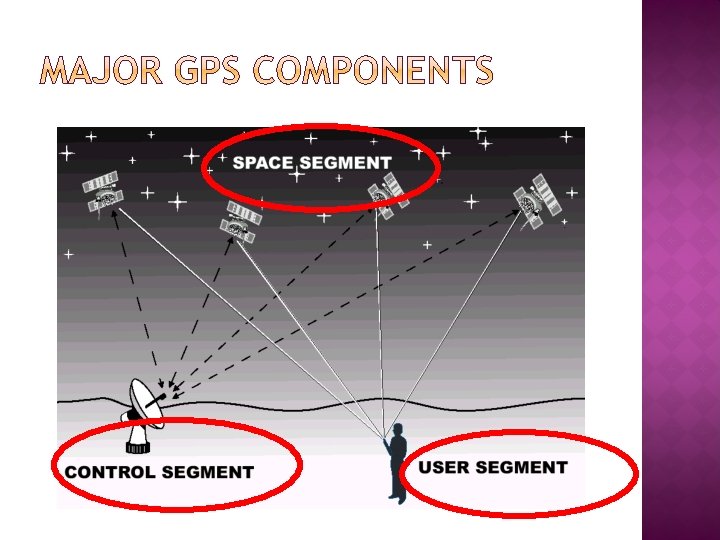
� The current GPS configuration consists of a network of 24 satellites in high orbits around the Earth. � Each satellite in the GPS constellation orbits at an altitude of about 20, 000 km from the ground. � Has an orbital speed of about 14, 000 km/hour (the orbital period is roughly 12 hours. � GPS satellites are not in geosynchronous or geostationary orbits). � The satellite orbits are distributed so that at least 4 satellites are always visible from any point on the Earth at any given instant (with up to 12 visible at one time)
� Each satellite broadcasts its orbital position as a modulated signal � Receiver determines the difference between the time signal from the satellite and its own internal clock � The distance from the satellite can be calculated using the speed of light (300, 000 km/second) � Position and distance from 3 or 4 satellites allows triangulation of receiver’s position
� � � A collection of 24 orbiting satellites with 3 -4 spares Orbit at a distance of 11, 000 miles (about 20, 000 km from the ground) Each satellite contains several very precise atomic clocks (Because an observer on the ground sees the satellites in motion relative to them, Special Relativity predicts that we should see their clocks ticking more slowly. Special Relativity predicts that on-board atomic clocks on the satellites should fall behind clocks on the ground by about 7 microseconds per day because of the slower ticking rate due to the time dilation effect of their relative motion. Orbit roughly every 12 hours, but they are not geosynchronous (A geosynchronous orbit sometimes abbreviated GSO, is an orbit around the Earth with an orbital period of one sidereal day (approximately 23 hours 56 minutes. .
� There are five Control Stations around the world � Stations monitor satellites as they pass overhead by measuring the distance from the Control Station to the satellites � Master Control Station determines satellite conditions (orbit, clock, health status) and calibrates the satellite’s clock
� Accuracy is dependent on the kind of receiver � Navigation (Recreation) grade – least accurate � Mapping grade – accurate � Survey grade – most accurate � Costs range from $100 to $30, 000
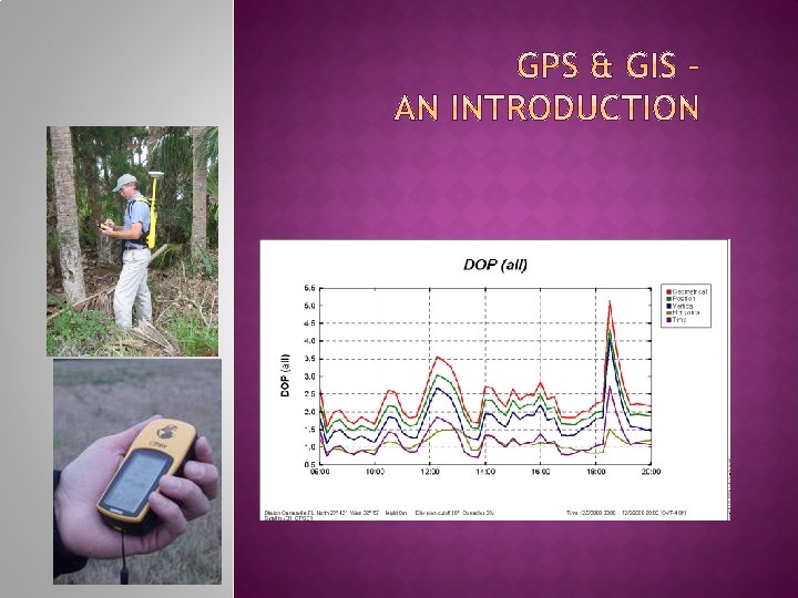
DOP = Dilution of Precision (This means that the signal degrades)
DOP projection for 23 January 2009 collection day) (Our data
Global Positioning System (GPS): A satellite system that projects information to GPS receivers on the ground, enabling users to determine latitude and longitude coordinates. Global Information System (GIS): Software program that enable users to store and manipulate large amounts of data from GPS and other sources.
Global Positioning System (GPS): An agricultural producer may use a handheld GPS receiver to determine the latitude and longitude coordinates of a water source next to a field. Global Information System (GIS): Following a chemical spill, maps obtained from a GIS system can reveal environmentally-sensitive areas that should be protected during response and recovery phases. Source: Purdue University
� Depending on the make and model of the unit, the number of satellites available, and the quality of (unobstructed) signals, GPS receivers can collect information such as § Latitude and longitude coordinates (time-in-place or point location) § “Real Time” position (calculated while farm equipment is moving) § Elevation (if 4 or more satellites are used)
A GIS database creates “layers” with many pieces of information visualized for the same area. Yield data – collected using GPS Topsoil Depth - collected using GPS Aerial photo of the are Source: University of Missouri
This layered map shows a potential disaster impact area outlined in white by GIS software. Source: Purdue University
Did you know… GIS information and maps have a variety of uses in the agricultural sector, including the potential to assist Vigilance response, recovery, and improvement efforts in plant bio security (Bio security is a set of preventive measures designed to reduce the risk of transmission of infectious diseases, quarantined pests) management.
Applications in Plant Bio security Management Case example: Responding to Plant Bio security Problem Source: Purdue University Situation: Confirmed case of a plant disease in a small test plot.
CASE EXAMPLE -- CONTINUED Facts: � � � Disease spores (A spore is a reproductive cell produced by certain fungi, plants (moss, ferns), and some bacteria. Certain bacteria make spores as a way to defend themselves. ) may be spread by the wind. Combine used in this field was not disinfected. Two neighbors borrowed the combine. Combine traded and shipped from dealer by rail. Estimated range of movement of disease is one mile. Response Task: ü Notify all farms within one mile of the infected field, neighbors’ fields, highway, and railroad.
First, information such as wind direction, speed, and duration are entered in to an existing GIS database for the area. Source: Purdue University
Next, “queries” are run to retrieve information from the GIS data base, such as a map of the potential impact area. Green dots represent farms in the potential impact area. This particular database allows one to “zoom in” on the green dots to obtain aerial photos. Source: Purdue University
Other queries can be run, to obtain maps of highways and railways. . . Source: Purdue University
. . . and to identify affected farms within a designated quarantine area. Source: Purdue University
If the established GIS database is extensive, detailed information may be obtained, such as producers’ names, phone numbers, and exact locations, facilitating rapid response efforts. Source: Purdue University
� GPS is a system of satellites. Receivers identify pointspecific and “real-time” locations � GIS software programs can merge data from GPS and numerous other sources � Maps and tables from GIS programs can facilitate responders’ fast and accurate response to a plant bio security problem � GPS and GIS technologies can assist producers’ improvement and preparedness efforts by identifying potential impact areas and areas vulnerable to intentional and unintentional bio security problems.