GEOMATICS AND GEOINFORMATICS IN MODERN INFORMATION SOCIETY PROJECTION
- Slides: 12
GEOMATICS AND GEOINFORMATICS IN MODERN INFORMATION SOCIETY PROJECTION OF NEW TRENDS INTO THEIR CURRICULA AT THE UNIVERSITY OF WEST BOHEMIA IN PILSEN Jiří ŠÍMA, Czech Republic University of West Bohemia in Pilsen Faculty of Applied Sciences Department of Geomatics
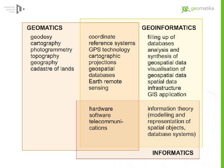
GEOMATICS A discipline concerned with the collection, distribution, storage, analysis, processing, presentation of geographic data or geographic information • • • national spatial reference system state topographic map series aerial photography surveys on state boundaries cadastral surveys national bases of geographic data
GEOINFORMATICS A discipline concerned with theory of geospatial data modelling, their storage, management and processing as well as with development of geographic information systems and necessary information- and communication technology • development and management of geospatial databases • analysis and modelling of geospatial data • development and integration of computer tools and software for the first two tasks
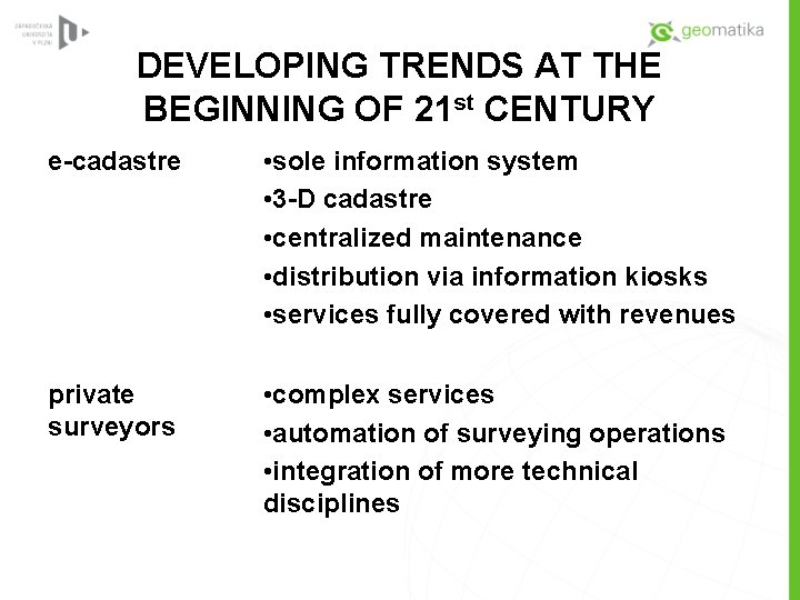
DEVELOPING TRENDS AT THE BEGINNING OF 21 st CENTURY e-cadastre • sole information system • 3 -D cadastre • centralized maintenance • distribution via information kiosks • services fully covered with revenues private surveyors • complex services • automation of surveying operations • integration of more technical disciplines
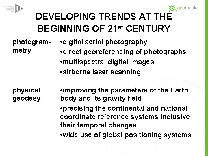
DEVELOPING TRENDS AT THE BEGINNING OF 21 st CENTURY photogrammetry • digital aerial photography • direct georeferencing of photographs • multispectral digital images • airborne laser scanning physical geodesy • improving the parameters of the Earth body and its gravity field • precising the continental and national coordinate reference systems inclusive their temporal changes • wide use of global positioning systems
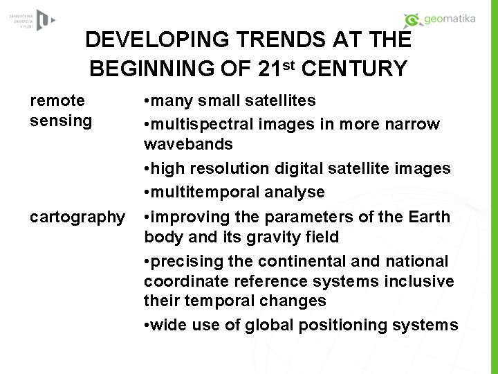
DEVELOPING TRENDS AT THE BEGINNING OF 21 st CENTURY remote sensing cartography • many small satellites • multispectral images in more narrow wavebands • high resolution digital satellite images • multitemporal analyse • improving the parameters of the Earth body and its gravity field • precising the continental and national coordinate reference systems inclusive their temporal changes • wide use of global positioning systems
UNIVERSITY OF WEST BOHEMIA IN PILSEN FACULTY OF APPLIED SCIENCES CHAIR OF MATHEMATICS DEPARTMENT OF GEOMATICS • Bachelor study programme Geomatics (since 1995) • Master study programme Geomatics (since 1995) • Ph. D. study programme Geomatics (since 2006) • Bachelor study programme Geoinformatics (in accreditation)
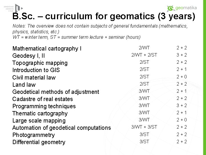
B. Sc. – curriculum for geomatics (3 years) Notes: The overview does not contain subjects of general fundamentals (mathematics, physics, statistics, etc. ) WT = winter term, ST = summer term lecture + seminar (hours) Mathematical cartography I Geodesy I, II Topographic mapping Introduction to GIS Civil material law Land law Geodetical methods of adjustment Cadastre of real estates Programming techniques Thematic cartography Large scale mapping Automation of geodetical computations Photogrammetry Differential geometry 2/WT 2+2 2/WT + 2/ST 3+2 2/ST 2+1 2/ST 2+0 2/ST 2+2 3/WT 2+1 3/WT 2+2 3/WT 3+2 3/WT 2+1 3/WT 2+0 3/WT + 3/ST 2+2
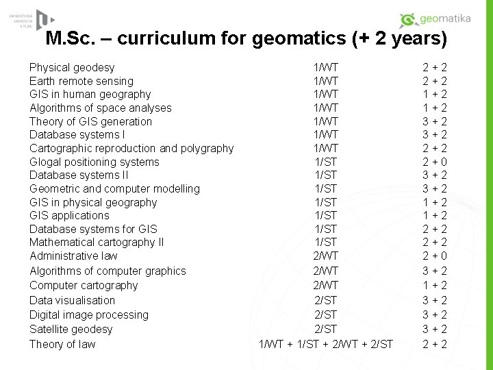
M. Sc. – curriculum for geomatics (+ 2 years) Physical geodesy Earth remote sensing GIS in human geography Algorithms of space analyses Theory of GIS generation Database systems I Cartographic reproduction and polygraphy Glogal positioning systems Database systems II Geometric and computer modelling GIS in physical geography GIS applications Database systems for GIS Mathematical cartography II Administrative law Algorithms of computer graphics Computer cartography Data visualisation Digital image processing Satellite geodesy Theory of law 1/WT 1/WT 1/ST 1/ST 2/WT 2/ST 1/WT + 1/ST + 2/WT + 2/ST 2+2 1+2 3+2 2+2 2+0 3+2 1+2 3+2 3+2 2+2
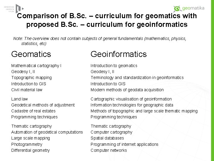
Comparison of B. Sc. – curriculum for geomatics with proposed B. Sc. – curriculum for geoinformatics Note: The overview does not contain subjects of general fundamentals (mathematics, physics, statistics, etc) Geomatics Geoinformatics Mathematical cartography I Geodesy I, II Topographic mapping Introduction to GIS Civil material law Introduction to geomatics Geodesy I, II Terminology and standardization in geoinformatics Introduction to GIS Modern methods of geodata acquisition Land law Geodetical methods of adjustment Cadastre of real estates Programming techniques Cartographic visualisation of geoinformation Information technologies for geographic data Methods of topographic and large scale thematic mapping Programming techniques Thematic cartography Automation of geodetical computations Large scale mapping Photogrammetry Differential geometry Thematic cartography Computer cartography Spatial databases Programming of internet applications Computer networks
Thank you for your attention!