Geoinformatics Muhammad Nadeem Akhtar E Mail nadeem akhterce


 Add the raster dataset")


- Slides: 12
Geo-informatics Muhammad Nadeem Akhtar E Mail: nadeem. akhter@ce. uol. edu. pk URL: https: //sites. google. com/site/ceuolgis/home/gislectures
� Geo-referencing. � Geo-rectification. � Lab # 9 of Geo-referencing & Georectification.
� When a raster, such as an image or scanned map, does not have any spatial information, or when its spatial information is inaccurate, geo-referencing assigns or modifies the real-world coordinates. � One way to geo-reference a raster is to establish Links between specific locations on the image, or target layer, to corresponding locations in a control layer that has the coordinate system information and the accuracy that you want the raster to inherit. � The software then adjusts the raster's display so that it aligns with the control layer—essentially aligning the unknown with the known.
The general steps for geo-referencing a raster dataset are: 1) Add the raster dataset that you want to align with your projected data in Arc Map. 2) Add control points that link known raster dataset positions to known positions in map coordinates. 3) Save the geo-referencing information when you are satisfied with the alignment (also referred to as registration). 4) Optionally, permanently transform the raster dataset.
� � Geo-referenced data is only as accurate as the data to which it was aligned. In the example, on the left, notice the difference between point BM 6249 in the raster and the corresponding point (the yellow point) in the control layer. In the center image, the blue line represents a link that was manually added between the two points. On the right, the raster's display has been adjusted so that it aligns as closely as possible with the control layer—the points that were linked now match.
In this example, links are established between specific locations in a raster to corresponding locations in a control layer. Then, the software adjusts the raster's display so that it aligns with the control layer.
� When you perform geo-referencing by creating links, only the raster's display is adjusted, not the raster data itself. Because the process does not create any new data, it is quite fast. � Note: The geo-referencing processes (for images or even Auto. CAD or Micro station files) are done through Arc Map's Geo-referencing toolbar.
� � If your analysis is visual and it only requires translation, rotation, and scaling, it may be enough to simply georeference your raster, but if you plan to perform analysis with it or want to use it with another software package that does not recognize the external geo-referencing information created by Arc Map, you should geo-rectify it. Geo-referencing allows you to save the coordinate information you created when you geo-referenced an image. You can choose to store the new coordinate information one of two ways: as external files that Arc GIS can reference whenever you display the data (georeferencing), or as a new output dataset that permanently transforms your raster dataset into the new coordinate space (geo-rectifying). Geo-rectifying saves the information as both a new dataset and an external file.
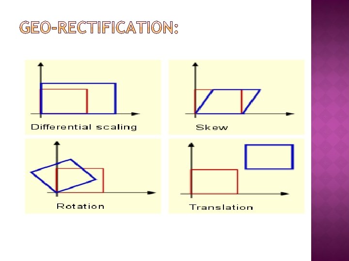
When you geo-rectify a raster, you will need to specify a transformation order. This means that you must choose the equation that Arc GIS will use to geo -rectify, or transform, the input raster. � Unless you have a good understanding of transformation orders, you will probably want to accept the default of the first order polynomial transformation (affine), which should sufficient for most cases. � During the transformation process, Arc GIS uses the links that were established during geo-referencing to scale, skew, stretch, rotate, or warp the input raster and create a new raster. � This process involves recalculating the value of each cell in the input raster to create the new data, so it can take some time. �
� Lab-9 Geo-reference and geo-rectify an image:
Thanks!