Direct Assimilation of SatelliteDerived AMVs into HWRF First
- Slides: 22

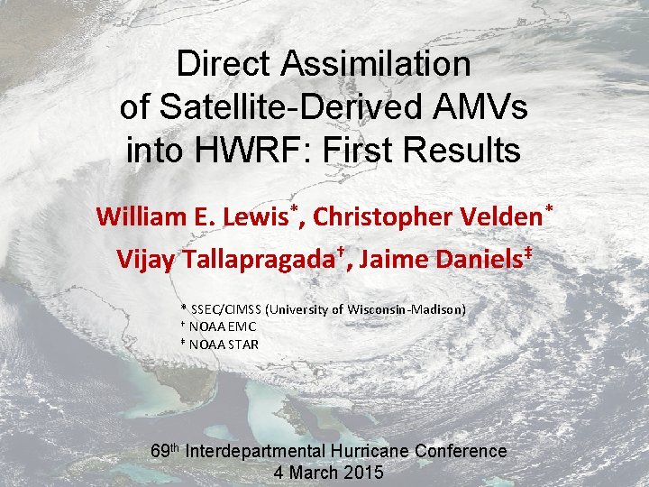
Direct Assimilation of Satellite-Derived AMVs into HWRF: First Results William E. Lewis*, Christopher Velden* Vijay Tallapragada†, Jaime Daniels‡ * SSEC/CIMSS (University of Wisconsin-Madison) † NOAA EMC ‡ NOAA STAR 69 th Interdepartmental Hurricane Conference 4 March 2015

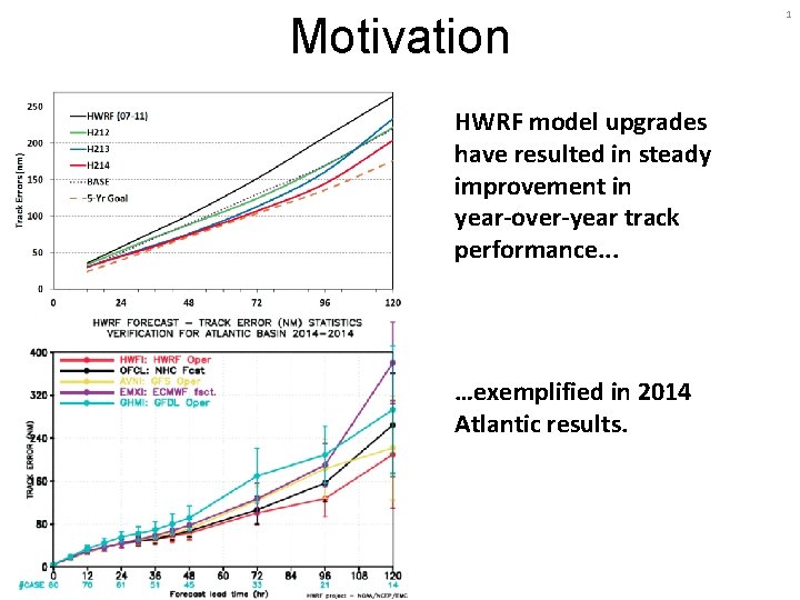
Motivation HWRF model upgrades have resulted in steady improvement in year-over-year track performance. . . …exemplified in 2014 Atlantic results. 1

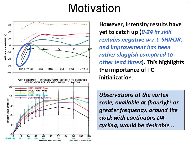
Motivation However, intensity results have yet to catch up (0 -24 hr skill remains negative w. r. t. SHIFOR, and improvement has been rather sluggish compared to other lead times). This highlights the importance of TC initialization. Observations at the vortex scale, available at (hourly)-1 or greater frequency, around the clock with continuous DA cycling, would be desirable. . . 2

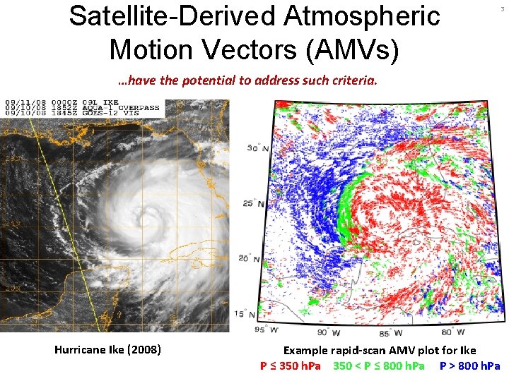
Satellite-Derived Atmospheric Motion Vectors (AMVs) 3 …have the potential to address such criteria. Hurricane Ike (2008) Example rapid-scan AMV plot for Ike P ≤ 350 h. Pa 350 < P ≤ 800 h. Pa P > 800 h. Pa

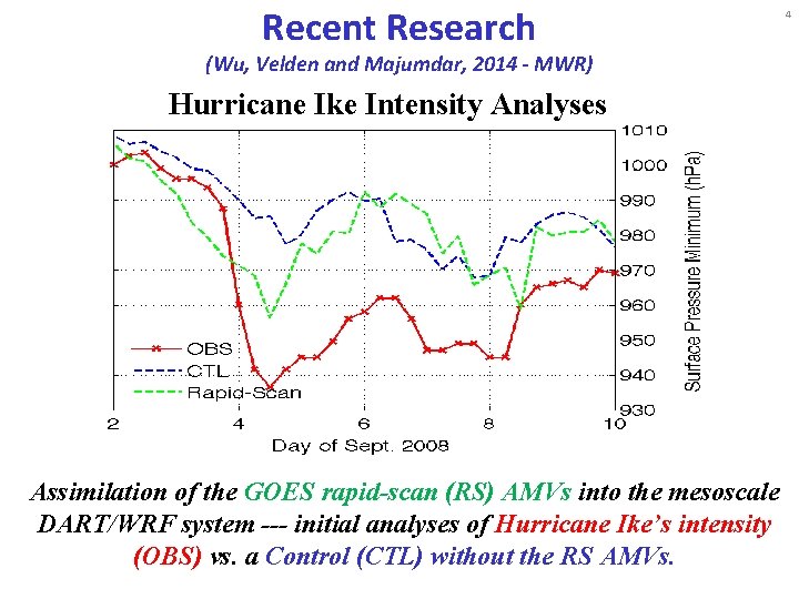
Recent Research (Wu, Velden and Majumdar, 2014 - MWR) Hurricane Ike Intensity Analyses Assimilation of the GOES rapid-scan (RS) AMVs into the mesoscale DART/WRF system --- initial analyses of Hurricane Ike’s intensity (OBS) vs. a Control (CTL) without the RS AMVs. 4

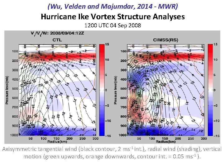
(Wu, Velden and Majumdar, 2014 - MWR) Hurricane Ike Vortex Structure Analyses 1200 UTC 04 Sep 2008 Axisymmetric tangential wind (black contour, 2 ms-1 int. ), radial wind (shading), vertical motion (green upwards, orange downwards, contour int. = 0. 05 ms-1 ).

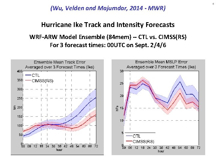
(Wu, Velden and Majumdar, 2014 - MWR) Hurricane Ike Track and Intensity Forecasts WRF-ARW Model Ensemble (84 mem) -- CTL vs. CIMSS(RS) For 3 forecast times: 00 UTC on Sept. 2/4/6 6

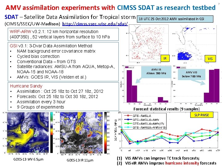
AMV assimilation experiments with CIMSS SDAT as research testbed SDAT – Satellite Data Assimilation for Tropical storm (CIMSS/SSEC/UW-Madison) http: //cimss. ssec. wisc. edu/sdat/ 18 UTC 25 Oct 2012 AMV assimilated in GSI WRF-ARW v 3. 2. 1: 12 km horizontal resolution (400*350) , 52 vertical layers from surface to 10 h. Pa GSI v 3. 1: 3 -Dvar Data Assimilation Method • NAM background error covariance matrix • Cycled bias correction • Conventional Data – from GTS • Satellite radiances: AMSU-A from AQUA, Metop-A, NOAA-15 and NOAA-18 • AMVs: GOES IR, VIS (Velden et al. ) Hurricane Sandy • Assimilation : Oct 25 18 z to Oct 27 18 z, 2012 • Forecasts: Oct 25 18 z to Oct 30 18 z, 2012 • Assimilation every 3 hour • 9 Groups of experiments IR AMV IR Above 300 h. Pa VIS AMV VIS below 700 h. Pa Forecast statistical results (9 samples) SLP RMSE GOES-13 WV 6. 5μm GOES-13 IR 11μm (1) VIS AMVs can improve TC track forecasts; (2) VIS+IR AMVs improve hurricane intensity forecasts 7

AMV Datasets for Sandy • For this study, all AMVs derived from special GOES-14 Super. Rapid-Scan Operations (SRSO)—continuous limited-area 1 -min. imagery during Sandy • Two AMV algorithms tested: 1) Heritage—currently operational at NESDIS (AMV 1) 2) Experimental—being developed for GOES-R (AMV 2) • Both algorithms process AMVs from triplets of VIS (3 -min. imagery) and LWIR/SWIR (5 -min. imagery) • All AMVs are objectively QC’d, and output with Quality Indicator and Expected Error tags, which are used to filter inputs to the DA (thresholds based on previous research) 8

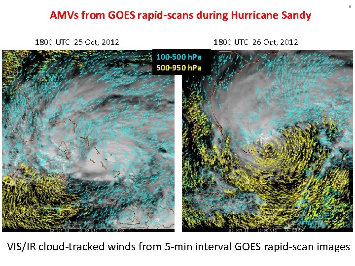
AMVs from GOES rapid-scans during Hurricane Sandy 1800 UTC 25 Oct, 2012 9 1800 UTC 26 Oct, 2012 100 -500 h. Pa 500 -950 h. Pa VIS/IR cloud-tracked winds from 5 -min interval GOES rapid-scan images

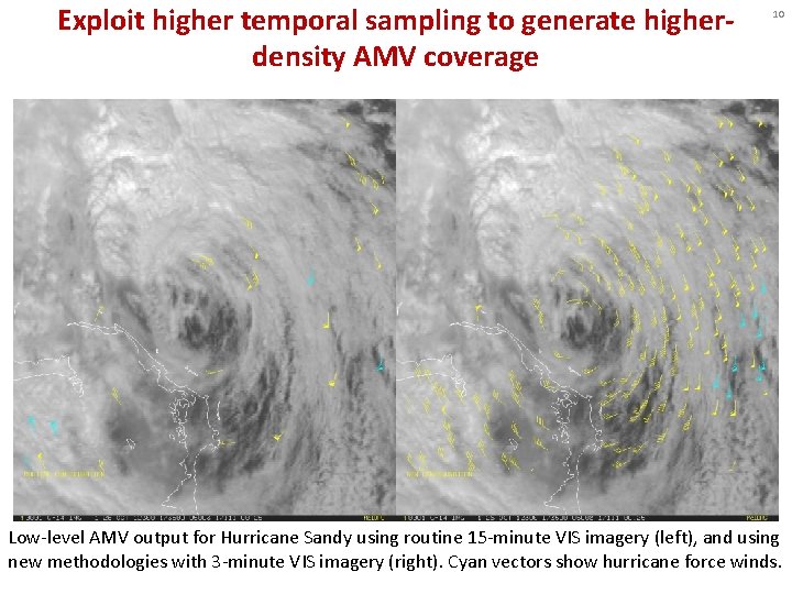
Exploit higher temporal sampling to generate higherdensity AMV coverage 10 Low-level AMV output for Hurricane Sandy using routine 15 -minute VIS imagery (left), and using new methodologies with 3 -minute VIS imagery (right). Cyan vectors show hurricane force winds.

11 HWRF Experiments -- Methodology • HWRF (developmental branch, current as of Nov 2014) and NCEP/EMC GSI data assimilation (October 2014) • Run on ‘Jet’ computer (HFIP-supported resources) • Initial case for study: Hurricane Sandy (2012) • Control: 6 -hr cycling DA from first TCVITALS message, assimilating RAOBs only (per Vijay’s suggestion) • Impact Experiments: as in Control, but additionally assimilate GOES rapid-scan AMVs with default GSI data thinning and QC procedures disabled. AMV datasets within +/- 3 -hr of each analysis time were used. • All obs errors as in errtable from HWRF branch, except reduced 30% at all levels for AMVs (per suggestion of previous research).

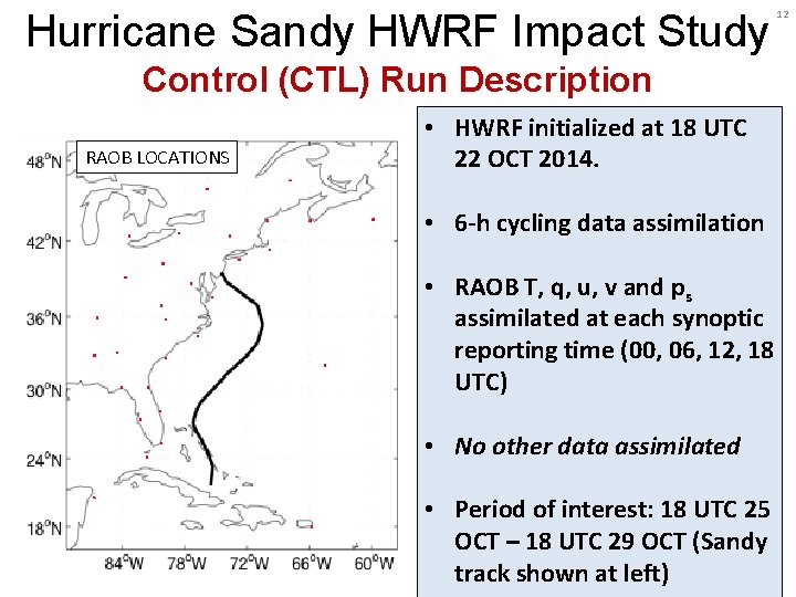
Hurricane Sandy HWRF Impact Study Control (CTL) Run Description RAOB LOCATIONS • HWRF initialized at 18 UTC 22 OCT 2014. • 6 -h cycling data assimilation • RAOB T, q, u, v and ps assimilated at each synoptic reporting time (00, 06, 12, 18 UTC) • No other data assimilated • Period of interest: 18 UTC 25 OCT – 18 UTC 29 OCT (Sandy track shown at left) 12

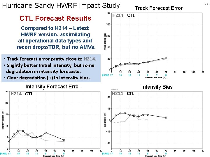
Hurricane Sandy HWRF Impact Study CTL Forecast Results Track Forecast Error H 214 CTL Compared to H 214 – Latest HWRF version, assimilating all operational data types and recon drops/TDR, but no AMVs. • Track forecast error pretty close to H 214. • Slightly better Initial intensity, but some degradation in intensity forecasts. • Clear degradation (+) in intensity bias. Intensity Forecast Error H 214 CTL Intensity Bias H 214 CTL 13

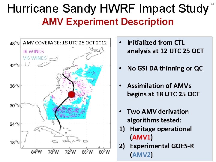
Hurricane Sandy HWRF Impact Study AMV Experiment Description AMV COVERAGE: 18 UTC 28 OCT 2012 IR WINDS VIS WINDS • Initialized from CTL analysis at 12 UTC 25 OCT • No GSI DA thinning or QC • Assimilation of AMVs begins at 18 UTC 25 OCT • Two AMV derivation algorithms tested: 1) Heritage operational (AMV 1) 2) Experimental GOES-R (AMV 2) 14

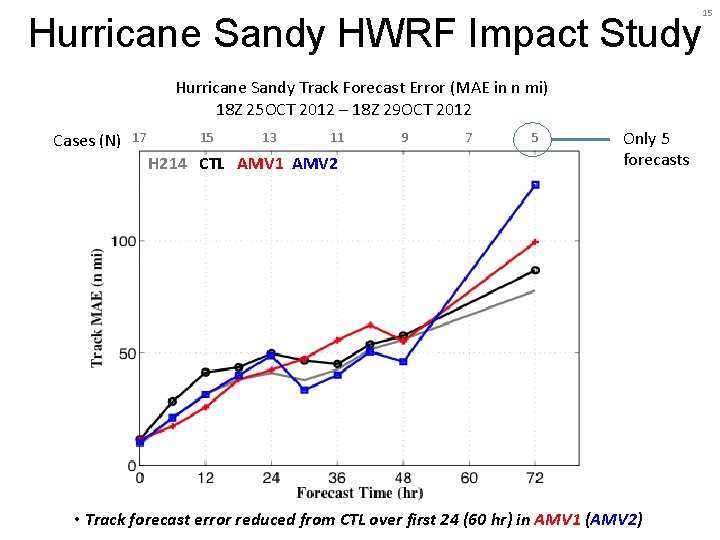
Hurricane Sandy HWRF Impact Study Hurricane Sandy Track Forecast Error (MAE in n mi) 18 Z 25 OCT 2012 – 18 Z 29 OCT 2012 Cases (N) 17 15 13 11 H 214 CTL AMV 1 AMV 2 9 7 5 Only 5 forecasts • Track forecast error reduced from CTL over first 24 (60 hr) in AMV 1 (AMV 2) 15

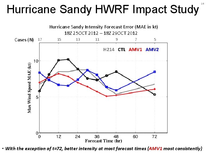
Hurricane Sandy HWRF Impact Study 16 Hurricane Sandy Intensity Forecast Error (MAE in kt) 18 Z 25 OCT 2012 – 18 Z 29 OCT 2012 Cases (N) 17 15 13 11 9 7 5 H 214 CTL AMV 1 AMV 2 • With the exception of t=72, better intensity at most forecast times (AMV 1 most consistently)

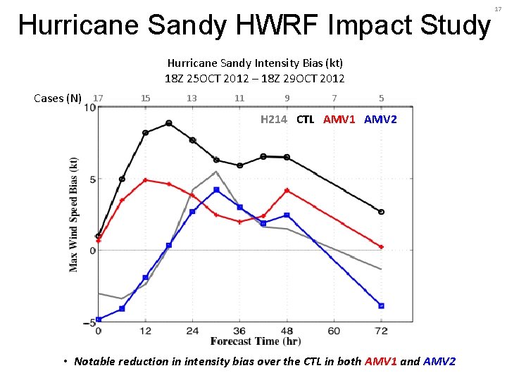
Hurricane Sandy HWRF Impact Study Hurricane Sandy Intensity Bias (kt) 18 Z 25 OCT 2012 – 18 Z 29 OCT 2012 Cases (N) 17 15 13 11 9 7 5 H 214 CTL AMV 1 AMV 2 • Notable reduction in intensity bias over the CTL in both AMV 1 and AMV 2 17

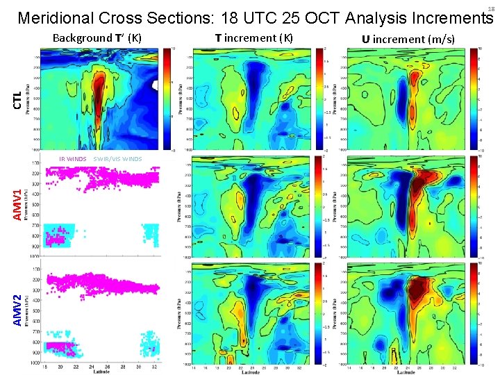
18 Meridional Cross Sections: 18 UTC 25 OCT Analysis Increments CTL Background T’ (K) AMV 2 AMV 1 IR WINDS SWIR/VIS WINDS T increment (K) U increment (m/s)

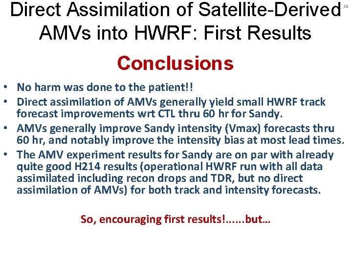
Direct Assimilation of Satellite-Derived AMVs into HWRF: First Results 19 Conclusions • No harm was done to the patient!! • Direct assimilation of AMVs generally yield small HWRF track forecast improvements wrt CTL thru 60 hr for Sandy. • AMVs generally improve Sandy intensity (Vmax) forecasts thru 60 hr, and notably improve the intensity bias at most lead times. • The AMV experiment results for Sandy are on par with already quite good H 214 results (operational HWRF run with all data assimilated including recon drops and TDR, but no direct assimilation of AMVs) for both track and intensity forecasts. So, encouraging first results!. . . but…

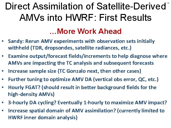
Direct Assimilation of Satellite-Derived AMVs into HWRF: First Results 20 …More Work Ahead • Sandy: Rerun AMV experiments with observation sets initially withheld (TDR, dropsondes, satellite radiances, etc. ) • Examine output/forecast fields/increments to help diagnose where AMVs are impacting the TC analysis and subsequent forecasts • Increase sample size (TC Gonzalo next, then other cases) • Further tuning to optimize AMV DA (vertical obs error, QC, etc. ) • Hourly FGAT? (should result in better background fields for the high-density AMVs) • 3 -hourly DA cycling? Eventually 1 -hourly to maximize AMV impact? • Increase spatial domain of AMV assimilation? (currently limited to HWRF inner domain analysis)

Direct Assimilation of Satellite-Derived AMVs into HWRF: First Results William E. Lewis*, Christopher Velden* Vijay Tallapragada†, Jaime Daniels‡ * SSEC/CIMSS (University of Wisconsin-Madison) † NOAA EMC ‡ NOAA STAR Questions? Research sponsors: HFIP and GOES-R Risk Reduction