Impacts of highresolution Himawari8 AMVs on TC forecast

- Slides: 54

Impacts of high-resolution Himawari-8 AMVs on TC forecast in HWRF Masahiro Sawada (Dr) Visiting Scientist from Meteorological Research Institute, JMA Acknowledgements: HWRF group at EMC & DTC

contents • Background & Objectives of this study • What is high-resolution Himawari-8 AMV? • Model & Experimental design • Outline of target cases • Results • Detailed analysis • Summary 2

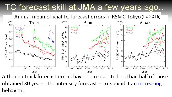
TC forecast skill at JMA a few years ago… Annual mean official TC forecast errors in RSMC Tokyo (Ito 2016) Track Pmin Vmax Although track forecast errors have decreased to less than half of those obtained 30 years…the intensity forecast errors exhibit an increasing behavior.

Introduction & background • Accurately estimating the tropical cyclone (TC) intensity and structure is essential to improve TC forecast and to diagnose numerical model characteristics. • Several previous studies show the assimilation of atmospheric motion vectors (AMVs) derived from satellite images benefits TC forecast using WRF/HWRF (Wu et al. 2014, 2015, Velden et al. 2017, Zhang et al. 2018). • However, data assimilation has not been applied in the WPA basin yet. The main reason is observations around the TC are sparser in the WPA compared to the ATL and EPA.

Introduction & background (continued) • Satellite observations, or satellite retrieved products such as AMVs are available globally and over the ocean without (temporal) interruption! • Himawari-8 provides high spatiotemporal resolution AMVs and it has a potential to better capture the TC structure and initial conditions of the surrounding environment, leading to more skillful forecasts. • Can we simply expect the high-resolution AMVs fill the sparse observations over the ocean, and is data assimilation in HWRF applicable for WPA basin?

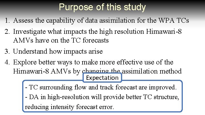
Purpose of this study 1. Assess the capability of data assimilation for the WPA TCs 2. Investigate what impacts the high resolution Himawari-8 AMVs have on the TC forecasts 3. Understand how impacts arise 4. Explore better ways to make more effective use of the Himawari-8 AMVs by changing the assimilation method Expectation - TC surrounding flow and track forecast are improved. - DA in high-resolution will provide better TC structure, reducing intensity forecast error.

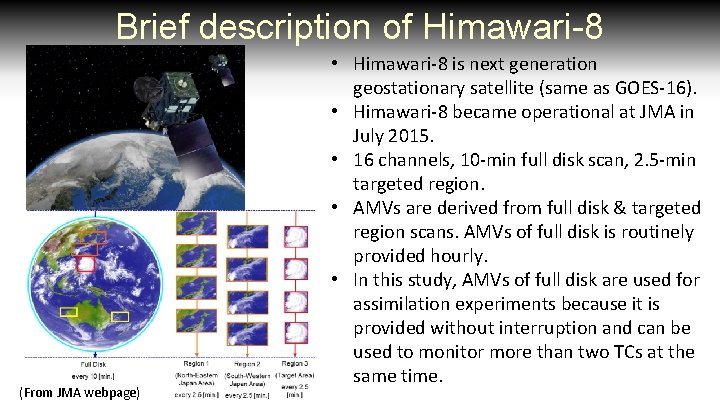
Brief description of Himawari-8 (From JMA webpage) • Himawari-8 is next generation geostationary satellite (same as GOES-16). • Himawari-8 became operational at JMA in July 2015. • 16 channels, 10 -min full disk scan, 2. 5 -min targeted region. • AMVs are derived from full disk & targeted region scans. AMVs of full disk is routinely provided hourly. • In this study, AMVs of full disk are used for assimilation experiments because it is provided without interruption and can be used to monitor more than two TCs at the same time.

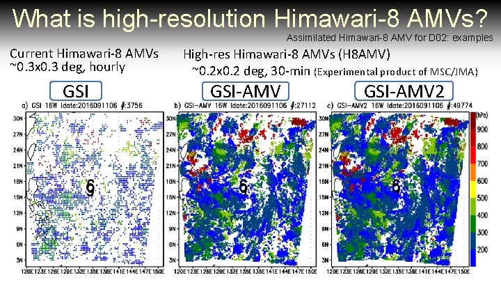
What is high-resolution Himawari-8 AMVs? Assimilated Himawari-8 AMV for D 02: examples Current Himawari-8 AMVs ~0. 3 x 0. 3 deg, hourly GSI High-res Himawari-8 AMVs (H 8 AMV) ~0. 2 x 0. 2 deg, 30 -min (Experimental product of MSC/JMA) GSI-AMV 2

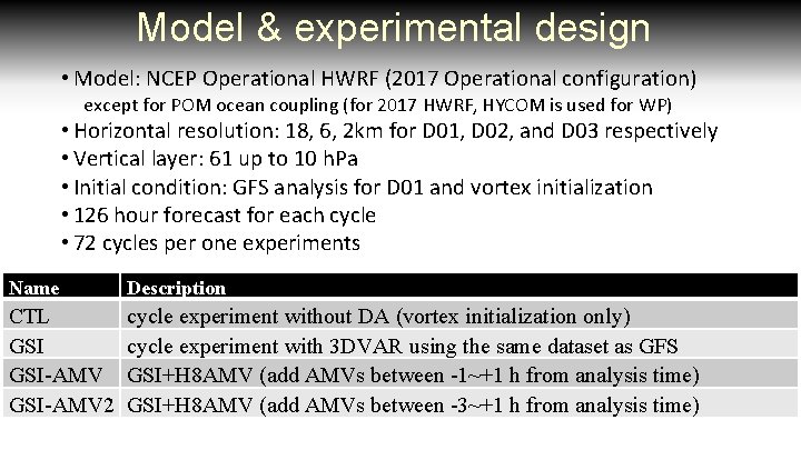
Model & experimental design • Model: NCEP Operational HWRF (2017 Operational configuration) except for POM ocean coupling (for 2017 HWRF, HYCOM is used for WP) • Horizontal resolution: 18, 6, 2 km for D 01, D 02, and D 03 respectively • Vertical layer: 61 up to 10 h. Pa • Initial condition: GFS analysis for D 01 and vortex initialization • 126 hour forecast for each cycle • 72 cycles per one experiments Name Description CTL GSI-AMV 2 cycle experiment without DA (vortex initialization only) cycle experiment with 3 DVAR using the same dataset as GFS GSI+H 8 AMV (add AMVs between -1~+1 h from analysis time) GSI+H 8 AMV (add AMVs between -3~+1 h from analysis time)

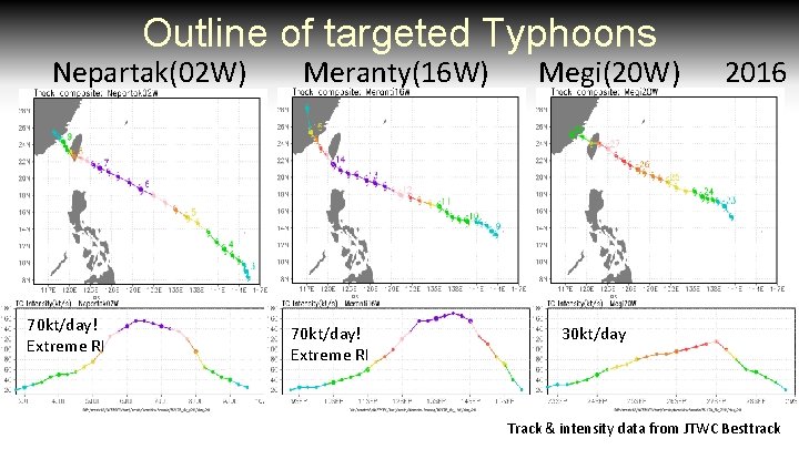
Outline of targeted Typhoons Nepartak(02 W) 70 kt/day! Extreme RI Meranty(16 W) 70 kt/day! Extreme RI Megi(20 W) 2016 30 kt/day Track & intensity data from JTWC Besttrack

• Track forecast Results • Track verification –all cases– • Track verification –each case– • Intensity forecast • Intensity verification –all cases– • Intensity verification –each case– • Size forecast • size verification –all cases– 11

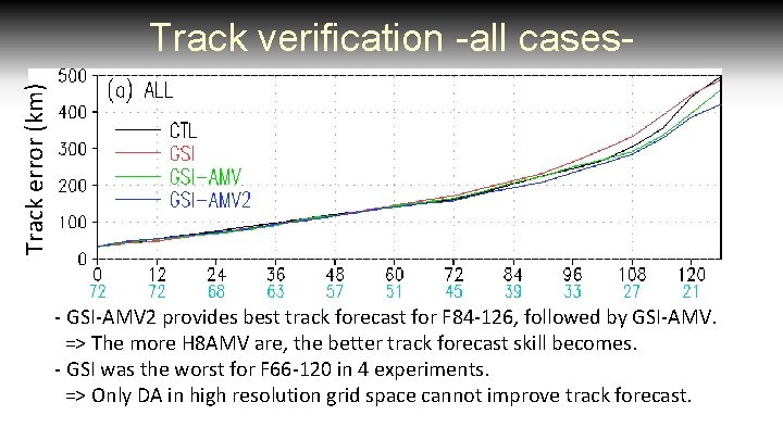
Track error (km) Track verification -all cases- - GSI-AMV 2 provides best track forecast for F 84 -126, followed by GSI-AMV. => The more H 8 AMV are, the better track forecast skill becomes. - GSI was the worst for F 66 -120 in 4 experiments. => Only DA in high resolution grid space cannot improve track forecast.

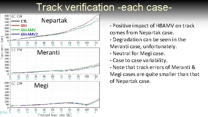
Track verification -each case. CTL GSI-AMV 2 Nepartak Meranti Megi - Positive impact of H 8 AMV on track comes from Nepartak case. - Degradation can be seen in the Meranti case, unfortunately. - Neutral for Megi case. - Case to case variability. - Note that track errors of Meranti & Megi cases are quite smaller than that of Nepartak case.

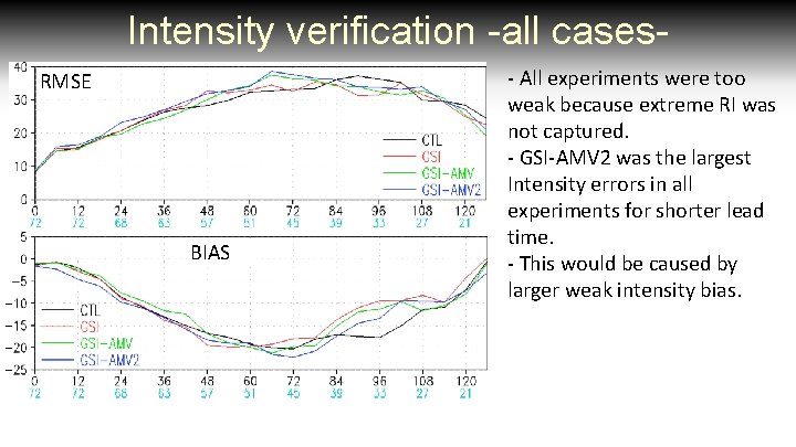
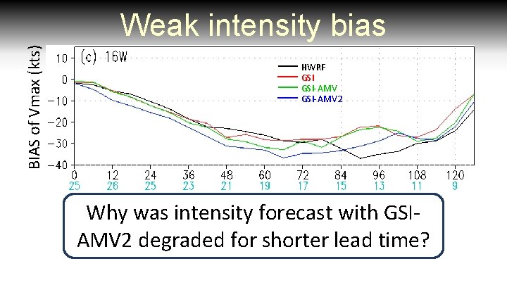
Intensity verification -all cases. RMSE HWRF GSI AMV 2 BIAS - All experiments were too weak because extreme RI was not captured. - GSI-AMV 2 was the largest Intensity errors in all experiments for shorter lead time. - This would be caused by larger weak intensity bias.

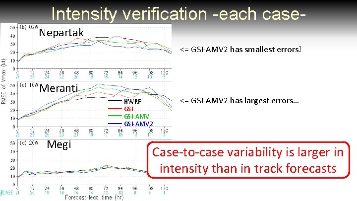
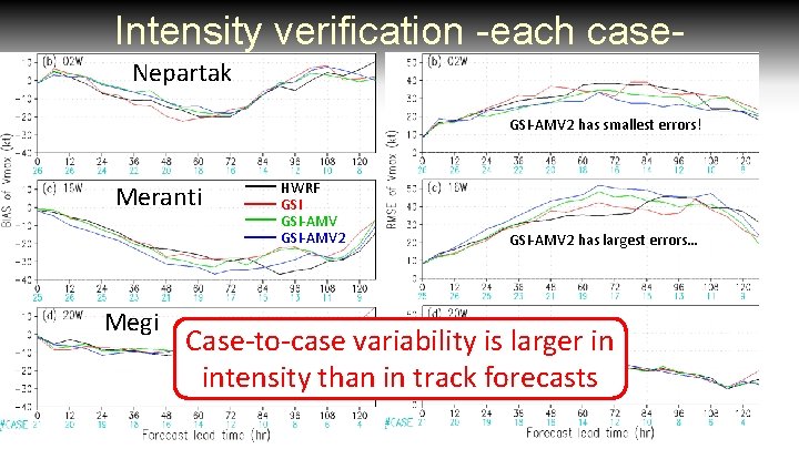
Intensity verification -each case. Nepartak <= GSI-AMV 2 has smallest errors! Meranti HWRF GSI-AMV 2 Megi <= GSI-AMV 2 has largest errors… Case-to-case variability is larger in intensity than in track forecasts

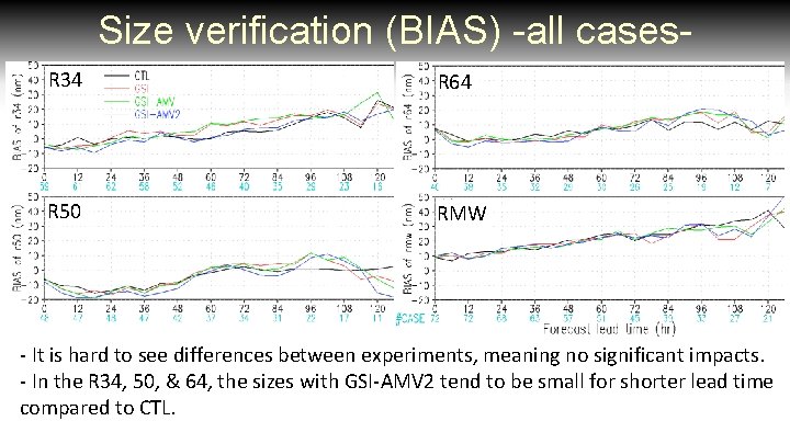
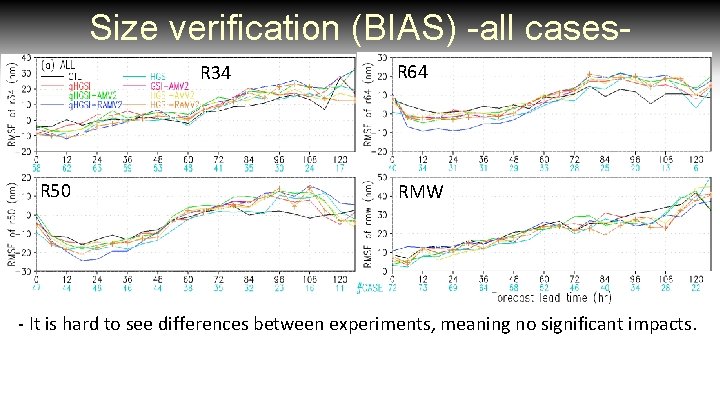
Size verification (BIAS) -all cases. R 34 HWRF R 64 GSI AMV 2 R 50 HWRF GSI AMV 2 RMW - It is hard to see differences between experiments, meaning no significant impacts. - In the R 34, 50, & 64, the sizes with GSI-AMV 2 tend to be small for shorter lead time compared to CTL.

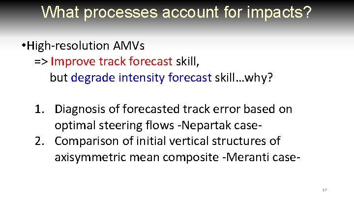
What processes account for impacts? • High-resolution AMVs => Improve track forecast skill, but degrade intensity forecast skill…why? 1. Diagnosis of forecasted track error based on optimal steering flows -Nepartak case 2. Comparison of initial vertical structures of axisymmetric mean composite -Meranti case 17

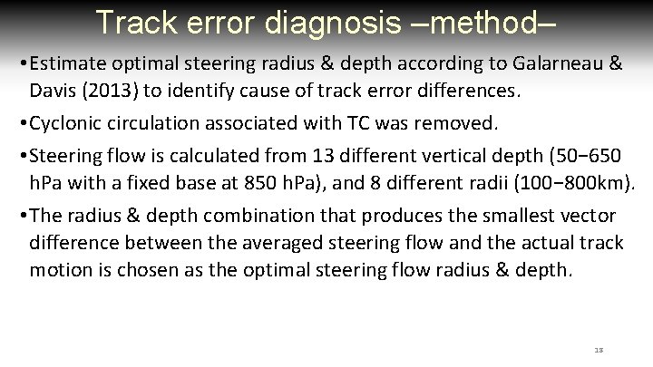
Track error diagnosis –method– • Estimate optimal steering radius & depth according to Galarneau & Davis (2013) to identify cause of track error differences. • Cyclonic circulation associated with TC was removed. • Steering flow is calculated from 13 different vertical depth (50− 650 h. Pa with a fixed base at 850 h. Pa), and 8 different radii (100− 800 km). • The radius & depth combination that produces the smallest vector difference between the averaged steering flow and the actual track motion is chosen as the optimal steering flow radius & depth. 18

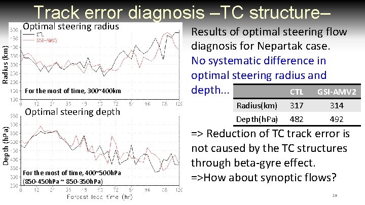
Track error diagnosis –TC structure– Radius (km) Optimal steering radius For the most of time, 300~400 km Depth (h. Pa) Optimal steering depth For the most of time, 400~500 h. Pa (850 -450 h. Pa ~ 850 -350 h. Pa) Results of optimal steering flow diagnosis for Nepartak case. No systematic difference in optimal steering radius and depth. . . CTL GSI-AMV 2 Radius(km) 317 314 Depth(h. Pa) 482 492 => Reduction of TC track error is not caused by the TC structures through beta-gyre effect. =>How about synoptic flows? 19

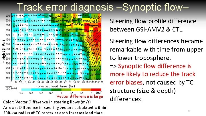
Track error diagnosis –Synoptic flow– Height (h. Pa) Steering flow profile difference between GSI-AMV 2 & CTL. Vector difference is large Color: Vector Difference in steering flows (m/s) Arrows: Difference in steering vectors calculated within 300 -km radius of TC center at each forecast lead time. Steering flow differences became remarkable with time from upper to lower troposphere. => Synoptic flow difference is more likely to reduce the track error biases, not caused by TC structure (size & depth) differences. 20

BIAS of Vmax (kts) Weak intensity bias HWRF GSI-AMV 2 Why was intensity forecast with GSIAMV 2 degraded for shorter lead time?

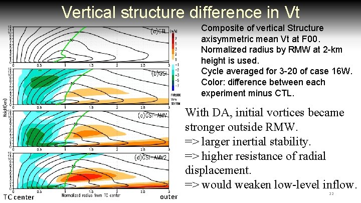
Vertical structure difference in Vt Composite of vertical Structure axisymmetric mean Vt at F 00. Normalized radius by RMW at 2 -km height is used. Cycle averaged for 3 -20 of case 16 W. Color: difference between each experiment minus CTL. With DA, initial vortices became stronger outside RMW. => larger inertial stability. => higher resistance of radial displacement. => would weaken low-level inflow. TC center outer 22

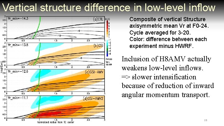
Vertical structure difference in low-level inflow Composite of vertical Structure axisymmetric mean Vr at F 0 -24. Cycle averaged for 3 -20. Color: difference between each experiment minus HWRF. Inclusion of H 8 AMV actually weakens low-level inflows. => slower intensification because of reduction of inward angular momentum transport. 23

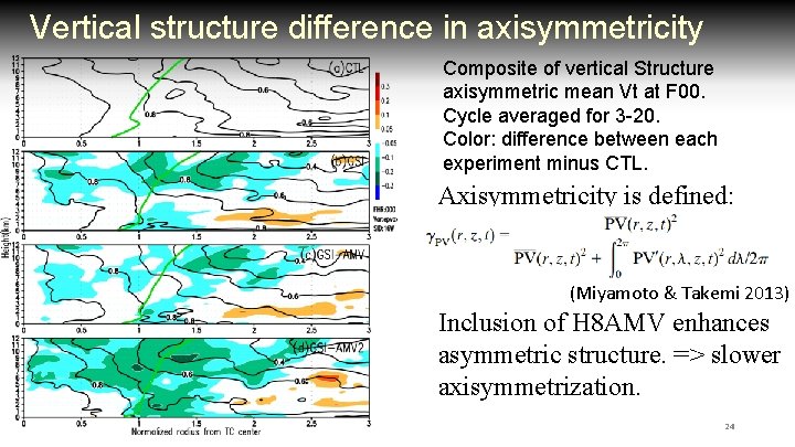
Vertical structure difference in axisymmetricity Composite of vertical Structure axisymmetric mean Vt at F 00. Cycle averaged for 3 -20. Color: difference between each experiment minus CTL. Axisymmetricity is defined: (Miyamoto & Takemi 2013) Inclusion of H 8 AMV enhances asymmetric structure. => slower axisymmetrization. 24

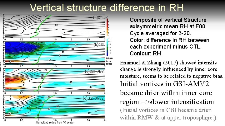
Vertical structure difference in RH Composite of vertical Structure axisymmetric mean RH at F 00. Cycle averaged for 3 -20. Color: difference in RH between each experiment minus CTL. Contour: RH Emanuel & Zhang (2017) showed intensity change is strongly influenced by inner core moisture, seems to be related to negative bias. Initial vortices in GSI-AMV 2 became drier within inner core region =>slower intensification (Initial vortices in GSI became drier within RMW & at upper troposphere. ) 25

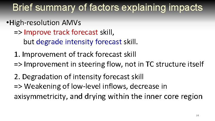
Brief summary of factors explaining impacts • High-resolution AMVs => Improve track forecast skill, but degrade intensity forecast skill. 1. Improvement of track forecast skill => Improvement in steering flow, not in TC structure itself 2. Degradation of intensity forecast skill => Weakening of low-level inflows, decrease in axisymmetricity, and drying within the inner core region 26

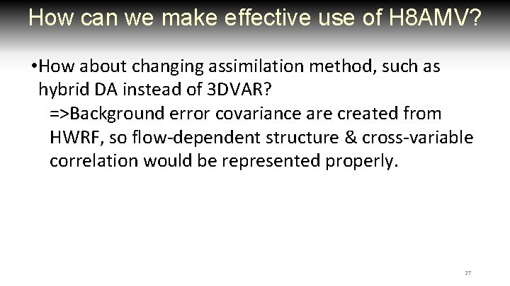
How can we make effective use of H 8 AMV? • How about changing assimilation method, such as hybrid DA instead of 3 DVAR? =>Background error covariance are created from HWRF, so flow-dependent structure & cross-variable correlation would be represented properly. 27

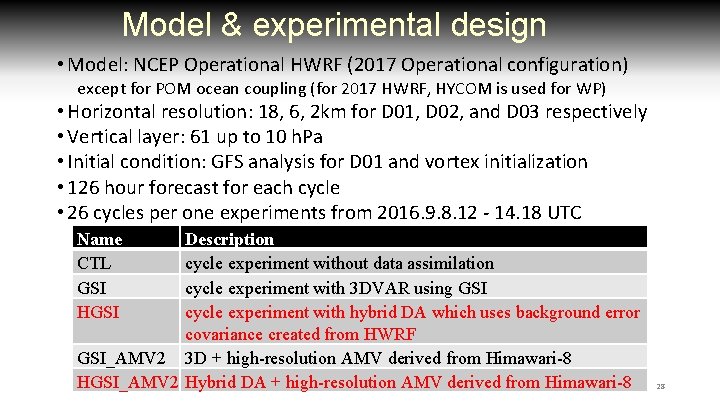
Model & experimental design • Model: NCEP Operational HWRF (2017 Operational configuration) except for POM ocean coupling (for 2017 HWRF, HYCOM is used for WP) • Horizontal resolution: 18, 6, 2 km for D 01, D 02, and D 03 respectively • Vertical layer: 61 up to 10 h. Pa • Initial condition: GFS analysis for D 01 and vortex initialization • 126 hour forecast for each cycle • 26 cycles per one experiments from 2016. 9. 8. 12 - 14. 18 UTC Name CTL GSI HGSI Description cycle experiment without data assimilation cycle experiment with 3 DVAR using GSI cycle experiment with hybrid DA which uses background error covariance created from HWRF GSI_AMV 2 3 D + high-resolution AMV derived from Himawari-8 HGSI_AMV 2 Hybrid DA + high-resolution AMV derived from Himawari-8 28

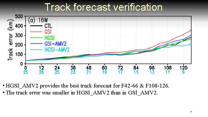
Track forecast verification • HGSI_AMV 2 provides the best track forecast for F 42 -66 & F 108 -126. • The track error was smaller in HGSI_AMV 2 than in GSI_AMV 2. 29

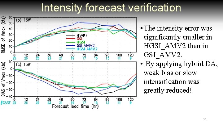
Intensity forecast verification HWRF GSI HGSI GSI-AMV 2 HGSI-AMV 2 • The intensity error was significantly smaller in HGSI_AMV 2 than in GSI_AMV 2. • By applying hybrid DA, weak bias or slow intensification was greatly reduced! 30

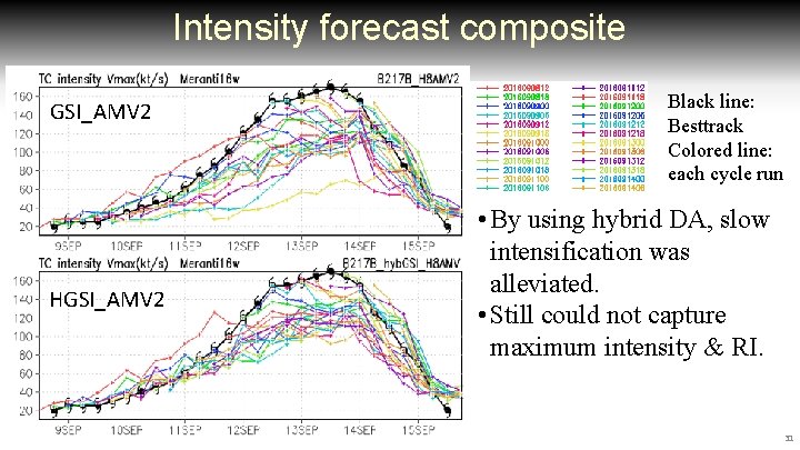
Intensity forecast composite GSI_AMV 2 HGSI_AMV 2 Black line: Besttrack Colored line: each cycle run • By using hybrid DA, slow intensification was alleviated. • Still could not capture maximum intensity & RI. 31

Why was intensity bias mitigated? • High-resolution AMVs (+ 3 DVAR) => Improve track forecast skill, but degrade intensity forecast skill. • High-resolution AMVs + hybrid DA => Improve track forecast skill, WITHOUT degradation of intensity forecast! Why? 32

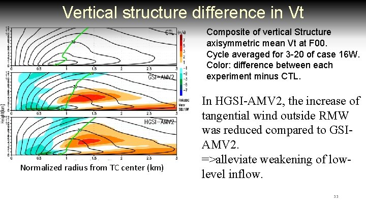
Vertical structure difference in Vt Composite of vertical Structure axisymmetric mean Vt at F 00. Cycle averaged for 3 -20 of case 16 W. Color: difference between each experiment minus CTL. Normalized radius from TC center (km) In HGSI-AMV 2, the increase of tangential wind outside RMW was reduced compared to GSIAMV 2. =>alleviate weakening of lowlevel inflow. 33

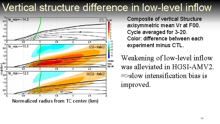
Vertical structure difference in low-level inflow Composite of vertical Structure axisymmetric mean Vr at F 00. Cycle averaged for 3 -20. Color: difference between each experiment minus CTL. Weakening of low-level inflow was alleviated in HGSI-AMV 2. =>slow intensification bias is improved. Normalized radius from TC center (km) 34

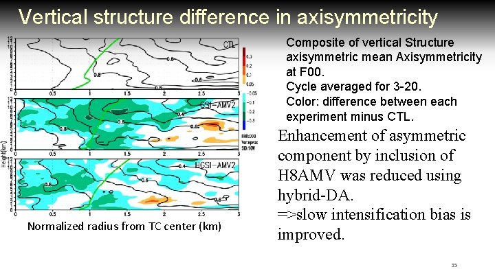
Vertical structure difference in axisymmetricity Composite of vertical Structure axisymmetric mean Axisymmetricity at F 00. Cycle averaged for 3 -20. Color: difference between each experiment minus CTL. Normalized radius from TC center (km) Enhancement of asymmetric component by inclusion of H 8 AMV was reduced using hybrid-DA. =>slow intensification bias is improved. 35

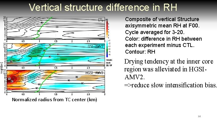
Vertical structure difference in RH Composite of vertical Structure axisymmetric mean RH at F 00. Cycle averaged for 3 -20. Color: difference in RH between each experiment minus CTL. Contour: RH Drying tendency at the inner core region was alleviated in HGSIAMV 2. =>reduce slow intensification bias. Normalized radius from TC center (km) 36

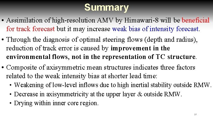
Summary • Assimilation of high-resolution AMV by Himawari-8 will be beneficial for track forecast but it may increase weak bias of intensity forecast. • Through the diagnosis of optimal steering flows (depth and radius), reduction of track error is caused by improvement in the environmental flows, not in the representation of TC structure. • Composite of axisymmetric mean structures indicates three factors related to the weak intensity bias at shorter lead time: • Weakening of low-level inflows due to high inertial stability outside RMW. • Decrease in axisymmetricity at the upper layer & outside RMW. • Drying within inner core region. 37

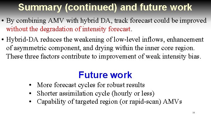
Summary (continued) and future work • By combining AMV with hybrid DA, track forecast could be improved without the degradation of intensity forecast. • Hybrid-DA reduces the weakening of low-level inflows, enhancement of asymmetric component, and drying within the inner core region. These three factors contribute to improvement of weak intensity bias. Future work • More forecast cycles for robust results • Shorter assimilation cycle (hourly or less) • Capability of targeted region (or rapid-scan) AMVs 38

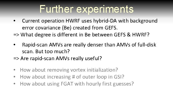
Further experiments Current operation HWRF uses hybrid-DA with background error covariance (Be) created from GEFS. => What degree is different in Be between GEFS & HWRF? • Rapid-scan AMVs are really denser than AMVs of full-disk scan. But too much? => Are rapid-scan AMVs really useful? • • How about removing vortex initialization? • How about increasing # of outer loop in GSI? • How about using FGAT with hourly first guesses?

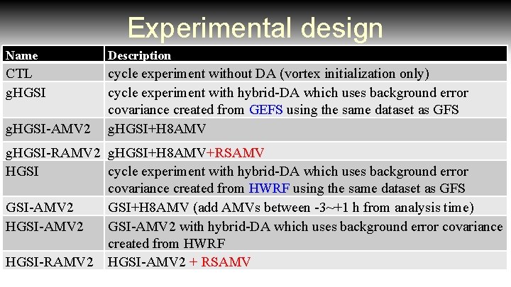
Experimental design Name Description CTL g. HGSI cycle experiment without DA (vortex initialization only) cycle experiment with hybrid-DA which uses background error covariance created from GEFS using the same dataset as GFS g. HGSI+H 8 AMV g. HGSI-AMV 2 g. HGSI-RAMV 2 g. HGSI+H 8 AMV+RSAMV HGSI cycle experiment with hybrid-DA which uses background error covariance created from HWRF using the same dataset as GFS GSI-AMV 2 GSI+H 8 AMV (add AMVs between -3~+1 h from analysis time) HGSI-AMV 2 with hybrid-DA which uses background error covariance created from HWRF HGSI-RAMV 2 HGSI-AMV 2 + RSAMV

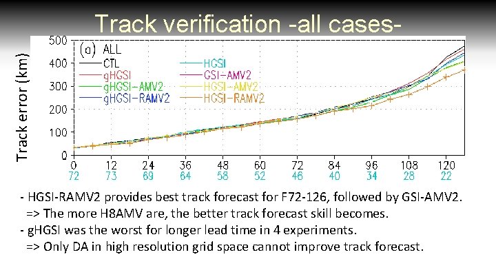
Track error (km) Track verification -all cases- - HGSI-RAMV 2 provides best track forecast for F 72 -126, followed by GSI-AMV 2. => The more H 8 AMV are, the better track forecast skill becomes. - g. HGSI was the worst for longer lead time in 4 experiments. => Only DA in high resolution grid space cannot improve track forecast.

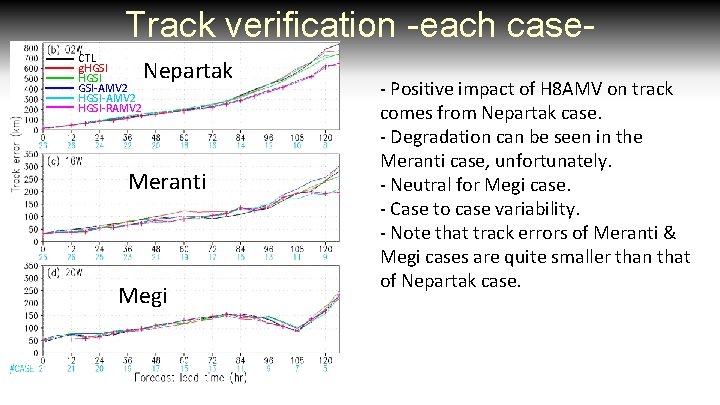
Track verification -each case. CTL g. HGSI GSI-AMV 2 HGSI-RAMV 2 Nepartak Meranti Megi - Positive impact of H 8 AMV on track comes from Nepartak case. - Degradation can be seen in the Meranti case, unfortunately. - Neutral for Megi case. - Case to case variability. - Note that track errors of Meranti & Megi cases are quite smaller than that of Nepartak case.

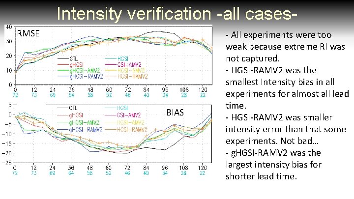
Intensity verification -all cases. RMSE BIAS - All experiments were too weak because extreme RI was not captured. - HGSI-RAMV 2 was the smallest Intensity bias in all experiments for almost all lead time. - HGSI-RAMV 2 was smaller intensity error than that some experiments. Not bad… - g. HGSI-RAMV 2 was the largest intensity bias for shorter lead time.

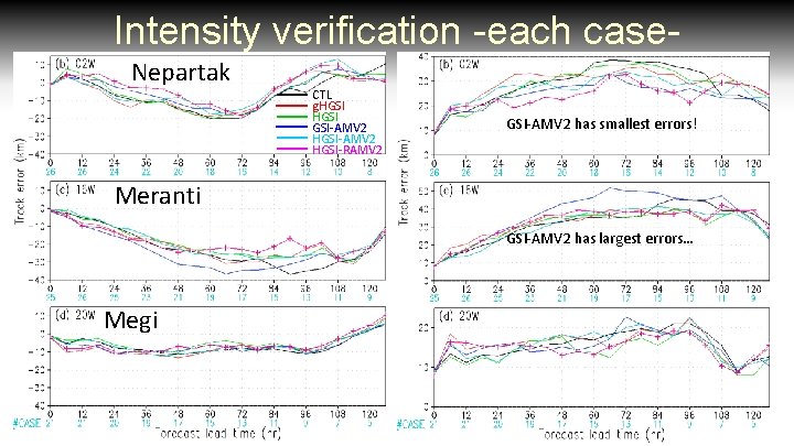
Intensity verification -each case. Nepartak CTL g. HGSI GSI-AMV 2 HGSI-RAMV 2 GSI-AMV 2 has smallest errors! Meranti GSI-AMV 2 has largest errors… Megi

Size verification (BIAS) -all cases. R 34 R 50 R 64 RMW - It is hard to see differences between experiments, meaning no significant impacts.


Intensity verification -each case. Nepartak GSI-AMV 2 has smallest errors! Meranti Megi HWRF GSI-AMV 2 has largest errors… Case-to-case variability is larger in intensity than in track forecasts

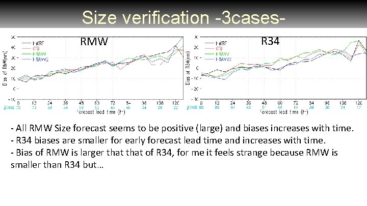
Size verification -3 cases. RMW R 34 - All RMW Size forecast seems to be positive (large) and biases increases with time. - R 34 biases are smaller for early forecast lead time and increases with time. - Bias of RMW is larger that of R 34, for me it feels strange because RMW is smaller than R 34 but…

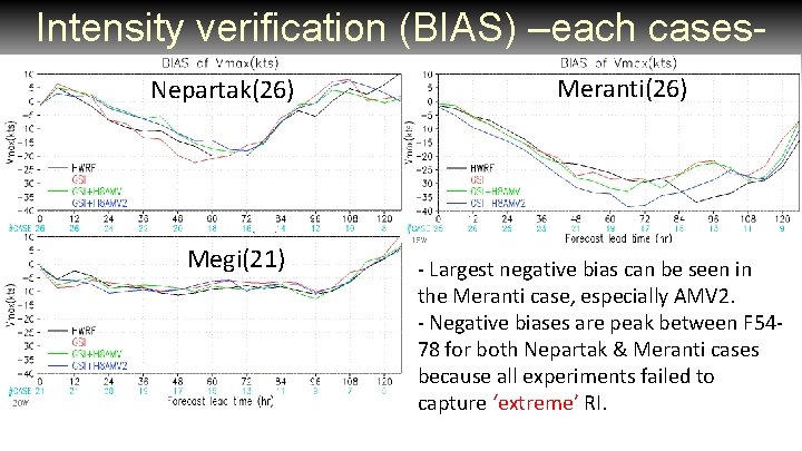
Intensity verification (BIAS) –each cases. Nepartak(26) Megi(21) Meranti(26) - Largest negative bias can be seen in the Meranti case, especially AMV 2. - Negative biases are peak between F 5478 for both Nepartak & Meranti cases because all experiments failed to capture ‘extreme’ RI.

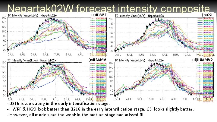
Nepartak 02 W forecast intensity composite (a)HWRF (b)GSI (c)H 8 AMV (d)H 8 AMV 2 - B 216 is too strong in the early intensification stage. - HWRF & HGSI look better than B 216 in the early intensification stage. GSI looks slightly better. - However, all models are too weak in the mature stage and missed RI.

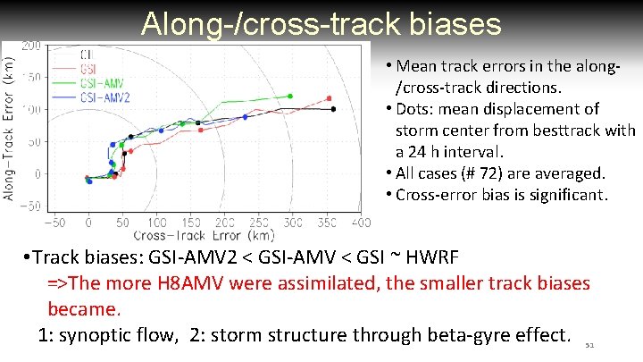
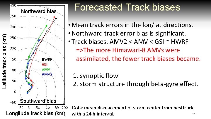
Along-/cross-track biases • Mean track errors in the along/cross-track directions. • Dots: mean displacement of storm center from besttrack with a 24 h interval. • All cases (# 72) are averaged. • Cross-error bias is significant. • Track biases: GSI-AMV 2 < GSI-AMV < GSI ~ HWRF =>The more H 8 AMV were assimilated, the smaller track biases became. 1: synoptic flow, 2: storm structure through beta-gyre effect. 51

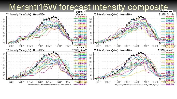
Meranti 16 W forecast intensity composite (a)B 216 (b)HWRF (c)GSI (d)HGSI Replacement is needed!!! - B 216 is too strong in the early intensification stage. - HWRF & HGSI look better than B 216 in the early intensification stage. GSI looks slightly better. - However, all models are too weak in the mature stage and missed RI.

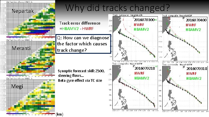
Why did tracks changed? Nepartak Track error difference =H 8 AMV 2 - HWRF Meranti Megi 2016070300 HWRF H 8 AMV 2 2016070400 HWRF H 8 AMV 2 2016070218 HWRF H 8 AMV 2 2016070318 HWRF H 8 AMV 2 Q: How can we diagnose the factor which causes track change? Synoptic forecast skill: Z 500, steering flows… Beta gyre effect via TC size (km)

Latitude track bias (km) Northward bias HWRF GSI AMV 2 Forecasted Track biases • Mean track errors in the lon/lat directions. • Northward track error bias is significant. • Track biases: AMV 2 < AMV < GSI ~ HWRF =>The more Himawari-8 AMVs were assimilated, the fewer track biases became. 1. synoptic flow. 2. storm structure through beta-gyre effect. Southward bias Longitude track bias (km) Dots: mean displacement of storm center from besttrack 54 with a 24 h interval.