Chapter 11 Weather Radar n n Radar was
- Slides: 23

Chapter 11 Weather Radar

n n Radar was first developed in World War II to aid in spotting distant ships and airplanes. It was noticed that during disturbed weather conditions a kind of widespread interference often appeared on the radar screen. In the 1940 s, many theoretical and experimental work showed that this “weather clutter” arose from the scattering of radar waves by precipitation. Now most radar signals—amplitude, phase polarization, and frequency—can be interpreted in terms of the sizes, shape, motions, or thermodynamic phase of the precipitation particles. Because of radar’s ability to observe and measure precipitation quickly, accurately, and from great distances, radars have become essential in cloud physics research and in weather observation and forecasting. Many radar systems have been designed and constructed specifically for meteorological applications.

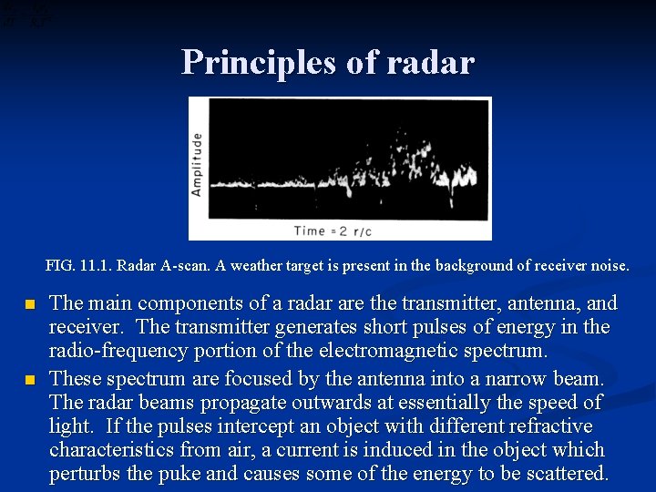
Principles of radar FIG. 11. 1. Radar A-scan. A weather target is present in the background of receiver noise. n n The main components of a radar are the transmitter, antenna, and receiver. The transmitter generates short pulses of energy in the radio-frequency portion of the electromagnetic spectrum. These spectrum are focused by the antenna into a narrow beam. The radar beams propagate outwards at essentially the speed of light. If the pulses intercept an object with different refractive characteristics from air, a current is induced in the object which perturbs the puke and causes some of the energy to be scattered.

Principles of radar n n n Part of the scattered energy will generally be directed back toward the antenna, and if this backscattered component is sufficiently large it will be detected by the receiver. The function of radar is to measure the range and bearing of backscattering objects or “targets”. Ranging is accomplished by counting the time between the transmission of a pulse and the reception of a signal. Direction is determined by noting the antenna azimuth and elevation at the instant the signal is received. The basic radar display is the A-scope, an oscillograph trace of returned signal amplitude versus time after pulse transmission, as shown in Fig. 11. 1. Because the energy travels with velocity c, the time interval t between transmission and reception is related to target range by r = ct/2. The factor l/2 arises because the energy must make a round trip to range r in time t.

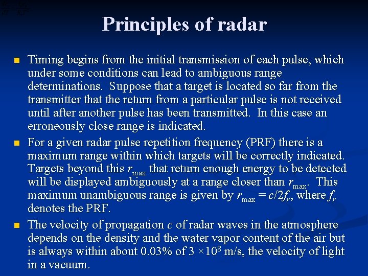
Principles of radar n n n Timing begins from the initial transmission of each pulse, which under some conditions can lead to ambiguous range determinations. Suppose that a target is located so far from the transmitter that the return from a particular pulse is not received until after another pulse has been transmitted. In this case an erroneously close range is indicated. For a given radar pulse repetition frequency (PRF) there is a maximum range within which targets will be correctly indicated. Targets beyond this rmax that return enough energy to be detected will be displayed ambiguously at a range closer than rmax. This maximum unambiguous range is given by rmax = c/2 fr, where fr denotes the PRF. The velocity of propagation c of radar waves in the atmosphere depends on the density and the water vapor content of the air but is always within about 0. 03% of 3 × 10⁸ m/s, the velocity of light in a vacuum.

Principles of radar n n n The atmosphere is stratified so that c is slightly less near the ground than at higher altitudes. This increase of c with altitude causes a downward refraction of waves propagating in directions close to the horizontal. For a standard atmosphere, the radar ray paths are approximately circular arcs with a radius of curvature somewhat grater than that of the earth. Thus, the radar horizon is located slightly beyond the optical horizon in a standard atmosphere. If objects in the atmosphere are too distant horizontally and lost in the earth’s shadow, they are invisible to radar as they are to the eye. When the atmospheric vertical structure deviates significantly from the standard conditions (like the case of strong inversions or elevated moist layers), anomalous propagation can occur. Abnormal downward bending of the radar waves (“superrefraction”) is a kind of anomalous propagation that occasionally confuses the interpretation of weather echoes.

Principles of radar n n Some important radar parameters, and their range of values for typical weather radars, are as follows: (1) Peak power (the instantaneous power in a pulse), Pt : 10 < Pt < 103 k. W (2) Radio frequency, ν: 3 < ν < 30 GHz (corresponding to wavelengths between 1 and 10 cm) (3) PRF, fr: 200 < fr < 2, 000 s– 1 (4) Pulse duration, τ: 0. 1 < τ < 5 μs. Additional important radar parameter is the beamwidth, which is determined by the wavelength and the antenna size and shape. Beamwidth is defined with respect to antenna pattern, a plot of the radiated intensity as a function of angular distance from beam

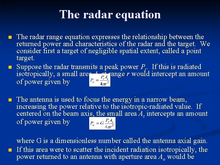
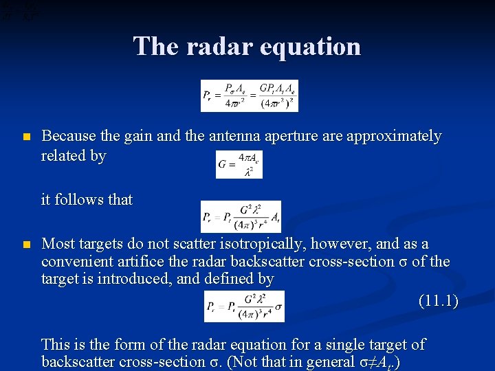
The radar equation n n The radar range equation expresses the relationship between the returned power and characteristics of the radar and the target. We consider first a target of negligible spatial extent, called a point target. Suppose the radar transmits a peak power Pt. If this is radiated isotropically, a small area At at range r would intercept an amount of power given by The antenna is used to focus the energy in a narrow beam, increasing the power relative to the isotropic-radiated value. If centered on the beam axis, the small area At intercepts an amount of power given by where G is a dimensionless number called the antenna axial gain. If this area were to scatter the incident radiation isotropically, the power returned to an antenna with aperture area Ae would be

The radar equation n Because the gain and the antenna aperture approximately related by it follows that n Most targets do not scatter isotropically, however, and as a convenient artifice the radar backscatter cross-section σ of the target is introduced, and defined by (11. 1) This is the form of the radar equation for a single target of backscatter cross-section σ. (Not that in general σ≠A. )

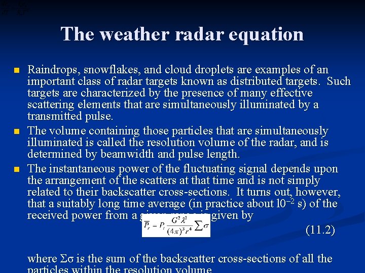
The weather radar equation n Raindrops, snowflakes, and cloud droplets are examples of an important class of radar targets known as distributed targets. Such targets are characterized by the presence of many effective scattering elements that are simultaneously illuminated by a transmitted pulse. The volume containing those particles that are simultaneously illuminated is called the resolution volume of the radar, and is determined by beamwidth and pulse length. The instantaneous power of the fluctuating signal depends upon the arrangement of the scatters at that time and is not simply related to their backscatter cross-sections. It turns out, however, that a suitably long time average (in practice about l 0– 2 s) of the received power from a given range is given by (11. 2) where Σσ is the sum of the backscatter cross-sections of all the

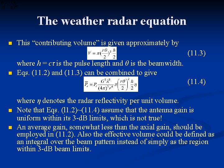
The weather radar equation n This “contributing volume” is given approximately by (11. 3) n where h = cτ is the pulse length and θ is the beamwidth. Eqs. (11. 2) and (11. 3) can be combined to give (11. 4) n n where η denotes the radar reflectivity per unit volume. Note that Eqs. (l 1. 2)~(11. 4) assume that the antenna gain is uniform within its 3 -d. B limits, which is not true! An average gain, somewhat less than the axial gain, should be employed in (11. 2). Also the effective volume could be defined as an integral over the beam pattern instead of simply as the region within 3 -d. B beam limits.

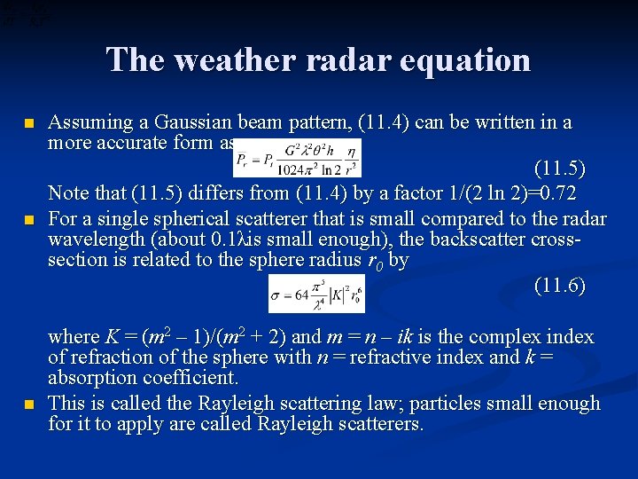
The weather radar equation n Assuming a Gaussian beam pattern, (11. 4) can be written in a more accurate form as (11. 5) Note that (11. 5) differs from (11. 4) by a factor 1/(2 ln 2)=0. 72 For a single spherical scatterer that is small compared to the radar wavelength (about 0. 1λis small enough), the backscatter crosssection is related to the sphere radius r 0 by (11. 6) where K = (m 2 – 1)/(m 2 + 2) and m = n – ik is the complex index of refraction of the sphere with n = refractive index and k = absorption coefficient. This is called the Rayleigh scattering law; particles small enough for it to apply are called Rayleigh scatterers.

The weather radar equation n Raindrops and snowflakes may be regarded as Rayleigh scatterers to good approximation at wavelengths of 5 cm (C-band) and 10 cm (S-band), which are common for weather radars. At 3 cm (Xband), also a popular wavelength, the approximation is still used but is less accurate. Large hailstones deviate from Rayleigh scattering behavior even at the long wavelength of l 0 cm. The refraction term K in (11. 6) depends on temperature, wavelength, and the composition of the sphere. For the wavelengths employed in weather radars, and over the meteorological range of temperatures, 0. 93 for water and 0. 21 for ice. Therefore an ice sphere has a radar cross-section only about 2/9, or 6. 5 d. B less than, that of a water sphere of the same size. For a collection of spherical raindrops small compared with the wavelength, which are shuffling about, the average received

The weather radar equation n n where Σ again is a summation over the contributing volume. In terms of the drop diameters Thus for spherical scatterers small with respect to the wavelength, the mean power received is determined by radar parameters, range, and by only two factors that depend upon the scatterers: the value of and the quantityΣD 6. Because of the significance of this quantityΣD 6 a new quantity Z is introduced, defined by (11. 7) where Σν denotes a summation over unit volume and N(D)d. D is the number of scatterers per unit volume with diameters in d. D.

The weather radar equation n n Note that in the definition of Z in the case of raindrops, N(D) is the drop-size distribution; for snowflakes, N(D) is the distribution of melted diameters. In terms of Z, the radar equation, including the small correction for Gaussian beam pattern, becomes (11. 8) RADAR TARGET Following (11. 8), the received power may be related to the reflectivity factor Z by (11. 9) where C is a constant determined by radar parameters and the dielectric character of the target. * In logarithmic form of Eq. (11. 9), the power in decibels is related to the reflectivity factor as measured on a decibel scale. n

The weather radar equation n Usual conventions are that is measured in milliwatts, with the quantity called the power in d. Bm (decibels relative to a milliwatt), and Z is measured in mm 6/m 3 with the quantity l 0 log Z called the reflectivity factor in d. BZ. The logarithmic version of the equation is useful because of the wide ranges over which and Z vary. Some energy is lost from a radar beam by absorption and scattering by atmospheric constituents. Clouds and precipitation absorb and scatter a fraction of the microwave energy incident upon them; the gaseous constituents ( O 2 and H 2 O) absorb weakly over the radar microwave spectrum. These attenuation effects (more severe for shorter wavelength) depend on the radar wavelength. For quantitative measurements of reflectivity, the attenuation due to scattering and absorption should be taken into account. Hence relatively long wavelengths of 5 cm (C band) and l 0 cm (S bans)

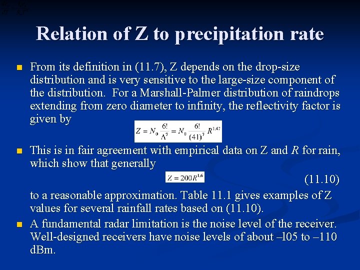
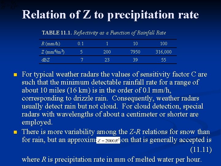
Relation of Z to precipitation rate n From its definition in (11. 7), Z depends on the drop-size distribution and is very sensitive to the large-size component of the distribution. For a Marshall-Palmer distribution of raindrops extending from zero diameter to infinity, the reflectivity factor is given by n This is in fair agreement with empirical data on Z and R for rain, which show that generally (11. 10) to a reasonable approximation. Table 11. 1 gives examples of Z values for several rainfall rates based on (11. 10). A fundamental radar limitation is the noise level of the receiver. Well-designed receivers have noise levels of about –l 05 to – 110 d. Bm. n

Relation of Z to precipitation rate TABLE 11. 1. Reflectivity as a Function of Rainfall Rate R (mm/h) n n 0. 1 1 10 100 Z (mm 6/m 3) 5 200 7950 316, 000 d. BZ 7 23 39 55 For typical weather radars the values of sensitivity factor C are such that the minimum detectable rainfall rate for a range of about 10 miles (16 km) is in the order of 0. l mm/h, corresponding to drizzle rain. Consequently, weather radars usually detect rain but not cloud. For cloud detection, special radars with wavelengths of about a centimeter or shorter are employed. There is more variability among the Z-R relations for snow than for rain, but an approximate relation that is generally accepted is (11. 11) where R is precipitation rate in mm of melted water per hour.

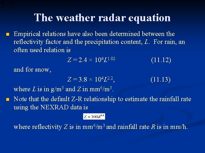
The weather radar equation n n Empirical relations have also been determined between the reflectivity factor and the precipitation content, L. For rain, an often used relation is Z = 2. 4 × 10⁴ L 1. 82 (11. 12) and for snow, Z = 3. 8 × 10⁴ L 2. 2, (11. 13) where L is in g/m 3 and Z in mm 6/m 3. Note that the default Z-R relationship to estimate the rainfall rate using the NEXRAD data is where reflectivity Z is in mm 6/m 3 and rainfall rate R is in mm/h.

Radar displays and special techniques n n n The PPI (Plan Position Indicator) mode maps the received signals or “echoes” on polar coordinates in plan view. With elevation angle fixed, the antenna scans 360 o in azimuth with the beam sweeping across a conical surface in space. The distribution of precipitation in plan view is produced, and a time sequence of PPIs indicates the development and motion of precipitation areas. Without careful calibration procedures, PPI records just show where and when precipitation is occurring and indicate roughly where the rain is relatively intense (bright echoes). This information in itself is useful in synoptic meteorology, but of limited value in quantitative precipitation studies. Thus it is desirable to know the actual distribution of Z within the echoes. The RHI (Range Height Indicator) mode is used when the antenna scans in elevation with azimuth angle fixed, showing

Radar displays and special techniques n n n Without careful calibration procedures, PPI records just show where and when precipitation is occurring and indicate roughly where the rain is relatively intense (bright echoes). This information in itself is useful in synoptic meteorology, but of limited value in quantitative precipitation studies. Thus it is desirable to know the actual distribution of Z within the echoes. The RHI (Range Height Indicator) mode is used when the antenna scans in elevation with azimuth angle fixed, showing the details of vertical structure of radar echoes. 3 D echo coverage can be achieved by a series of antenna scan, in which azimuth and elevation are systematically varied to survey all space around the radar site. Some interpolation techniques are used to convert the data from a series of conical scans to produce constant-altitude PPI (CAPPI) maps at several constant vertical levels. A 3 D volume scan usually takes 5~15 min.

Radar displays and special techniques n n It is now common for the radar transmitter to be coherent, meaning that the frequency of the transmitted signal is constant and that each pulse bears the same phase relation to its predecessor (like the klystron transmitter). If the frequency content of the returned signal is compared with that of the transmitted signal and frequency shift are interpreted as arising from the Doppler effect by a velocity according to where denotes a unit vector in the radial direction, and , the radial velocity. Raindrops/snowflakes induce a spectrum of Doppler shifts because they generally do not all move with the same velocity. When radar beam is pointed vertically, the Doppler velocity contains information about vertical air motions and precipitation

Radar displays and special techniques n n n For horizontal viewing, Doppler velocities are interpreted as arising from horizontal air motions. The scattering rain/snow particles move with the wind to a close approximation, though the radar echoes do not move exactly with the wind. It is also possible to derive information about the target by comparing the polarization of the received and transmitted waves (polarmetric radar). Non-symmetrical scattering objects induce an amount of cross-polarization depending in a complex way on their shapes, sizes, and dielectric properties. For precipitation, a theory has been developed which relates the cross polarization to the axial ratio of the particles, which are approximated as ellipsoids small compared to the wavelength. There is increasing evidence that polarization techniques provide a method of distinguishing between rain and other precipitation forms (Rogers, 1984).