Atmosphere and Weather Evaluation of Atmosphere Early atmosphere


 - deflect from a straight line observed because of")
 to deflect to the right (Southern Hemisphere")


 Formed over land at low latitudes transports warm")


")
 Most common type Very large clusters of")


- Slides: 65
Atmosphere and Weather
§Evaluation of Atmosphere §Early atmosphere composed of H and He No free O §Next atmosphere formed by gases trapped in hot interior – probability H 2 O vapor and CO 2 with trace elements, N, NH 3 , SO 2 §Early plants used photosynthesis to form O 2 §CO 2 + H 2 O + light energy CH 2 O + O 2
§ Makeup of Atmosphere § § Depends upon gravity • Gases are compressible • Density of air molecules greatest near surface, decreases with height • weight of air exerts pressure know as air pressure or atmospheric pressure, pressure greater at surface Gases of the Atmosphere • Two gases make up the bulk of the earth's atmosphere: nitrogen (N 2), which comprises 78% of the atmosphere, and oxygen (O 2), which accounts for 21%. Various trace gases make up the remainder.
üPermanent Gases – or Constant gases • Nitrogen 78 • Oxygen 21 • Argon. 9 • Neon. 0018 • Helium. 0005 • Methane. 0001 • Hydrogen. 00005 üVariable Gases • H 2 0 • CO 2 • CO • O 3 • SO 2 • NO 2
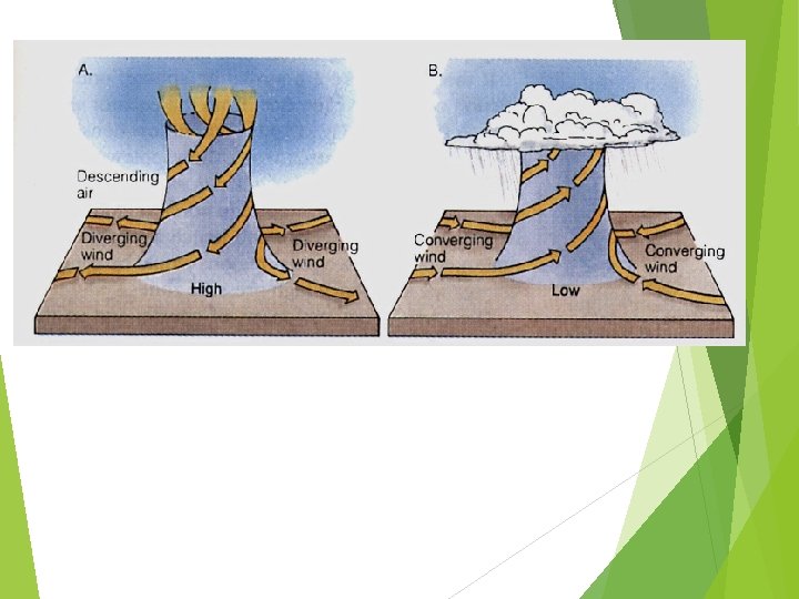
§atmospheric pressure üAs you decrease your altitude air pressure increases. Because there is more air on top of you. §Atmospheric pressure is normally measured in units called millibars (mb). One millibar is equal to 1 gram per centimeter squared (1 g/cm 2). üAt sea level, the average air pressure is 1, 013 mb. At the top of Mt. Everest the air pressure can get as low as 300 mb. üThe amount of oxygen in the atmosphere is decreased at higher elevations because of the lower air pressure, as the pressure of gases such as oxygen is related to density. That means there is only about 1/3 as much oxygen on Mt. Everest as there is at sea level. This is why many people who attempt to climb Mt. Everest experience shortness of breath as they climb to higher elevations. Descending air forms high pressure centers or divergence.
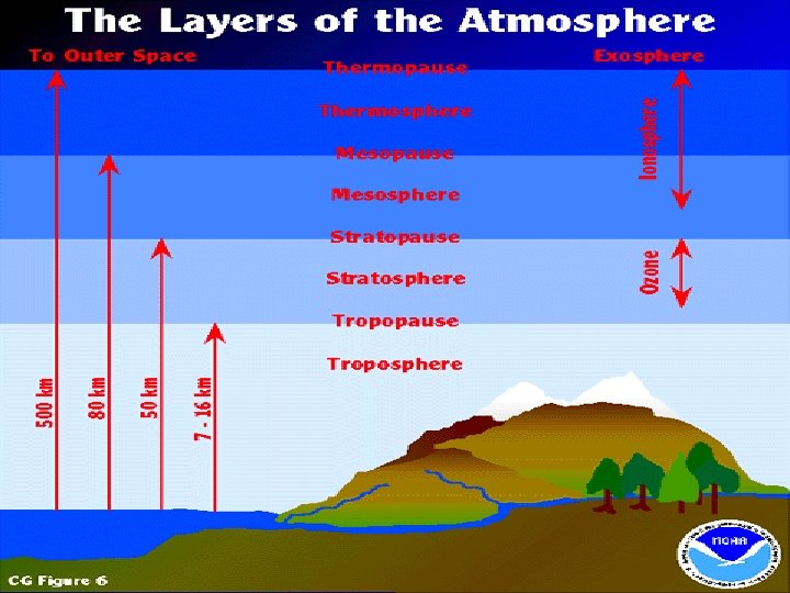
• Atmosphere is a very thin layer wrapped around a very large planet. §Based on temperature, the atmosphere is divided into layers: ü Troposphere • Weather occurs • 90% of atmosphere's mass – water vapor • Height of about 16 km (equator, - 8 km over poles) • Temp. As height about 6 o C / Km ü Stratosphere • about 50 km above the surface • O 3 forms • temp. to about 0 o C because of absorption of UV
ü Mesosphere • about 80 km • Absorb little UV – very cold ü Thermosphere • very little air – to about 500 km • Contains ionosphere – ion rich region • Ions produced by solar radiation with atoms of atmosphere gases – depends upon amount of air and solar radiation. • Aurora Borealis near poles seen (seeing ions)
üExosphere • way up there – above 500 km §What’s Greenhouse effect? • warming of the lower atmosphere • Occurs naturally – by volcanic eruptions • Water vapor is largest gas that holds in heat • increase of CO 2 and other gases increase the atmosphere’ ability to absorb and trap heat energy • Causes change in climate
§Energy is transferred between the earth's surface and the atmosphere via conduction, convection, and radiation. üConduction –touch üRadiation –waves üConvection -
§warm air that cold air to replace the hot air üthis thermal circulation of air is a convection current üthis creates a pressure difference üwind is generated in response to pressure differences cause by temperature differences üthe difference in pressure between 2 locations is called a pressure gradient - this force that causes air to move is pressure-gradient force – drives air from high pressure areas to low pressure areas important stuff
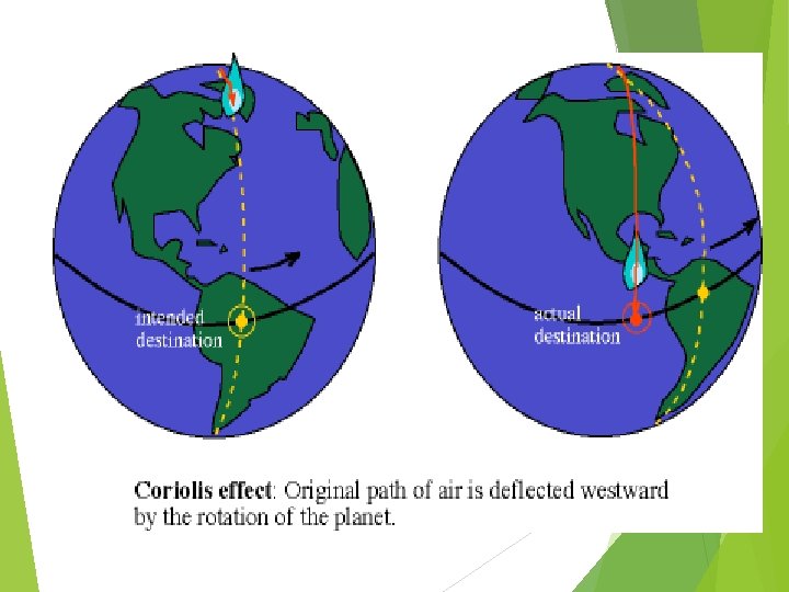
ü Coriolis effect (force) - deflect from a straight line observed because of the earth’s rotation
• causes wind (movement of air) to deflect to the right (Southern Hemisphere to the left) • Faster wind, greater deflection • Deflection is greater at poles… 0 a equator • Cause winds to spiral out of H pressure and spiral in at a L pressure ücauses the different air masses created by the unequal heating of the planet’s surface to shift direction
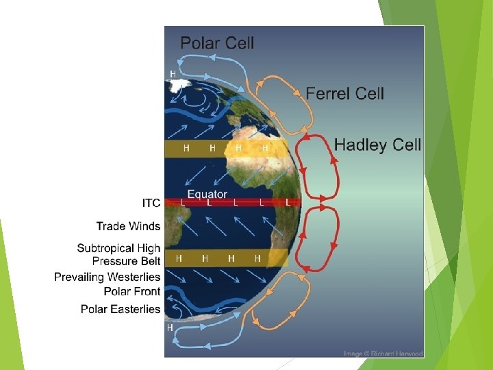
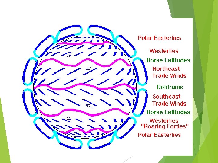
üThis creates the three main wind belts found at the surface of each hemisphere including the easterly trade winds, prevailing westerlies and the polar easterlies.
Global Wind patterns Subpolar low Horse latitudes doldrums Horse latitudes Subpolar low
§Planetary Winds –Global scale winds are – winds that are created in the different Global circulation Cells. you have the: • Polar Easterlies -The polar easterlies blow from the Pole to 600 • Prevailing Westerlies - The Prevailing Westerlies blow from 600 to 30 0 • Trade Winds - The Trade Winds blow from 300 to 00
§Polar highs result from the descent of cold air and its movement towards onto the surface. • Subtropical highs form as cool air descends towards the surface. “This air is very dry making surface conditions in these regions very arid. Most of the world’s deserts in both hemispheres are found in this latitude range. ” High pressure cells move in a clockwise direction
Ascending air forms low-pressure systems or areas of convergence. Tropical lows form as warm air ascends up into the atmosphere. Sub polar lows form as warm air in the 50 -60° latitude ranges of both hemispheres rises producing abundant precipitation. Low-pressure cells move in a counterclockwise direction.
§Air tends to move from areas of high to low pressure. § Air is denser and highly concentrated in highpressure cells, which means it is drier. §Air is less dense in low-pressure cells, which means that it is capable of holding (occupy) more moisture.
Water in the Atmosphere §Humidity üMeasure of water vapor in the air – Its about Energy – how much heat energy can keep H 2 O vaporized-Evaporation Energy üRelative humidity – depends on temperature ü% humidity mean that there is _____ % that the air can occupy H 2 O vapor at that temperature üSaturated - when air contains as much water vapor as can occupy – occurs when air cools üDew point – temp. at which air becomes saturated
ü As air rises, it cools and condenses ü As air cools water molecules move slower and condensation occurs. ü Precipitation occurs – needs a nuclei to form – smoke, dust, salt, etc ü When the particles get big enough then they fall ü There are 3 weather variables 1. Air Pressure 2. Temperature 3. Density These variables control how air behaves
§Air Masses üLarge bodies of air that pass slowly over large areas of Earth’s surface and they take on the characteristics of that region such as temperature and humidity. The area from which the air mass derives its characteristics is its source region. Air mass source regions can be snow covered areas near the poles, arid deserts, or even tropical oceans. üAir masses that form over the ocean are termed maritime air masses üthose that form over land are called continental air masses. üAny further classification of air masses are normally based on longitude. üTropical air masses are formed in low latitudes üPolar air masses are formed in high latitudes.
World map
Air Mass Classification Continental Tropical (Ct) Formed over land at low latitudes transports warm dry air Maritime Tropical (Mt) Formed over sea at low latitudes transports warm wet air Continental Polar (Cp) Formed over land at high latitudes transports cold dry air Maritime Polar (Mp) Formed over water at high latitudes Transports cold wet air
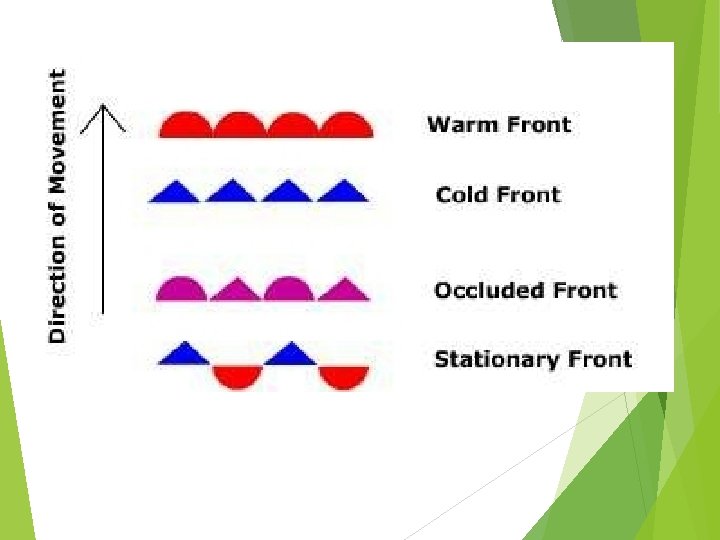
§Fronts üFrontal boundaries are very narrow less than 200 km wide üNormally one air mass is cooler than the other, giving the warmer air a tendency to flow up and over the cooler air mass ü This cooler and denser air acts as a wedge that allows warmer less dense air to rise over it.
üFour Types of Fronts and Dry line
Warm Front 1. warm air moves in and displaces an area of once cooler air. v. Shown on a map as semicircles vclouds become lower as front nears v. Slow rate of advance vlight to moderate precipitation vgradual temperature increase vappearance of cirrus clouds.
Cold Fronts Cold fronts are formed when cooler air replaces an area that was once occupied by warmer air. vshown on map as triangles vcold air replaces warm air vweather is more violent than warm front vfaster rate of advance vprecipitation intense vclear after front passes v Tall, cumulonimbus clouds take shape and may form thunderstorms
Stationary Front vair flow parallel on both sides vdoesn't move vwidespread clouds v. Precipitation light
Occluded fronts This often results from the merging of two cold fronts that overwhelm the warm front. Weather Patterns Associated with an Occluded Front (Ohcluded) vactive cold front overtakes a warm front vweather is complex vprecipitation associated with warm air
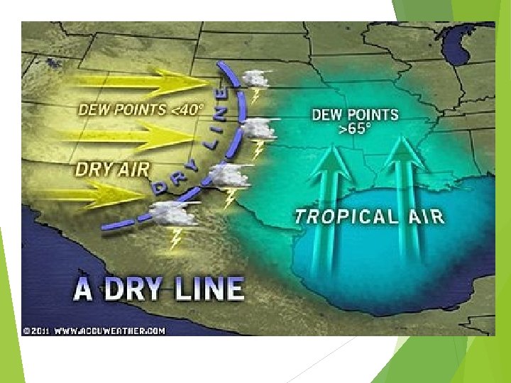
Dry Lines A dry line is a line that separates a moist air mass from a dry air mass. It can also be referred to as a Dew Point Front because the dew point temperature changes drastically across the dry line. The most common place to find a Dry line is just east of the Rocky Mountains separating the Dry air that comes over the mountains from the moist air coming off of the Gulf of Mexico and the Atlantic ocean. Dry lines are extremely rare east of the Mississippi River.
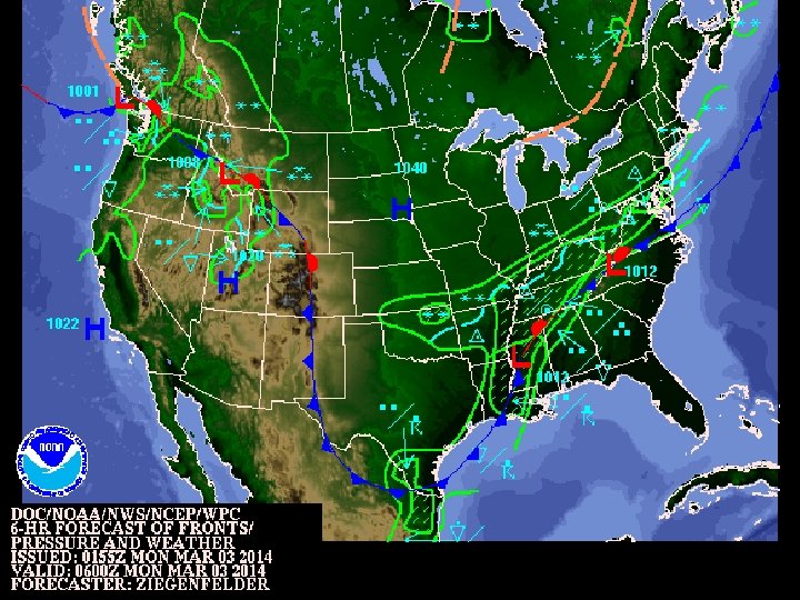
http: //www. hpc. ncep. noaa. gov/basicwx/day 0 -7 loop. html
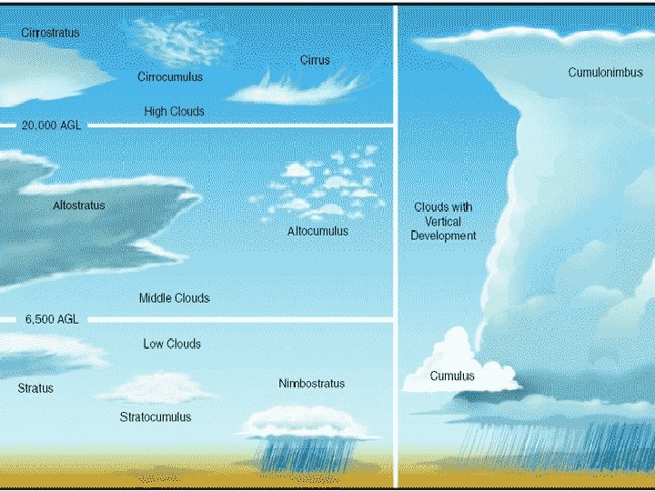
Cloud Classification Clouds are generally classified based on characteristics, such as, altitude, appearance, or origin. Altitude distinctions apply to those clouds that fit in various layers of the atmosphere as follows: high clouds - have bases above 18, 000 feet middle clouds - have bases between 7, 000 and 18, 000 feet low clouds - have bases below 7, 000 feet fog - cloud in contact with the ground multi-level clouds. . . vertically thick spanning multiple layers
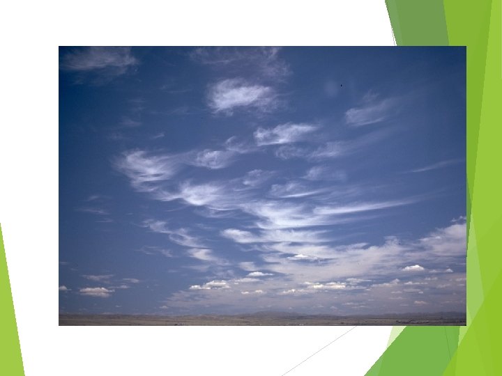
High Clouds are primarily composed of ice crystals and include the following: üCirrus are high altitude wispy clouds. They are usually quite thin and often have a hairlike or filament type of appearance. üCirrocumulus are high clouds that have a distinct patchy and/or wavelike appearance üCirrostratus are high clouds that usually blanket the sky in ill-defined sheets. These clouds are usually optically thin and the sun and moon can usually shine some light through.
§Middle clouds can contain ice crystals and/or water droplets and may occasionally be associated with some light precipitation. üAltocumulus have distinct cloud elements and are either in a patchy, scattered distribution or can appear in linear bands. üAltostratus have a more uniform and diffuse coverage where it is difficult to detect individual elements or features.
§Low clouds are most often composed of water droplets, but can have ice crystals in colder climates. Some of these clouds can develop into the multilevel clouds and can go through various phases üCumulus are usually puffy and often have very distinct edges and usually a noticeable vertical development. They often have a popcorn-like appearance. can be isolated or grouped in clusters üStratocumulus are usually concentrated closer together in clusters or layers and have very little vertical development. üStratus are the lowest of the low clouds. Often appear as an overcast deck, but can be scattered. üFog can be considered as a low stratus cloud in
§Multi-layer clouds are the heavy precipitation producers. üNimbostratus considered multi-layer clouds because their vertical extent often goes well into the middle cloud region. Øare very dark, usually overcast, and are associated with large areas of continuous precipitation. üCumulonimbus, Cumulonimbus can produce lightning, thunder, heavy rains, hail, strong winds, and tornadoes. are the tallest of all clouds that can span all cloud layers and extend above 60, 000 feet. They usually have large anvil-shaped tops which form because of the stronger winds at those higher levels of the
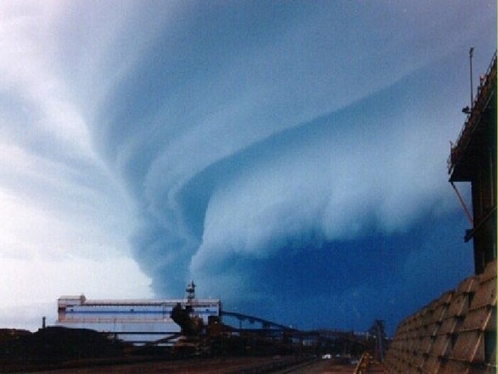
Thunderstorms Most occur in equatorial regions. Most common in the afternoon or evening hours in spring or summer. Three conditions necessary: Water vapor in lower atmosphere Steep vertical temperature gradient Updraft Figure 8. 15
Thunderstorm Development Moist air is forced upwards, cools, and water vapor condenses to form cumulus clouds Cumulus Stage Moisture supply and updrafts continue, clouds grow. A continuous release of latent heat from condensation warms the surrounding air, causing the air to rise further. Expanding the cloud into colder air causes water droplets to freeze. Larger snowflakes fall and melt as raindrops. Large droplets grow until they cannot be supported by updrafts.
Thunderstorm Development, cont. Mature stage Downdrafts and falling precipitation leave the base of the cloud. Updrafts and downdrafts are present. Cloud continues to grow until it reaches the top of unstable atmosphere (tropopause). Storm produces heavy rain, lightning and thunder, and occasionally hail. Dissipative stage Upward supply of moist air is blocked by downdrafts. Thunderstorm weakens, precipitation decreases, and the cloud dissipates. This process may take less than an hour and cause little damage.
Figure 8. 16
Severe Thunderstorms National Winds Weather Service, classified severe if: > 93 km (58 mi) ph, or Hailstones >1. 9 cm (0. 75 in), or Generates a tornado Necessary Wind shear Large High differences in wind speed and direction water vapor content in lower atmosphere Uplift Dry conditions of air mass above a moist air mass
Severe Thunderstorm Types Mesoscale convective systems (MCS) Most common type Very large clusters of self-propagating storms Downdrafts from one creates a new storm Can last for more than 12 hours Squall lines Long lines of individual storm cells Common along cold fronts ahead of the cold air Updrafts form anvil-shaped clouds extending ahead of the line Downdrafts surge forward as gust front in advance of precipitation Can develop along drylines Fronts with differing moisture content
Severe Thunderstorm Types, cont. Supercells Smaller than MCSs and squall lines Extremely violent and spawn most tornadoes Last from 2 -4 hours
Downbursts Derechos Strong, straight-line windstorms Wind gusts can be tornado strength Cause fallen trees, power outages, injuries, fatalities Microbursts Hazard for aviation
Hail Round pieces of ice originating from thunderstorms Contain rings due to adding coatings during updrafts Hail moves up and down in lower part of the storm, adding layers of liquid water, which then freezes. Cause mostly property damage
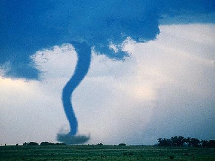
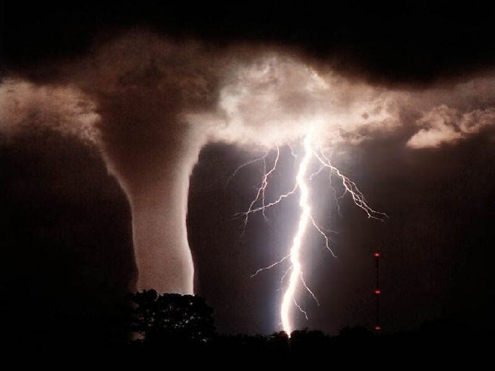
Tornadoes