VECTORIZATION OF GEOLOGIC MAPPING UNITS INCLUDING DESCRIPTIONS USING


 http: //www. esri. com/news/arcnews/fall 02 articles/fall")


, SRID=EPSG: 6566")


 for her suggestions and")

- Slides: 37
VECTORIZATION OF GEOLOGIC MAPPING UNITS INCLUDING DESCRIPTIONS USING EXISTING USGS PUBLISHED 1: 20, 000 MAPS, SCIENTIFIC REPORTS AND THESES INCLUDING A GIS APPLICATION DEMO Iván Santiago GIS Specialist PR Office of Management and Budget October 12, 2018
STRUCTURE WHAT ARE THE NEEDS OF THIS WORK: CONCEPTUALIZATION: SCANNED MAPS TO VECTORIZED VERSIONS, CHOOSING TO REGISTER A SUBSET OF AVAILABLE DATA ON GEOLOGIC QUADRANGLES HOW IT WAS DONE: LINEAGE, PROCESS STEPS: HOW THIS DATASET WAS VECTORIZED? : GEOREFERENCING SCANNED MAPS, MAP COLLECTION, STRUCTURE OF ATTRIBUTE TABLE ISSUES WITH THIS DATASET: MAP DIVERSITY: VARIOUS SOURCES, NON-USGS MAPS, A VOID SPACE: SABANA GRANDE, CHANGES IN GEOLOGIC INTERPRETATIONS OVER TIME: RENAMING GEOLOGIC FORMATIONS, IDENTIFYING GEOLOGIC UNITS ON SUPERPOSED AREAS: WEATHERED MATERIALS, SHEAR ZONES, HYDROTHERMALLY ALTERED ZONES. ADVANTAGES OF VECTORIZATION BY EXAMPLES OF APPLICATIONS PROSPECTIVE SUGGESTED WORK: REVISION OF THE COMPLETE GEOLOGIC 1: 20 K MAP SERIES, INCLUDING THE COMPLETION OF VOID AREAS. DEVISE A DIGITAL MODEL FOR REGISTERING AND STORING GEOLOGIC MAP FEATURES. PR GEOLOGIST LIAISON WITH THE US GEOLOGICAL SURVEY
PURPOSE-NEEDS 1: Scanned geologic maps have great amounts of data and information … but information needs to be ‘extracted’ by a process of conceptualization and sometimes “data reduction”. Then extracted data can be structured and registered into a database using an information system and saved into a database. …This facilitates counting, classifying and analyzing “geologic” data. 2: There was an existing vector geologic map unit version (1993). This work was done by the PR Planning Board. Nevertheless, the work had incomplete names and geologic descriptions, due mainly to software limitations and other reasons.
CONCEPTUALIZATION Example: Geologic Map Mayagüez. Rosario MAP I-1657 Ángel Curet, 1986
MAP INTERPRETATION http: //go. galegroup. com/ps/anonymous? id=GALE%7 CA 135468695&sid=google. Scholar&v=2. 1&it=r&linkaccess=fulltext&issn=00298182&p=AONE&sw=w
GEOLOGIST’S PERSPECTIVE Geologic entities as 3 D blocks, e. g. thickness, unconformities of formations and units
GIS SOFTWARE PERSPECTIVE Traditional GIS perspective… (PLANAR-2 D) http: //www. esri. com/news/arcnews/fall 02 articles/fall 02 gifs/p 1 p 2 -lg. jpg
WHAT DOES THIS GEODATASET CONTAIN? MAP DATA SELECTION Data related to GEOLOGIC MAP UNITS: q USGS quad code (SS, CP, YO…) q unit code (Qa, Krs, TKg, Krs-ls, Krha…) q unit name (San Sebastián Formation, …) q period (old period naming convention) q epoch (Holocene – Pre-Tithonian, …) q description narrative – 4, 000 character spacing “Text” column to hold 99% of geologist’s map unit interpretation.
FEATURES NOT ADDED TO THIS DATASET MAP DATA SELECTION Geologic symbols
STRUCTURE OF THE DATASET q Geometry: q Planar areal “polygons” (2 D), SRID=EPSG: 6566 NAD 83(2011), unit: meter q Esri File Geodatabase 10. x q Validation: Simple Map-Topology (cluster tolerance: 0. 001 to 1 m) q Attribute table fields: q q q Internal ID quad_code …………… unit_name …………… period ………… epoch …………… unit_descript … quad_name …………… shape …………… geol_id ………………… shape_length …… shape_area ………… : : : quadrangle code ……………… : geologic unit code ………… : unit name ………………………………… : ………………… : geometry, polygon, SRID= quad_code & unit_code … : perimeter (m) ………… : area (sqm) ………… : TEXT(2) TEXT(10) TEXT(150) TEXT(50) TEXT(4, 000) TEXT(50) EPSG: 6566 (NAD 83(2011)) TEXT(15) DOUBLE
VECTORIZATION: ADVANTAGES Complete map unit coverage: one geodataset: one attribute table
PROCESS STEPS 1. Obtaining geologic scanned maps: USGS, and a few areas w/o official maps 2. Georeferencing: map using USGS quadrangle index map. Some maps required more control points to match certain existing features (georeferencing: polynomial 2 nd degree and some others using “Adjust” method. 3. Linework: Manual tracing lines along geologic unit boundaries. 4. Converting linework into areal units “polygonization” 5. Attribute data entry, including the whole description available in the scanned map 6. Check for geometric errors: spurious polygons, zero-area polygons, … 7. Data validation: (inspection) and selected editing the geologic map unit names, e. g. San Lorenzo Batholith. This area spreads among various quadrangles with somewhat different names…
WORKING PROCESS: RESULTS Quadrangle: Barranquitas
SOME ISSUES WITH THIS DATASET Quadrangle: Barranquitas Problem: TYPO “rocck”
ISSUES: MAP UNIT BOUNDARIES AND GEO-REFERENCING Quadrangle: Quebradillas Problem: Original scanned geologic quadrangle got corrupted in the database. After that it was substituted by another version with different geo -referencing control points. Discrepancies about 10 meters in some places. CAUTION: This vectorized dataset will spatially align only with its original georeferenced map!!
ISSUES: MODELING HETEROGENEOUS MAP UNITS Quadrangle: Monte Guilarte Issues registering beds or minor sequences of beds in other units; combined lithofacies. Workaround: additional codes attached to unit_codes Kr-ls = Robles Formation; lateritic soils and saprolites Ks-ha = Santa Olaya Lava; hydrothermally altered zone … etc
ISSUES: UNITS HETEROGENEOUS MAP
WORKING PROCESS: RESULTS Quadrangle: Barranquitas
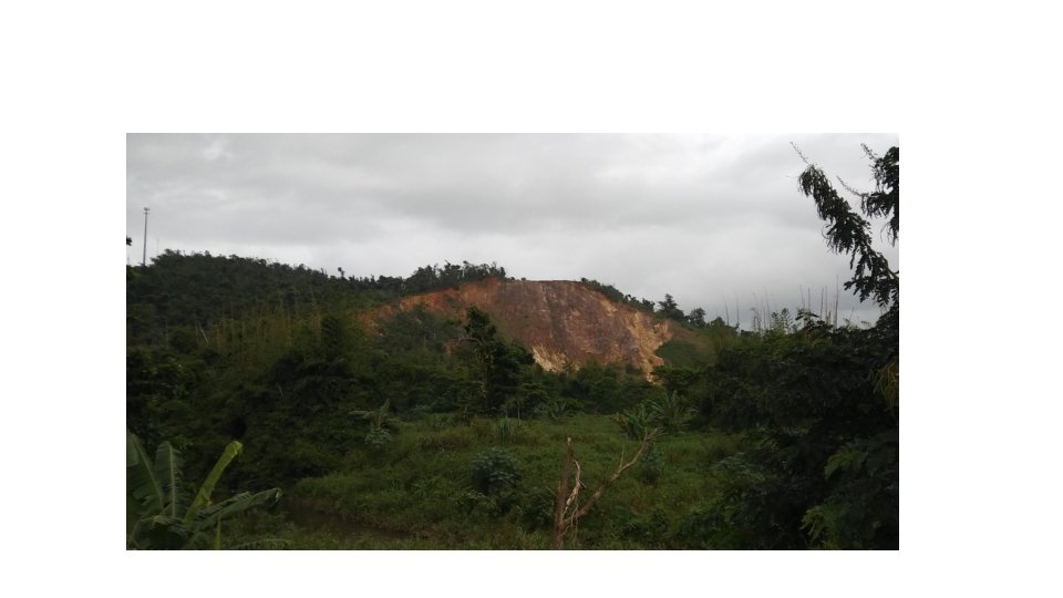
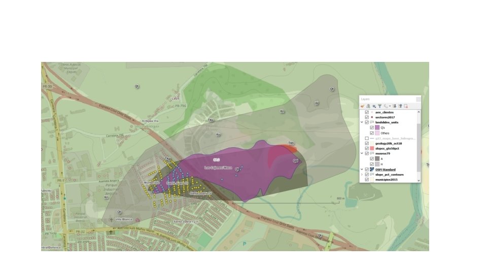
DEMO: BASIC GIS EXERCISE: Identify PREPA clients over landslide-prone geologic units
BASIC GIS EXERCISE: Identify PREPA Clients over landslide-prone geologic units Process: Select geologic units identified as landslides, mudslides, earthflows Ql, Qd, Qm, Qef, etc. Add a subset of geologic units of Cibao and San Sebastián Formations; using Monroe’s map, 1979. Removing some units outside of areas previously identified by Monroe, (Rincón and elsewhere). Derivate percent slope raster and vector geodatasets, and integrating percent slope to geologic units. Select PREPA clients (located as xy points) over previously identified geologic units adding a 100 meter buffer zone. Quantify and classify data points (PREPA clients) using relative location and geologic features.
BASIC GIS EXERCISE: LANDSLIDE PRONE GU’S SELECT --Create spatial TABLE for landslide units DROP TABLE IF EXISTS landslides_units; CREATE TABLE landslides_units (id INTEGER PRIMARY KEY AUTOINCREMENT, quad_code text, unit_name text, unit_descript text, pctslope_min double, pctslope_max double, pctslope_mean double); SELECT Add. Geometry. Column('landslides_units', 'geom', 6566, 'MULTIPOLYGON', 'XY'); SELECT Create. Spatial. Index('geom', 'Geometry'); INSERT INTO landslides_units (id, quad_code, unit_name, unit_descript, pctslope_min, pctslope_max, pctslope_mean, geom) SELECT g. rowid , quad_code , unit_name , unit_descript , pctslope_min , pctslope_max , pctslope_mean , g. geom as geom from geology 20 k_oct 18 g where unit_code IN ('Ql', 'Qls', 'Qef', 'Qda') OR geol_id IN ('JU-Qd', 'BR-Qd', 'CL-Qc', 'CY-Qc', 'DE-Qc', 'PO-Qm', 'QU-Qm') OR unit_code LIKE '%-ls%' OR unit_name LIKE '%San Sebas%' OR unit_name LIKE '%Cibao%' OR geol_id = 'CY-TKhv' OR (unit_code LIKE 'Q%' and pctslope_mean >=50) and g. rowid in ( select rowid from spatialindex where f_table_name = 'geology 20 k_oct 18' and search_frame = g. geom) order by unit_code; * Note: some other areas In other words… A multi-criteria selection were removed and others added “manual
BASIC GIS EXERCISE: Monroe, 1979, Landslide susceptibility areas: Highest and high
EXAMPLE: SPATIAL QUERIES Which and how many PREPA clients are over geologic units classified as highly susceptible for landslides? --CREATE BUFFER @100 m based on landslide_units and Select PREPA clients intersecting. . . DROP TABLE IF EXISTS aee_clientes_buff 100 m; CREATE TABLE aee_clientes_buff 100 m (pk_uid integer primary key, account_nu text); SELECT Add. Geometry. Column('aee_clientes_buff 100 m', 'geom', 6566, 'POINT', 'XY'); SELECT Create. Spatial. Index('geom', 'Geometry'); INSERT INTO aee_clientes_buff 100 m (account_nu, geom) SELECT account_nu In other words… , st_intersection(aee. shape, ls. geom) A Spatial Join from aee_clientes aee, landslides_units_buff 100 m ls Where st_covers(ls. geom, aee. shape) and aee. rowid IN ( SELECT rowid FROM spatialindex WHERE f_table_name = 'aee_clientes' AND search_frame = ls. geom);
EXAMPLE: SPATIAL QUERIES Which and how many PREPA clients are over geologic units classified as highly susceptible for landslides? --Attach geologic data 1: 20 K: use last version oct_2018. DROP TABLE IF EXISTS aee_clientes_buff 100 m_geology; CREATE TABLE aee_clientes_buff 100 m_geology (pk_uid integer primary key, account_nu text, quad_code text, unit_name text, unit_descript text); SELECT Add. Geometry. Column('aee_clientes_buff 100 m_geology', 'geom', 6566, 'POINT', 'XY'); SELECT Create. Spatial. Index('geom', 'Geometry'); INSERT INTO aee_clientes_buff 100 m_geology (account_nu, quad_code, unit_name, unit_descript, geom) SELECT account_nu , quad_code , unit_name , unit_descript , st_intersection(aee. geom, g. geom) from aee_clientes_buff 100 m aee, geology 20 k_oct 18 g Where st_intersects(g. geom, aee. geom) and aee. rowid IN ( SELECT rowid FROM spatialindex WHERE f_table_name = 'aee_clientes_buff 100 m' AND search_frame = g. geom); In other words… Another Spatial Join
VECTORIZATION: ADVANTAGES: COUNT OF PREPA CLIENTS OVER LANDSLIDE PRONE GEOLOGIC UNITS PREPA clients at or near up to 100 meters of landslide-prone geologic units
VECTORIZATION: ADVANTAGES: COUNT OF PREPA CLIENTS OVER LANDSLIDE PRONE GEOLOGIC UNITS PREPA clients at or near up to 100 meters of landslide-prone geologic units
VECTORIZATION: ADVANTAGES: COUNTING, PREPA clients over or CLASSIFYING near up to 100 meters of landslide-prone geologic units
VECTORIZATION: ADVANTAGES: COUNTING, CLASSIFYING Location: Moca, PR
VECTORIZATION: ADVANTAGES: COUNTING, CLASSIFYING
VECTORIZATION: ADVANTAGES: COUNTING, CLASSIFYING PREPA clients at or near up to 100 meters of landslide-prone geologic units
VECTORIZATION: ADVANTAGES: COUNTING, CLASSIFYING
FINAL CONSIDERATIONS This is an exercise or DEMO. Our intention is to show our “limited” version of selected geologic data can help us to determine areas with geologic risks. …Nevertheless, GIS tools help by integrating other disparate and/or related data such as slopes to this DEMO analysis. As a DEMO, therefore our numbers are subject to revision. Reasons being: Geologists selecting relevant data by a thorough understanding of geologic features. GIS, Excel, Pivot. Tables, Graphs are just tools. Old PREPA data (2009). Since then, there are newer urbanized areas, especially over Toa Alta. Some areas identified by Monroe, 1979 as high susceptibility areas (H), could not be identified on the geologic maps (El Yunque, Caguas) Some other (H) areas lied at shallow slopes; they were not considered in this DEMO, especially at Bayamón, and at San Juan Metro area. Is up to geologists and environmental scientists to do a more “rigorous” analysis
PROSPECTIVE SUGGESTED WORK v REVISION OF THE COMPLETE GEOLOGIC 1: 20 K MAP SERIES, INCLUDING THE COMPLETION OF VOID AREAS. v A NEW DIGITAL MODEL FOR REGISTERING AND STORING GEOLOGIC MAP FEATURES: geologic units, faults, minerals, and other geologic features v PR “STATE” GEOLOGIST LIAISON WITH US GEOLOGICAL SURVEY. This means $$$ that can be used to improve geologic data, and planning tools.
SOURCES 1. Special thanks to Darysabel Pérez-Martínez (geologist at PRHTA-DTPW) for her suggestions and willingness to ask our questions regarding geologic features. Errors in this work are my responsibility. 2. Geologic maps available, 1: 20 K USGS, master theses (Guánica: UPRM, Culebra: Rice. U@Texas), unofficial but complete map (Rincón), published studies and inventories such as Vieques and Desecheo Islands. Sabana Grande Quad has no 1: 20 K published USGS map!! 1: 100 K map version used in place. 3. Monroe, W. , 1979 Map showing landslides and areas of susceptibility to landsliding in Puerto Rico MAP I-1148. Available PDF map at: https: //pr. water. usgs. gov/public/online_pubs/mism_i_1148/index. html 4. First version of vectorized geologic units map done by PR Planning Board (1993) 5. Digital elevation models (deriving slopes) CRIM Basemap project, 1996 -98. -- -------- DOWNLOAD PUBLIC DIGITAL DATA ------------------- Current digital geologic units vector map available at: http: //gis. pr. gov/descarga. Geodatos/ambientales/Pages/Geologia. aspx Georeferenced geologic scanned maps available at: http//gis. pr. gov/downloads/geology
FIN