Update on SPo RT Shortterm Forecasting Activities WRF

- Slides: 18
Update on SPo. RT Short-term Forecasting Activities WRF Microphysical Adjustments Land Information System High-res SST Forecast Impacts Lightning Warning / Nowcasting WRF Lightning Forecasts Contributions to WRF EMS AIRS Assimilation Scatterometer Assimilation (Lapenta visit, 24 March 2010) transitioning unique NASA data and research technologies to operations
Land Surface Modeling with LIS • Precip Verification Study over SE U. S. – LIS land surface initialization vs. interpolated NAM – Application of non-standard verification methods • Real-time LIS/Noah at SPo. RT – Output to initialize WRF EMS runs – Diagnostics for NWS BHM CI study • Incorporate MODIS veg composites into LIS (underway) transitioning unique NASA data and research technologies to operations
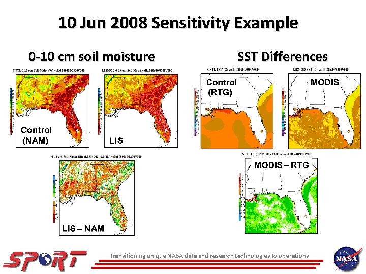
10 Jun 2008 Sensitivity Example 0 -10 cm soil moisture SST Differences transitioning unique NASA data and research technologies to operations
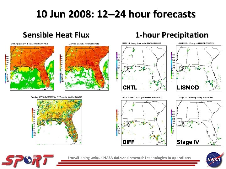
10 Jun 2008: 12 24 hour forecasts Sensible Heat Flux 1 -hour Precipitation CNTL LISMOD DIFF Stage IV transitioning unique NASA data and research technologies to operations
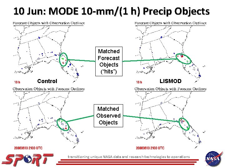
10 Jun: MODE 10 -mm/(1 h) Precip Objects Matched Forecast Objects (“hits”) Control LISMOD Matched Observed Objects transitioning unique NASA data and research technologies to operations
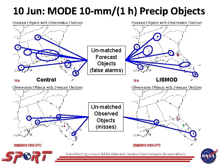
10 Jun: MODE 10 -mm/(1 h) Precip Objects Un-matched Forecast Objects (false alarms) Control LISMOD Un-matched Observed Objects (misses) transitioning unique NASA data and research technologies to operations
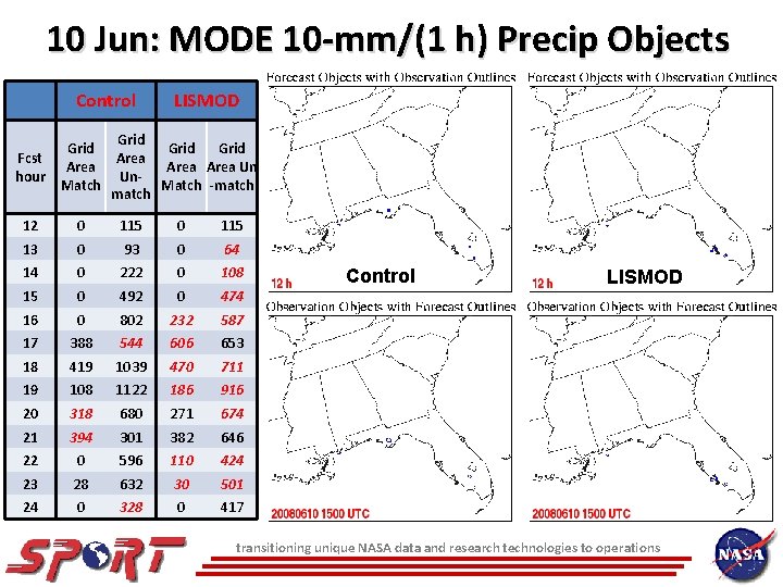
10 Jun: MODE 10 -mm/(1 h) Precip Objects Control Grid Fcst Area hour Match LISMOD Grid Area Un Un. Match -match 12 0 115 13 0 93 0 64 14 0 222 0 108 15 0 492 0 474 16 0 802 232 587 17 388 544 606 653 18 419 1039 470 711 19 108 1122 186 916 20 318 680 271 674 21 394 301 382 646 22 0 596 110 424 23 28 632 30 501 24 0 328 0 417 Control LISMOD transitioning unique NASA data and research technologies to operations
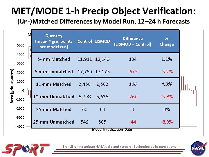
MET/MODE 1 -h Precip Object Verification: (Un-)Matched Differences by Model Run, 12 24 h Forecasts Quantity (mean # grid points per model run) Control LISMOD Difference (LISMOD – Control) # Forecasts Quantity Improved 134 Degraded 5 -mm Matched 11, 911 12, 045 5 -mm matched 39 41 5 -mm Unmatched 17, 750 17, 175 -575 5 -mm unmatched 56 25 10 -mm matched 10 -mm Matched 2, 456 2, 562 37 10 -mm unmatched 48 10 -mm Unmatched 6, 798 6, 538 25 -mm matched 13 25 -mm unmatched 25 -mm Matched 60 25 -mm Unmatched 549 60 46 505 106 39 33 -260 8 0 32 -44 % Change 1. 1% -3. 2% 4. 3% -3. 8% 0% -8. 0% transitioning unique NASA data and research technologies to operations
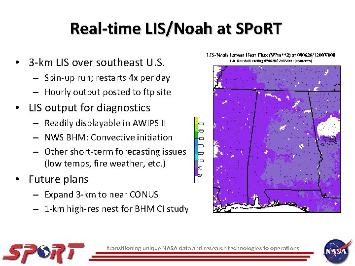
Real-time LIS/Noah at SPo. RT • 3 -km LIS over southeast U. S. – Spin-up run; restarts 4 x per day – Hourly output posted to ftp site • LIS output for diagnostics – Readily displayable in AWIPS II – NWS BHM: Convective initiation – Other short-term forecasting issues (low temps, fire weather, etc. ) • Future plans – Expand 3 -km to near CONUS – 1 -km high-res nest for BHM CI study transitioning unique NASA data and research technologies to operations
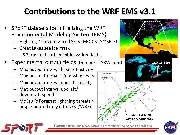
Contributions to the WRF EMS v 3. 1 • SPo. RT datasets for initializing the WRF Environmental Modeling System (EMS) – High-res, 1 -km enhanced SSTs (MODIS+AMSR-E) – Great Lakes sea ice mask – LIS 3 -km land surface initialization fields • Experimental output fields (Dembek – ARW core) – Max output interval base reflectivity – Max output interval 10 -m wind speed – Max output interval updraft helicity – Max output interval updraft/ downdraft speed – Mc. Caul’s Forecast lightning threats* (implemented only into NSSL/WRF) NOAA/GLERL Ice Mask Super Tuesday Tornado outbreak transitioning unique NASA data and research technologies to operations
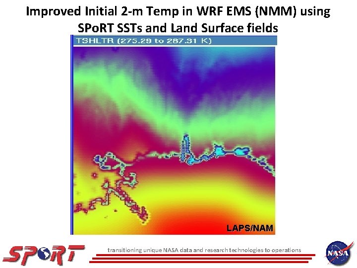
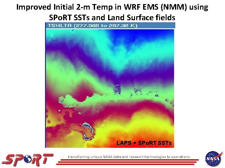
Improved Initial 2 -m Temp in WRF EMS (NMM) using SPo. RT SSTs and Land Surface fields LAPS/NAM transitioning unique NASA data and research technologies to operations
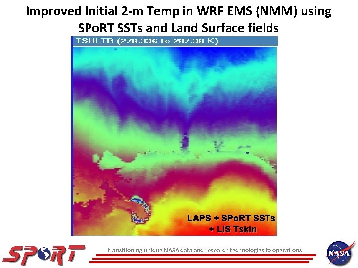
Improved Initial 2 -m Temp in WRF EMS (NMM) using SPo. RT SSTs and Land Surface fields LAPS + SPo. RT SSTs transitioning unique NASA data and research technologies to operations
Improved Initial 2 -m Temp in WRF EMS (NMM) using SPo. RT SSTs and Land Surface fields LAPS + SPo. RT SSTs + LIS Tskin transitioning unique NASA data and research technologies to operations
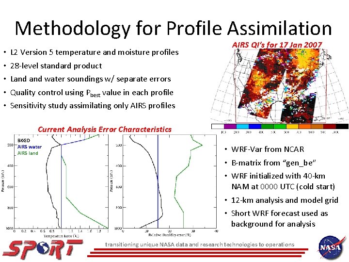
Methodology for Profile Assimilation • • • L 2 Version 5 temperature and moisture profiles AIRS QI’s for 17 Jan 2007 28 -level standard product Land water soundings w/ separate errors Quality control using Pbest value in each profile Sensitivity study assimilating only AIRS profiles Current Analysis Error Characteristics BKGD AIRS water AIRS land • WRF-Var from NCAR • B-matrix from “gen_be” • WRF initialized with 40 -km NAM at 0000 UTC (cold start) • 12 -km analysis and model grid • Short WRF forecast used as background for analysis transitioning unique NASA data and research technologies to operations
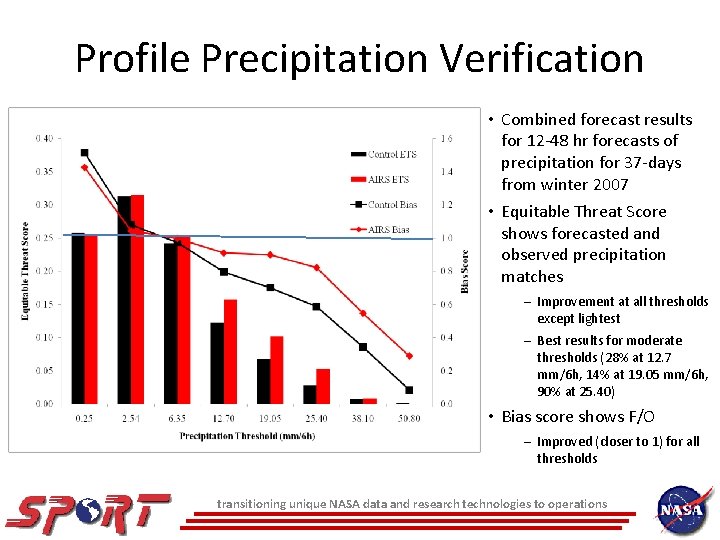
Profile Precipitation Verification • Combined forecast results for 12 -48 hr forecasts of precipitation for 37 -days from winter 2007 • Equitable Threat Score shows forecasted and observed precipitation matches – Improvement at all thresholds except lightest – Best results for moderate thresholds (28% at 12. 7 mm/6 h, 14% at 19. 05 mm/6 h, 90% at 25. 40) • Bias score shows F/O – Improved (closer to 1) for all thresholds transitioning unique NASA data and research technologies to operations
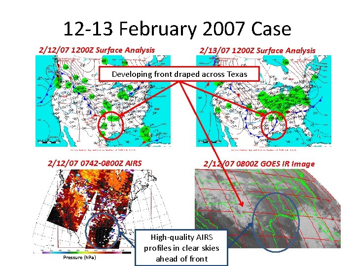
12 -13 February 2007 Case 2/12/07 1200 Z Surface Analysis 2/13/07 1200 Z Surface Analysis Developing front draped across Texas 2/12/07 0742 -0800 Z AIRS Pressure (h. Pa) 2/12/07 0800 Z GOES IR Image High-quality AIRS profiles in clear skies ahead of front
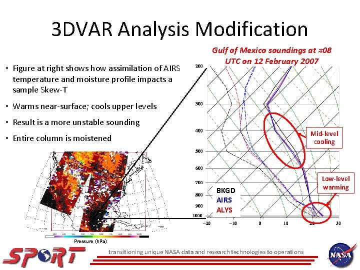
3 DVAR Analysis Modification • Figure at right shows how assimilation of AIRS temperature and moisture profile impacts a sample Skew-T Gulf of Mexico soundings at ≈08 UTC on 12 February 2007 • Warms near-surface; cools upper levels • Result is a more unstable sounding Mid-level cooling • Entire column is moistened BKGD AIRS ALYS Pressure (h. Pa) transitioning unique NASA data and research technologies to operations Low-level warming
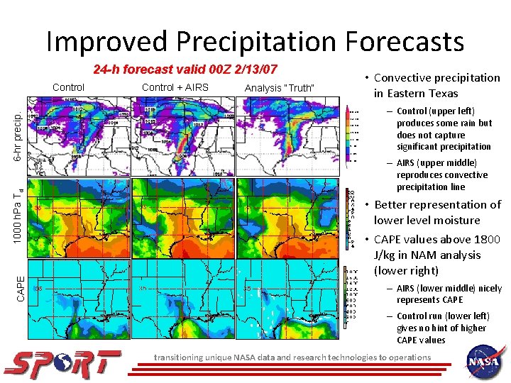
Improved Precipitation Forecasts 24 -h forecast valid 00 Z 2/13/07 CAPE 1000 h. Pa Td 6 -hr precip. Control + AIRS • Convective precipitation in Eastern Texas Analysis “Truth” 50. 80 38. 10 25. 40 19. 05 12. 70 6. 35 2. 54 0. 25 – Control (upper left) produces some rain but does not capture significant precipitation – AIRS (upper middle) reproduces convective precipitation line • Better representation of lower level moisture • CAPE values above 1800 J/kg in NAM analysis (lower right) – AIRS (lower middle) nicely represents CAPE – Control run (lower left) gives no hint of higher CAPE values transitioning unique NASA data and research technologies to operations