Plate Tectonics Review Recall Continental Drift vs Plate


 in rock along which movement has occurred. Movement along fault produces")


 Waves-also called Body Waves ü Compressional motion (slinky)=back and forth ü")
 Waves-also called Shear, or Transverse waves ü Shear motion perpendicular")


 Richter Scale-measures INTENSITY of ground movements. Max amplitude of")
 Mercalli Intensity Scaleü ü Measures quake effects")
 Moment Magnitude • Used for LARGEST events •")


 quakes")


- Slides: 42
Plate Tectonics Review Recall~ • Continental Drift vs. Plate Tectonics • Oceanic Crust vs. Continental Crust • Lithosphere and Asthenosphere • Are the plates moving in the same direction? How do you know? • What is the driving force of plate movement?
Plate Tectonics Review 3 Types of plate boundaries: • Divergent • Convergent • Transform (strike-slip)
Distinguishing Plate Boundaries • EQ’s not randomly distributed! • Most occur at plate boundaries (faults) • Low to high magnitude at transform, 0 -C and O-O subduction zones, and at C-C collisional zones. • Low to medium magnitude at divergent zones.
How do Earthquakes Occur? Earthquake-shaking of the earth’s crust by a release of energy Major Cause=Elastic Rebound • Stress buildup between lithospheric plates • Stresses cause plates to deform • Stresses overcome friction • Plates suddenly move • Energy is released as an earthquake
Depth of Quakes • Depth is dependent upon plate boundary involved Divergent and transform < 30 km Convergent (subduction) up to 700 km • Focus~ point WITHIN the Earth where first movement occurs • Epicenter~ point on Earth’s SURFACE DIRECTLY above the focus
Earthquake Focus & Epicenter
Faults Break (fracture) in rock along which movement has occurred. Movement along fault produces quakes and resulting waves.
Types of Faults 3 Main Types~ In a strike-slip fault, the movement of blocks along a fault is horizontal. In a normal fault, the block above the fault moves down relative to the block below the fault. Dipslip/normal In a reverse fault, the block above the fault moves up relative to the block below the fault.
Earthquake Waves • Earthquakes create waves that shake the ground as they pass. ***Consider what happens when a drop of rain hits a pond of water. The drop disturbs the flat surface of the water and creates waves that travel outward in all directions from the disturbance. These waves travel on the surface of the pond, along the interface between the water and the air.
P-Waves Primary (P) Waves-also called Body Waves ü Compressional motion (slinky)=back and forth ü Travel faster than S-waves ü Can move through fluid -move through the outer core!
S Waves Secondary (S) Waves-also called Shear, or Transverse waves ü Shear motion perpendicular to direction the wave is traveling (rope)=side to side ü Cannot move directly through fluid –bounce off outer core!
Surface Waves~ also called Love/Raleigh Waves • Travel only along surface • Slowest, but most damaging! • Form when P and S waves reach surface Love=horizontal; Rayleigh=up and down http: //www. exo. net/~pauld/summer_institute/summer_day 10 waves/wavety pes. html
P & S-Wave Movement • Savage Earth Animation: Earthquake!
Locatin’ the Shakin’ • Seismograph “feels” the quake • Seismologists measure time BETWEEN P-waves and Swaves on a seismogram--called LAG TIME • Takes 3 seismographs to locate quake WHY? ? ? • 1 tells how far from THAT seismograph-distance but NOT ______! • 3 or more can draw circles that meet---called TRIANGULATION
The Seismogram “A Shaking Record” • P-waves faster, first to reach seismograph • S-waves follow • Surface waves last
Time-Travel Graph • Used to show relationship between P and S wave travel times and distance to epicenter http: //geoweb. tamu. edu/courses/geol 101/heaney 02/Chapter 16/sld 021. htm
The Modern Seismograph • Detects seismic waves digitally • Called broadbandcan sense ground motion over wide range of frequencies
P and S Waves show Earth’s Interior Layers! • P & S wave velocity increases when travelling through more dense materials • S-waves cannot travel through liquids
Shadow Zone Defined- An area of the Earth that does not receive direct P-waves • S-waves stopped by liquid outer core • P-wave velocity decreases, waves are bent • Can calculate radius of liquid outer core! http: //earthquake. usgs. gov/learn/glossary/? term. ID=170&alpha=S
Shadow Zone
The Moho • Abrupt change in the velocities of P and S waves at boundary of crust and mantle (different rock compositions). • Boundary where dense rock of mantle meets less dense rock of crust, • 32 km under continents; 5 -10 km under oceans.
The Transition Zone • Middle of mantle-separates upper from DENSER lower. • Different densities because lower mantle under more pressure • Abrupt changes in P and S wave velocities when they pass between rock of SAME composition, but DIFFERENT densities.
Earthquake Measurement 3 Ways: 1) Richter Scale-measures INTENSITY of ground movements. Max amplitude of S-wave from seismogram. Each increase of one whole number represents a 10 -fold increase in wave amplitude. Ex: An earthquake that measures 5. 0 on the Richter scale has a shaking amplitude 10 times larger than one that measures 4. 0, and corresponds to an energy release of √ 1000 ≈ 31. 6 times greater.
Earthquake Measurement Do You Feel It? 2) Mercalli Intensity Scaleü ü Measures quake effects at a particular location Varies between locations-WHY? An opinionated measure of size Roman numerals: I=not felt XII=buildings nearly destroyed
Earthquake Measurement~ The BIG STUFF! 3) Moment Magnitude • Used for LARGEST events • Directly related to movements along rupture area, or fault plane---indicates TOTAL ENERGY involved Ex: 1906 San Francisco=Richter 8. 3 1964 Alaska=Richter 8. 5 Alaska EQ released 2 X energy!
movie
Tsunami Facts • From Japanese “tsu”=harbor, and “nami”=wave • Caused by displacement of water (quakes, submarine landslides) • Travel VERY quickly-can cross oceans within HOURS!!! • NOT single waves-”wave trains” =multiple waves • Smaller wave heights (amplitudes) offshore, can pass by unnoticed by fishermen on open water • Wave height increases close to shore, causing devastation
Formation of a Tsunami Subduction zones are potential tsunami locations • Energy accumulates • similar to energy in a compressed spring • can accumulate for yearseven centuries!
Formation of a Tsunami • Energy exceeds frictionoverriding plate snaps back • Shoves overlying water, overriding plate lowered • A tsunami is born • Moving wave travels out from where the earthquake has occurred. • Some water travels out and across the ocean basin, and, some water rushes landward to flood the recently lowered shoreline.
Tsunami Warning Procedures Tsunami Warning Center
Signs of an Approaching Tsunami • An earthquake may be felt. • Large quantities of gas may bubble to the water surface and make the sea look as if it is boiling. • The water in the waves may be unusually hot. • The water may smell of rotten eggs (hydrogen sulfide) or of petrol or oil. • The water may sting the skin. • A thunderous boom may be heard followed by – a roaring noise as of a jet plane – or a noise akin to the periodic whop-whop of a helicopter, – or a whistling sound. • The sea may recede to a considerable distance. • A flash of red light might be seen near the horizon.
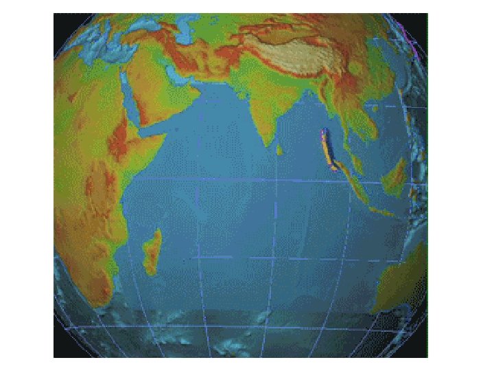
December 2004 Tsunami • Underwater earthquake off coast of Sumatra • Slip on the fault where the oceanic portion of the Indian Plate slid under Sumatra, part of the Eurasian Plate • <9. 0 on Richter Scale • Affected numerous countries within hours, the first few without warning • Killed more than 300, 000 people-natives and tourists Countries most affected by the 2004 Indian Ocean earthquake.
2004 Tsunami, Thailand Maximum recession of tsunami waters at Kata Noi Beach, Thailand, before third, and strongest, tsunami wave (sea visible in the right corner, the beach is at the extreme left), 10: 25 a. m. local time.
2004 Tsunamis Second tsunami wave starting to retreat, Kata Noi Beach, Thailand, 10: 17 a. m. Receding waters after the second tsunami, 10: 20 a. m
2004 Tsunamis 3 rd tsunami wave, 11: 00 a. m. 4 th tsunami wave, 11: 22 a. m.
Sumatra Tsunami
2004 Tsunami Devastation
Plate Tectonics-the cause of quakes! In the U. S. , MOST (not all) quakes occur in California, Wasthingon State, and Alaska. What type of plate boundaries are involved? ? ?
Earthquake Damage 1906 San Francisco Quake Photo courtesy USGS A section of Interstate 880 in Oakland, California, damaged by the magnitude 7. 1 earthquake that shook the San Francisco area in 1989.
Skyscrapers in an Earthquake • In this earthquake simulation, the building on the right has a standard foundation; the building on the left has base isolators installed in its foundation. As the ground moves back and forth, the base isolators distort and absorb the motion, significantly decreasing the motion of the building.