CONTINENTAL DRIFT AND PLATE TECTONICS HISTORY OF CONTINENTAL


 of rocks on different")

 existed about 250 million years ago and began")


 • If the plates are ocean-continental:")


- Slides: 48
CONTINENTAL DRIFT AND PLATE TECTONICS
HISTORY OF CONTINENTAL DRIFT • In German "die Verschiebung der Kontinente" • As long as 400 years ago, map makers noted that the continents’ shapes looked to fit together like a puzzle. • LOOK! • Cartographer Abraham Ortelius in his work Thesaurus Geographicus. . . suggested that the Americas were "torn away from Europe and Africa. . . by earthquakes and floods"
THE COMPLETED PUZZLE
THEORY OF CONTINENTAL DRIFT • 1912: Alfred Wegener proposed that continents move! • Reaction by the scientific community • HAHAHA. ROFL - ARE YOU KIDDING?
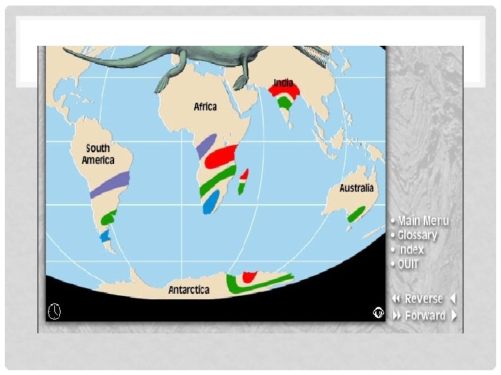
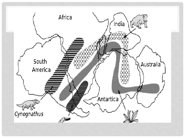
WHY DID WEGENER THEORIZE CONTINENTAL DRIFT? #1 Shape of the continents #2 Fossil clues: • Wegener found similar fossils on different continents • The fossils that he found could probably not have spread between continents • Freshwater reptile fossil • Plant fossil • Similarly evolved species • Why are these two significant? Would finding a bird on two continents support continental drift as well?
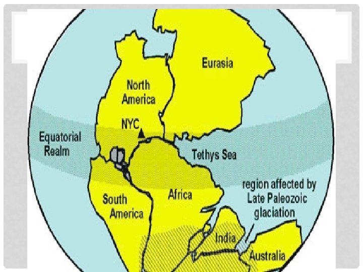
• #3 Climate clues • Wegener found warm climate fossils in the Arctic and cold climate fossils near the equator. • Warm weather fossils • Evidence of glaciers
• #4 Rock clues Wegener found similar strata (layers) of rocks on different continents. • Could this be a coincidence?
MATCHING ROCK LAYERS
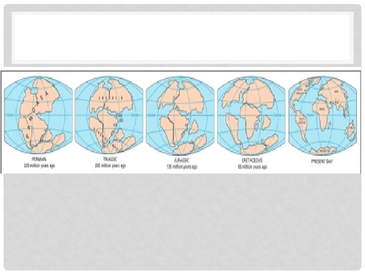
• Pangaea – (“all land”) existed about 250 million years ago and began separating around 200 million years ago. • Problem - Wegener’s theory proposed only that the continents were once one supercontinent and they had “moved” apart but could not explain HOW.
• Things Wegener didn’t know: • What the inside of the Earth looked like • That the Earth was broken into plates • That the location of earthquakes and volcanoes shows plate boundaries • Convection Currents • Was his theory accepted by other scientists? • His theory did not become accepted until the 1950’s/1960’s. Why? • Wegener was appreciated posthumously
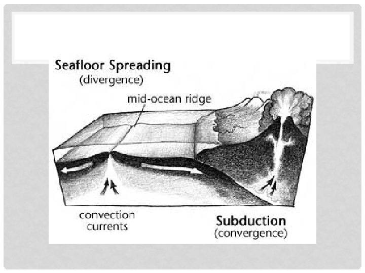
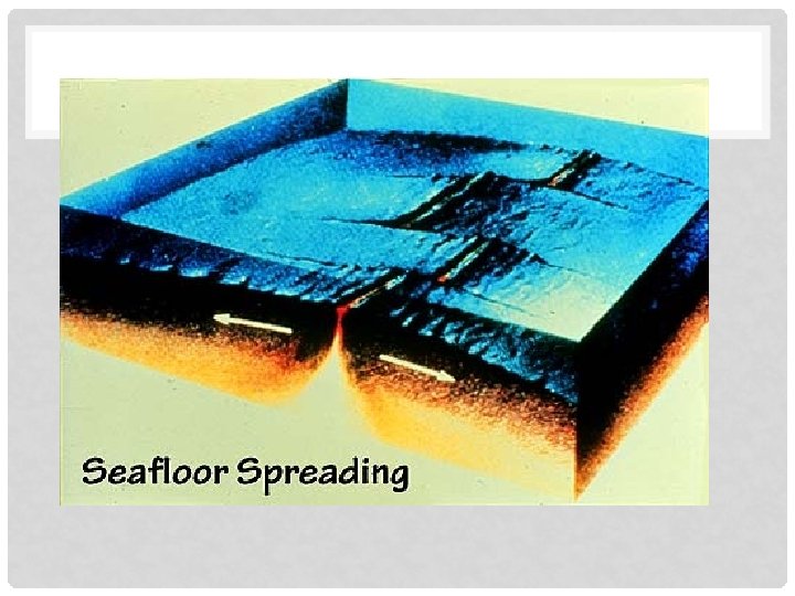
• 1960’s: Harry Hess given credit for providing some of the proof necessary to support Wegener’s theory • Hess’s theory of seafloor spreading • Believed that material moved up at midocean ridges and pushed material outward
MID-OCEAN RIDGES DISCOVERED IN 1950’S
• Why Did Hess believe that the seafloor was spreading? • The discovery of the midocean ridges • Core samples of ocean floor showed that the age of rocks INCREASED the farther they were from midocean ridges • Core samples also showed corresponding magnetic reversals on each side of the mid-ocean ridge
ROCK AGES
MAGNETIC REVERSALS
SO WHERE ARE WE AT THIS POINT? • We believe the continents have moved. • These findings provided proof for Hess’s theory and further supported Wegener’s theory • Theory of Plate Tectonics has still not been developed. • But no one still understands why or how the plates move. We are still lacking the MECHANISM.
3 • 1960’s Wilson and other scientists gave mechanism to explain HOW the plates are moved. • Scientists proposed that the Earth’s lithosphere is broken into plates, and that CONVECTION CURRENTS in the plastic asthenosphere moved the lithospheric plates above. • All of this information, plus LOTS more, developed into our current theory of Plate Tectonics.
MAPPING VOLCANOES
MAPPING EARTHQUAKES
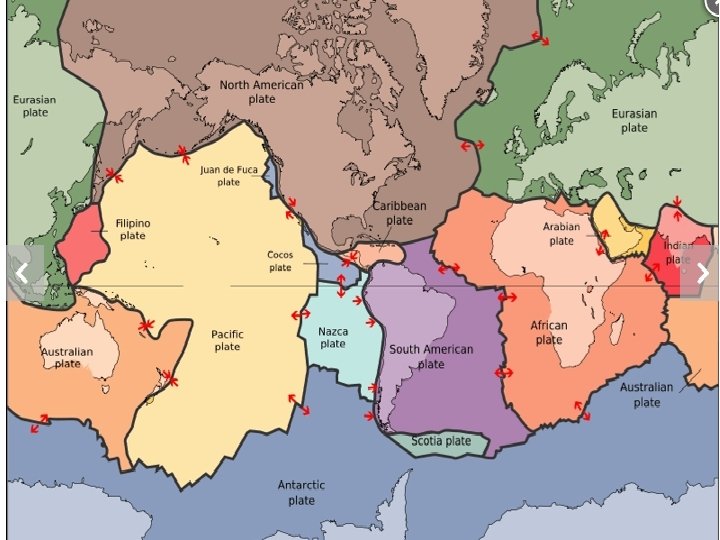
PLATE BOUNDARIES: • This is where two or more lithospheric plates meet • Called faults or boundaries • Lots of tectonic activity (i. e. volcanoes and earthquakes) occurs at these places • Three types:
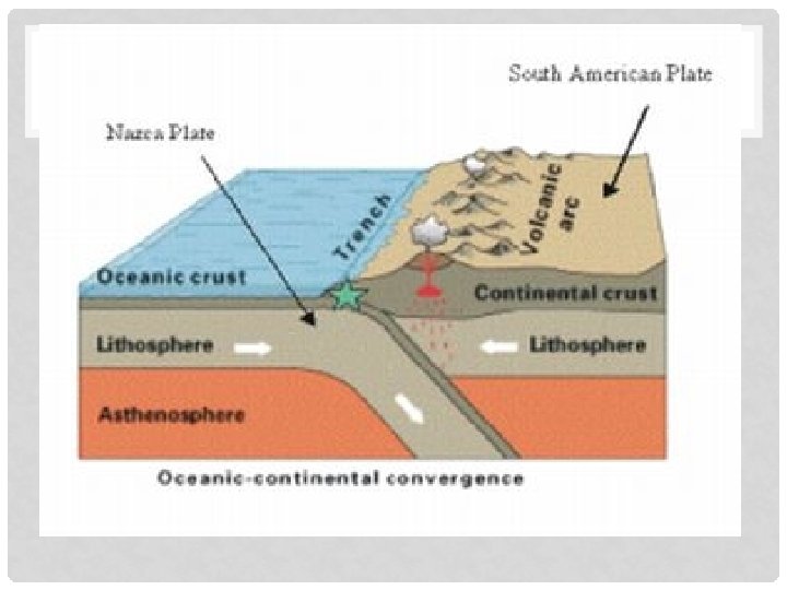
CONVERGENT BOUNDARIES • Two plates colliding (moving together) • If the plates are ocean-continental: Subduction zones, mountains, volcanoes and ocean trenches will form • Oceanic crust is destroyed here • More dense (basalt vs. granite) • Examples are Ring of Fire and Andes Mts • If the plates are both continental • No subduction, only mountain building • Himalayas are example • Crust is neither created nor destroyed
“RING OF FIRE”
ANDES MOUNTAINS
HIMALAYAN MOUNTAINS
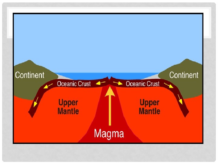
DIVERGENT BOUNDARIES TWO PLATES MOVING APART • If the plate is an ocean plate: • Forms mid-ocean ridge • Mid-Atlantic Ridge is example • If the plate is continental: • Forms rift valleys • Great Rift Valley is example • New rock is created here
MID-ATLANTIC RIDGE
GREAT RIFT VALLEY
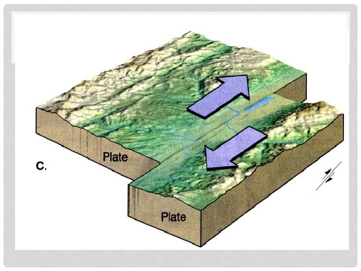
TRANSFORM BOUNDARIES A. K. A. STRIKE-SLIP BOUNDARIES • • Two plates sliding/scraping past each other Earthquakes are common Crust is neither created nor destroyed San Andreas Fault and Haiti our examples
SAN ANDREAS FAULT DOES NOT INVOLVE THE JUAN DE FUCA PLATE
HAITI 2010
• Where would each form? • Volcano • Seafloor Spreading • Mountains • Subduction Zone • Rift Valley • Name two places where each type of boundary would form using your text.
PLATE TECTONICS – LATE 1960’S POST HARRY HESS’ SEAFLOOR SPREADING • Plate tectonics (from the Latin tectonicus, from "pertaining to building”) is a scientific theory that describes the large-scale motion of Earth's lithosphere on a molten asthenosphere, due to convection currents caused by the transfer of heat from the Earth’s core. • Plate motions range up to a typical 10– 40 mm/year (Mid-Atlantic Ridge; about as fast as fingernails grow), to about 160 mm/year (Nazca Plate; about as fast as hair grows).
WHY DO THE PLATES MOVE? • Solid lithospheric plates move because the plastic asthenosphere is moving. • Radioactive reactions in the core heat magma deep in the Earth which becomes less dense and rises. • As magma cools it becomes more dense, sinks, then reheats, forming CONVECTION CURRENTS (50 million years, though deeper convection can be closer to 200 million years).
MEASURING PLATE MOVEMENT • Scientists NOW use lasers, GPS and satellites to measure plate movement over time.
HOW FAR WOULD YOU HAVE TO DRILL THROUGH THE LITHOSPHERE TO GET TO THE ASTHENOSPHERE? 7 – 70 KM (4 – 45 MILES)