Plate Tectonics Continental Drift n Theory that the


 2.")

 Example : Peru – Chile Trench –")
 n n n 1. ocean plate is")

 Example: Aleutian Islands, Islands of Japan")
 1. 2. 3. 4. Subduction")

 n 1. Major mountain building due to")


")


- Slides: 49
Plate Tectonics
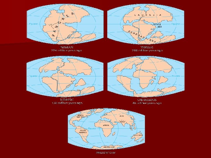
Continental Drift n Theory that the continents were once all one large super continent and have since drifted apart. n Pangea n Proposed by Alfred Wegner in 1912
Pangea
Evidence for Continental drift Shape of continents look like they fit together 2. Mineral and rock formations on each continent. 3. Fossil evidence 4. Mountain ranges 5. Past climates *This theory gives no explanation for why the continents move. 1.
Mineral evidence
Fossil Evidence
Mountain range evidence
Untold tragedies of continental drift
World War II provides improved theory called Sea Floor Spreading n Discoveries made from exploration of ocean bottom.
Sea Floor Spreading n Theory that the sea floor is spreading apart at an undersea chain of mountains called the mid-ocean ridge n Mid-ocean ridge – Undersea chain of mountains extends around the earth – Largest feature on earth n Rift Valley – Central crack in the mid ocean ridge where new crustal material is formed
Mid Ocean Ridge
Rift valley
Evidence for Sea Floor Spreading 1. Rock age – As you go further from the ridge the age of the rocks gets older. • There is a matching pattern on each side 2. Rock Magnetism – There is a matching pattern of alternating polarity reversals on each side of the ridge.
Rock age and Magnetism
Sea Floor Spreading n Scientists thought the rising magma pushed the continents apart – This was disproven by physicists
Plate Tectonics n Theory that the earth’s crust is made up of several large pieces called plates n Plates are “floating” on the partialy molten asthenosphere n Plates move around n Ocean crust density is 3. 0 n Continental crust density is 2. 7
What makes plates move n Huge convection cells in the mantle
Convection cells
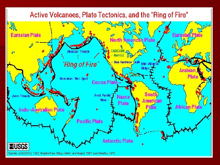
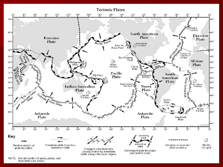
Three Types of Plate Boundaries 1. Convergent – 2 plates moving together (colliding) 2. Divergent – 2 plates moving apart 3. Transform – 2 plates moving past one another.
There are Three Types of Convergent Plate Boundaries n Oceanic Plate with Continental Plate n Oceanic Plate with Oceanic Plate n Continental Plate with Continental Plate
Convergent Plate Boundary – (Oceanic – Continental) Example : Peru – Chile Trench – See ERT
Convergent Plate Boundary (oceanic / continental collision) n n n 1. ocean plate is more dense than continental plate therefore goes under continent. 2. deep sea trench is formed 3. mountain building processes 4. earthquake activity due to the contact between plates 5. volcanism due to the melting of the plate materials [meting of continental (felsic) material causes explosive volcanoes]
Subduction Zone n Subduction Zone – Convergent plate boundary where one plate is pulled under another to be re-melted in the mantle
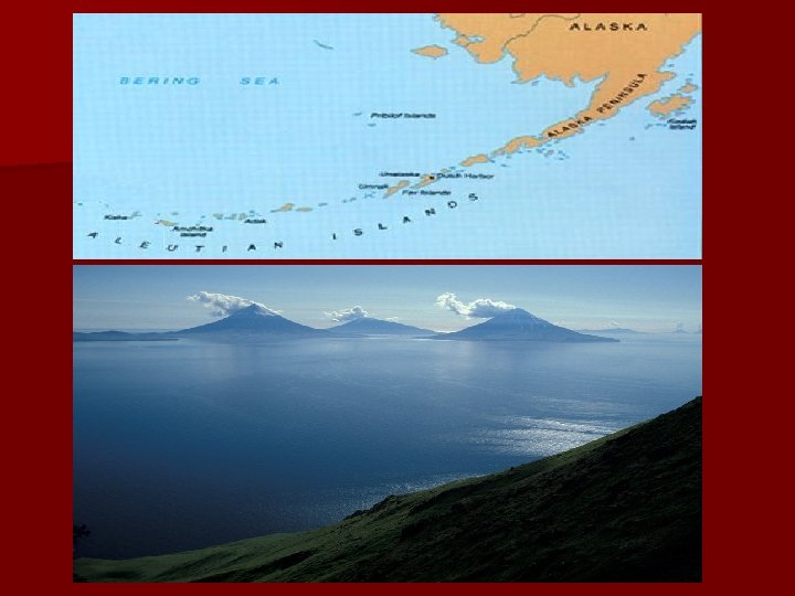
Convergent Plate Boundary (oceanic – oceanic plates collide) Example: Aleutian Islands, Islands of Japan
Convergent Plate Boundaries (oceanic plate - oceanic plate collision) 1. 2. 3. 4. Subduction Island Arch – Partial melting of plate forms a curved line of volcanic islands oceanic trench earthquakes at plate contact
Continent – Continent plate boundary
Convergent Plate Boundary (continental – continental ) n 1. Major mountain building due to extreme folding of the continental crust (some of the highest mountains in the world form) n 2. One plate is subducted with much resistance forming huge mountains.
Himalayan Mountains
Divergent Plate Boundary Example: Mid-Atlantic Ridge
Divergent Plate Boundary n Mid-Ocean Ridges – Oceanic plates move away from each other. n Characteristics: n 1. mid-ocean ridges n 2. rift valley n 3. new ocean floor material (basalt – dense, mafic)
Transform plate boundary
Transform Plate Boundary n Transform Plate Boundary – Two plates slip past each other n Characteristics: n 1. plates move in opposite directions while moving parallel to each other.
Transform Plate Boundary n Example: San Andreas Fault (California)
Transform Plate Boundary
San Andreas Fault
The San Andreas Fault Running Through An Orchard n see the diagonal line that runs through the orchard in the incredible photo above? that's the san andreas fault - a point where the edges of 2 tectonic plates meet producing a visible displacement amongst the rows of trees. when they were planted years ago the rows were straight, but as the 2 ginormous land masses moved in opposite directions and rubbed against each other over the years the orchard was split. the top half of the field sits on the pacific plate, the bottom half on the north american plate.
Earthquake occurrences
Hot spots n Area at the center of a plate where molten material has melted through the plate and created a volcano – Hawaiian islands are over a hot spot
3 parts of the continent n Shield – Oldest part of the continent n Stable Platform – Area of undisturbed sediments eroded from the shield. Flat horizontal layers n Folded mountains – area of folded faulted rocks at the edge of the continent.
Canadian Shield
Continental Accretion n Growth of the continent through addition of material at its edges – Oldest part of continent is in the center
Isostacy n. A state of balance in the earths crust. Any change in one part of the crust will be offset by and equal and opposite change in another part. – Crust is floating on the mantle – Crust is thickest under the continents thinnest under the ocean
Geosyncline n. A place where the earths crust is sinking as sediments are piled into it. – Sediment layers thousands of feet thick build up