Noel 2007 Chronicle Herald Noel Storm History 28


 near Halifax • Set replay end time at 4 November 0400")
 – Compare the CAPPI 1.")
 Cape Breton Island • Set replay end time at 4 November")


")
. The sting at the end of the tail:")
- Slides: 32
Noel 2007 Chronicle Herald
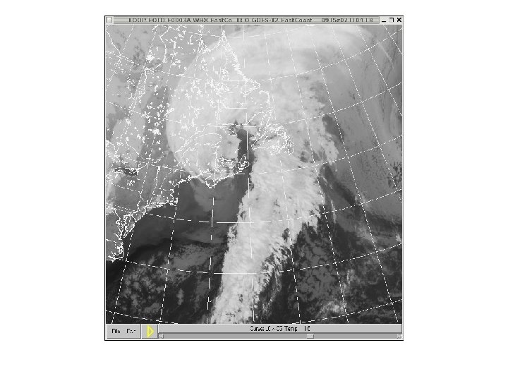
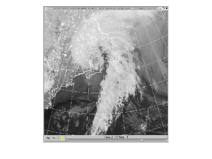
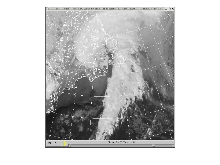
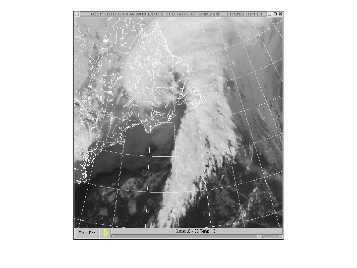
Noel: Storm History • 28 October – 4 November, 2007 • Slow moving tropical storm moved through the Caribbean – torrential rains from slowly moving storm devastated the Dominican Republic, Haiti, Jamaica, E. Cuba and the Bahamas – 163 deaths, thousands of homes destroyed or damaged – 80, 000 evacuated in Cuba – mostly a rain event in the Caribbean
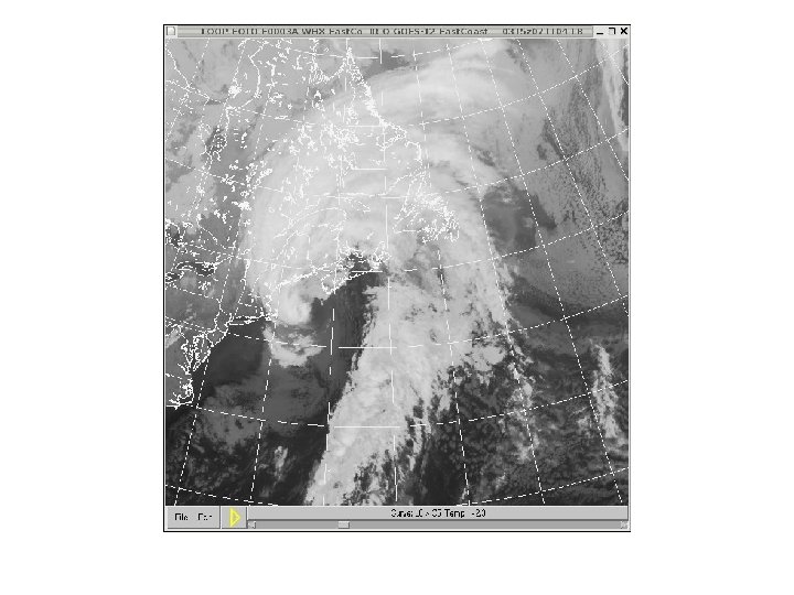
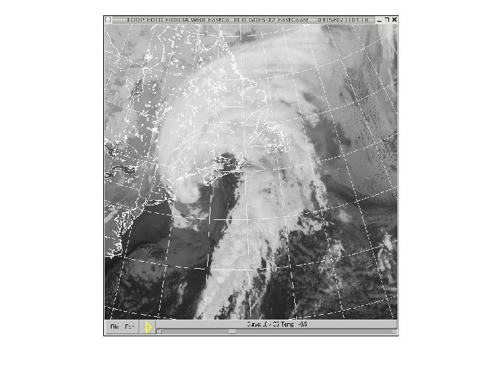
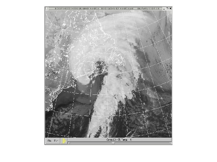
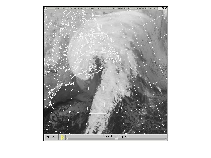
Noel: Storm History • Winds increased to Hurricane force only after passing the Bahamas • Extra-tropical transition SE of Cape Hatteras • Hurricane-force winds as it moved over Yarmouth (western tip of Nova Scotia), into the Bay of Fundy, southeastern New Brunswick then into the Gulf of St. Lawrence • Coastal storm surge damage along the south coast of Nova Scotia • Max rain amounts over southeastern Gaspe Peninsula (135 mm) and 60+ cm of snow in the Mountains of the Gaspe
WBV YHZ WCP
• • • • • • • UNOFF CWCP 040046 Z AUTO 10034 KT 16/15 RMK PK WND 1039 0020 Z PRESFR ALTM MISG SLP 868 58100= UNOFF CWCP 040146 Z AUTO 12032 G 39 KT 16/16 RMK PK WND 1253 0121 Z PRESFR ALTM MISG SLP 845 56091= UNOFF CWCP 040246 Z AUTO 13032 G 42 KT 17/16 RMK PK WND 1345 0153 Z PRESFR ALTM MISG SLP 813 56091= UNOFF CWCP 040346 Z AUTO 14035 G 43 KT 16/14 RMK PK WND 1554 0313 Z PRESFR ALTM MISG SLP 778 58090= UNOFF CWCP 040446 Z AUTO 14045 G 60 KT 14/12 RMK PK WND 1460 0442 Z PRESFR ALTM MISG SLP 741 58104= UNOFF CWCP 040546 Z AUTO 14044 G 54 KT 12/11 RMK PK WND 1568 0503 Z PRESFR ALTM MISG SLP 685 58128= UNOFF CWCP 040646 Z AUTO 21039 G 49 KT 11/10 RMK PK WND 1453 0550 Z PRESRR ALTM MISG SLP 709 55069= UNOFF CWCP 040746 Z AUTO 22039 G 52 KT 10/09 RMK PK WND 2252 0745 Z PRESRR ALTM MISG SLP 776 53035= UNOFF CWCP 040846 Z AUTO 25048 G 58 KT 07/06 RMK PK WND 2460 0825 Z PRESRR ALTM MISG SLP 859 53174= UNOFF CWCP 040946 Z AUTO 25044 G 55 KT 08/05 RMK PK WND 2560 0859 Z PRESRR ALTM MISG SLP 907 51198= UNOFF CWCP 041046 Z AUTO 26041 G 51 KT 08/04 RMK PK WND 2553 1006 Z PRESRR ALTM MISG SLP 940 51164= UNOFF CWCP 041146 Z AUTO 26036 G 45 KT 09/04 RMK PK WND 2652 1052 Z PRESRR ALTM MISG SLP 970 51111= UNOFF CWCP 041246 Z AUTO 25031 G 38 KT 09/05 RMK PK WND 2643 1150 Z PRESRR ALTM • NOTE THAT T and Td DROPPED WITH THE GUSTY WINDS PRIOR TO THE WINDSHIFT AND PRESSURE JUMP !! IS THIS EVIDENCE OF EVAPORATIVELY COOLED AIR IN THE DRY SLOT BEING MIXED TO THE SURFACE?
• • • • • • • • METAR CYHZ 040200 Z 13029 G 44 KT 2 SM -RA BR OVC 005 15/15 A 2941 RMK ST 8 PRESFR RERA /R 10/ SLP 964 SKYXX= SPECI CYHZ 040227 Z 14032 G 48 KT 1 1/2 SM -RA BR OVC 002 RMK ST 8 SKYXX= METAR CYHZ 040300 Z 14033 G 50 KT 2 SM -RA BR OVC 003 16/16 A 2932 RMK ST 8 SLP 929 58095 SKYXX= METAR CYHZ 040400 Z 14034 G 45 KT 1 1/2 SM -RA BR VV 001 16/16 A 2922 RMK FG 8 PRESFR SLP 895 SKYXX= METAR CYHZ 040500 Z 14037 G 52 KT 1 1/2 SM -RA BR OVC 002 17/17 A 2910 RMK ST 8 PRESFR SLP 856 SKYXX= SPECI CYHZ 040520 Z 14036 G 46 KT 1 1/2 SM RA BR OVC 004 RMK ST 8 PRESFP SKYXX= SPECI CYHZ 040539 Z 15036 G 50 KT 3 SM -RA BR OVC 004 RMK ST 8 RERA SKYXX= METAR CYHZ 040600 Z 15036 G 52 KT 3 SM -RA BR OVC 004 17/17 A 2902 RMK ST 8 PRESFR RERA SLP 827 58100 SKYXX= METAR CYHZ 040700 Z CCA 16050 G 61 KT 5 SM -RA BR SCT 008 OVC 012 15/15 A 2893 RMK SC 4 PRESFR SLP 797 SKYXX= SPECI CYHZ 040734 Z 16041 G 59 KT 2 SM -DZ BR OVC 012 RMK SC 8 SKYXX= METAR CYHZ 040800 Z 17035 G 56 KT 1 1/2 SM -SHRA BR OVC 010 12/12 A 2884 RMK ST 8 PRESFR SLP 768 SKYXX= METAR CYHZ 040900 Z 18036 G 51 KT 2 SM -RA BR OVC 005 10/10 A 2882 RMK ST 8 SLP 760 56067 SKYXX= METAR CYHZ 041000 Z 20032 G 44 KT 3 SM -RA BR OVC 004 10/10 A 2888 RMK ST 8 PRESRR SLP 780 SKYXX= METAR CYHZ 041100 Z 23035 G 55 KT 6 SM -RA BR OVC 011 08/08 A 2899 RMK ST 8 PRESRR SLP 819 SKYXX= SPECI CYHZ 041123 Z 24029 G 49 KT 12 SM BKN 012 BKN 022 RMK ST 5 SC 2 PRESRR SKY 99= METAR CYHZ 041200 Z 24025 G 39 KT 15 SM BKN 015 OVC 025 06/05 A 2917 RMK SC 5 SC 3 PRESRR SLP 879 53117 SKYXX= METAR CYHZ 041300 Z 25026 G 40 KT 15 SM BKN 013 OVC 025 06/05 A 2928 RMK SC 5 SC 3 PRESRR SLP 915 SKYXX= METAR CYHZ 041400 Z 24023 G 32 KT 15 SM OVC 019 07/05 A 2937 RMK SC 8 PRESRR SLP 947 SKYXX= METAR CYHZ 041500 Z 23023 G 31 KT 15 SM OVC 017 07/05 A 2946 RMK SC 8 PRESRR SLP 977
• • • • • • • UNOFF CXMI 040200 Z AUTO 12039 G 46 KT 15/14 RMK PK WND 1148 0129 Z PRESFR ALTM MISG SLP 940 58098= UNOFF CXMI 040300 Z AUTO 13044 G 53 KT 16/14 RMK PK WND 1353 0251 Z PRESFR ALTM MISG SLP 909 56098= UNOFF CXMI 040400 Z AUTO 13043 G 50 KT 16/15 RMK PK WND 1452 0347 Z PRESFR ALTM MISG SLP 879 56095= UNOFF CXMI 040500 Z AUTO 13045 G 53 KT 16/15 RMK PK WND 1353 0458 Z PRESFR ALTM MISG SLP 839 58101= UNOFF CXMI 040600 Z AUTO 14043 G 52 KT 17/15 RMK PK WND 1363 0517 Z PRESFR ALTM MISG SLP 819 56090= UNOFF CXMI 040700 Z AUTO 16049 G 58 KT 15/12 RMK PK WND 1665 0621 Z PRESFR ALTM MISG SLP 787 56092= UNOFF CXMI 040800 Z AUTO 17061 G 73 KT 12/10 RMK PK WND 1773 0757 Z PRESFR ALTM MISG SLP 753 58086= UNOFF CXMI 040900 Z AUTO 18049 G 62 KT 10/09 RMK PK WND 1769 0801 Z ALTM MISG SLP 753 56066= UNOFF CXMI 041000 Z AUTO 21046 G 61 KT 10/08 RMK PK WND 1965 0919 Z PRESRR ALTM MISG SLP 798 53011= UNOFF CXMI 041100 Z AUTO 24043 G 63 KT 08/04 RMK PK WND 2171 1022 Z PRESRR ALTM MISG SLP 858 53105= UNOFF CXMI 041200 Z AUTO 24034 G 47 KT 08/04 RMK PK WND 2352 1137 Z PRESRR ALTM MISG SLP 901 51148= UNOFF CXMI 041300 Z AUTO 25026 G 39 KT 07/04 RMK PK WND 2554 1216 Z PRESRR ALTM MISG SLP 935 51137= UNOFF CXMI 041400 Z AUTO 25026 G 37 KT 08/04 RMK PK WND 2439 1302 Z PRESRR ALTM MISG SLP 965 51107= UNOFF CXMI 041500 Z AUTO 24022 G 32 KT 09/04 RMK PK WND 2336 1431 Z PRESRR ALTM MISG
UNOFF CWBV 040600 Z AUTO 15045 G 52 KT 16/15 RMK PK WND 1557 0535 Z PRESFR ALTM MISG SLP 866 58099= UNOFF CWBV 040640 Z AUTO 15047 G 59 KT 15/14 RMK PRESFR ALTM MISG SLP 840 58103= UNOFF CWBV 040700 Z AUTO 15047 G 61 KT 15/14 RMK PK WND 1661 0654 Z PRESFR ALTM MISG SLP 836 58096= UNOFF CWBV 040740 Z AUTO 18045 G 60 KT 14/14 RMK ALTM MISG SLP 840 56076= UNOFF CWBV 040800 Z AUTO 17041 G 50 KT 14/13 RMK PK WND 1860 0732 Z ALTM MISG SLP 831 56074= UNOFF CWBV 040840 Z AUTO 18046 G 59 KT 13/11 RMK PRESFR ALTM MISG SLP 814 56066= UNOFF CWBV 040900 Z AUTO 18054 G 68 KT 12/10 RMK PK WND 1868 0856 Z PRESFR ALTM MISG SLP 810 56056= UNOFF CWBV 040940 Z AUTO 19058 G 72 KT 10/09 RMK ALTM MISG SLP 798 58042= UNOFF CWBV 041000 Z AUTO 19056 G 71 KT 10/08 RMK PK WND 1974 0941 Z ALTM MISG SLP 796 58040= UNOFF CWBV 041040 Z AUTO 20055 G 73 KT 10/08 RMK ALTM MISG SLP 816 55024= UNOFF CWBV 041100 Z AUTO 21052 G 65 KT 09/08 RMK PK WND 2074 1032 Z PRESRR ALTM MISG SLP 830 55001= UNOFF CWBV 041140 Z AUTO 22056 G 66 KT 09/06 RMK PRESRR ALTM MISG SLP 860 53046= UNOFF CWBV 041200 Z AUTO 23053 G 66 KT 09/07 RMK PK WND 2270 1103 Z PRESRR ALTM MISG SLP 882 53072=
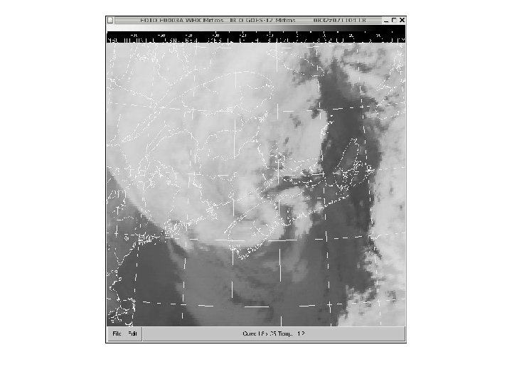
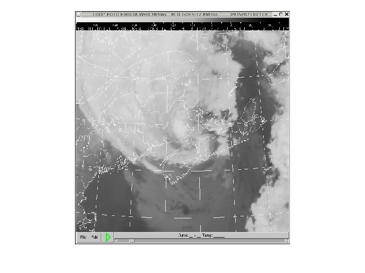
Gore Radar (XGO) near Halifax • Set replay end time at 4 November 0400 Z, loop length 6 hours, run the SERF, try some cross sections too – Describe the nature of the precipitation • Stratiform vs convective, banded, sloped? • Plot the Velocity Azimuth Display (VAD) and loop – What is the shape of the hodograph? What does this imply about the nature of the system (tropical vs extratropical)? How do the winds near the surface compare with observed gusts? – Which side of Gore is the system passing? How do you know? – Is there a steering flow? If so, how does it change with time?
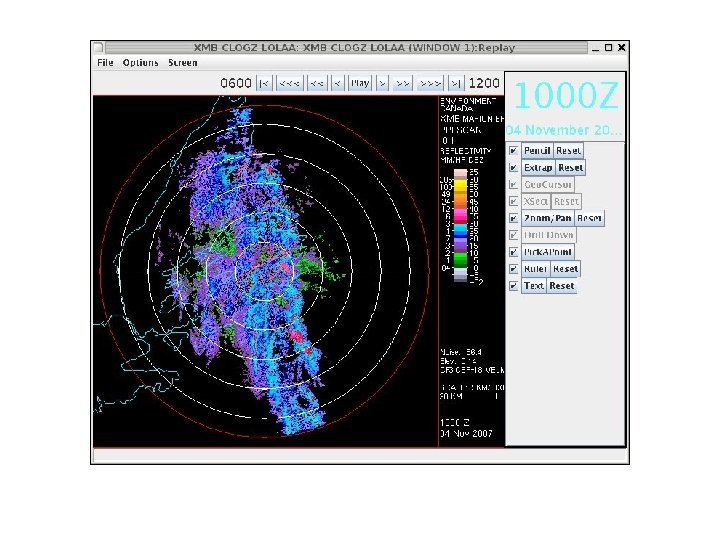
Compositing • Run the Winter Drill Down Display (WIDDS) – Compare the CAPPI 1. 0 W (winter) with the CAPPI 1. 5 (rain) • Do you notice a difference in the method of compositing? – Examine the 3 HR PA Sn (3 hour precip accumulation – snow) • What method of compositing is being used for snow? Can you think why this method was chosen? – What is causing the “ridges” in the PA product?
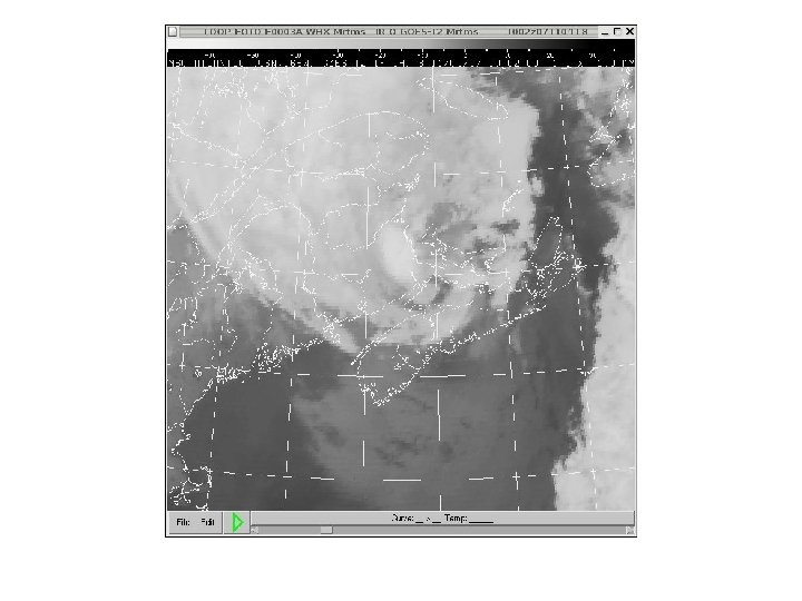
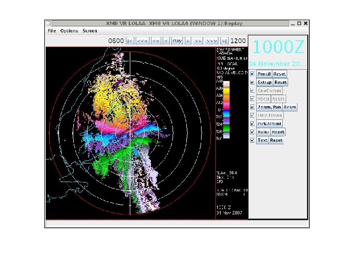
Marion Bridge (XMB) Cape Breton Island • Set replay end time at 4 November 1100 Z, loop length 2 hours, run the SERF – Comment on the structure of reflectivity and the strength of the winds crossing Cape Breton
“Sting Jets” • Term coined by British researcher Keith Browning • Narrow zone of strong, gusty wind observed in the dry slots of rapid deepeners • Crescent-shaped low-cloud bands sometimes observed in satellite imagery • Possibly linked to slantwise convection mixing high velocity air to the surface • Zone of strongest winds appears on satellite imagery just ahead of the tip of the comma head
From Browning and Field 2004
Conceptual model of a dry, high-momentum sting-jet outflow interacting with a colder and relatively moist boundary layer to produce strong wind gusts at the surface just behind a convergence line detectable as a line of boundary-layer cloud. (Browning and Field 2004)
Example from “Great Storm of 1987” in England * Meteosat infra-red images for (a) 0130 UTC and (b) 0230 UTC, 16 October 1987, using the E 1 enhancement scheme to show the structure of the middle- and high-level cloud. Axes of three cloud-head bands, a, b and c (and four others), are denoted by red lines. The blue lines, labelled A, B and C, show the axes of boundary-layer convergence lines. The green lines show the surface frontal analysis. L is the surface lowpressure centre and the small white asterisk in (a) denotes the centre of the region of strongest surface winds. (Browning and Fields 2004)
References • Browning, K. A. (2004). The sting at the end of the tail: damaging winds associated with extratropical cyclones. Q. J. R. Meteorol. Soc. 130: 375 -399. • Clark, P. A. & Browning, K. A. (2005) The sting at the end of the tail: model diagnostics of fine scale 3 D structure of the cloud head. Q. J. R. Meteorol. Soc. 131: 2263 -2292. • Browning, K. A. and M. Field (2004). Evidence from Meteosat imagery of the interaction of sting jets with the boundary layer. Meteorol. Appl. 11, 277– 289.