Geology Department Geophysics I Lecture 3 Reduction of
 Lecture 3 Reduction of Gravity Data")
 of Gravity Data Factors that Affect the Gravitational Acceleration A-Temporal Based Variations 1")


 - Gravity readings observed at each gravity station after corrections")


 is used to account for")

 The free-air and Bouguer corrections are commonly combined into one")

- Slides: 15
Geology Department Geophysics (I) Lecture 3 Reduction of Gravity Data
Reduction(Corrections) of Gravity Data Factors that Affect the Gravitational Acceleration A-Temporal Based Variations 1 -Instrument Drift 2 - Tidal Affects B- Spatial Based Variations 3 -Latitude Variations 4 -Elevation Variations. 5 -Slab Effects 6 -Topographic Effects. 7 -Building Effects, 8 - EÖtvÖs Effects, and 9 - Isostatic Effects
Instrument Drift - A gradual and unintentional change in the reference value with respect to which measurements are made the properties of the materials used to construct the spring can change with time. These variations in spring properties with time can be due to stretching of the spring over time or to changes in spring properties related to temperature changes. To help minimize the later, gravimeters are either temperature controlled or constructed out of materials that are relatively insensitive to temperature changes. Even still, gravimeters can drift as much as 0. 1 mgal per day.
Tidal Effect Definition: Variations in gravity observations resulting from the attraction of the moon and sun and the distortion of the earth so produced. This distortion of the solid earth produces measurable changes in the gravitational acceleration because as the shape of the earth changes, the distance of the gravimeter to the center of the earth changes (recall that gravitational acceleration is proportional to one over distance squared). The distortion of the earth varies from location to location, but it can be large enough to produce variations acceleration as large as 0. 2 mgals. in gravitational
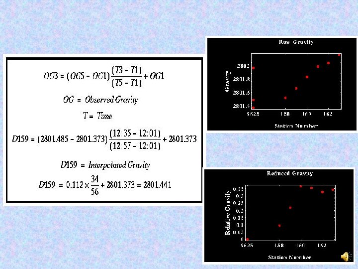
Tidal and Drift Corrections: Data Reduction
Base Station - A reference station that is used to establish additional stations in relation there to. Quantities under investigation have values at the base station that are known (or assumed to be known) accurately. Data from the base station may be used to normalize data from other stations. looping procedure with one loop of the survey being bounded by two occupations of the base station. The looping procedure defined here is the simplest to implement in the field. The basis for these corrections will be the use of linear interpolation to generate a prediction of what the time-varying component of the gravity field should look like.
1 - Latitude Correction Latitude Variations - Changes in the observed acceleration caused by the ellipsoidal shape and the rotation of the earth
Observed gravity (gobs ) - Gravity readings observed at each gravity station after corrections have been applied for instrument drift and earth tides The latitude correction is usually made by subtracting theoretical gravity calculated using the International Gravity Formula (gϕ) from the observed value (gobs) For small-scale surveys, the local latitude correction Cϕ = 0. 812 sin 2ϕ mgal/ km (north-south) It is must be subtracted from or added to, the measured gravity depending on whether the station is on higher or lower latitude the base station.
2 - The Free-Air Correction Often we make observations at different elevations, and we know that gravity will decrease as we get farther from the center of mass of the Earth. Therefore, we choose a reference elevation (typically sea level) and adjust our readings to be what they would be at that elevation. Most land surveys are done above sea level, so the free air correction will generally increase the gravity reading.
2 - The Free-Air Correction
3 -The Bouguer Correction The Bouguer correction (δg. B) is used to account for the rock mass between the measuring station and sea-level (After Pierre Bouguer). The Bouguer correction calculates the extra gravitational pull exerted by a rock slab of thickness h metres and mean density ρ (Mg/m 3) which results in measurements of gravity (gobs).
The Bouguer correction should be subtracted from the observed gravity value for stations above sea-level. For marine surveys, the Bouguer correction is slightly different in that the low density of seawater is effectively replaced by an equivalent thickness of rock of a specified density The form of the Bouguer gravity anomaly, gb, is given by where r is the average density of the rocks underlying the survey area
Elevation correction (δg. E) The free-air and Bouguer corrections are commonly combined into one elevation correction (δg. E) to simplify data handling
The next lecture 1 -Continue corrections of the gravity data 2 -Isostacy theory 3 - Calculation Gravity anomalies associated with geometric forms 4 -Regionals and residuals