EMFF UP 6 Fostering the Implementation of Integrated


 D 6. 2 D 6.")

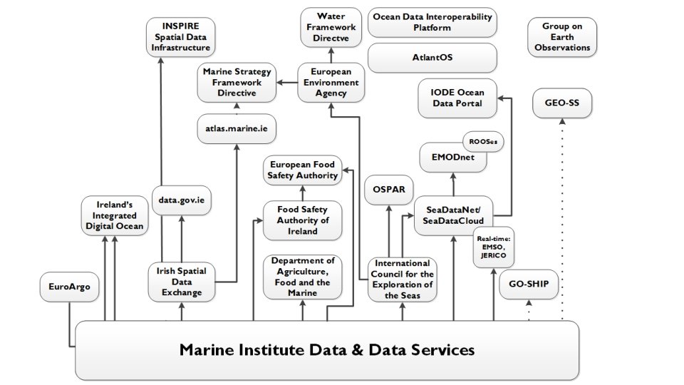
 Outputs Data Product or Service Data Governance")
 • Invitation to Tender currently in preparation; • Marine Invasive")
- Slides: 12
EMFF UP 6 : Fostering the Implementation of Integrated Maritime Policy Blue Growth & Maritime Spatial Planning Scheme MSP Projects 2018 3 rd May 2018 Jeff Fisher, MEFS
MSP in Ireland • SI 352 of 2016: European Union (Framework for Maritime Spatial Planning) regulations 2016; • National MSP work programme is underway; • EMFF-funded MSP Technical and Scientific Work Programme underway: – Spatial Data and Evidence (SDE) projects (5) – MSP Data Management requirements (2) – Research (Invasive Marine Species) (2).
MSP Roadmap – published December 2017 Stage Milestone Timeframe Activation Stage 1. Establish and resource MSP function in Department of Housing, Planning and Local Government 2. Identify and initiate contact with key stakeholders Immediate – complete Now – end 2017 Development Stage 1. Establish MSP Inter Agency Group 2. Develop road map – Towards a Marine Spatial Plan 3. Initiate contact with broader external stakeholder group (e. g. energy industry reps, fisheries, coastal communities…) End November 2017 Publish before end 2017 In writing before end 2017 Regional workshop/ stakeholder fora Q 1 2018 4. Prepare issues paper (this phase includes collection, mapping and analysis of data on current conditions) Finalisation Stage Implementation and Review Stage Publish Sept 2018 o 2 month consultation 5. Prepare draft MSP (including Environmental Assessments) To Minister/Government Q 2 2019 3 month consultation 1. Prepare final MSP (including Environmental Assessments) To Minister/Government Q 2 2020 Publish and notify European Commission – Q 3 2020 1. Implementation and review 2020 onwards
Spatial Data and evidence projects • kick-off meeting - Feb 2018 • Partners:
Spatial Data and Evidence projects 1. Data Discovery, Collation and Gap Analysis • • Catalogue of spatial, environmental, socio-economic data; Delivery of spatial data (marine activities, key species, ecosystems); Review of quality of data /metadata; Data gap analysis. 2. Data Prioritisation and Collection • • Prioritisation of data gaps; Continued delivery of spatial data: • Maps of marine activities required under the MSP Directive • Resource maps to inform MSP • Maps of pressures. 3. Assess and Map Marine Ecosystems Services • • • Characterisation of Ireland’s marine ecosystem services; Maps of Ireland’s marine ecosystem services; Evidence base on the value of natural capital and ES; Report identifying and mapping threats and opportunities; Maps and information showing the sectors and communities that will benefit. 4. Mapping the Potential Impacts of Climate Change • • • Best practice on climate change in marine spatial planning; Scenario output maps (marine ES and activities); Implications of sea level rise on coastal infrastructure. 5. Best Practice on Modelling and Support Tools for Integrating Marine Spatial Data • • Best practice models for spatial data management and integration; Review of existing products that can add value to spatial data.
MSP Data Management 6. Data Integration for Improved Spatial Analysis and Representation • Data usage agreements for MSP relevant datasets; • Data standards to allow the integration / reuse of data for MSP purposes; • Inspire compliant metadata ; • Data process flows required for MSP; • Procedures documented for handling of prioritised datasets to ensure the quality and availability of MSP data. 7. MSP Data governance • Data Management framework (data storage, retention / disposal, and access control etc. ); • Data Management Plans; • Data Governance Policy to define how data can be used for MSP services; • Initial MSP Data Catalogue system; • Initial MSP Data Storage and Management.
Data Quality Framework – what’s it all about? MI Quality Framework Working Group - Who MI Data Quality Management System - What Quality Management Framework (QMF) - How International Oceanographic Data & Information Exchange (IODE) of the Intergovernmental Oceanographic Commission (IOC) of UNESCO. • The quality management system (QMS) is based on the ISO 9001: 2015 quality management standard • •
EMFF – MSP Data Management Framework (D 7. 1) D 6. 2 D 6. 4 MSP Reuse & Standards Report Data Sources MI Data Key Procedures Ongoing assessment D 7. 3 Data Governance Policy • Data Quality Management System Data Products • Stored by MI • Stored External • • Access Classification Licensing Categorisation Update Catalogue D 7. 4 D 6. 1 Project 1 Data Catalogue (Provenance) D 6. 3 D 7. 4 MSP Storage & Mgmt. System Metadata of relevant data Data Management Planning (DMP) D 7. 2 1 Public Users - Open Data metadata - Open Data D 6. 1 D 6. 4 External Data Sources MSP Practitioners etc. - All metadata is available - Data restrictions / controls apply D 6. 5 Key Process Flows MI Data Quality Framework Apply MSP Relevance Filter Marine Spatial Planning (MSP): Outputs Quality Rating
MSP relevant datasets in Ireland's Marine Atlas 140 120 100 80 60 40 20 0 al number of datasets 1 25 2 7 3 8 4 6 5 53 6 5 7 49 8 4 9 27 10 118 11 57 12 62 13 3 14 23
Proposed Quality Management System (D 6. 5) Outputs Data Product or Service Data Governance Operations Design & Delivery Input from Customers & Interested Parties Processes Procedures GDPR Risks Acceptance Criteria Planning Requirements Gathering Standards & Methodology • • • Knowledge & Advice Performance Evaluation & Improvement Data Management Plan Inputs Quality Assurance MI Policy & Strategy Legislative Drivers Requirements Document MI Architecture Training & Resourcing Management Systems
Research (Invasive Marine Species) • Invitation to Tender currently in preparation; • Marine Invasive Species Surveillance Methods to Facilitate Spatial Mapping in Irish Nearshore and Foreshore Waters and Benthic Habitats; • Mapping Ireland’s Invasive Marine Species Incidence and Colonisation. • Close coordination with BIM and NPWS to ensure complimentary (not overlapping) effort through contracted work