CURRENTS HIGHWAYS OF THE SEA Highways of the


 to be")


- Slides: 31
CURRENTS HIGHWAYS OF THE SEA
Highways of the Sea vocabulary � western intensification contour currents � countercurrents � drogue � Downwellings � eddies � Upwellings � Ekman transport � gulf stream � Ekman spiral � gyre � Eulerian method � La Niňa � El Niňo Southern Oscillation � float method (ENSO � flow method � ocean conveyor belt � flotsam method � pressure gradient force � geostrophic currents � sea level � Doppler Acoustic Current � thermohaline circulation Meter � undercurrents � � Lagrangian method
Lesson 3: How do we Identify Ocean Currents with the Best Potential for Producing Energy? Types of Ocean Currents A current is any movement of water and may be driven by tides, winds, or differences in water density. Ø Tidal currents – Currents in the oceans, near the shore, and in bays and estuaries along the coast created by the rise and fall of tides; the only type of currents that change in a regular and predictable pattern Ø Wind-driven surface currents – Currents created by prevailing global wind patterns; surface currents will be the main focus of this lesson Ø Thermohaline circulation – The global circulation of ocean water created by density differences due to temperature (thermo-) and salinity (haline) in seawater
Surface Currents �Controlled by three factors • Global winds ◦ Coriolis Effect ◦ Continental Deflections
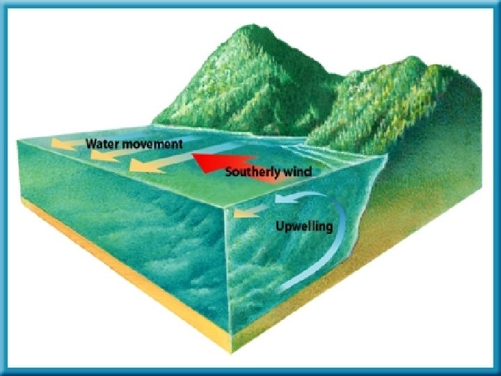
Upwelling Link �The movement of deep, cold, nutrient rich water to the surface �Nutrients promote growth of fish and plants �Areas are important fishing grounds
Lesson 3: How do we Identify Ocean Currents with the Best Potential for Producing Energy? Air Pressure & Wind is basically the movement of air currents from an area of high pressure to an area of low pressure. Pressure is the amount of force per unit area. Air pressure – The weight (force) of the column of air above a particular location, per unit area; air pressure depends on: Ø elevation or altitude (higher up means less air above) Ø average temperature of the air above (hot air is lighter than cold air) Ø composition of the air (oxygen, nitrogen, etc. )
Lesson 3: How do we Identify Ocean Currents with the Best Potential for Producing Energy? Air Pressure & Wind q Air circulation is driven by the pressure gradients that develop because of differences in the heating and cooling of the Earth’s surface.
Lesson 3: How do we Identify Ocean Currents with the Best Potential for Producing Energy? Global Wind Patterns Ø At the equator, surface winds are calm; this latitude is called the doldrums. Also known as the intertropical convergence zone (ITCZ) this belt of air around the equator receives much of the sun’s radiant energy, and the warm, rising air produces a low-pressure area extending many kilometers north and south of the equator.
Lesson 3: How do we Identify Ocean Currents with the Best Potential for Producing Energy? Global Wind Patterns Ø The horse latitudes are about 30 degrees north and south of the equator. Here the warm air rising from the equator cools and begins to sink. There are few clouds and little rainfall. At the horse latitudes, some of the sinking air travels back towards the equator and forms warm, steady winds, known as the trade winds.
Lesson 3: How do we Identify Ocean Currents with the Best Potential for Producing Energy? Global Wind Patterns Ø The westerlies are located between 40 to 60 degrees latitude in both hemispheres. The westerlies start rising and cooling as they approach the poles between 50 and 60 degrees latitude. They meet extremely cold air flowing toward the equator from the poles to form the polar easterlies.
Lesson 3: How do we Identify Ocean Currents with the Best Potential for Producing Energy? Surface Ocean Currents Ø Surface currents involve approximately 10% of the ocean’s water and usually extend from the surface to about 400 meters (1, 300 feet) in depth and are moved primarily by winds.
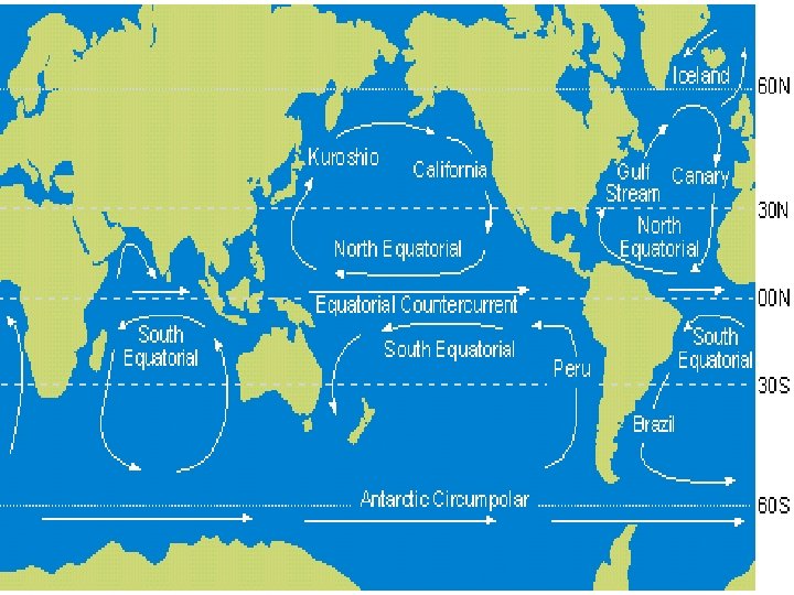
Lesson 3: How do we Identify Ocean Currents with the Best Potential for Producing Energy? Surface Currents Gyres are large-scale circulating bodies of surface water that occur in ocean basins Ø Five major subtropical gyres: North Atlantic, South Atlantic, North Pacific, South Pacific, and Indian Ocean gyres Ø Each subtropical gyre has four boundary currents Ø Boundary currents are located along the western, eastern, equatorial, and northern or southern (depending on the hemisphere) boundaries of a gyre
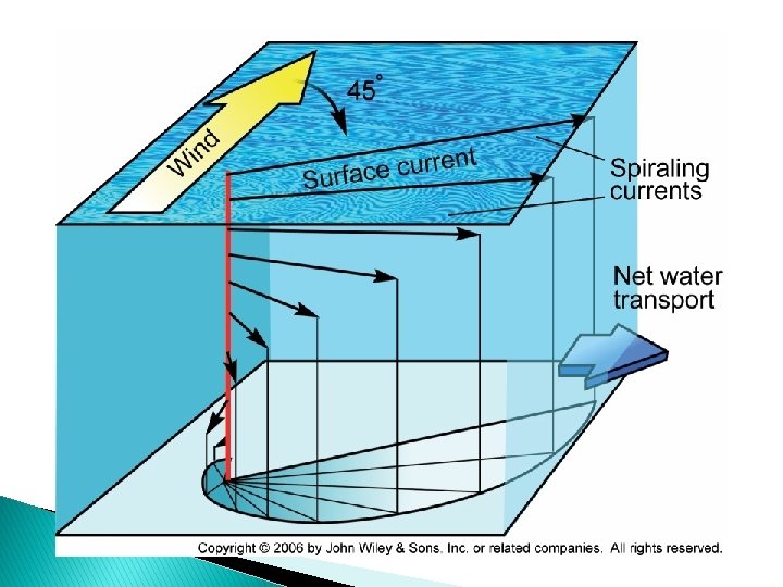
Ekman Transport � The friction of the wind causes the water to flow in layers. The moving water transfers energy through friction to deeper water. Each layer of deeper water will continue to move progressively to the right in the Northern Hemisphere & to the left in the Southern Hemisphere. � Velocity of the current decreases at depth as the energy dissipates.
Lesson 3: How do we Identify Ocean Currents with the Best Potential for Producing Energy? Surface Currents Other Factors That Influence Surface Circulation: Ø The Coriolis Effect Spin of the earth causing A deflection of the wind And water currents.
Lesson 3: How do we Identify Ocean Currents with the Best Potential for Producing Energy? Surface Currents Ø The boundary currents of a gyre flow in the same patterns due to the prevailing wind belts, friction, the Coriolis Effect, pressure gradients, and gravity. These drivers intensify the boundary current along the western arm of a gyre, a phenomenon known as westward intensification.
Lesson 3: How do we Identify Ocean Currents with the Best Potential for Producing Energy? Surface Currents Ø Subtropical gyres are important in regulating the Earth’s climate
� Westward intensification causes the boundary currents (Gulf Stream, Brazil & Kuroshio) to be narrower (less than 60 miles), deeper (1. 2 miles) and faster (100, s of kilometers per day). � These currents transport huge volumes of water
GULF STREAM CURRENT system Florida Current Gulf stream Current North Atlantic Current The Florida Current Carries warm tropical Waters that feed the Gulf Stream and plays a role in returning surface waters to the northern Atlantic from thermohaline circulation. Influences the climate of the East Coast of Florida (keeps us warmer in the winter & cooler in the summer)
Florida Current � � Flowing through the straits of Florida between US & Bahamas it transports more than 30 million cubic meters per second of seawater northward. WHY DOES THIS MATTER? It has the potential generating capacity of up to 10 gigawatts (GW). It has the potential for use of about 5 GW, the equivalent to 5 power plants. The current never stops but does vary throughout the year.
Heat Transport � Gyres keep climate balance � Current heat traveling along EQUATOR absorbs & stores � Current moves to colder latitudes (POLES), heat redistributes and dissipates � The current brings cooler water back to the equator DEEP WATER CIRCULATION (OCEANIC CONVEYOR BELT)
� As these currents pass by coastal regions of continents they influence: v WEATHER (heat & cold in current can change air temperature), tropical storms) v BIOLOGICAL PRODUCTIVITY v LONG-TERM CLIMATE (upwelling of n utrients)
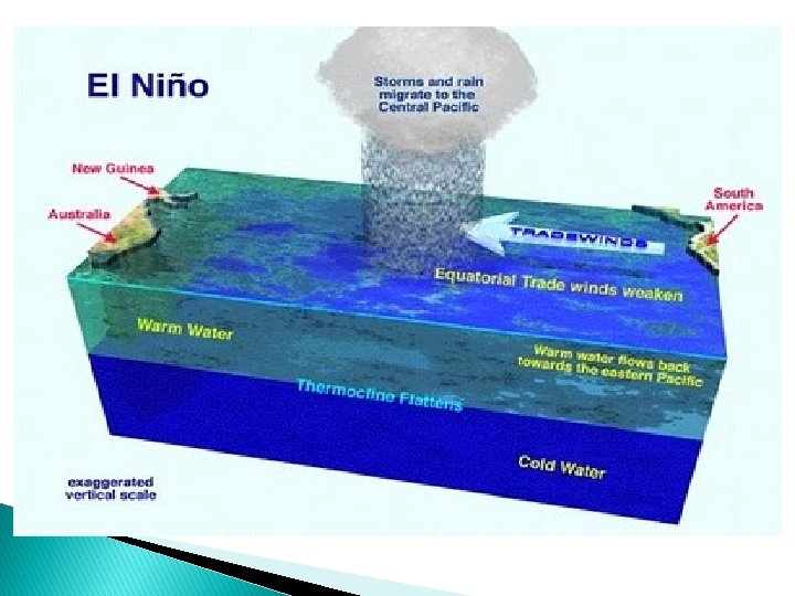
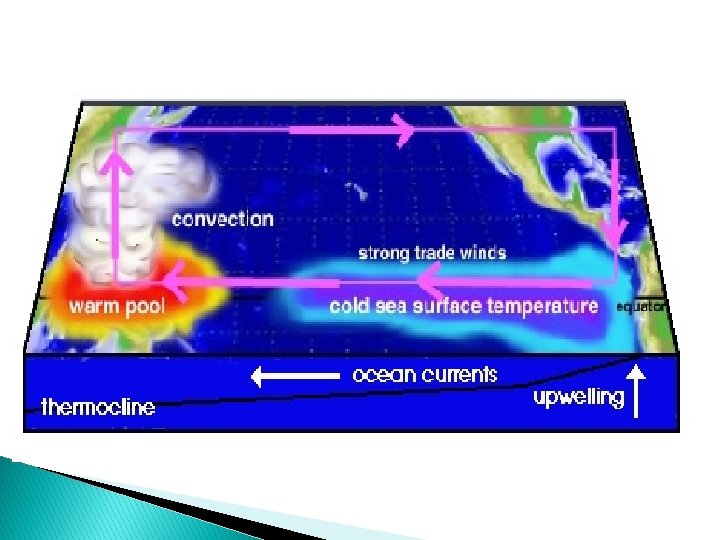
El Nino ◦ Change in the water temperature in the Pacific Ocean that produces a warm current
La Nina ◦ Change in the eastern Pacific Ocean in which the surface water temperature becomes unusually cool
Video Clip El Nino and La Nina � http: //player. discoveryeducation. com/index. c fm? guid. Asset. Id=174 A 7 F 2 E-4 CF 4 -4704 -AF 3 B 1566 A 0 F 0 A 744&bln. From. Search=1&productc ode=US
Studying currents Floating device released into current Lagrangian method � � Device in a fixed position measuring flow of current Eulerian method Acoustic Doppler Current Profiler (ADCP) Measures speed & velocity by emitting high frequency pulses of sound that bounce off moving particles in the water. (frequency changes are called “doppler shifts”) 4 acoustic transponders that emit and receive signals from four locations. *** can measure currents at different depths simultaneously
� CODAR Sea. Sonde Coastal Ocean Dynamic Application Radar � Land based and measure the surface of currents of the Coastal Ocean. � Transmitter sends out a radio frequency that scatters off the ocean surface and back to receiver attenna. (calculates speed and direction of surface current)