Chapter 4 Water Waves and Tides Karleskint Turner


 – ocean can maintain relatively constant")


 Chlorine (Cl 2) Sulfur Volcano Precipitation River discharge Organisms")


 waves are generated by wind and")
 – deepwater and shallow-water waves • deepwater waves—waves")
 – Tsunamis (large seismic sea waves) • seismic")


 the storm begins to weaken quickly")


- Slides: 63
Chapter 4 Water, Waves, and Tides Karleskint Turner Small
• 71% of Earths surface is covered with water • 97% salt water • 3% fresh water
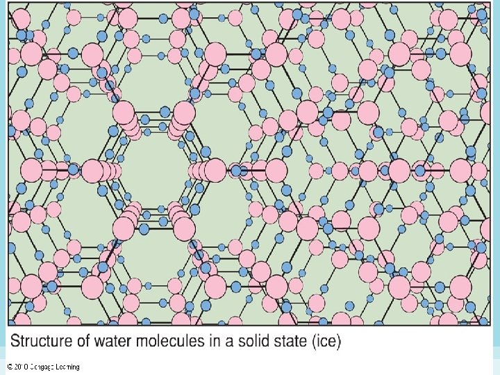
Nature of Water • Marine organisms are 70 – 80% water by mass. • Terrestrial organisms are approximately 66% water by mass! • Physical properties of water – – – excellent solvent high boiling point and freezing point denser in its liquid form than in its solid form supports marine organisms through buoyancy provides a medium for chemical reactions necessary for life
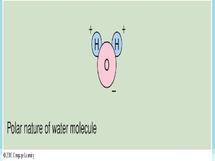
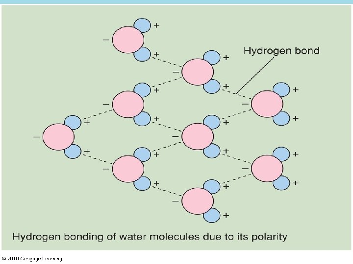
Nature of Water • Structure of a water molecule – 2 H atoms bonded to 1 O atom – polar - different parts of the molecule have different electrical charges: • the oxygen atom carries a slight negative charge; the hydrogen atoms carry a slight positive charge
Nature of Water • Specific heat (Thermal capacity) – ocean can maintain relatively constant temperature • Water and light – much light reflected into the atmosphere – different wavelengths (colors) of light penetrate to different depths
Nature of Water • Chemical properties of water – p. H scale measures acidity/alkalinity – ocean’s p. H is slightly alkaline (average 8) – organisms’ internal and external p. H affect life processes such as metabolism and growth
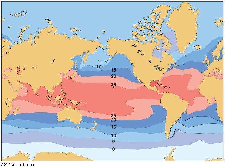
Salt Water • Salinity – seawater = 3. 5% salt, 96. 5% water – expressed as in g per kg water or parts per thousand (ppt) – salinity of surface water varies as a result of evaporation, precipitation, freezing, thawing, and freshwater runoff from land – areas around 30 o N and 30 o S = high salinity (evaporation > precipitation) – poles = high salinity (freezing – removes water from sea)
Hydrogen sulfide (H 2 S) Chlorine (Cl 2) Sulfur Volcano Precipitation River discharge Organisms die Chloride (Cl–) Sulfate (SO 42–) Sea spray removes salts Salts removed Calcium (Ca 2+) when organisms are Magnesium (Mg 2+) caught for food Carbonate (CO 32–) Potassium (K+) Calcium (Ca 2+) Sulfate (SO 42–) Sodium (Na+) Clay particles Magnesium (Mg 2+) Precipitation Bottom sediments adsorb Rock on the seafloor Stepped Art Fig. 4 -6, p. 75
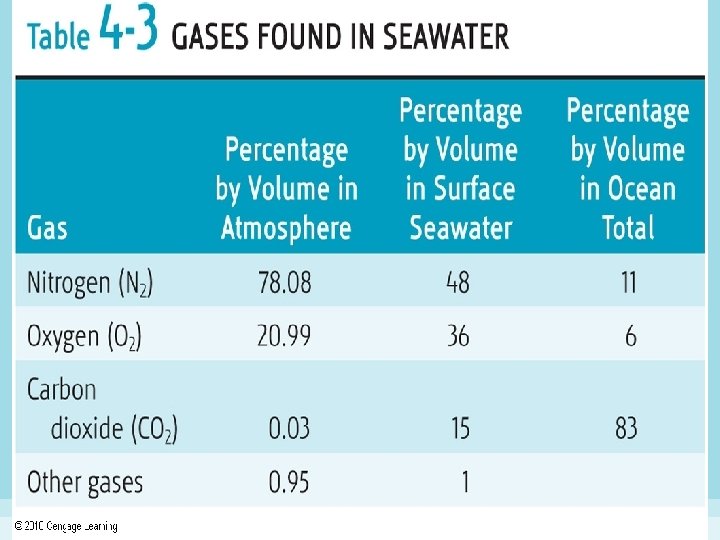
Salt Water • Gases in seawater – gases from biological processes • oxygen is a by-product of photosynthesis • release of CO 2 from respiration • oxygen-minimum zone – located just below sunlit surface waters – solubility of gases in seawater • seawater has more O and CO 2 but less N than the atmosphere • affected by temperature, salinity and pressure
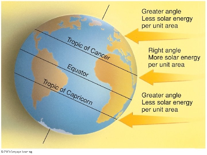
Ocean Heating and Cooling • Sea temperature – temperature varies daily and seasonally – affected by energy absorption at the surface, loss by evaporation, transfer by currents, warming/cooling of atmosphere, heat loss through radiation – seasonal variations in the amount of solar radiation reaching the earth, occur especially between 40 o and 60 o N and S because angle of sun’s rays change dramatically at these latitudes seasonally
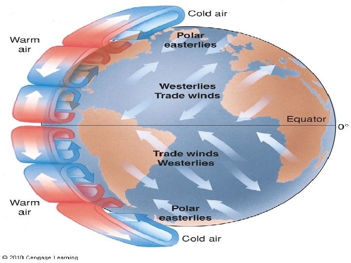
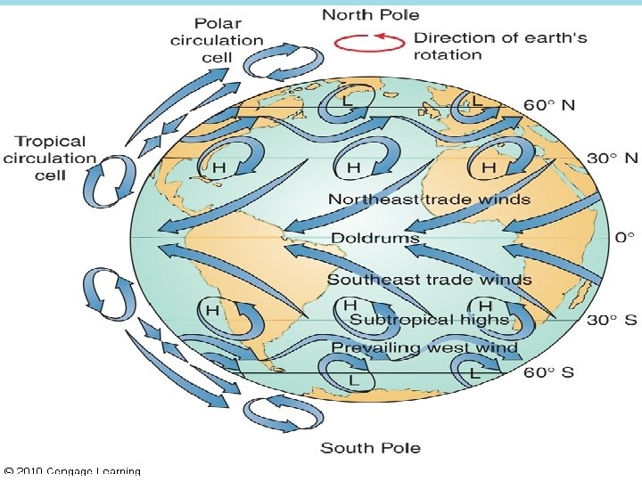
Winds and Currents • Winds – result from horizontal air movements caused by temperature, density, etc. – as air heats, its density decreases and it rises; as it cools, density increases and it falls toward earth – wind patterns: upper air flow from the equator towards the north and south
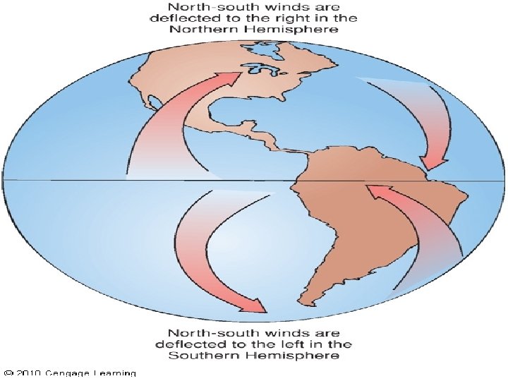
Winds and Currents • Winds – Coriolis effect • Apparent force on moving particles resulting from the earth’s rotation • path of air mass appears to curve relative to the earth’s surface—to the right in the Northern Hemisphere, left in the Southern
Winds and Currents • Surface wind patterns – 3 convection cells in each hemisphere: • northeast & southeast trade winds • westerlies • polar easterlies – areas of vertical air movement between wind belts • Doldrums (at equator) • horse latitudes (at 30 o N & S)
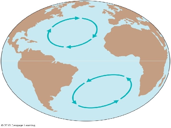
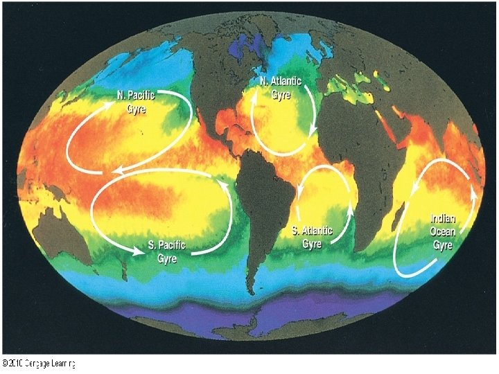
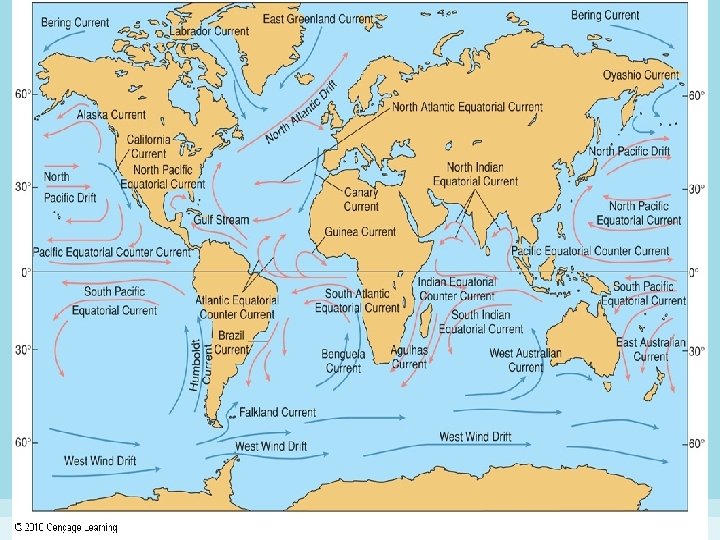
Winds and Currents • Ocean currents – surface currents • driven mainly by trade winds (easterlies and westerlies) in each hemisphere • Coriolis effect – deflection can be as much as 45 -degree angle from wind direction • gyres—water flow in a circular pattern around the edge of an ocean basin
Winds and Currents • Classification of currents – western-boundary currents: fastest, deepest currents that move warm water toward the poles in each gyre (e. g. Gulf Stream) – eastern-boundary currents: slow moving, carry cold water toward the equator – transverse currents: connect eastern- and westernboundary currents in each gyre – biological impact • western-boundary currents not productive, carry little nutrients, but increase oxygen mixed in water • eastern-boundary currents productive, nutrient-rich
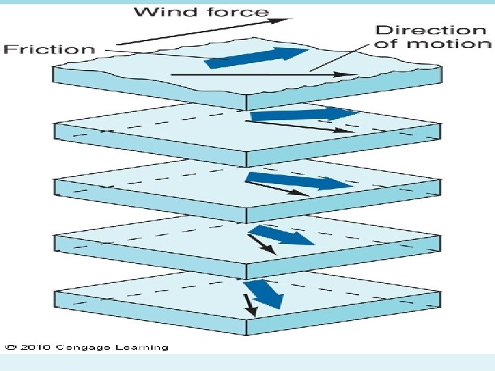
Winds and Currents • Currents below the surface – energy transferred from winds to surface water is transferred to deeper water – deeper-water currents are deflected by the Coriolis effect, down to about 100 m – friction causes loss of energy, so each layer moves at an angle to and more slowly than the layer above, creating an Ekman spiral – Ekman transport—net movement of water to the 100 -m depth
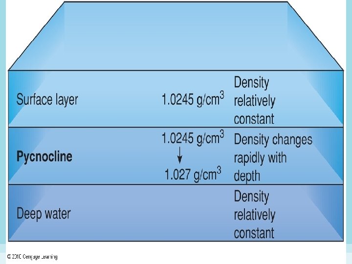
Ocean Layers and Ocean Mixing • Density increases when salinity increases • Density increases when temperature decreases
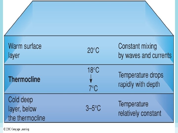
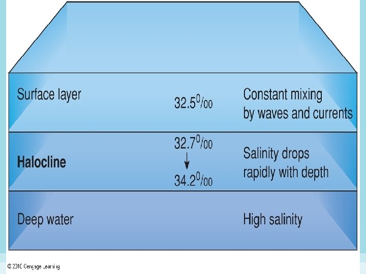
Ocean Layers and Ocean Mixing • Characteristics of ocean layers – depth 0 -100 m (330 feet): warmed by solar radiation, well mixed – 100 -1, 000 m: temperature decreases – thermocline – zone of rapid temperature change – halocline: salinity increases 0 -1, 000 m – pycnocline: 100 -1, 000 m, where changes in temperature and salinity create rapid increases in density – seasonal thermoclines
Ocean Layers and Ocean Mixing • Horizontal mixing – winter temperatures and increased salinity owing to freezing result in very dense water at the poles, which sinks toward the ocean floor
Ocean Layers and Ocean Mixing • Vertical mixing – isopycnal—stable water column that has the same density from top to bottom – vertical mixing allows water exchange between surface and deep waters – nutrient-rich bottom water is exchanged for oxygen-rich surface water
Ocean Layers and Ocean Mixing • Upwelling and downwelling – equatorial upwelling • water from currents on either side of the equator is deflected toward the poles, pulling surface water away to be replaced by deeper, nutrient-rich water – coastal upwelling • Ekman transport moves water offshore, to be replaced by deeper, nutrient-rich water – coastal downwelling • coastal winds force oxygen-rich surface waters downward and along the continental shelf
Ocean Layers and Ocean Mixing • Deepwater circulation – differences in density, not wind energy, cause water movement in deep oceans – dense Antarctic water sinks to the bottom and moves slowly toward the Arctic
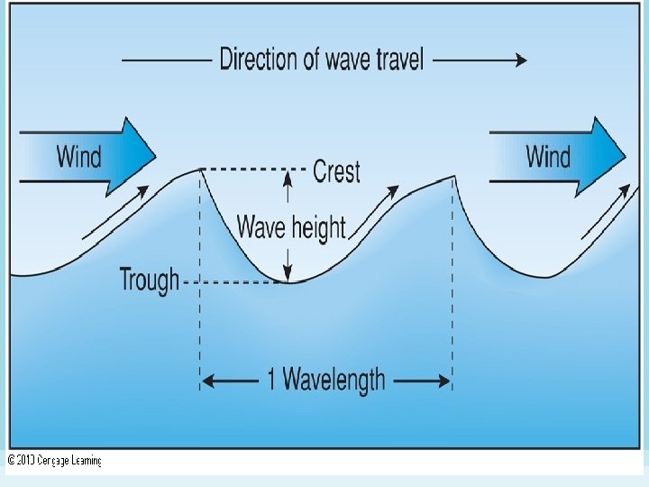
Waves • Wave formation – wave: a flow of energy or motion, not a flow of water – generating force: a force that disturbs the water’s surface, e. g. , wind, geological events, falling objects, ships
Waves • Types of waves – Progressive (forced) waves are generated by wind and restored by gravity, progress in a particular direction • forced waves are formed by storms, which determine their size and speed • free waves, no longer affected by the generating force, move at speeds determined by the wave’s length and period • swells are long-period, uniform free waves which carry considerable energy and can travel for thousands of km
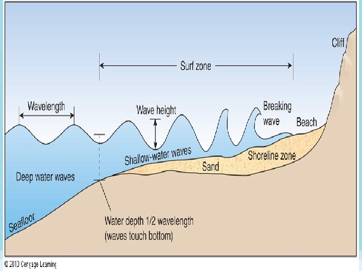
Waves • Types of Waves (con’t) – deepwater and shallow-water waves • deepwater waves—waves that occur in water that is deeper than ½ of a wave’s wavelength – breakers • deepwater waves become shallow-water waves when they move into shallow water • surf zone—area along a coast where waves slow down, become steeper, break, and disappear • breakers form when the wave’s bottom slows but its crest continues at a faster speed
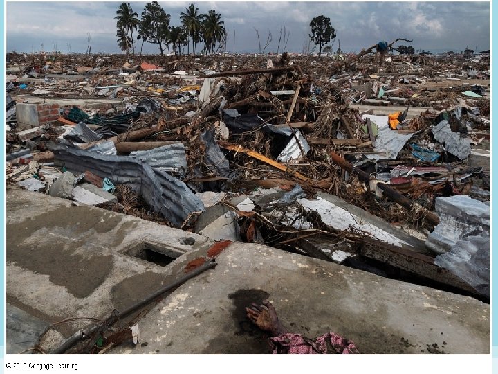
Waves • Types of Waves (con’t) – Tsunamis (large seismic sea waves) • seismic sea waves are formed by earthquakes • tsunamis have long wavelengths, long periods and low height • compression of the wave’s energy into a smaller volume upon approaching a coast or island causes a dramatic increase in height
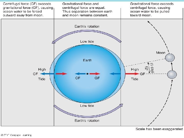
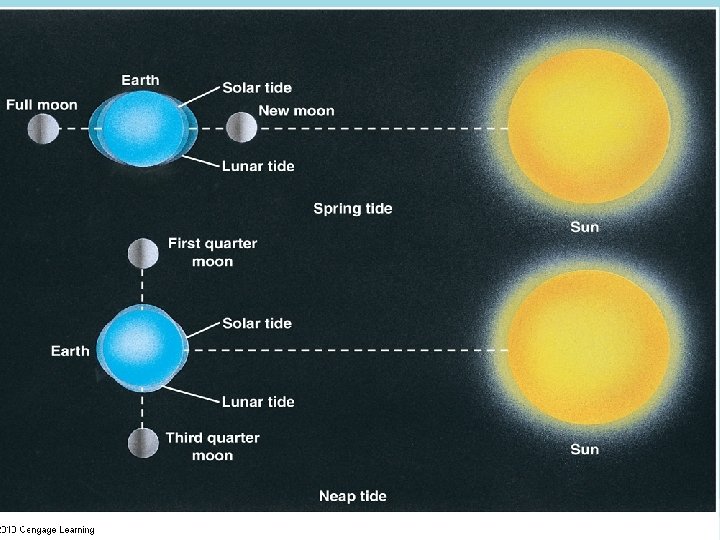
Tides • Tides: periodic changes in water level occurring along coastlines • Why tides occur – tides result from the gravitational pull of the moon and the sun – though smaller, the moon is closer to earth, so its gravitational pull is greater – water moves toward the moon, forming a bulge at the point directly under it – the centrifugal force opposite the moon forms another bulge – areas of low water form between bulges
Tides • Spring and neap tides – during spring tides, the times of highest and lowest tides, the earth, moon and sun are in a line and act together creating highest and lowest tides – when the sun and moon are at right angles, the sun’s pull offsets the moon’s, resulting in neap tides, which have the smallest change between high and low tide
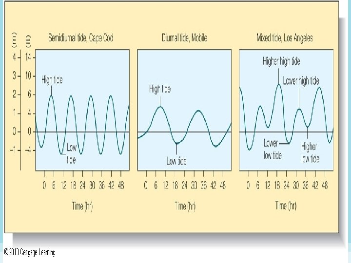
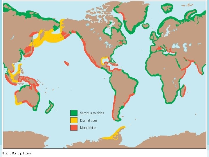
Tides • Tidal range – diurnal tide: one high tide and one low tide each day – semidiurnal tide: two high tides and two low tides each day (most common) • mixed semidiurnal tide: high and low tides are at different levels – flood tides are rising; ebb tides are falling – tidal currents are associated with tidal cycle – slack water occurs during the change of tides
Climate and the Ocean is a great modifier of temperature Hydrologic cycle • Convection, evaporation, and precipitation
Weather Front - when cold air mass collides with a warm air mass • Fronts are marked by stormy weather
Monsoons Seasonal wind pattern changes caused by heating or cooling on the continents • Summers - significant rainfall and winters very little Common on the west coast of India and in Southeast Asia
Cyclones • Large rotating storm systems of low-pressure air Forms over warm oceans near Equator • Typhoons – Pacific Ocean • Hurricanes – Atlantic Ocean Strong rotating winds • At least 74 miles per hour • Thunder and Lightning • Winds rotate in a counterclockwise direction around a central, calm eye
When it moves over land (or cold water) the storm begins to weaken quickly • Storm is fueled by warm water Average 100 cyclones worldwide each year
• Weather symbol for a hurricane is: • Marine flags that warn of a hurricane
Hurricane Structure Eye – relatively calm • roughly 20 to 30 miles wide Smaller the eye – stronger the winds Right side generally has the fastest winds Left side usually has the most rain
Hurricane Classification 5 categories based on current maximum wind speed Saffir-Simpson Hurricane Scale • Category 1 – Winds 74 -95 mph • Category 2 – Winds 96 -11 mph • Category 3 – Winds 111 -130 mph • Category 4 – Winds 131 -155 mph • Category 5 – Winds over 155 mph – Very rare, status for a short time
Storm Surges Becoming more dangerous due to increase in coastal population
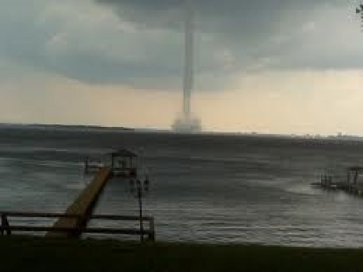
Waterspouts • • • Tornado over water May carry water as high as 328 ft Very short-lived Not particularly dangerous Most often occur during the summer months • Florida Keys have the most in the U. S.