Cape Meares Loop Landslide Western Federal Lands Highway


 # of Stream Crossings Forested Land Impacts")

 Constructability Concerns Potential")


- Slides: 23
Cape Meares Loop Landslide Western Federal Lands Highway Division Alternative Analysis
DOGAMI MAPPED LANDSLIDE TERRAIN LANDSLIDE FEATURES
Recent History • Board of County Commissioners closed the road in January 2013 • Federal Highways Emergency Relief (FWHA ER) program $250, 000 alternative study 2014 • FHWA ER approved $2. 5 million for maintenance project. Board convinced FHWA that a new road realignment is in County’s best interest • 2014 County applies and receives $4 million in FLAP funding; County match 10. 27% • Western Federal Lands Highway Division of Federal Highways (WFLHD) is leading the design for new route around active landslide - June 2015 • 2016 County applies and receives additional $6 million in FLAP funding; County match 10. 27% • February 2017 Alternative Analysis is complete and sharing information with our community.
Roadway Alternatives Preliminary Work 2014 OTAK/Landslide Technologies
GEOTECHNICAL EXPLORATIONS - 20
DEEP PATCH
TRENCH DRAINS HORIZONTAL DRAINS DRAINAGE MEASURES
BUTTRESS EARTHWORK - BUTTRESSES
Alternatives Analysis – Risk Matrix
Western Federal Lands Highway Division Vancouver, WA Leads Design Efforts – Initiated Spring 2016 Tillamook County leading Public Outreach efforts
Alternative Analysis
Preliminary Studies completed • • • Geotechnical Investigation Site Reconnaissance Wetland Water Determination Hydraulics Study Biological Survey Cultural Resource Surveys
Stakeholder Outreach • • • Oceanside Water District Stimson Lumber Company Adjacent Property Owner Consultation with Grand Ronde and Siletz Tribes Oregon State Parks United States Fish and Wildlife Service National Marine Fisheries Service Department of Environmental Quality Oregon Division of State Lands
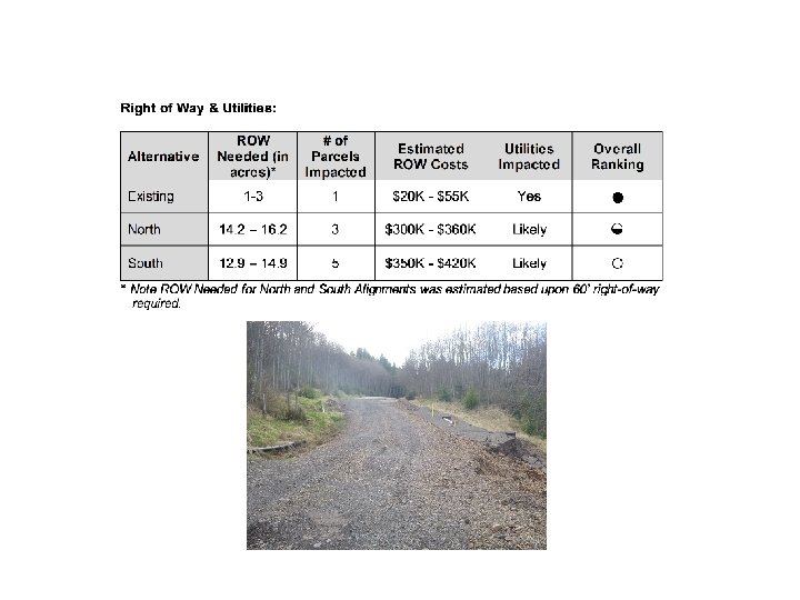
Alternatives Screening Results ● A full circle represents that the alignment best meets the criteria, and ranks the highest among the alternatives ◒ A half circle represents that the alignment ranks second among the alternatives for the criteria. ○ A circle represents that the alignment ranks last among the alternatives for the criteria.
Environmental Resources: Wetland Impacts (range in acres) # of Stream Crossings Forested Land Impacts (in acres) Overall Ranking Existing 0. 0002 to 0. 045 6 0. 825 ● North 0. 011 to 0. 064 11 17. 66 ◒ South 0. 330 to 0. 163 17 15. 74 ○ Alternative
B 16 -02 Core Box 2 – 57. 0 to 76. 1 feet B 16 -08 Core Box 3 – 58. 3 to 67. 2 feet
Project Risks: Traveling Public Safety Life Cycle Risk (Longevity of Solution) Constructability Concerns Potential for Community Isolation Overall Ranking Existing High Medium High ○ North Low Low South Low Medium Low Alternative ● ◒
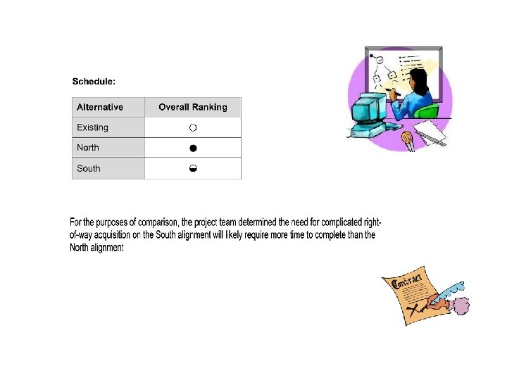
Overall Ranking OVERALL RANKING Alternativ e Cost Existing ○ North ◒ ● South Env. Impacts ROW/ Utilities ● ◒ ○ ○ Geotech Risk Schedul e Overall ○ ○ ● ◒ ● ◒
Cape Meares Road Relocation Environmental Review Schedule Federal Highway Administration Tillamook County Scoping and Early Coordination Mar - Aug Environmental Studies and Reports Mar - Nov Alternatives Screening Oct - Dec Draft EA Feb - Oct 2017 EA Review Nov 2017 Project Kickoff Meeting Website Mar 15 2016 -2018 Mar Preferred Alternative Selected for EA Review (30 day review) Jan 20 Apr 15 Apr Public Notice May Jun Jul Aug Sep Oct Nov Dec Public Notice Section 106 May 2016 Complete Jul 2016 2017 Nov 2017 Feb 2018 Jan-Feb 2018 ESA Public Mtg Complete (optional) Aug 2017 NEPA Complete Nov 2017 Issue FONSI Feb 2018
Next Steps: The project team is recommending moving forward with additional analysis in the Environmental Assessment of the North alignment and the No Build alternative. The Existing alignment ranked least and has been dismissed. While the Existing alignment alternative meets the purpose and need of the project, it has been determined not reasonable because of risk related to geotechnical stability as well as cost. The South alignment meets the purpose and need of the project, but the impacts were similar or slightly more (such as costs) when compared to the North alignment. Once the NEPA process is completed in February 2018, move towards 70% design. Construction scheduled for 2020.
Kevin J. Gray, PE Project Manager FHWA - Western Federal Lands Highway Division 610 East 5 th Street Vancouver, WA 98661 D 360 -619 -7652 M 503 -221 -0005 kevin. j. gray@dot. gov Liane M. Welch, PE Director Tillamook County Public Works Road Department 503 Marolf Loop Road Tillamook, OR 97141 503 -842 -3419 lwelch@co. tillamook. or. us