Aristotle University of Thessaloniki Department of Geodesy and
- Slides: 106
Aristotle University of Thessaloniki – Department of Geodesy and Surveying Aristotle University of Thessaloniki School of Rural & Surveying Engineering Department of Geodesy & Surveying 3 rd Semester Signals and Spectral Methods in Geoinformatics Lecture Presentations prepared by Prof. Athanasios Dermanis A. Dermanis Signals and Spectral Methods in Geoinformatics
Aristotle University of Thessaloniki – Department of Geodesy and Surveying Lecture 1: Introduction A. Dermanis Signals and Spectral Methods in Geoinformatics
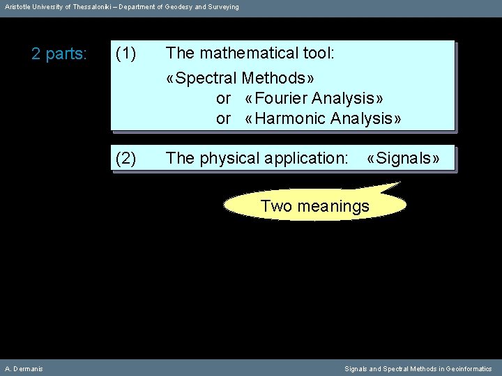
Aristotle University of Thessaloniki – Department of Geodesy and Surveying 2 parts: (1) The mathematical tool: «Spectral Methods» or «Fourier Analysis» or «Harmonic Analysis» (2) The physical application: «Signals» Two meanings A. Dermanis Signals and Spectral Methods in Geoinformatics
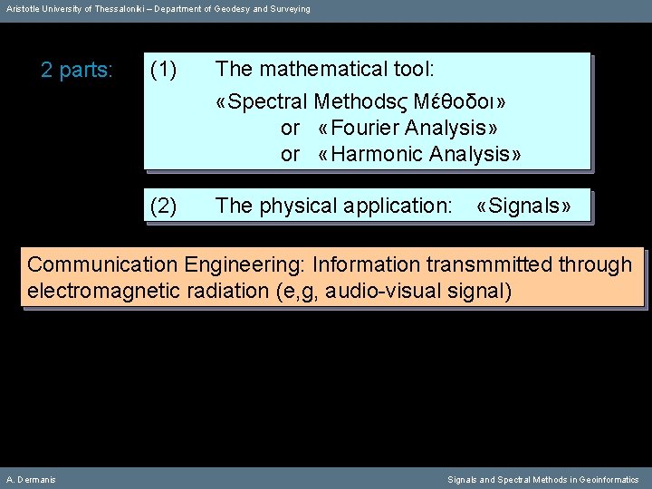
Aristotle University of Thessaloniki – Department of Geodesy and Surveying 2 parts: (1) The mathematical tool: «Spectral Methodsς Μέθοδοι» or «Fourier Analysis» or «Harmonic Analysis» (2) The physical application: «Signals» Communication Engineering: Information transmmitted through electromagnetic radiation (e, g, audio-visual signal) A. Dermanis Signals and Spectral Methods in Geoinformatics
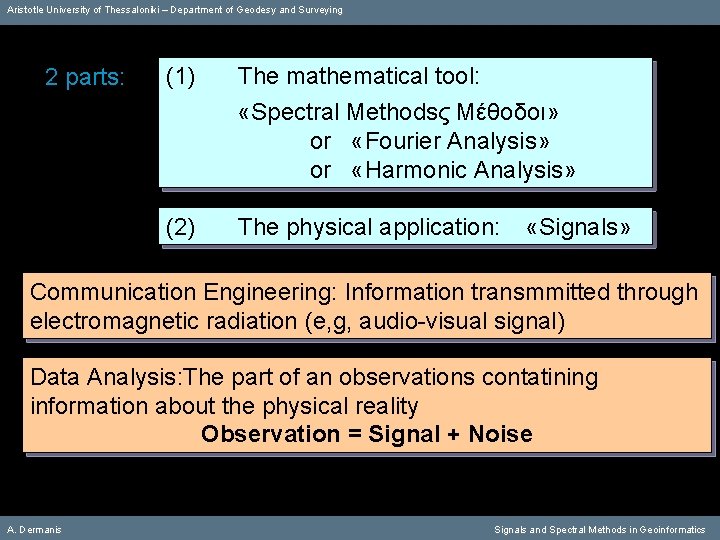
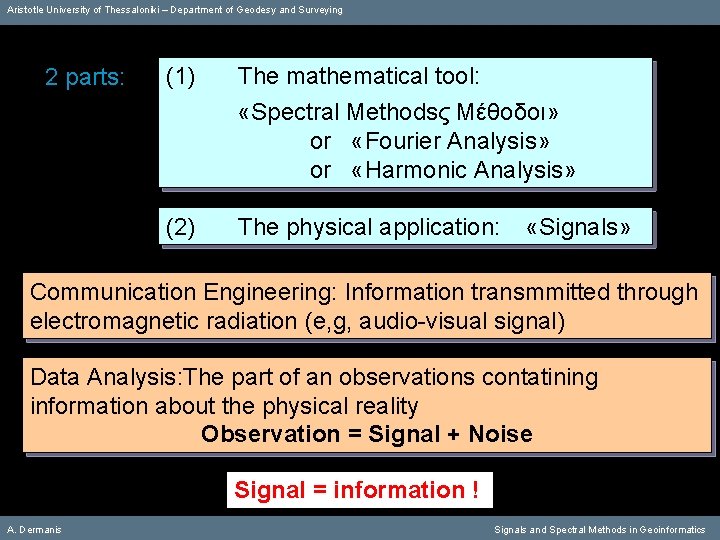
Aristotle University of Thessaloniki – Department of Geodesy and Surveying 2 parts: (1) The mathematical tool: «Spectral Methodsς Μέθοδοι» or «Fourier Analysis» or «Harmonic Analysis» (2) The physical application: «Signals» Communication Engineering: Information transmmitted through electromagnetic radiation (e, g, audio-visual signal) Data Analysis: The part of an observations contatining information about the physical reality Observation = Signal + Noise A. Dermanis Signals and Spectral Methods in Geoinformatics
Aristotle University of Thessaloniki – Department of Geodesy and Surveying 2 parts: (1) The mathematical tool: «Spectral Methodsς Μέθοδοι» or «Fourier Analysis» or «Harmonic Analysis» (2) The physical application: «Signals» Communication Engineering: Information transmmitted through electromagnetic radiation (e, g, audio-visual signal) Data Analysis: The part of an observations contatining information about the physical reality Observation = Signal + Noise Signal = information ! A. Dermanis Signals and Spectral Methods in Geoinformatics
Aristotle University of Thessaloniki – Department of Geodesy and Surveying 2 parts: A. Dermanis (1) The mathematical tool: «Spectral Methodsς Μέθοδοι» or «Fourier Analysis» or «Harmonic Analysis» (2) The physical application: «Signals» Signals and Spectral Methods in Geoinformatics
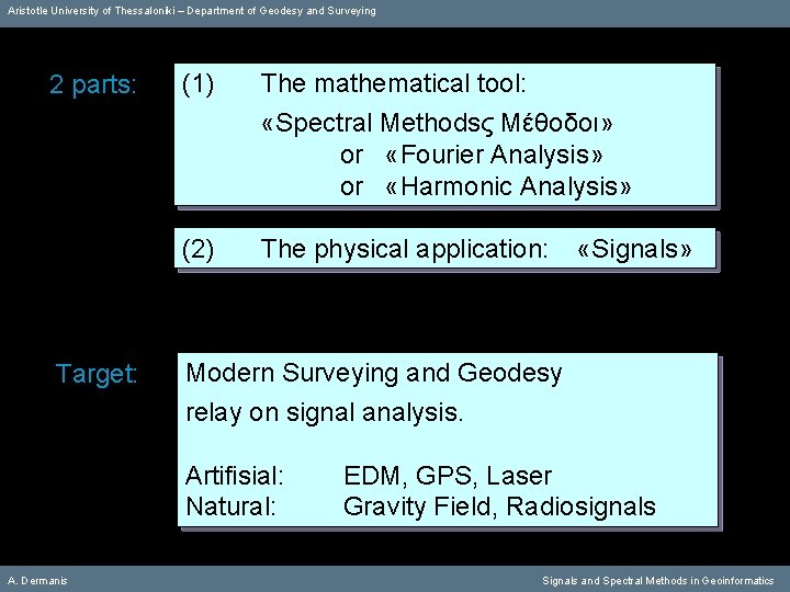
Aristotle University of Thessaloniki – Department of Geodesy and Surveying 2 parts: Target: (1) The mathematical tool: «Spectral Methodsς Μέθοδοι» or «Fourier Analysis» or «Harmonic Analysis» (2) The physical application: Modern Surveying and Geodesy relay on signal analysis. Artifisial: Natural: A. Dermanis «Signals» ΕDM, GPS, Laser Gravity Field, Radiosignals Signals and Spectral Methods in Geoinformatics
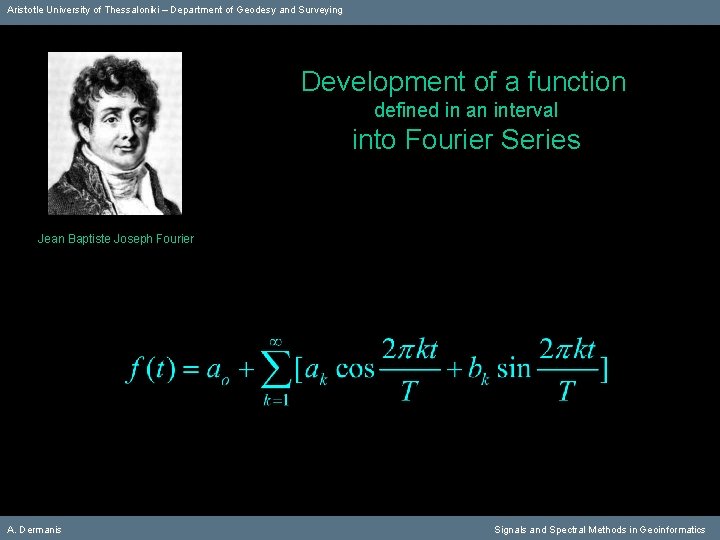
Aristotle University of Thessaloniki – Department of Geodesy and Surveying Development of a function defined in an interval into Fourier Series Jean Baptiste Joseph Fourier A. Dermanis Signals and Spectral Methods in Geoinformatics
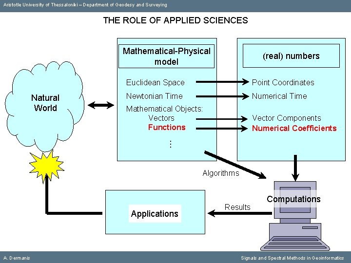
Aristotle University of Thessaloniki – Department of Geodesy and Surveying THE ROLE OF APPLIED SCIENCES Mathematical-Physical model Euclidean Space Point Coordinates Newtonian Time Numerical Time Mathematical Objects: Vectors Functions Vector Components Numerical Coefficients Natural World (real) numbers Algorithms Applications A. Dermanis Results Computations Signals and Spectral Methods in Geoinformatics
Aristotle University of Thessaloniki – Department of Geodesy and Surveying TURNING MATHEMATICAL OBJECTS INTO NUMBERS mathematical objects A. Dermanis numbers Signals and Spectral Methods in Geoinformatics
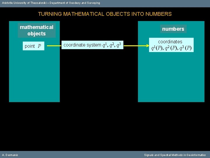
Aristotle University of Thessaloniki – Department of Geodesy and Surveying TURNING MATHEMATICAL OBJECTS INTO NUMBERS mathematical objects point Ρ A. Dermanis numbers coordinate system q 1, q 2, q 3 coordinates q 1(Ρ), q 2 (Ρ), q 3 (Ρ) Signals and Spectral Methods in Geoinformatics
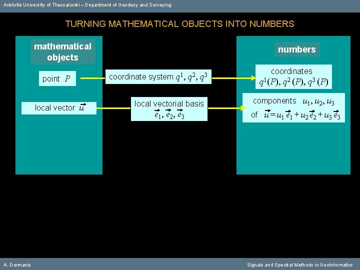
Aristotle University of Thessaloniki – Department of Geodesy and Surveying TURNING MATHEMATICAL OBJECTS INTO NUMBERS mathematical objects point Ρ local vector u A. Dermanis numbers coordinate system q 1, q 2, q 3 coordinates q 1(Ρ), q 2 (Ρ), q 3 (Ρ) local vectorial basis components u 1, u 2, u 3 e 1 , e 2 , e 3 of u = u 1 e 1 + u 2 e 2 + u 3 e 3 Signals and Spectral Methods in Geoinformatics
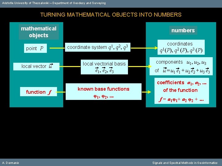
Aristotle University of Thessaloniki – Department of Geodesy and Surveying TURNING MATHEMATICAL OBJECTS INTO NUMBERS mathematical objects point Ρ local vector u function f A. Dermanis numbers coordinate system q 1, q 2, q 3 coordinates q 1(Ρ), q 2 (Ρ), q 3 (Ρ) local vectorial basis components u 1, u 2, u 3 e 1 , e 2 , e 3 of u = u 1 e 1 + u 2 e 2 + u 3 e 3 known base functions φ1, φ2, . . . coefficients α 1, α 2, . . . of the function f = a 1φ1+ a 2 φ2 +. . . Signals and Spectral Methods in Geoinformatics
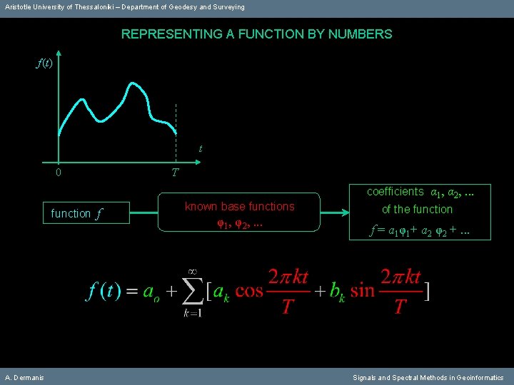
Aristotle University of Thessaloniki – Department of Geodesy and Surveying REPRESENTING A FUNCTION BY NUMBERS f (t) t 0 function f A. Dermanis Τ known base functions φ1, φ2, . . . coefficients α 1, α 2, . . . of the function f = a 1φ1+ a 2 φ2 +. . . Signals and Spectral Methods in Geoinformatics
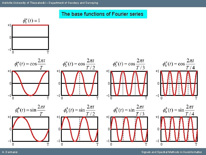
Aristotle University of Thessaloniki – Department of Geodesy and Surveying The base functions of Fourier series +1 0 – 1 0 Τ +1 +1 0 0 – 1 0 Τ – 1 +1 +1 0 0 – 1 0 A. Dermanis Τ – 1 0 Τ Signals and Spectral Methods in Geoinformatics
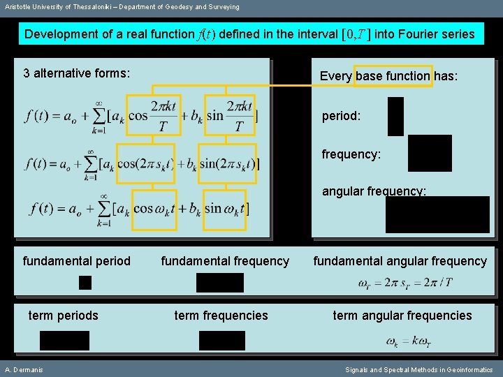
Aristotle University of Thessaloniki – Department of Geodesy and Surveying Development of a real function f(t) defined in the interval [0, T ] into Fourier series 3 alternative forms: Every base function has: period: frequency: angular frequency: fundamental period term periods A. Dermanis fundamental frequency fundamental angular frequency term frequencies term angular frequencies Signals and Spectral Methods in Geoinformatics
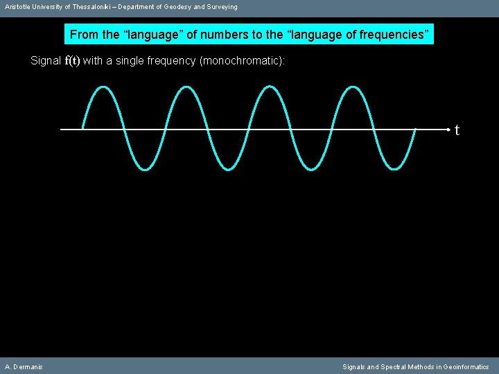
Aristotle University of Thessaloniki – Department of Geodesy and Surveying From the “language” of numbers to the “language of frequencies” Signal f(t) with a single frequency (monochromatic): t A. Dermanis Signals and Spectral Methods in Geoinformatics
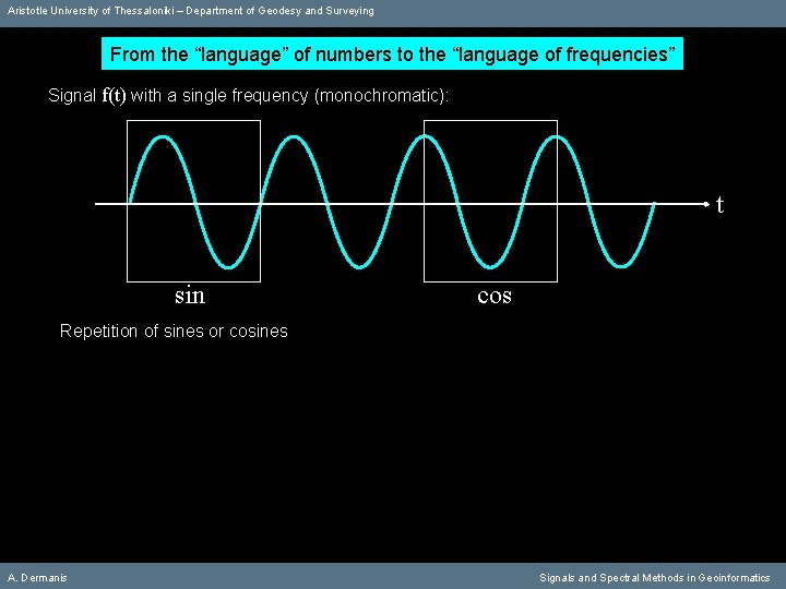
Aristotle University of Thessaloniki – Department of Geodesy and Surveying From the “language” of numbers to the “language of frequencies” Signal f(t) with a single frequency (monochromatic): t sin cos Repetition of sines or cosines A. Dermanis Signals and Spectral Methods in Geoinformatics
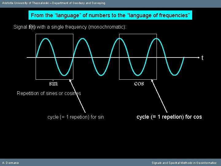
Aristotle University of Thessaloniki – Department of Geodesy and Surveying From the “language” of numbers to the “language of frequencies” Signal f(t) with a single frequency (monochromatic): t sin cos Repetition of sines or cosines cycle (= 1 repetion) for sin A. Dermanis cycle (= 1 repetion) for cos Signals and Spectral Methods in Geoinformatics
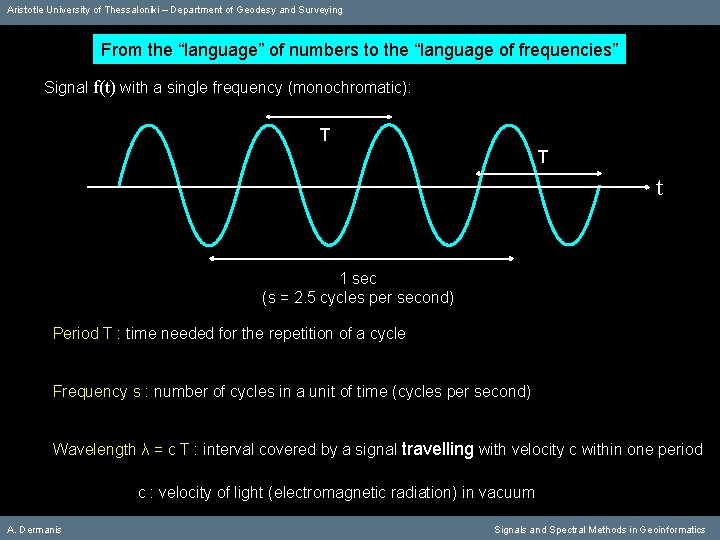
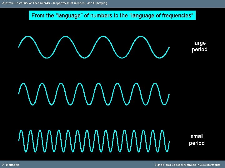
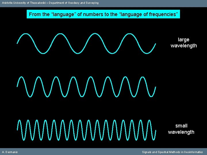
Aristotle University of Thessaloniki – Department of Geodesy and Surveying From the “language” of numbers to the “language of frequencies” Signal f(t) with a single frequency (monochromatic): Τ Τ t 1 sec (s = 2. 5 cycles per second) Period Τ : time needed for the repetition of a cycle Frequency s : number of cycles in a unit of time (cycles per second) Wavelength λ = c T : interval covered by a signal travelling with velocity c within one period c : velocity of light (electromagnetic radiation) in vacuum A. Dermanis Signals and Spectral Methods in Geoinformatics
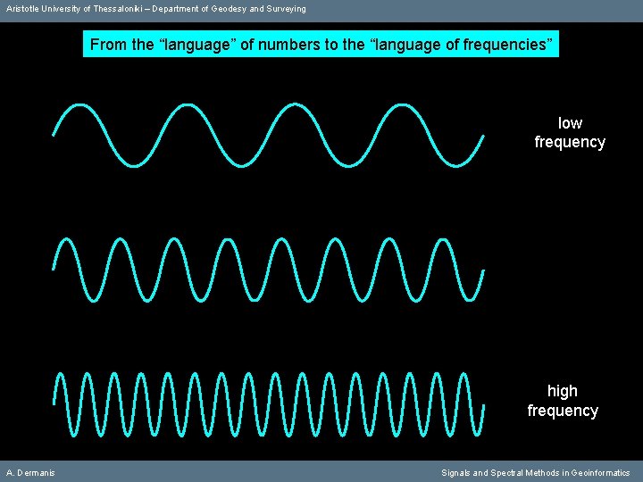
Aristotle University of Thessaloniki – Department of Geodesy and Surveying From the “language” of numbers to the “language of frequencies” low frequency high frequency A. Dermanis Signals and Spectral Methods in Geoinformatics
Aristotle University of Thessaloniki – Department of Geodesy and Surveying From the “language” of numbers to the “language of frequencies” large period small period A. Dermanis Signals and Spectral Methods in Geoinformatics
Aristotle University of Thessaloniki – Department of Geodesy and Surveying From the “language” of numbers to the “language of frequencies” large wavelength small wavelength A. Dermanis Signals and Spectral Methods in Geoinformatics
Aristotle University of Thessaloniki – Department of Geodesy and Surveying Three equivalent names: «Spectral Methods» «Fourier Analysis» «Harmonic Analysis» Fourier Analysis Fourier has been the first to realize that “ALL” functions can be expresses through linear combinations of trigonometric functions A. Dermanis Signals and Spectral Methods in Geoinformatics
Aristotle University of Thessaloniki – Department of Geodesy and Surveying Three equivalent names: «Spectral Methods» «Fourier Analysis» «Harmonic Analysis» Spectral Methods in relation to the spectrum of light (visible part of the electromagnetic radiation) or more generally in relation to the spectrum of electromagnetic radiation A. Dermanis Signals and Spectral Methods in Geoinformatics
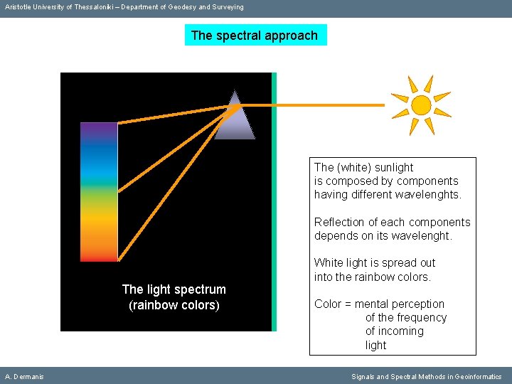
Aristotle University of Thessaloniki – Department of Geodesy and Surveying The spectral approach The (white) sunlight is composed by components having different wavelenghts. Reflection of each components depends on its wavelenght. The light spectrum (rainbow colors) A. Dermanis White light is spread out into the rainbow colors. Color = mental perception of the frequency of incoming light Signals and Spectral Methods in Geoinformatics
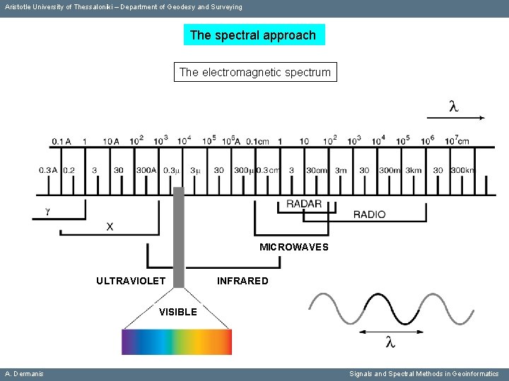
Aristotle University of Thessaloniki – Department of Geodesy and Surveying The spectral approach The electromagnetic spectrum MICROWAVES ULTRAVIOLET INFRARED VISIBLE A. Dermanis Signals and Spectral Methods in Geoinformatics
Aristotle University of Thessaloniki – Department of Geodesy and Surveying Three equivalent names: «Spectral Methods» «Fourier Analysis» «Harmonic Analysis» Harmonic Analysis in relation to the role of frequencies in the harmony of musical sounds A. Dermanis Signals and Spectral Methods in Geoinformatics
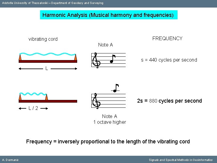
Aristotle University of Thessaloniki – Department of Geodesy and Surveying Harmonic Analysis (Musical harmony and frequencies) FREQUENCY vibrating cord Note Α ♪ s = 440 cycles per second L ♪ 2 s = 880 cycles per second L/2 Note Α 1 octave higher Frequency = inversely proportional to the length of the vibrating cord A. Dermanis Signals and Spectral Methods in Geoinformatics
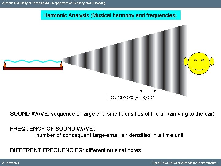
Aristotle University of Thessaloniki – Department of Geodesy and Surveying Harmonic Analysis (Musical harmony and frequencies) 1 sound wave (= 1 cycle) SOUND WAVE: sequence of large and small densities of the air (arriving to the ear) FREQUENCY OF SOUND WAVE: number of consequent large-small air densities in a time unit DIFFERENT FREQUENCIES: different musical notes A. Dermanis Signals and Spectral Methods in Geoinformatics
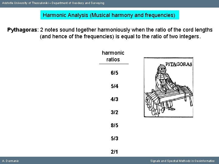
Aristotle University of Thessaloniki – Department of Geodesy and Surveying Harmonic Analysis (Musical harmony and frequencies) Pythagoras: 2 notes sound together harmoniously when the ratio of the cord lengths (and hence of the frequencies) is equal to the ratio of two integers. harmonic ratios 6/5 5/4 4/3 3/2 8/5 5/3 2/1 A. Dermanis Signals and Spectral Methods in Geoinformatics
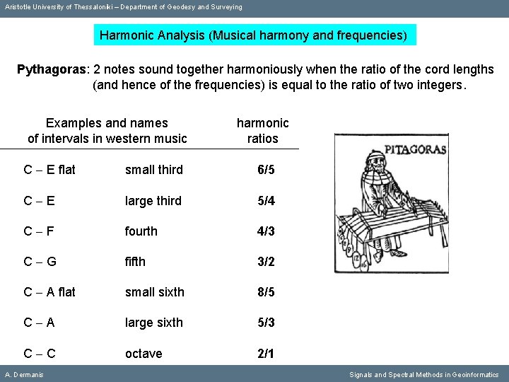
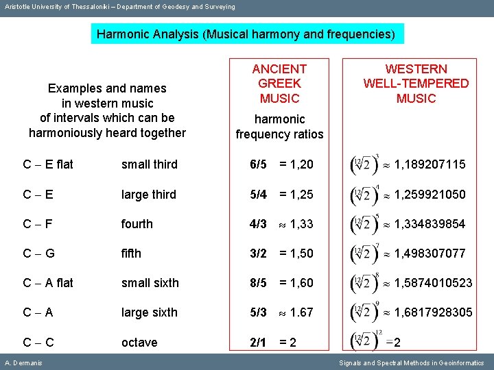
Aristotle University of Thessaloniki – Department of Geodesy and Surveying Harmonic Analysis (Musical harmony and frequencies) Pythagoras: 2 notes sound together harmoniously when the ratio of the cord lengths (and hence of the frequencies) is equal to the ratio of two integers. Examples and names of intervals in western music harmonic ratios C E flat small third 6/5 C E large third 5/4 C F fourth 4/3 C G fifth 3/2 C A flat small sixth 8/5 C A large sixth 5/3 C C octave 2/1 A. Dermanis Signals and Spectral Methods in Geoinformatics
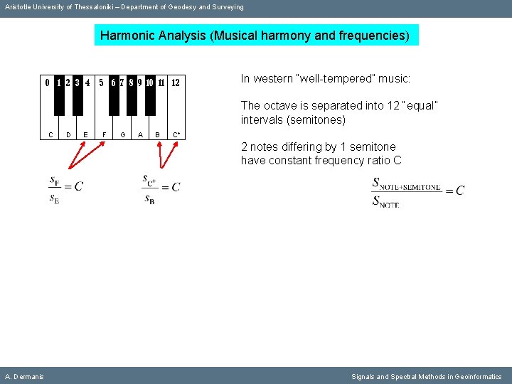
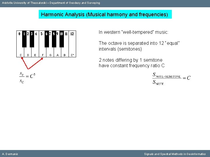
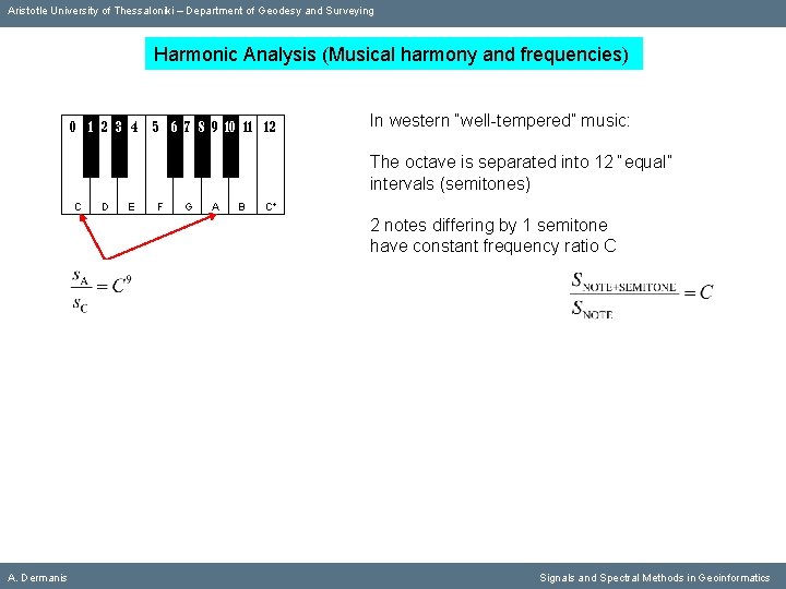
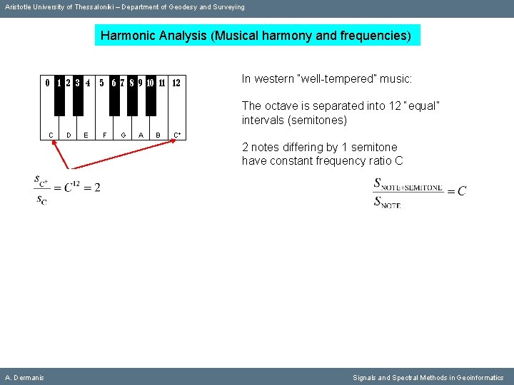
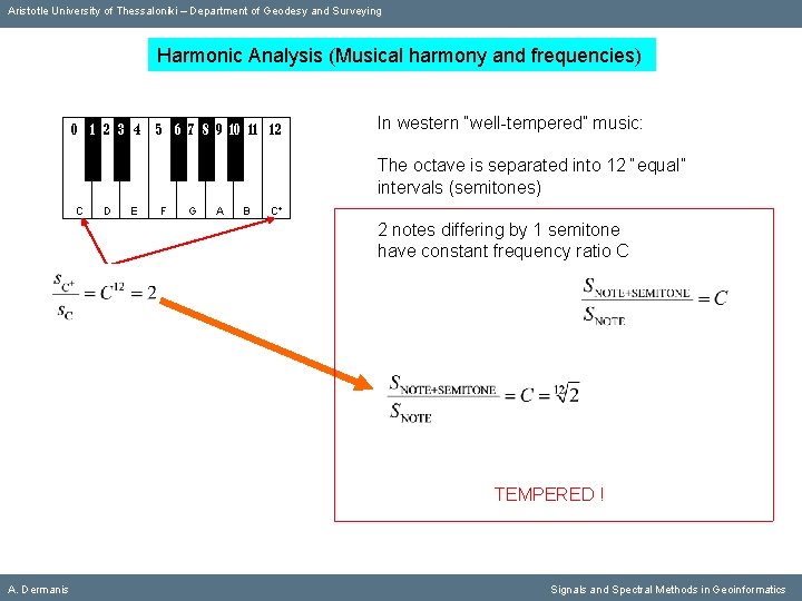
Aristotle University of Thessaloniki – Department of Geodesy and Surveying Harmonic Analysis (Musical harmony and frequencies) 0 1 2 3 4 5 6 7 8 9 10 11 12 In western “well-tempered” music: The octave is separated into 12 “equal” intervals (semitones) C D E F G A B C+ 2 notes differing by 1 semitone have constant frequency ratio C A. Dermanis Signals and Spectral Methods in Geoinformatics
Aristotle University of Thessaloniki – Department of Geodesy and Surveying Harmonic Analysis (Musical harmony and frequencies) 0 1 2 3 4 5 6 7 8 9 10 11 12 In western “well-tempered” music: The octave is separated into 12 “equal” intervals (semitones) C D E F G A B C+ 2 notes differing by 1 semitone have constant frequency ratio C A. Dermanis Signals and Spectral Methods in Geoinformatics
Aristotle University of Thessaloniki – Department of Geodesy and Surveying Harmonic Analysis (Musical harmony and frequencies) 0 1 2 3 4 5 6 7 8 9 10 11 12 In western “well-tempered” music: The octave is separated into 12 “equal” intervals (semitones) C D E F G A B C+ 2 notes differing by 1 semitone have constant frequency ratio C A. Dermanis Signals and Spectral Methods in Geoinformatics
Aristotle University of Thessaloniki – Department of Geodesy and Surveying Harmonic Analysis (Musical harmony and frequencies) 0 1 2 3 4 5 6 7 8 9 10 11 12 In western “well-tempered” music: The octave is separated into 12 “equal” intervals (semitones) C D E F G A B C+ 2 notes differing by 1 semitone have constant frequency ratio C A. Dermanis Signals and Spectral Methods in Geoinformatics
Aristotle University of Thessaloniki – Department of Geodesy and Surveying Harmonic Analysis (Musical harmony and frequencies) 0 1 2 3 4 5 6 7 8 9 10 11 12 In western “well-tempered” music: The octave is separated into 12 “equal” intervals (semitones) C D E F G A B C+ 2 notes differing by 1 semitone have constant frequency ratio C TEMPERED ! A. Dermanis Signals and Spectral Methods in Geoinformatics
Aristotle University of Thessaloniki – Department of Geodesy and Surveying Harmonic Analysis (Musical harmony and frequencies) Examples and names in western music of intervals which can be harmoniously heard together ANCIENT GREEK MUSIC WESTERN WELL-TEMPERED MUSIC harmonic frequency ratios C E flat small third 6/5 = 1, 20 1, 189207115 C E large third 5/4 = 1, 259921050 C F fourth 4/3 1, 334839854 C G fifth 3/2 = 1, 50 1, 498307077 C A flat small sixth 8/5 = 1, 60 1, 5874010523 C A large sixth 5/3 1. 67 1, 6817928305 C C octave 2/1 = 2 2 A. Dermanis Signals and Spectral Methods in Geoinformatics
Aristotle University of Thessaloniki – Department of Geodesy and Surveying Theory of Signals A. Dermanis Signals and Spectral Methods in Geoinformatics
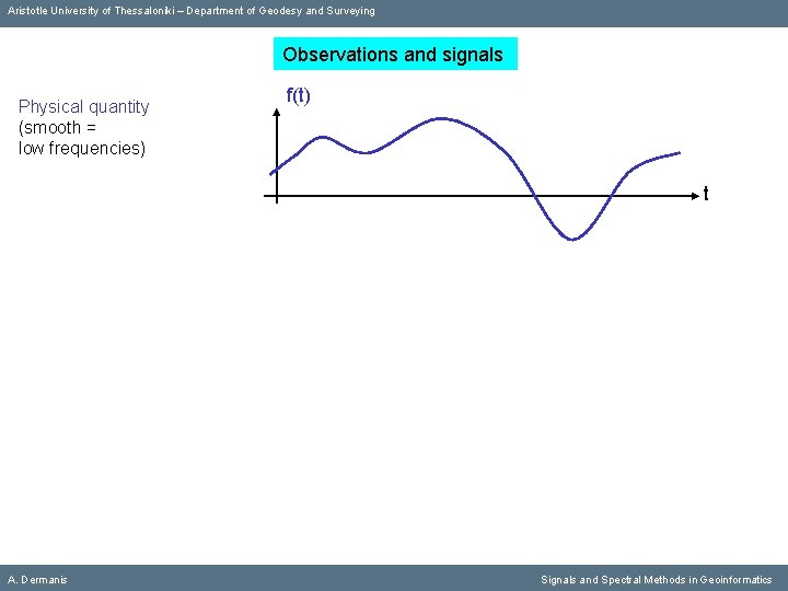
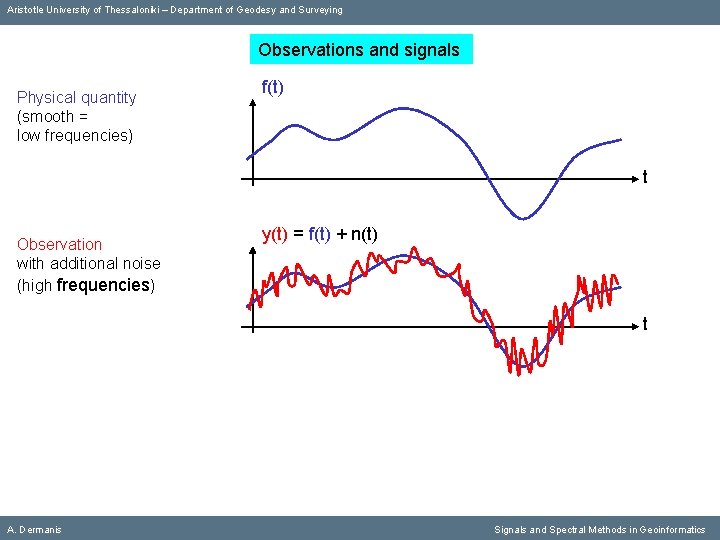
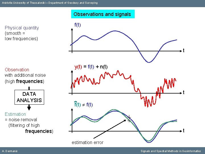
Aristotle University of Thessaloniki – Department of Geodesy and Surveying Observations and signals Physical quantity (smooth = low frequencies) f(t) t A. Dermanis Signals and Spectral Methods in Geoinformatics
Aristotle University of Thessaloniki – Department of Geodesy and Surveying Observations and signals Physical quantity (smooth = low frequencies) f(t) t Observation with additional noise (high frequencies) y(t) = f(t) + n(t) t A. Dermanis Signals and Spectral Methods in Geoinformatics
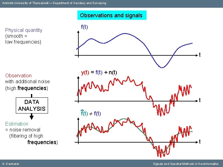
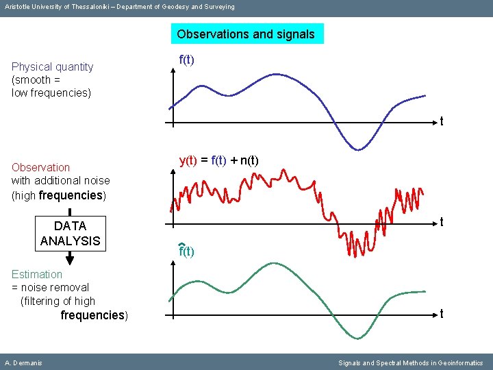
Aristotle University of Thessaloniki – Department of Geodesy and Surveying Observations and signals Physical quantity (smooth = low frequencies) f(t) t Observation with additional noise (high frequencies) DATA ANALYSIS Estimation = noise removal (filtering of high frequencies) A. Dermanis y(t) = f(t) + n(t) t f(t) t Signals and Spectral Methods in Geoinformatics
Aristotle University of Thessaloniki – Department of Geodesy and Surveying Observations and signals Physical quantity (smooth = low frequencies) f(t) t Observation with additional noise (high frequencies) DATA ANALYSIS Estimation = noise removal (filtering of high frequencies) A. Dermanis y(t) = f(t) + n(t) t f(t) t Signals and Spectral Methods in Geoinformatics
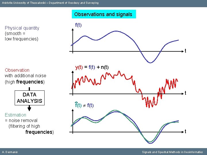
Aristotle University of Thessaloniki – Department of Geodesy and Surveying Observations and signals Physical quantity (smooth = low frequencies) f(t) t Observation with additional noise (high frequencies) DATA ANALYSIS Estimation = noise removal (filtering of high frequencies) A. Dermanis y(t) = f(t) + n(t) t f(t) t Signals and Spectral Methods in Geoinformatics
Aristotle University of Thessaloniki – Department of Geodesy and Surveying Observations and signals Physical quantity (smooth = low frequencies) f(t) t Observation with additional noise (high frequencies) DATA ANALYSIS y(t) = f(t) + n(t) t f(t) Estimation = noise removal (filtering of high t frequencies) estimation error A. Dermanis Signals and Spectral Methods in Geoinformatics
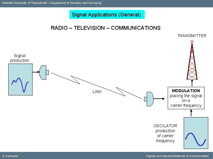
Aristotle University of Thessaloniki – Department of Geodesy and Surveying Signal Applications (General) RADIO – TELEVISION – COMMUNICATIONS TRANSMITTER Signal production LINK MODULATION placing the signal on a carrier frequency OSCILATOR production of carrier frequency A. Dermanis Signals and Spectral Methods in Geoinformatics
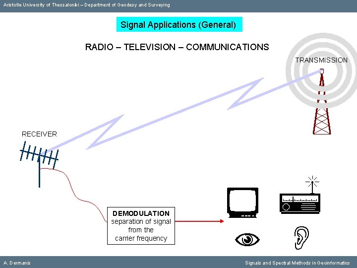
Aristotle University of Thessaloniki – Department of Geodesy and Surveying Signal Applications (General) RADIO – TELEVISION – COMMUNICATIONS TRANSMISSION RECEIVER DEMODULATION separation of signal from the carrier frequency A. Dermanis Signals and Spectral Methods in Geoinformatics
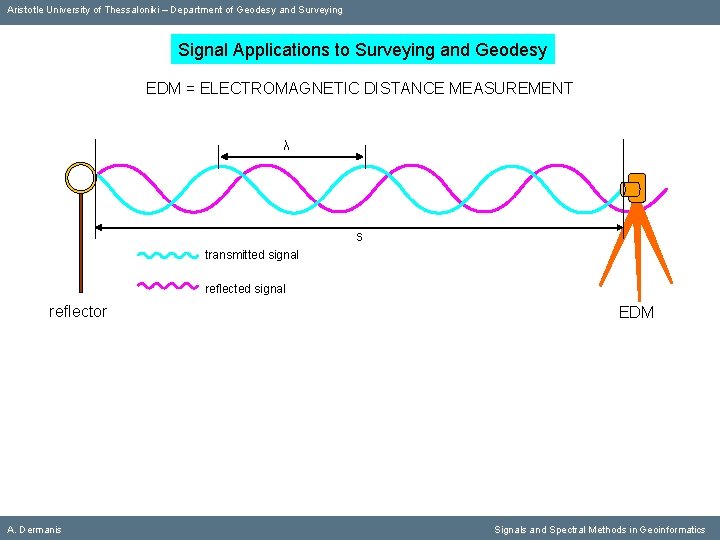
Aristotle University of Thessaloniki – Department of Geodesy and Surveying Signal Applications to Surveying and Geodesy ΕDM = ELECTROMAGNETIC DISTANCE MEASUREMENT λ s transmitted signal reflector A. Dermanis EDM Signals and Spectral Methods in Geoinformatics
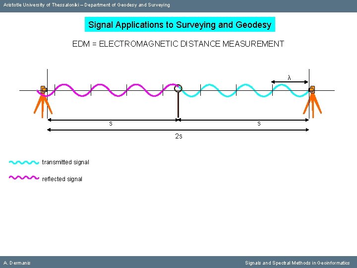
Aristotle University of Thessaloniki – Department of Geodesy and Surveying Signal Applications to Surveying and Geodesy ΕDM = ELECTROMAGNETIC DISTANCE MEASUREMENT λ s s 2 s transmitted signal reflected signal A. Dermanis Signals and Spectral Methods in Geoinformatics
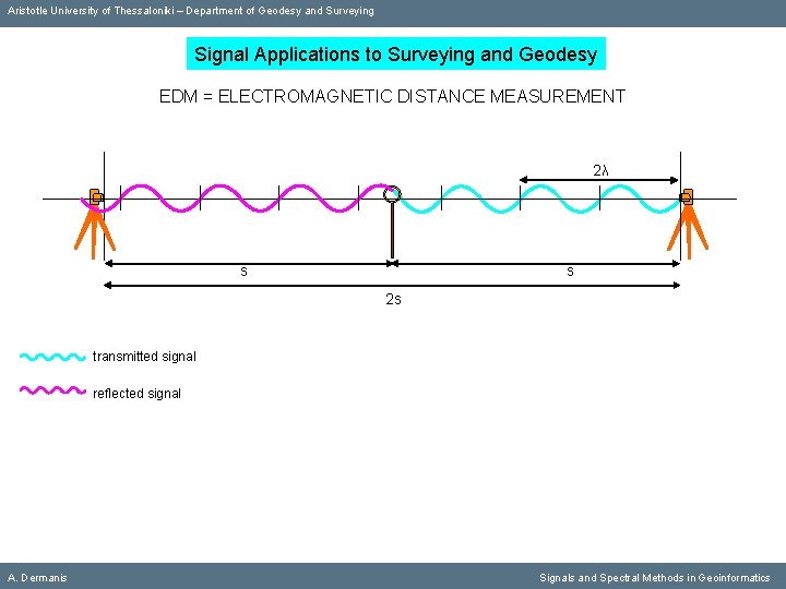
Aristotle University of Thessaloniki – Department of Geodesy and Surveying Signal Applications to Surveying and Geodesy ΕDM = ELECTROMAGNETIC DISTANCE MEASUREMENT 2λ s s 2 s transmitted signal reflected signal A. Dermanis Signals and Spectral Methods in Geoinformatics
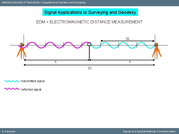
Aristotle University of Thessaloniki – Department of Geodesy and Surveying Signal Applications to Surveying and Geodesy ΕDM = ELECTROMAGNETIC DISTANCE MEASUREMENT 3λ s s 2 s transmitted signal reflected signal A. Dermanis Signals and Spectral Methods in Geoinformatics
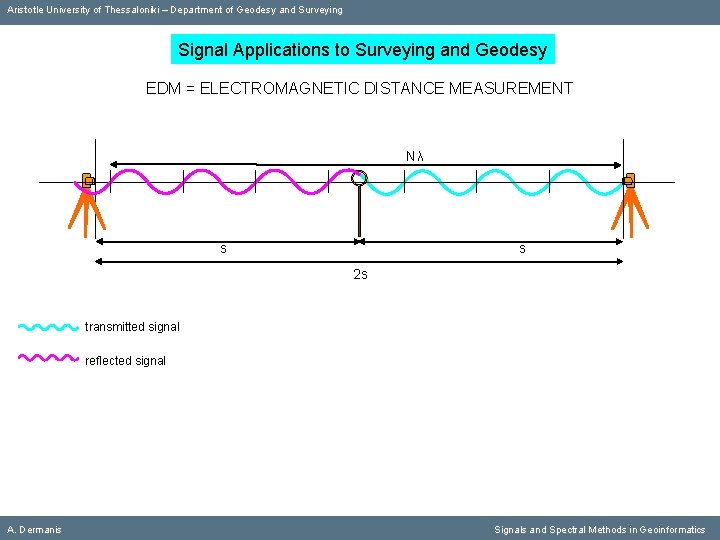
Aristotle University of Thessaloniki – Department of Geodesy and Surveying Signal Applications to Surveying and Geodesy ΕDM = ELECTROMAGNETIC DISTANCE MEASUREMENT Nλ s s 2 s transmitted signal reflected signal A. Dermanis Signals and Spectral Methods in Geoinformatics
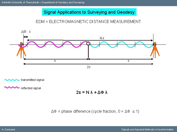
Aristotle University of Thessaloniki – Department of Geodesy and Surveying Signal Applications to Surveying and Geodesy ΕDM = ELECTROMAGNETIC DISTANCE MEASUREMENT ΔΦ λ Nλ s s 2 s transmitted signal reflected signal 2 s = N λ + ΔΦ λ ΔΦ = phase difference (cycle fraction, 0 < ΔΦ 1) A. Dermanis Signals and Spectral Methods in Geoinformatics
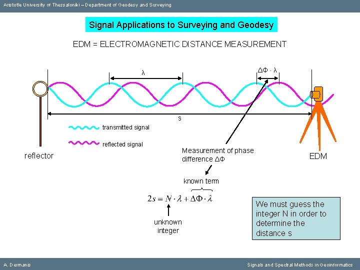
Aristotle University of Thessaloniki – Department of Geodesy and Surveying Signal Applications to Surveying and Geodesy ΕDM = ELECTROMAGNETIC DISTANCE MEASUREMENT ΔΦ λ λ s transmitted signal reflected signal Measurement of phase difference ΔΦ reflector EDM known term unknown integer A. Dermanis We must guess the integer Ν in order to determine the distance s Signals and Spectral Methods in Geoinformatics
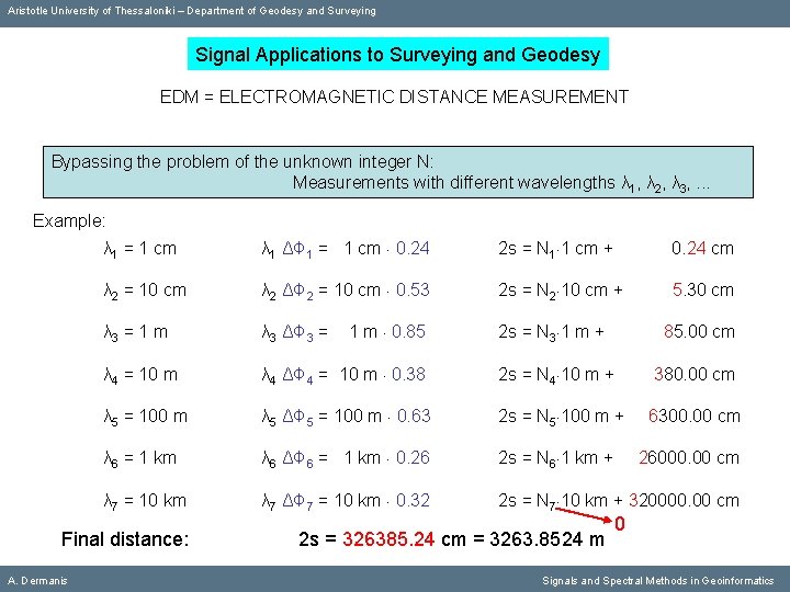
Aristotle University of Thessaloniki – Department of Geodesy and Surveying Signal Applications to Surveying and Geodesy ΕDM = ELECTROMAGNETIC DISTANCE MEASUREMENT Bypassing the problem of the unknown integer Ν: Measurements with different wavelengths λ 1, λ 2, λ 3, . . . Example: λ 1 = 1 cm λ 1 ΔΦ 1 = 1 cm 0. 24 2 s = Ν 1 1 cm + 0. 24 cm λ 2 = 10 cm λ 2 ΔΦ 2 = 10 cm 0. 53 2 s = Ν 2 10 cm + 5. 30 cm λ 3 = 1 m λ 3 ΔΦ 3 = λ 4 = 10 m 2 s = Ν 3 1 m + 85. 00 cm λ 4 ΔΦ 4 = 10 m 0. 38 2 s = Ν 4 10 m + 380. 00 cm λ 5 = 100 m λ 5 ΔΦ 5 = 100 m 0. 63 2 s = Ν 5 100 m + 6300. 00 cm λ 6 = 1 km λ 6 ΔΦ 6 = 1 km 0. 26 2 s = Ν 6 1 km + λ 7 = 10 km λ 7 ΔΦ 7 = 10 km 0. 32 2 s = Ν 7 10 km + 320000. 00 cm Final distance: A. Dermanis 1 m 0. 85 2 s = 326385. 24 cm = 3263. 8524 m 26000. 00 cm 0 Signals and Spectral Methods in Geoinformatics
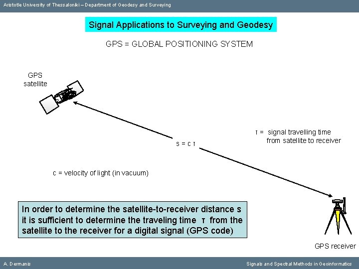
Aristotle University of Thessaloniki – Department of Geodesy and Surveying Signal Applications to Surveying and Geodesy GPS = GLOBAL POSITIONING SYSTEM GPS satellite s=cτ τ = signal travelling time from satellite to receiver c = velocity of light (in vacuum) In order to determine the satellite-to-receiver distance s it is sufficient to determine the traveling time τ from the satellite to the receiver for a digital signal (GPS code) GPS receiver A. Dermanis Signals and Spectral Methods in Geoinformatics
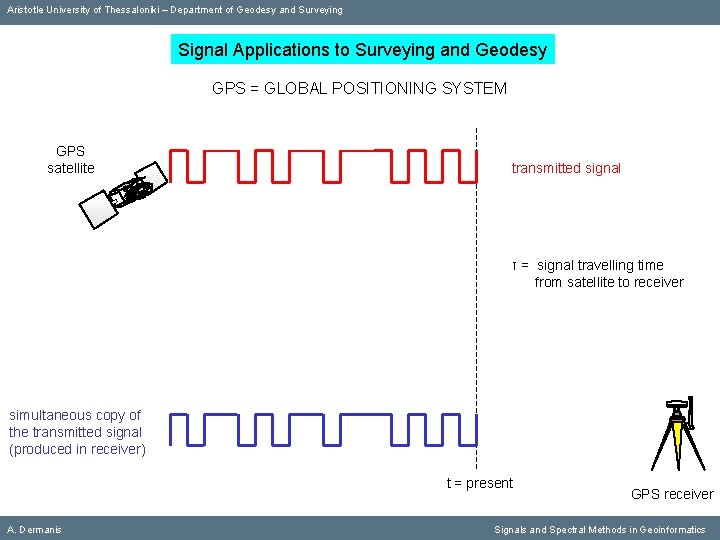
Aristotle University of Thessaloniki – Department of Geodesy and Surveying Signal Applications to Surveying and Geodesy GPS = GLOBAL POSITIONING SYSTEM GPS satellite transmitted signal τ = signal travelling time from satellite to receiver simultaneous copy of the transmitted signal (produced in receiver) t = present A. Dermanis GPS receiver Signals and Spectral Methods in Geoinformatics
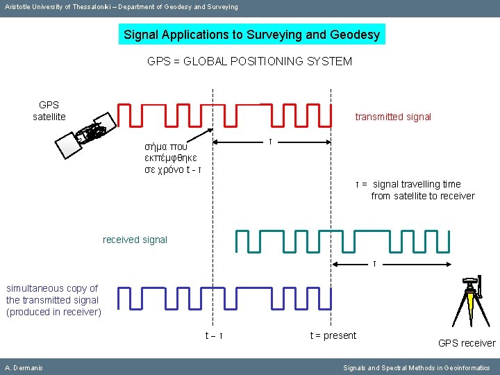
Aristotle University of Thessaloniki – Department of Geodesy and Surveying Signal Applications to Surveying and Geodesy GPS = GLOBAL POSITIONING SYSTEM GPS satellite transmitted signal τ σήμα που εκπέμφθηκε σε χρόνο t - τ τ = signal travelling time from satellite to receiver received signal τ simultaneous copy of the transmitted signal (produced in receiver) t τ A. Dermanis t = present GPS receiver Signals and Spectral Methods in Geoinformatics
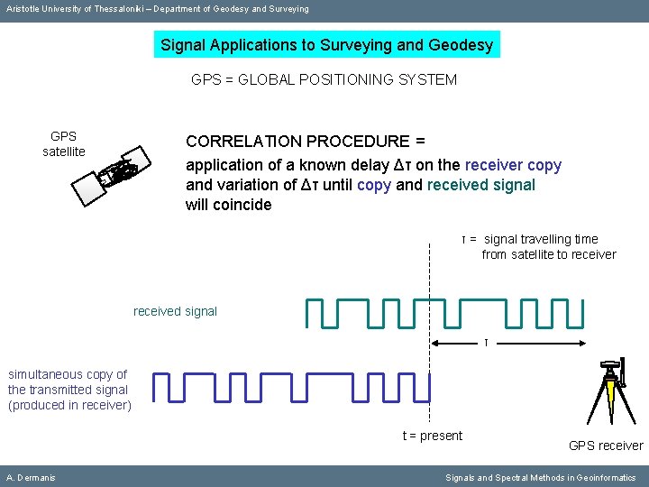
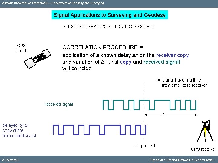
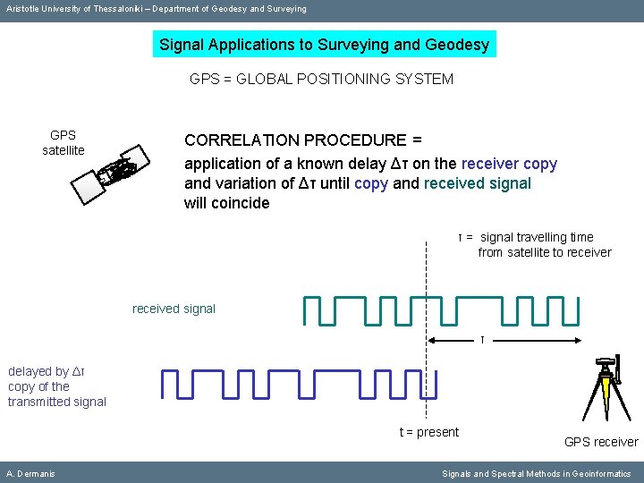
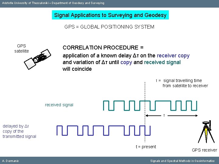
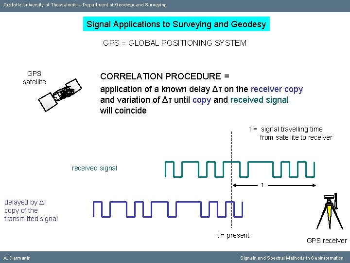
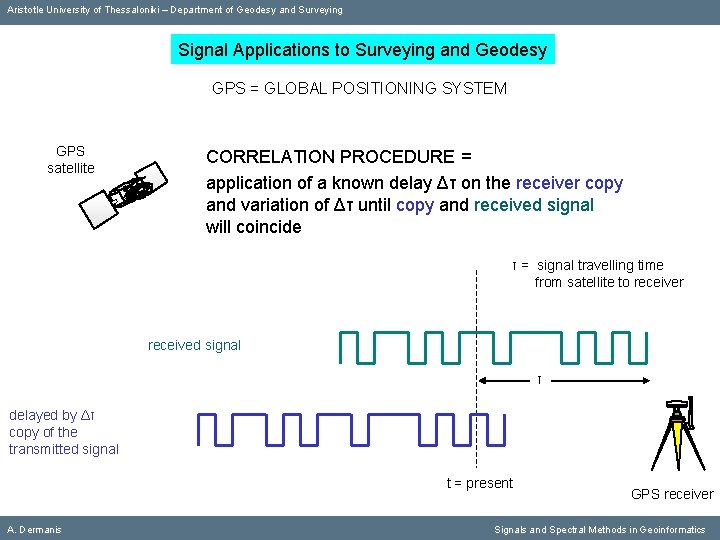
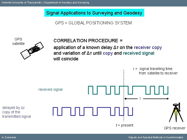
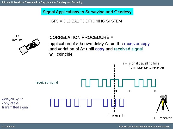
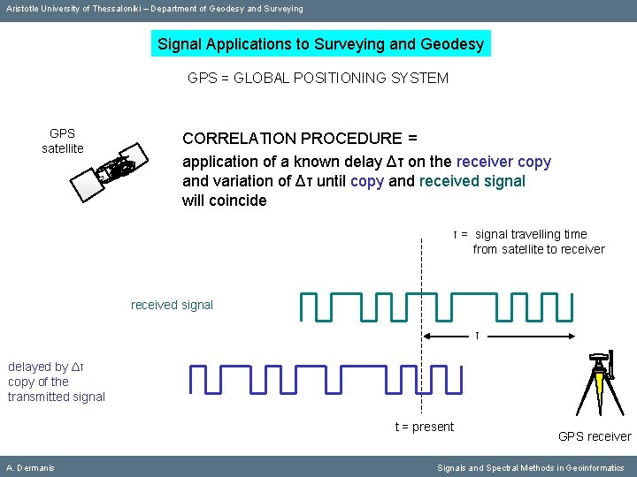
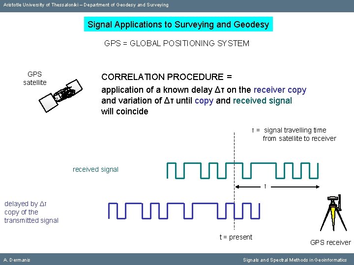
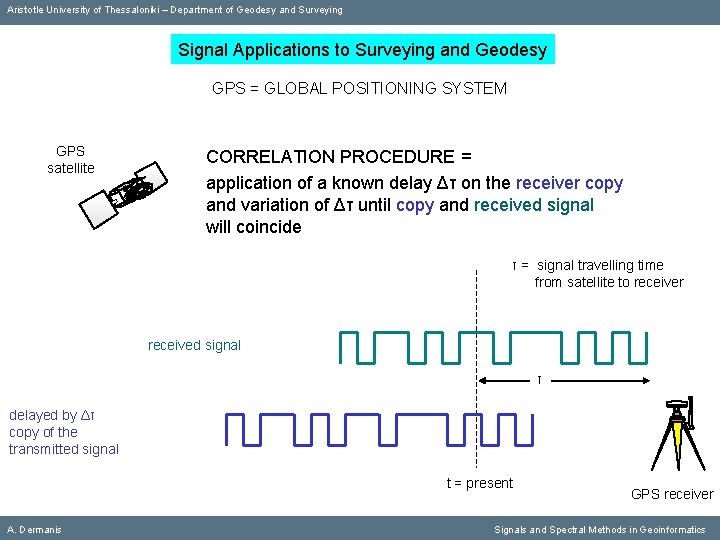
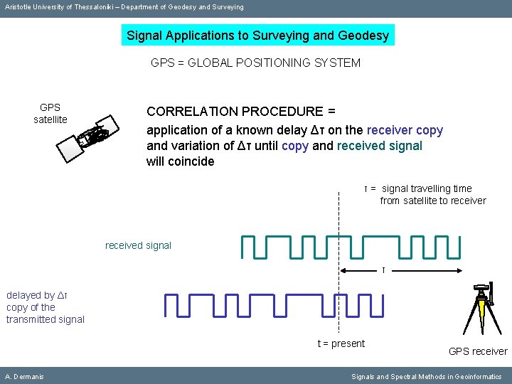
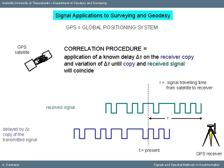
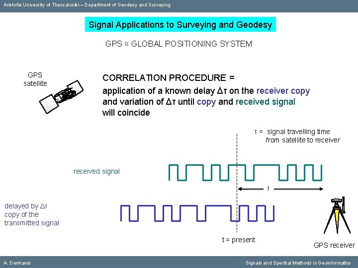
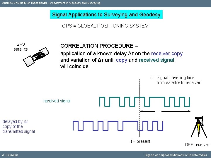
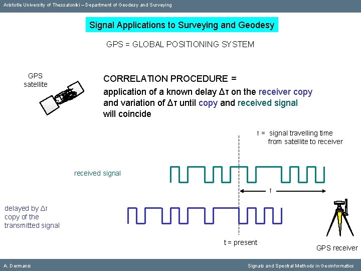
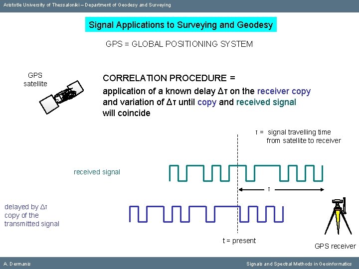
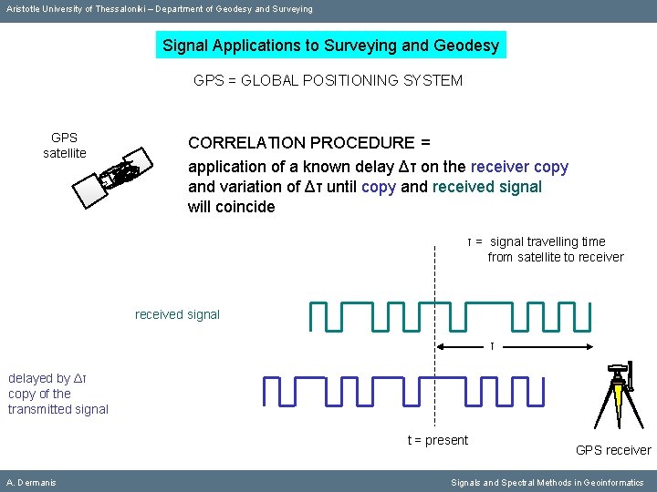
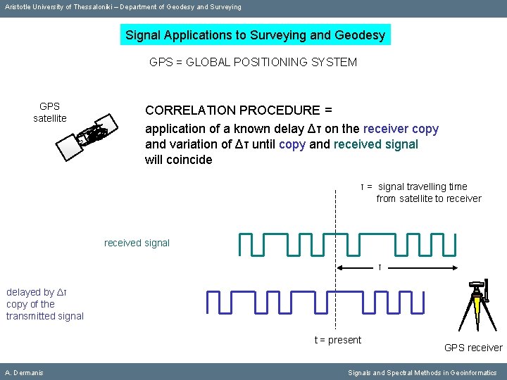
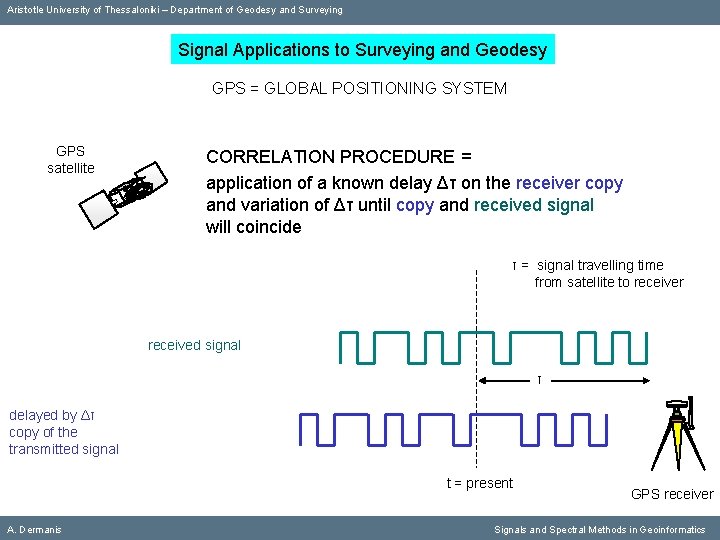
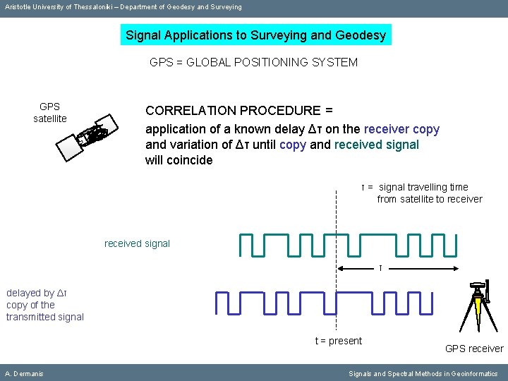
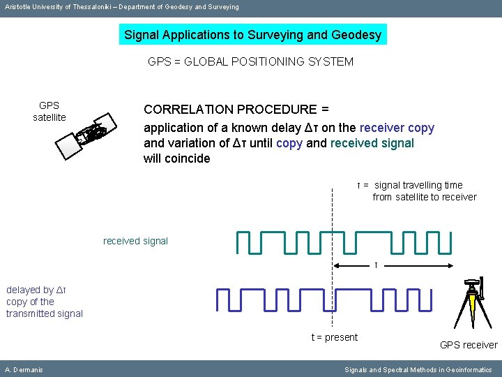
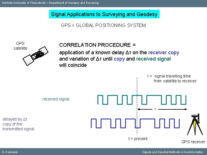
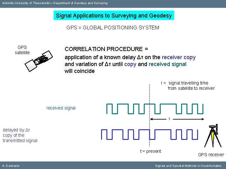
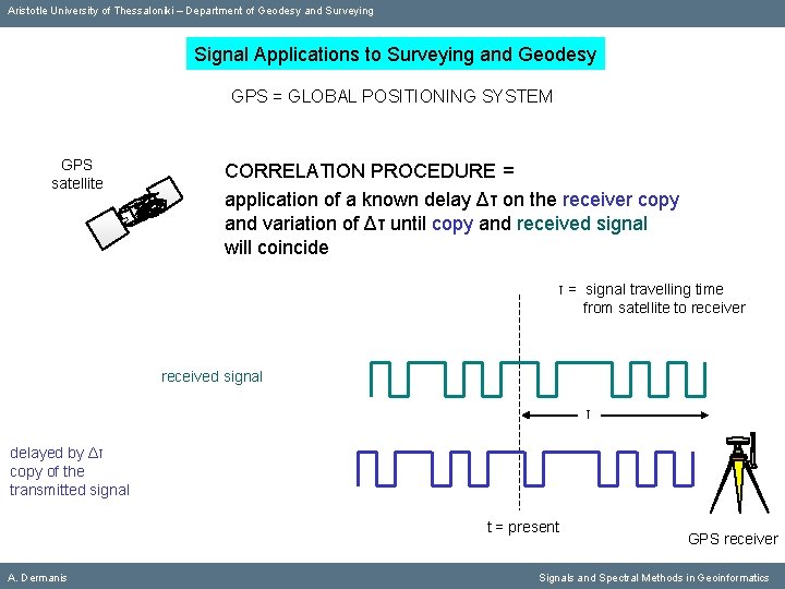
Aristotle University of Thessaloniki – Department of Geodesy and Surveying Signal Applications to Surveying and Geodesy GPS = GLOBAL POSITIONING SYSTEM GPS satellite CORRELATION PROCEDURE = application of a known delay Δτ on the receiver copy and variation of Δτ until copy and received signal will coincide τ = signal travelling time from satellite to receiver received signal τ simultaneous copy of the transmitted signal (produced in receiver) t = present A. Dermanis GPS receiver Signals and Spectral Methods in Geoinformatics
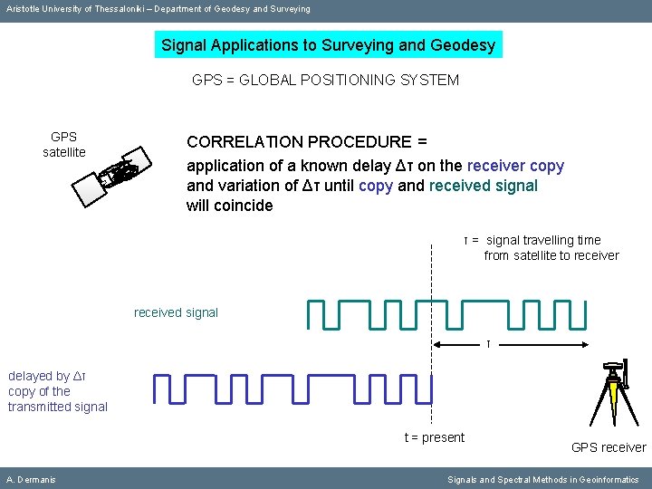
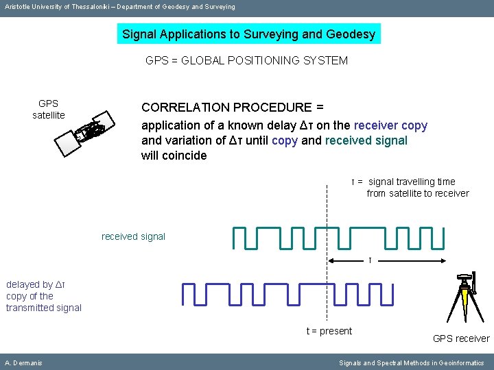
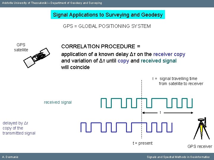
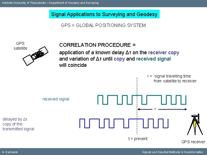
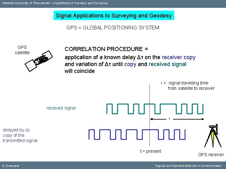
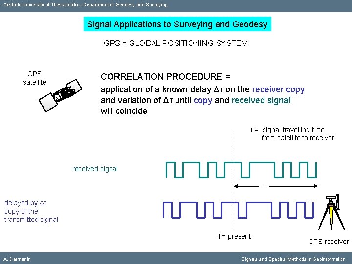
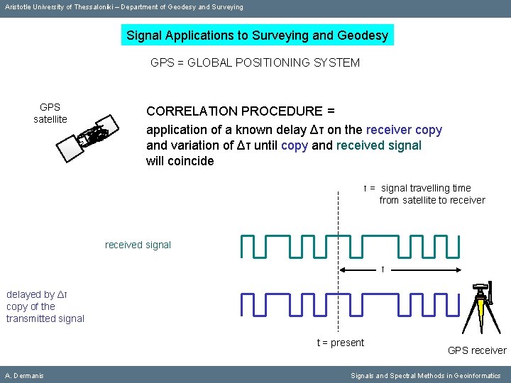
Aristotle University of Thessaloniki – Department of Geodesy and Surveying Signal Applications to Surveying and Geodesy GPS = GLOBAL POSITIONING SYSTEM GPS satellite CORRELATION PROCEDURE = application of a known delay Δτ on the receiver copy and variation of Δτ until copy and received signal will coincide τ = signal travelling time from satellite to receiver received signal τ delayed by Δτ copy of the transmitted signal t = present A. Dermanis GPS receiver Signals and Spectral Methods in Geoinformatics
Aristotle University of Thessaloniki – Department of Geodesy and Surveying Signal Applications to Surveying and Geodesy GPS = GLOBAL POSITIONING SYSTEM GPS satellite CORRELATION PROCEDURE = application of a known delay Δτ on the receiver copy and variation of Δτ until copy and received signal will coincide τ = signal travelling time from satellite to receiver received signal τ delayed by Δτ copy of the transmitted signal t = present A. Dermanis GPS receiver Signals and Spectral Methods in Geoinformatics
Aristotle University of Thessaloniki – Department of Geodesy and Surveying Signal Applications to Surveying and Geodesy GPS = GLOBAL POSITIONING SYSTEM GPS satellite CORRELATION PROCEDURE = application of a known delay Δτ on the receiver copy and variation of Δτ until copy and received signal will coincide τ = signal travelling time from satellite to receiver received signal τ delayed by Δτ copy of the transmitted signal t = present A. Dermanis GPS receiver Signals and Spectral Methods in Geoinformatics
Aristotle University of Thessaloniki – Department of Geodesy and Surveying Signal Applications to Surveying and Geodesy GPS = GLOBAL POSITIONING SYSTEM GPS satellite CORRELATION PROCEDURE = application of a known delay Δτ on the receiver copy and variation of Δτ until copy and received signal will coincide τ = signal travelling time from satellite to receiver received signal τ delayed by Δτ copy of the transmitted signal t = present A. Dermanis GPS receiver Signals and Spectral Methods in Geoinformatics
Aristotle University of Thessaloniki – Department of Geodesy and Surveying Signal Applications to Surveying and Geodesy GPS = GLOBAL POSITIONING SYSTEM GPS satellite CORRELATION PROCEDURE = application of a known delay Δτ on the receiver copy and variation of Δτ until copy and received signal will coincide τ = signal travelling time from satellite to receiver received signal τ delayed by Δτ copy of the transmitted signal t = present A. Dermanis GPS receiver Signals and Spectral Methods in Geoinformatics
Aristotle University of Thessaloniki – Department of Geodesy and Surveying Signal Applications to Surveying and Geodesy GPS = GLOBAL POSITIONING SYSTEM GPS satellite CORRELATION PROCEDURE = application of a known delay Δτ on the receiver copy and variation of Δτ until copy and received signal will coincide τ = signal travelling time from satellite to receiver received signal τ delayed by Δτ copy of the transmitted signal t = present A. Dermanis GPS receiver Signals and Spectral Methods in Geoinformatics
Aristotle University of Thessaloniki – Department of Geodesy and Surveying Signal Applications to Surveying and Geodesy GPS = GLOBAL POSITIONING SYSTEM GPS satellite CORRELATION PROCEDURE = application of a known delay Δτ on the receiver copy and variation of Δτ until copy and received signal will coincide τ = signal travelling time from satellite to receiver received signal τ delayed by Δτ copy of the transmitted signal t = present A. Dermanis GPS receiver Signals and Spectral Methods in Geoinformatics
Aristotle University of Thessaloniki – Department of Geodesy and Surveying Signal Applications to Surveying and Geodesy GPS = GLOBAL POSITIONING SYSTEM GPS satellite CORRELATION PROCEDURE = application of a known delay Δτ on the receiver copy and variation of Δτ until copy and received signal will coincide τ = signal travelling time from satellite to receiver received signal τ delayed by Δτ copy of the transmitted signal t = present A. Dermanis GPS receiver Signals and Spectral Methods in Geoinformatics
Aristotle University of Thessaloniki – Department of Geodesy and Surveying Signal Applications to Surveying and Geodesy GPS = GLOBAL POSITIONING SYSTEM GPS satellite CORRELATION PROCEDURE = application of a known delay Δτ on the receiver copy and variation of Δτ until copy and received signal will coincide τ = signal travelling time from satellite to receiver received signal τ delayed by Δτ copy of the transmitted signal t = present A. Dermanis GPS receiver Signals and Spectral Methods in Geoinformatics
Aristotle University of Thessaloniki – Department of Geodesy and Surveying Signal Applications to Surveying and Geodesy GPS = GLOBAL POSITIONING SYSTEM GPS satellite CORRELATION PROCEDURE = application of a known delay Δτ on the receiver copy and variation of Δτ until copy and received signal will coincide τ = signal travelling time from satellite to receiver received signal τ delayed by Δτ copy of the transmitted signal t = present A. Dermanis GPS receiver Signals and Spectral Methods in Geoinformatics
Aristotle University of Thessaloniki – Department of Geodesy and Surveying Signal Applications to Surveying and Geodesy GPS = GLOBAL POSITIONING SYSTEM GPS satellite CORRELATION PROCEDURE = application of a known delay Δτ on the receiver copy and variation of Δτ until copy and received signal will coincide τ = signal travelling time from satellite to receiver received signal τ delayed by Δτ copy of the transmitted signal t = present A. Dermanis GPS receiver Signals and Spectral Methods in Geoinformatics
Aristotle University of Thessaloniki – Department of Geodesy and Surveying Signal Applications to Surveying and Geodesy GPS = GLOBAL POSITIONING SYSTEM GPS satellite CORRELATION PROCEDURE = application of a known delay Δτ on the receiver copy and variation of Δτ until copy and received signal will coincide τ = signal travelling time from satellite to receiver received signal τ delayed by Δτ copy of the transmitted signal t = present A. Dermanis GPS receiver Signals and Spectral Methods in Geoinformatics
Aristotle University of Thessaloniki – Department of Geodesy and Surveying Signal Applications to Surveying and Geodesy GPS = GLOBAL POSITIONING SYSTEM GPS satellite CORRELATION PROCEDURE = application of a known delay Δτ on the receiver copy and variation of Δτ until copy and received signal will coincide τ = signal travelling time from satellite to receiver received signal τ delayed by Δτ copy of the transmitted signal t = present A. Dermanis GPS receiver Signals and Spectral Methods in Geoinformatics
Aristotle University of Thessaloniki – Department of Geodesy and Surveying Signal Applications to Surveying and Geodesy GPS = GLOBAL POSITIONING SYSTEM GPS satellite CORRELATION PROCEDURE = application of a known delay Δτ on the receiver copy and variation of Δτ until copy and received signal will coincide τ = signal travelling time from satellite to receiver received signal τ delayed by Δτ copy of the transmitted signal t = present A. Dermanis GPS receiver Signals and Spectral Methods in Geoinformatics
Aristotle University of Thessaloniki – Department of Geodesy and Surveying Signal Applications to Surveying and Geodesy GPS = GLOBAL POSITIONING SYSTEM GPS satellite CORRELATION PROCEDURE = application of a known delay Δτ on the receiver copy and variation of Δτ until copy and received signal will coincide τ = signal travelling time from satellite to receiver received signal τ delayed by Δτ copy of the transmitted signal t = present A. Dermanis GPS receiver Signals and Spectral Methods in Geoinformatics
Aristotle University of Thessaloniki – Department of Geodesy and Surveying Signal Applications to Surveying and Geodesy GPS = GLOBAL POSITIONING SYSTEM GPS satellite CORRELATION PROCEDURE = application of a known delay Δτ on the receiver copy and variation of Δτ until copy and received signal will coincide τ = signal travelling time from satellite to receiver received signal τ delayed by Δτ copy of the transmitted signal t = present A. Dermanis GPS receiver Signals and Spectral Methods in Geoinformatics
Aristotle University of Thessaloniki – Department of Geodesy and Surveying Signal Applications to Surveying and Geodesy GPS = GLOBAL POSITIONING SYSTEM GPS satellite CORRELATION PROCEDURE = application of a known delay Δτ on the receiver copy and variation of Δτ until copy and received signal will coincide τ = signal travelling time from satellite to receiver received signal τ delayed by Δτ copy of the transmitted signal t = present A. Dermanis GPS receiver Signals and Spectral Methods in Geoinformatics
Aristotle University of Thessaloniki – Department of Geodesy and Surveying Signal Applications to Surveying and Geodesy GPS = GLOBAL POSITIONING SYSTEM GPS satellite CORRELATION PROCEDURE = application of a known delay Δτ on the receiver copy and variation of Δτ until copy and received signal will coincide τ = signal travelling time from satellite to receiver received signal τ delayed by Δτ copy of the transmitted signal t = present A. Dermanis GPS receiver Signals and Spectral Methods in Geoinformatics
Aristotle University of Thessaloniki – Department of Geodesy and Surveying Signal Applications to Surveying and Geodesy GPS = GLOBAL POSITIONING SYSTEM GPS satellite CORRELATION PROCEDURE = application of a known delay Δτ on the receiver copy and variation of Δτ until copy and received signal will coincide τ = signal travelling time from satellite to receiver received signal τ delayed by Δτ copy of the transmitted signal t = present A. Dermanis GPS receiver Signals and Spectral Methods in Geoinformatics
Aristotle University of Thessaloniki – Department of Geodesy and Surveying Signal Applications to Surveying and Geodesy GPS = GLOBAL POSITIONING SYSTEM GPS satellite CORRELATION PROCEDURE = application of a known delay Δτ on the receiver copy and variation of Δτ until copy and received signal will coincide τ = signal travelling time from satellite to receiver received signal τ delayed by Δτ copy of the transmitted signal t = present A. Dermanis GPS receiver Signals and Spectral Methods in Geoinformatics
Aristotle University of Thessaloniki – Department of Geodesy and Surveying Signal Applications to Surveying and Geodesy GPS = GLOBAL POSITIONING SYSTEM GPS satellite CORRELATION PROCEDURE = application of a known delay Δτ on the receiver copy and variation of Δτ until copy and received signal will coincide τ = signal travelling time from satellite to receiver received signal τ delayed by Δτ copy of the transmitted signal t = present A. Dermanis GPS receiver Signals and Spectral Methods in Geoinformatics
Aristotle University of Thessaloniki – Department of Geodesy and Surveying Signal Applications to Surveying and Geodesy GPS = GLOBAL POSITIONING SYSTEM GPS satellite CORRELATION PROCEDURE = application of a known delay Δτ on the receiver copy and variation of Δτ until copy and received signal will coincide τ = signal travelling time from satellite to receiver received signal τ delayed by Δτ copy of the transmitted signal t = present A. Dermanis GPS receiver Signals and Spectral Methods in Geoinformatics
Aristotle University of Thessaloniki – Department of Geodesy and Surveying Signal Applications to Surveying and Geodesy GPS = GLOBAL POSITIONING SYSTEM GPS satellite CORRELATION PROCEDURE = application of a known delay Δτ on the receiver copy and variation of Δτ until copy and received signal will coincide τ = signal travelling time from satellite to receiver received signal τ delayed by Δτ copy of the transmitted signal t = present A. Dermanis GPS receiver Signals and Spectral Methods in Geoinformatics
Aristotle University of Thessaloniki – Department of Geodesy and Surveying Signal Applications to Surveying and Geodesy GPS = GLOBAL POSITIONING SYSTEM GPS satellite CORRELATION PROCEDURE = application of a known delay Δτ on the receiver copy and variation of Δτ until copy and received signal will coincide τ = signal travelling time from satellite to receiver received signal τ delayed by Δτ copy of the transmitted signal t = present A. Dermanis GPS receiver Signals and Spectral Methods in Geoinformatics
Aristotle University of Thessaloniki – Department of Geodesy and Surveying Signal Applications to Surveying and Geodesy GPS = GLOBAL POSITIONING SYSTEM GPS satellite CORRELATION PROCEDURE = application of a known delay Δτ on the receiver copy and variation of Δτ until copy and received signal will coincide τ = signal travelling time from satellite to receiver received signal τ delayed by Δτ copy of the transmitted signal t = present A. Dermanis GPS receiver Signals and Spectral Methods in Geoinformatics
Aristotle University of Thessaloniki – Department of Geodesy and Surveying Signal Applications to Surveying and Geodesy GPS = GLOBAL POSITIONING SYSTEM GPS satellite CORRELATION PROCEDURE = application of a known delay Δτ on the receiver copy and variation of Δτ until copy and received signal will coincide τ = signal travelling time from satellite to receiver received signal τ delayed by Δτ copy of the transmitted signal t = present A. Dermanis GPS receiver Signals and Spectral Methods in Geoinformatics
Aristotle University of Thessaloniki – Department of Geodesy and Surveying Signal Applications to Surveying and Geodesy GPS = GLOBAL POSITIONING SYSTEM GPS satellite CORRELATION PROCEDURE = application of a known delay Δτ on the receiver copy and variation of Δτ until copy and received signal will coincide τ = signal travelling time from satellite to receiver received signal τ delayed by Δτ copy of the transmitted signal t = present A. Dermanis GPS receiver Signals and Spectral Methods in Geoinformatics
Aristotle University of Thessaloniki – Department of Geodesy and Surveying Signal Applications to Surveying and Geodesy GPS = GLOBAL POSITIONING SYSTEM GPS satellite CORRELATION PROCEDURE = application of a known delay Δτ on the receiver copy and variation of Δτ until copy and received signal will coincide τ = signal travelling time from satellite to receiver received signal τ delayed by Δτ copy of the transmitted signal t = present A. Dermanis GPS receiver Signals and Spectral Methods in Geoinformatics
Aristotle University of Thessaloniki – Department of Geodesy and Surveying Signal Applications to Surveying and Geodesy GPS = GLOBAL POSITIONING SYSTEM GPS satellite CORRELATION PROCEDURE = application of a known delay Δτ on the receiver copy and variation of Δτ until copy and received signal will coincide τ = signal travelling time from satellite to receiver received signal τ delayed by Δτ copy of the transmitted signal t = present A. Dermanis GPS receiver Signals and Spectral Methods in Geoinformatics
Aristotle University of Thessaloniki – Department of Geodesy and Surveying Signal Applications to Surveying and Geodesy GPS = GLOBAL POSITIONING SYSTEM GPS satellite CORRELATION PROCEDURE = application of a known delay Δτ on the receiver copy and variation of Δτ until copy and received signal will coincide τ = signal travelling time from satellite to receiver received signal τ delayed by Δτ copy of the transmitted signal t = present A. Dermanis GPS receiver Signals and Spectral Methods in Geoinformatics
Aristotle University of Thessaloniki – Department of Geodesy and Surveying Signal Applications to Surveying and Geodesy GPS = GLOBAL POSITIONING SYSTEM GPS satellite CORRELATION PROCEDURE = application of a known delay Δτ on the receiver copy and variation of Δτ until copy and received signal will coincide τ = signal travelling time from satellite to receiver received signal τ delayed by Δτ copy of the transmitted signal t = present A. Dermanis GPS receiver Signals and Spectral Methods in Geoinformatics
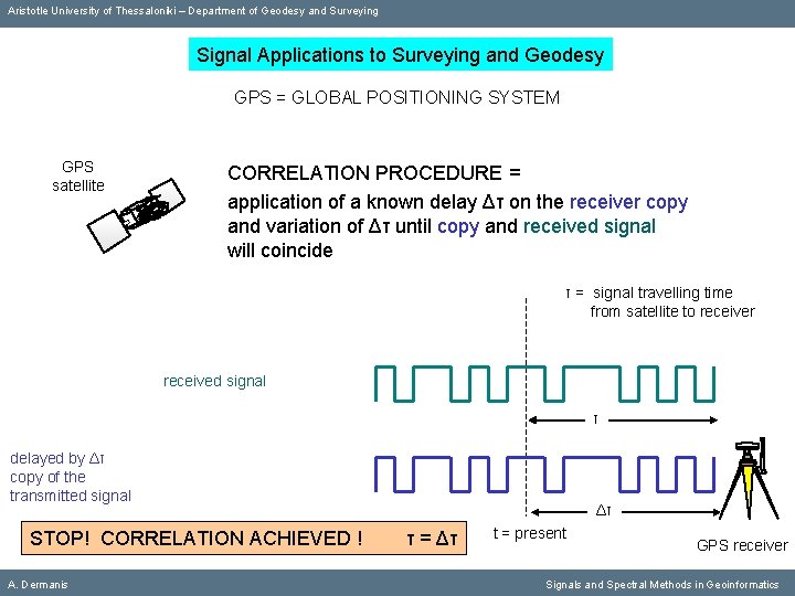
Aristotle University of Thessaloniki – Department of Geodesy and Surveying Signal Applications to Surveying and Geodesy GPS = GLOBAL POSITIONING SYSTEM GPS satellite CORRELATION PROCEDURE = application of a known delay Δτ on the receiver copy and variation of Δτ until copy and received signal will coincide τ = signal travelling time from satellite to receiver received signal τ delayed by Δτ copy of the transmitted signal STOP! CORRELATION ACHIEVED ! A. Dermanis Δτ τ = Δτ t = present GPS receiver Signals and Spectral Methods in Geoinformatics
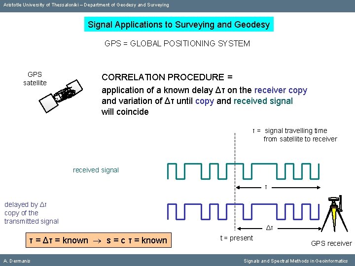
Aristotle University of Thessaloniki – Department of Geodesy and Surveying Signal Applications to Surveying and Geodesy GPS = GLOBAL POSITIONING SYSTEM GPS satellite CORRELATION PROCEDURE = application of a known delay Δτ on the receiver copy and variation of Δτ until copy and received signal will coincide τ = signal travelling time from satellite to receiver received signal τ delayed by Δτ copy of the transmitted signal τ = Δτ = known s = c τ = known A. Dermanis Δτ t = present GPS receiver Signals and Spectral Methods in Geoinformatics
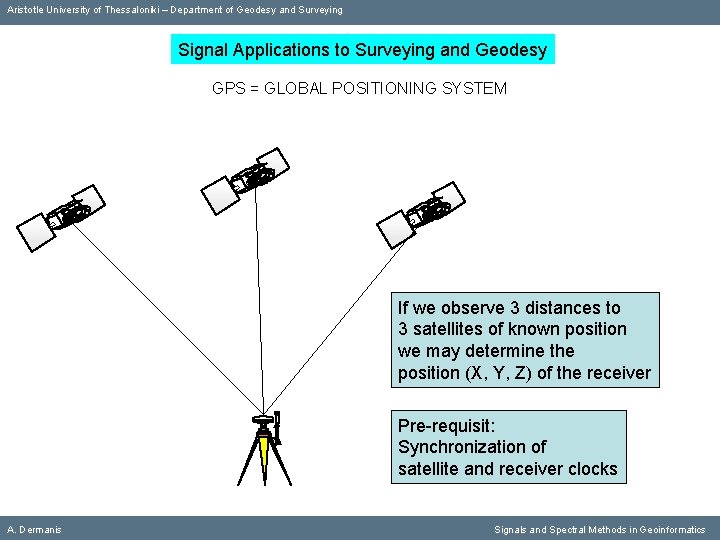
Aristotle University of Thessaloniki – Department of Geodesy and Surveying Signal Applications to Surveying and Geodesy GPS = GLOBAL POSITIONING SYSTEM If we observe 3 distances to 3 satellites of known position we may determine the position (X, Y, Z) of the receiver Pre-requisit: Synchronization of satellite and receiver clocks A. Dermanis Signals and Spectral Methods in Geoinformatics
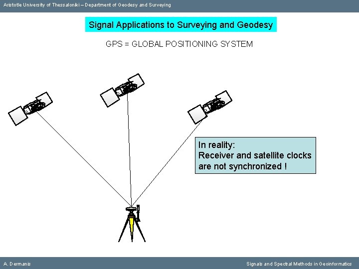
Aristotle University of Thessaloniki – Department of Geodesy and Surveying Signal Applications to Surveying and Geodesy GPS = GLOBAL POSITIONING SYSTEM In reality: Receiver and satellite clocks are not synchronized ! A. Dermanis Signals and Spectral Methods in Geoinformatics
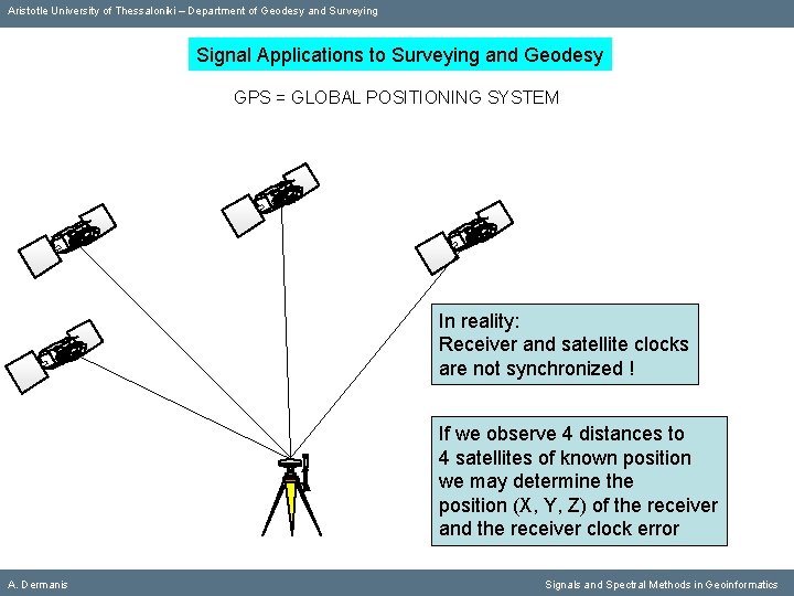
Aristotle University of Thessaloniki – Department of Geodesy and Surveying Signal Applications to Surveying and Geodesy GPS = GLOBAL POSITIONING SYSTEM In reality: Receiver and satellite clocks are not synchronized ! If we observe 4 distances to 4 satellites of known position we may determine the position (X, Y, Z) of the receiver and the receiver clock error A. Dermanis Signals and Spectral Methods in Geoinformatics
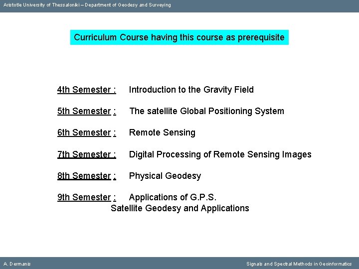
Aristotle University of Thessaloniki – Department of Geodesy and Surveying Curriculum Course having this course as prerequisite 4 th Semester : Introduction to the Gravity Field 5 th Semester : The satellite Global Positioning System 6 th Semester : Remote Sensing 7 th Semester : Digital Processing of Remote Sensing Images 8 th Semester : Physical Geodesy 9 th Semester : Applications of G. P. S. Satellite Geodesy and Applications A. Dermanis Signals and Spectral Methods in Geoinformatics
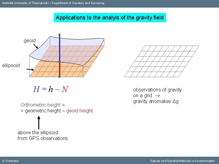
Aristotle University of Thessaloniki – Department of Geodesy and Surveying Applications to the analyis of the gravity field geoid ellipsoid Η=h N Orthometric height = = geometric height – geoid height observations of gravity on a grid gravity anomalies Δg above the ellipsoid from GPS observations A. Dermanis Signals and Spectral Methods in Geoinformatics
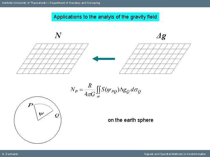
Aristotle University of Thessaloniki – Department of Geodesy and Surveying Applications to the analyis of the gravity field N Δg on the earth sphere A. Dermanis Signals and Spectral Methods in Geoinformatics
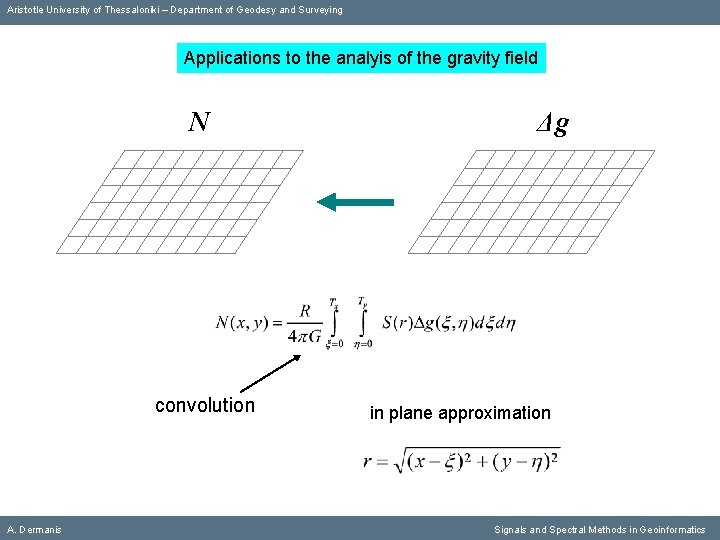
Aristotle University of Thessaloniki – Department of Geodesy and Surveying Applications to the analyis of the gravity field N convolution A. Dermanis Δg in plane approximation Signals and Spectral Methods in Geoinformatics
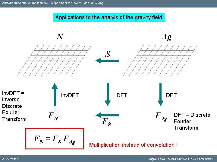
Aristotle University of Thessaloniki – Department of Geodesy and Surveying Applications to the analyis of the gravity field N Δg S inv. DFT = inverse Discrete Fourier Transform inv. DFT FN FN = FS FΔg A. Dermanis DFT FS DFT FΔg DFT = Discrete Fourier Transform Multiplication instead of convolution ! Signals and Spectral Methods in Geoinformatics
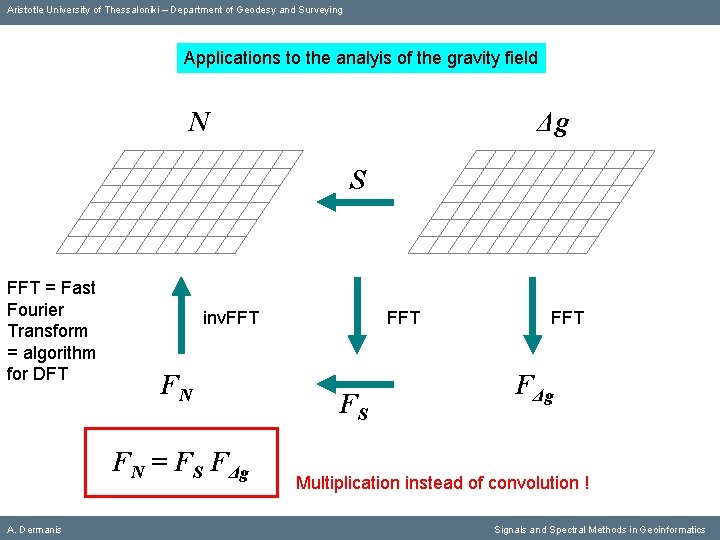
Aristotle University of Thessaloniki – Department of Geodesy and Surveying Applications to the analyis of the gravity field N Δg S FFT = Fast Fourier Transform = algorithm for DFT inv. FFT FN FN = FS FΔg A. Dermanis FFT FS FFT FΔg Multiplication instead of convolution ! Signals and Spectral Methods in Geoinformatics
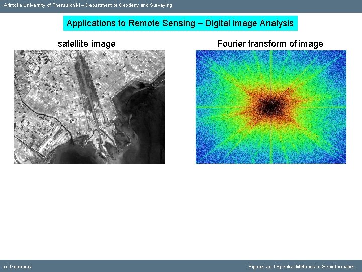
Aristotle University of Thessaloniki – Department of Geodesy and Surveying Applications to Remote Sensing – Digital image Analysis satellite image A. Dermanis Fourier transform of image Signals and Spectral Methods in Geoinformatics
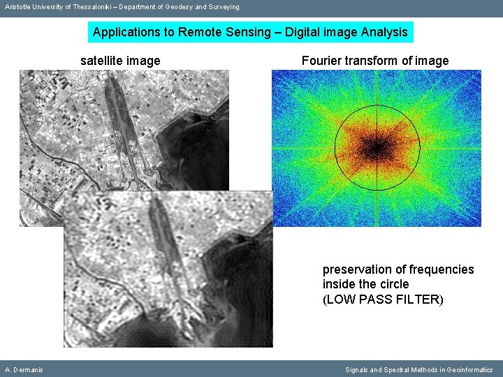
Aristotle University of Thessaloniki – Department of Geodesy and Surveying Applications to Remote Sensing – Digital image Analysis satellite image Fourier transform of image preservation of frequencies inside the circle (LOW PASS FILTER) A. Dermanis Signals and Spectral Methods in Geoinformatics
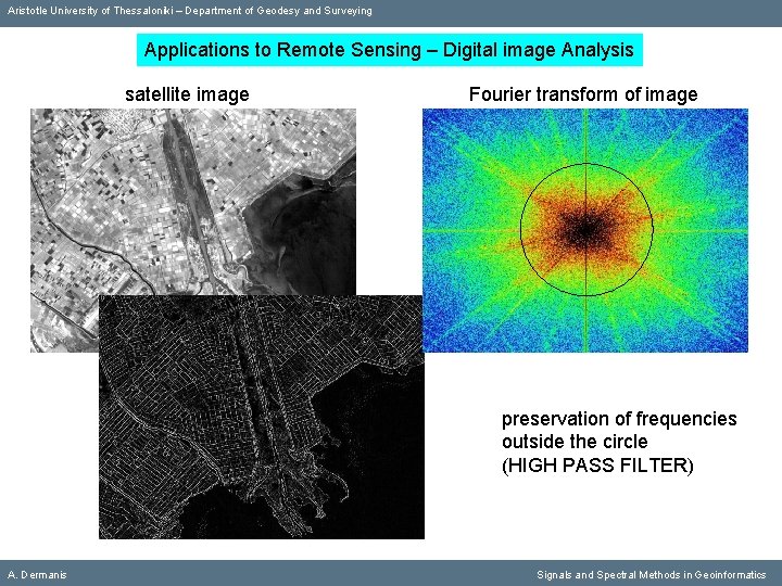
Aristotle University of Thessaloniki – Department of Geodesy and Surveying Applications to Remote Sensing – Digital image Analysis satellite image Fourier transform of image preservation of frequencies outside the circle (HIGH PASS FILTER) A. Dermanis Signals and Spectral Methods in Geoinformatics
Aristotle University of Thessaloniki – Department of Geodesy and Surveying END A. Dermanis Signals and Spectral Methods in Geoinformatics