Arctic and Alpine tundra environments Physical processes and


 form where the drainage of a lake")


 is sand which was originally deposited on outwash")


- Slides: 23
Arctic and Alpine tundra environments Physical processes and landforms
Periglacial landforms and processes Arctic tundra LANDFORMS PROCESSES Patterned ground Stone stripes Ice wedges Pingos Palsas Alases Thaw lakes Loess (limon) Gelifluction lobes Cryoturbation (frost heave) Needle ice Ground contraction Frost weathering (frost shattering) Gelifluction (frost creep) Nivation Meltwater Aeolian action Thermokarst
Processes of frost heaving and ground contraction produce patterned ground. Patterned ground
Frost heave results in the formation of ice crystals and lenses in the soil. These preferentially form under stones as their thermal conductivity is greater than soil. Stones are forced upwards to the surface where they can roll downslope. During times of thaw fine material is left by meltwater under the stones so they cannot fall back to the original position. With phases of repeated freezing and thawing material is sorted to leave patterned ground, dome shaped polygons with larger stones on the outside. (above) On slopes polygons become stripes. Ground contraction during freezing and thawing episodes creates cracks similar to mudcracks on a dried up lake bed. Polygons produced this way are larger with the centre being lower containing the biggest stones. (left)
Ice wedges may be between 10 mm and 3 m wide and penetrate up to 10 m into the frozen ground. Severe winter cooling causes the contraction of near-surface permafrost. The stresses so produced within the soil are relieved by cracking. A polygonal network of vertical cracks develop. These are accentuated over time as snow and meltwater enter the cracks and refreeze time after time. The snow and water also prevent the cracks from closing up.
Cryoturbation Freezing and thawing in soils helps to churn up the soil. This process, cryoturbation, is especially active in the active layer above permafrost. Soil layers can become inverted (involutions).
Pingos are dome-shaped, isolated hills found on flat tundra plains. They are up to 500 m across and 50 m in height. An ice core may often be exposed as in the example below. They mainly occur in sand, especially in river deltas.
Closed system pingos (or Mackenzie type pingos) form where the drainage of a lake leads to the refreezing of the talik underneath as the insulating effect of the water is lost. The advance of the permafrost from both sides and underneath leads to the uplifting of the surface as the ice takes up more space than the unfrozen talik. . Pingos are very common in the delta of the Mackenzie River. At least 1380 have been counted here, most near to lake basins. Open system pingos (or east Greenland type) develop where water flows downhill underneath a frozen layer. The artesian pressure of the water forces more water into the gap which then freezes and forms the dome.
Palsas are similar in shape to pingos but are smaller and their core is composed of peat and other soil material. They are generally a few metres high and are common in bogs in the discontinuous permafrost zone. When the ice melts and the palsas decay a shallow hole is left which can fill with a small shallow pond.
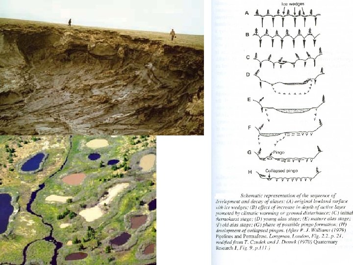
Alases and thaw lakes When permafrost degradation occurs because of climatic change subsidence will happen as the ground ice melts. The depth of subsidence depends on the depth of thaw and on the ice content of the upper layers of permafrost. The small ponds that result further enhance permafrost degradation as latent heat is released during the freezing of pond waters increasing the depth of the pond. They gradually grow into shallow thaw lakes, common in Alaska and Canada. In Siberia the permafrost tends to be deeper and alases tend to form. These are wider deeper depressions, often without a lake.
Loess (sometimes referred to as limon) is sand which was originally deposited on outwash plains where streams flow away from glaciers. Wind blows the sand to other areas and can deposit it in thick layers. The above map shows areas of loess deposition in the USA. Loess also occurs in Northern Europe, but the most famous area is Northern China (left), where the yellow loess deposits are eroded by the Hwang He River (the Yellow River, which leads to the Yellow Sea).
Gelifluction is the periglacial equivalent of solifluction. Summer thaw produces a saturated active layer which then flows over the frozen permafrost. Gelifluction also produces lobes of material, tongue like shapes up to 50 m across and 1 m high.
Nivation hollows Nivation or snowpatch erosion is not one geomorphological process but a collective term for the processes of weathering and transport which are accelerated by late-lying snow. These include freeze-thaw activity, slopewash, snowcreep and solifluction. They are held to be the starting block for the formation of corries or cirques.
Frost weathering This is the most widespread form of physical weathering occurring in rocks which contain crevices and joints and where the temperature oscillates around 0°C. During the daytime water enters the joints and freezes as the temperature drops at night. Ice occupies 9% more volume than water so pressure is placed upon the rock which splits and breaks away. The broken material collects as a scree or talus slope beneath the cliff.
Periglacial landforms and processes Alpine tundra LANDFORMS PROCESSES Corries / cirques Hanging valleys Alps Felsenmeer / blockfields Rock glaciers Solifluction lobes Altiplanation terraces Cryoturbation (frost heave) Frost weathering (frost shattering) Nivation Meltwater Soil creep Solifluction
Corries /cirques One of the major features of glaciated areas is the armchair shaped valleys eroded by the processes of abrasion and plucking underneath a glacier. Corrie or cirque glaciers combine to create deeper valleys called troughs or U-shaped valleys.
Hanging valleys When glaciers join together the joint weight and erosive effect enables the glacier to erode deeper. The previous valleys are left high above the floor of the new valley or trough. These smaller valleys are called hanging valleys.
Felsenmeer / blockfields Relatively flat areas where rock is at the surface may undergo intense physical weathering. Frost action may split the rocks up into a jumble of large angular boulders. These are known as blockfields, or felsenmeer (boulder seas in German). Felsenmeer are common in Snowdonia where they are known as cludeiriau in Welsh hence the name for the high mountains in Snowdonia Glyder Fawr and Glyder Fach (above).
Rock glaciers A feature in a mountain area which looks like a glacier but which is composed of rock debris. Two theories account for their shape. Some researchers believe that ice exists within pore spaces between the rocks, others that the rock is a thick covering on a thin true glacier. They usually move very slowly (less than a metre per year)
This process of mass movement meaning soil flow averages between 5 and 20 cm per year. Saturated soil flows gradually downslope. This can occur on slopes as gentle as 1° but is particularly active in periglacial environments where the combination of ice in the soil and the freezing and thawing cycle make for an accelerated process. A lobe (tongue shaped feature) is produced up to 50 m across and 1 m high. Where found in Britain at the foot of valleys and sea cliffs it is called head. If the head is derived from weathered chalk rock the term coombe rock is preferred. Solifluction lobes
A sequence of deposits including soliflucted head at Morannedd, Criccieth, Gwynedd.
Altiplanation terraces, also called cryoplanation terraces, are level or gently sloping surfaces found in the periglacial zone cut into bedrock on hill summits or upper hillslopes. Rock type and structural factors such as faults may be important in determining their formation. Once again several factors working in conjunction are thought to be responsible for their formation.