African Civilizations African Geography Africa is the worlds


- Slides: 48
African Civilizations
African Geography • Africa is the world’s second largest continent by total area. • Africa is the world’s second largest continent by population. • Africa’s history and cultures usually gets divided into two parts: • Saharan Africa • Sub-Saharan Africa
A Satellite View
Africa’s Size 4600 MILES 5 0 0 0 M I L E S # Second largest continent 11, 700, 000 sq. mi. # 10% of the world’s population. # 2 ½ times the size of the U. S.
The Sahara • Size • Represents, by total area, the largest desert in the world. • As large as the contiguous United States • Climate • Extremely Hot • Highest recorded temperature - 137˚F (Libya) • Extremely Cold • Overnight lows in the 40’s. • Precipitation is minimal, averaging less than 10 inches per year. • However, this process began only a few thousand years ago. • Other conditions include intense sunlight and sandstorms.
Geographic Terms/Locations Water: Mediterranean Sea, Red Sea, Gulf of Aden, Indian Ocean, Atlantic Ocean, Lake Chad, Lake Albert, Lake Victoria, Lake Tanganyika, Lake Malawi/Nyasa, Nile River, Niger River, Congo River, Limpopo River, Orange River, Zambezi River Land: Atlas Mountains, Great Rift Valley, Mount Kilimanjaro, Libyan Desert, Sahara Desert, Sahel, Namib Desert, Kalahari Desert, Madagascar, Horn of Africa, Cape of Good Hope, Projection Data: Tropic of Cancer, Tropic of Capricorn, Equator, Prime Meridian, legend, compass rose, title
Libyan Deserts Sahara Desert Sahel ib D Nam rt ese hari Kala rt e Des
Mediterranean Sea Re a Nig er Nile River Riv e r L. Chad--> <--G o ulf Volta River f. A r. L. Albert--> ve ng i o. R Co den Water Se Of d Bodies L. Victoria L. Tanganyika-> Indian Ocean Atlantic Ocean Zambezi River Lake Malawi. Limpopo River Orange River
People • Desert populations, from the beginning up to today, live near reliable water sources including underground springs and oases • Mostly mildly nomadic, limited agriculture due to scarcity of water.
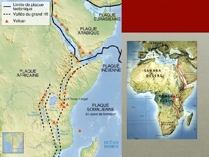
Sub-Saharan Africa Features • An enormous plateau surrounded by a narrow coastal plain characterizes Sub-Saharan Africa. • The Great Rift Valley dominates the landscape of Eastern Africa. • It cuts through the continent from the Gulf of Suez in the north to Mozambique in the south. • In some places, the walls of the valley are one mile high. • Because of its elevation, parts of East Africa are cool even though they lie along the equator. • Nairobi in the summer remains cooler than Atlanta.
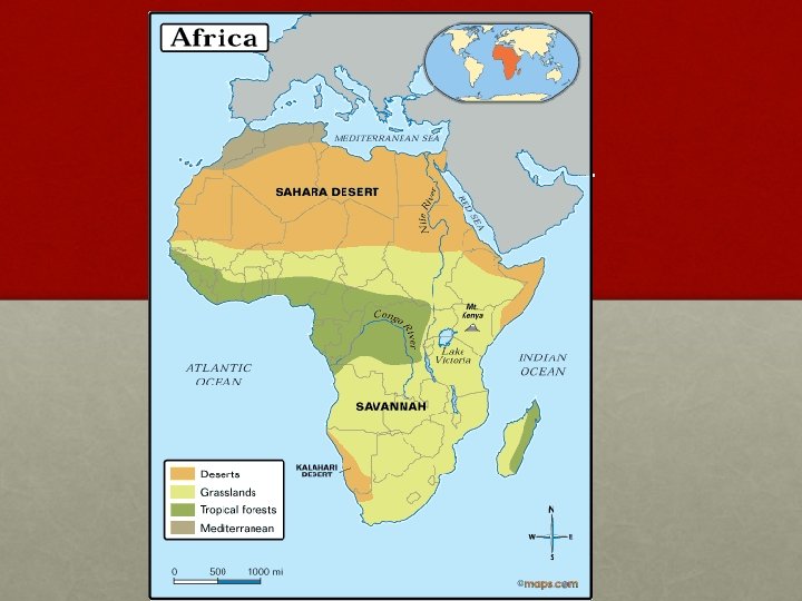
Geographic Zones • Sub-Saharan Africa can be broken into distinct climate zones, beginning with the equator and then progressing out. • Rainforest • Most of equatorial Africa is tropical rain forest. • Average rain fall- 100 inches per year. • Vegetation – rich and diversified.
Geographic Zones • Terms • Deserts, Grasslands, Tropical Forests, Mediterranean, Savannah, Sahara • Tropic of Cancer, Tropic of Capricorn, Equator, Prime Meridian
Grasslands • North and South of the rainforests are “Savannahs” • Regions marked by distinct hot/dry & cool/wet seasons. • Home to most of the wildlife associated with Africa’s plains
Arid Regions • North of the “northern grasslands” lies the semi-arid region known as the Sahel, Arabic for “border”. • Facing “extinction” due to desertification. • Southwest of the southern grasslands lie two more famous African deserts – the Kalahari and the Namib.
Southern Africa • The region enjoys a much milder and consistent climate. • Contains the continent’s most productive farmland.
as Atl a Sahel Nig er Riv L. Chad--> er o ulf Rift V <--G alley Nile River Equator 0° Co L. Tanganyika-> ib D Nam Atlantic Ocean Zambezi River ese Lake Malawi. rt hari Kala rt e. Limpopo River Des Orange River Mts. rg bu s n aje Dr Indian Ocean Tropic of Capricorn 20° S Cape of Good Hope Madagascar den Great f. A Horn of Africa L. Albert--> r Δ Mt. Kenya ve i R o ng L. Victoria Δ Mt. Kilimanjaro Of AFRICA Se Sahara Desert Complete Topography Libyan Desert d Tropic of Cancer 20° N Mediterranean Sea Re The M ts.
Ancient Africa
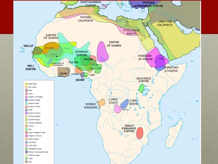
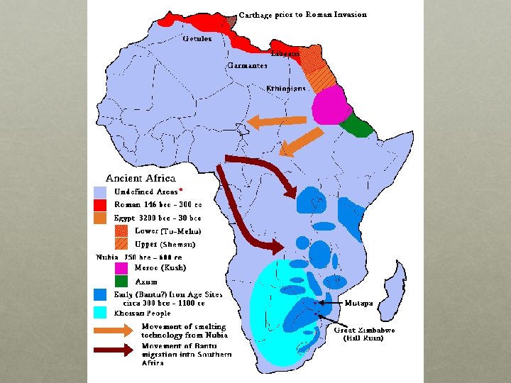
Nubia & Kush • The Nubians established a society along the southern part of the Nile River by 3, 000 B. C. • It prospered as a military society that conquered neighboring peoples to the south and east. • Inhabitants traded with and tried to exert pressure on Egypt. • By 2, 000 B. C. , the civilization evolved into a kingdom known as Kush. • • • Defeated and conquered by Egypt around 1, 500 B. C. Ruled over by Egypt for more than 500 years. Developed into a mercantile nation at this point. • Napata and Meroë – two most important trade centers.
Nubia & Kush continued • Around 1, 000 B. C. the Kushites broke free from Egyptian control as Egypt’s “New Kingdom” began its decline. • In 724 B. C. , King Piankhi succeeded in conquering Egypt. • The Kushites ruled over Egypt until the Assyrian invasion in 671 BC • The Kushites concentrated around Meroë, which again became an important trade hub, with the region gaining power as an important production center for iron.
Axum • …or Aksum • Located along the Red Sea in modern-day Ethiopia, Axum was an important trade center, controlling shipping along the Red Sea & Eastern Indian Ocean. • Its contact with Egypt, Arabia, India, and Persia brought an influx of ideas, cultures, and technologies.
Religious Influx • Christianity entered Eastern Africa in the 4 th century A. D. • Two shipwrecked Syrians, according to legend, converted King Ezana. • In 330 A. D. , Ezana made Christianity the official state religion. • Axumite, later Ethiopian, Christians claim the biblical “Queen of Sheba” as a ancestor, as well as several churches still claiming to be the home of the Ark of the Covenant. • Islam reached Askum in the later part of the 600’s A. D. • While a percentage of the population remained Christian, the majority converted to Islam, laying the foundations for modern-day Ethiopia.
Bantu Migrations • The word “Bantu” refers to a group of people that share a common language ancestor – the Bantu family. • The original culture group originated in Western Africa, perhaps around modern day Cameroon. • Although much studied, historians cannot accurately date the beginnings of the Bantu migration. • Some evidence suggest as early as 1, 000 B. C. while other evidence points to a much later date around 500 A. D. , or at leas several distinct waves of migration, like the Indo-Europeans and the Asiatic nomads.
Preparation • The initial success of the Bantu came from their ability to farm. • As techniques improved and populations increased, the Bantu would have had to displace the hunter-gatherers that originally inhabited sub-Saharan Africa. • Eventually, overpopulation probably triggered the massed migration of Bantu Speakers from their West African homeland. • Too many difficult geographic barriers, the Sahel and Tropical rainforests, to convert to farmland cost-effectively. • The Bantu also learned how to forge iron. • Its origins and development amongst the Bantu, however, remains the biggest battle between anthropologists/archaeologists who study the Bantu. • (Obviously, the important matter remains that they did develop the technology. )
Migration • As they moved, the Bantu would slowly mix with the original inhabitants of a particular region. • Led to cultural diffusion but also produced distinct difference in cultural features, such as religious beliefs & rituals, language characteristics. • As one would suspect, the geography & climate of a particular area heavily impacted each group’s development. • In many ways, the Bantu migration mirrors that of the Indo-Europeans, who left their ancestral home around the Black Sea and forever changed Eurasian history.
Desertification and Migration packet • This may not apply to your class, so make sure you talk with Mr. Camillo to find out! • Chapter 8 Section 3 (pg 203) – Start to work on your homework in partners or groups of three to read the section and complete the worksheets. • The entire packet will be checked on the HW Check
Sub-Saharan Africa: - Hunter Gatherers - Cultural Traits
• The hunter-gatherer societies of sub-Saharan Africa, regardless of location, share many of the same cultural traits. • Due, in part, to their contact with & intermingling with the Bantu. • The term “hunter-gatherer” doesn’t rule out lightscale, often seasonal farming practices
Village Government • Small tight-knit communities with clearly defined tribal/family lineages • Work often assigned by age sets, divided in some cases by gender. • Authority often lay in the hands of a single leader. • In some instances, leaders advised by peer groups. • Additionally, many particular issues amongst various groups settled only through the reaching of a consensus amongst the elders.
Family Patterns • The nuclear family acts as the basic organizational unit for these tribes. • Most societies were patrilineal, meaning power and ancestry rested with the father’s family. • Some societies, however, were organized matrilineally. • Great respect, if not too much credence at times, given to one’s lineage. • Common ancestors defined a community’s identity. • “Communing” with ancestors a defining characteristic of these peoples’ religious beliefs. • Beliefs were polytheistic and based on the workings of nature. • Village elders served as religious leaders. • Very often, widowed or unmarried men & women, became the voices of the religion, acting as prophets & soothsayers.
Kingdoms of West Africa
Ghana • A trading empire that existed in W. Africa between 300 & 1200 A. D. • Extended over a territory of more than 100, 000 square miles. • The nation prospered from taxes collected on the commodities that moved throughout its territory. • Traded its agricultural products with North Africa. • Oversaw the highly lucrative gold/salt trade. • Gold originated from the southern parts of West Africa. • Salt originating from the Sahel & southern Sahara regions. • Later in its history, the kingdom became heavily influence by Islam. • The Almoravids, a group of North Africa Muslims, attacked at the end of the 11 th century, converting much of the population. • Eventually, religious and economic issues split the region into many smaller nations.
Mali • Origins • One the small nations that used to make up Ghana. • Its prosperity came from its agricultural production. • It used to be Ghana’s “breadbasket”. • Expansion • By the late 1200’s, Mali controlled the former territory of Ghana. • Restored and prospered from controlling the traditional trade routes. • Mansa Musa – r. 1312 -1332 A. D. • Improved trade and introduced Islam, peacefully, to Mali. • Made a famous pilgrimage to Mecca around the year 1324. • Returned with architects to build mosques and a palace in the capital of Timbuktu. • Decline • After Musa’s death, Mali came under attack from several nations. • It “limped” on until fracturing into smaller nations in the 1500’s.
Mali
Songhai • In the late 1400’s, a ruler name Sunni Ali forged the Songhai Empire out of several smaller states. • After his death, Ali’s son inherited the throne. • However, Ali’s son was not Muslim and the people eventually rebelled. • Zenith • Songhai reached its height under a ruler named Askia Muhammad. • Ruled from 1493 to 1528. • Divided Songhai into five provinces, enabling a more efficient government. • Based the kingdom’s laws on strict adherence to the Koran. • Despite power, his own son eventually overthrew Askia. • Collapse • Askia’s downfall led to a series of civil wars. • Weakened, Songhai came under attack from the powerful state of Morocco. • Songhai, which fell by 1600, represents the last of the great sub-Saharan civilizations of West Africa.
Trade Handout • Answers are on the next slide – don’t look!
Trade Routes handouts • Part A • Ghana • Senegal, Gambia, Niger Rivers • Seven • Five • Segu, Jenne, Timbuktu • Part B • • • Walata Jenne Fish, Tusks, Leopard Skins, Tortoise Shell • Camels through the Sahara, Donkey, Head Porterage etc • Important to its survival, longdistance connections, Various styles of transportation
Great Zimbabwe • Zimbabwe, an inland kingdom, arose in southern Africa. • People were descendants of a Bantu group that moved from East Africa, perhaps at the turn of the Common Era. • Explains why many of its cultural traits seem to possess strong connections to other East Africa groups. • Contact with other civilizations before moving away from East Africa might have brought exposure to new technology. • Zimbabwe’s wealth and power, like the East African kingdoms, came from trade. • The region included large deposits of gold and copper. • Reached its height around 1300 A. D.
Architecture • The people of Zimbabwe built massive stone structures, many of which bear similarity in design to the structures of Axum. • The capital city itself represented the southern-most town defended by walls in the Eastern Hemisphere.
Great Zimbabwe
Great Zimbabwe 2
Decline • For reasons yet unknown, the kingdom underwent a steep decline beginning around 1500 A. D. • Evidence suggests a series of crippling and unresolved civil wars. • Any potential “rebirth” came to an end as Europeans began to colonize the coastal areas on both sides of the kingdom. • This allowed them to take control of trade, taking away the heart of the old empire’s wealth and power – economic prosperity.
Quiz • Some multiple choice and matching • Short answer • Map
as Atl a Sahel Nig er Riv L. Chad--> er o ulf Rift V <--G alley Nile River Equator 0° Co L. Tanganyika-> ib D Nam Atlantic Ocean Zambezi River ese Lake Malawi. rt hari Kala rt e. Limpopo River Des Orange River Mts. rg bu s n aje Dr Indian Ocean Tropic of Capricorn 20° S Cape of Good Hope Madagascar den Great f. A Horn of Africa L. Albert--> r Δ Mt. Kenya ve i R o ng L. Victoria Δ Mt. Kilimanjaro Of AFRICA Se Sahara Desert Complete Topography Libyan Desert d Tropic of Cancer 20° N Mediterranean Sea Re The M ts.