AAPG SALT LAKE CITY 2003 PETROLEUM POTENTIAL OF


 WALU – 1")
 ELGAL – 1 AMOCO 1, 280 ELGAL – 2")


 Lithology: Dark grey")


 evidently revolves around the proven Oligocene")


 Depositional")


- Slides: 47
AAPG SALT LAKE CITY 2003 PETROLEUM POTENTIAL OF KENYA By Albert Maende EXPLORATION & PRODUCTION MANAGER, NATIONAL OIL CORPORATION OF KENYA
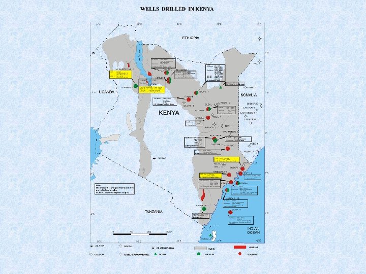
EXPLORATION HISTORY PREVIOUS DRILLING v Petroleum Exploration in Kenya begun in the 1950’s with the first well being drilled in 1960. v Between 1960 and 1981, 15 wells were drilled. v 4 of these wells were in Anza Basin while the remaining 11 were in Lamu. v None-penetrated what the Operators could consider as commercial deposits of petroleum. v Two of these wells tested gas at 3. 1 mcf/d and 12. 7 mcf/d respectively. v However, all the 14 wells were plugged and abandoned. v Between 1981 and 1993, 15 wells were drilled in Kenya.
v 2 of these wells were offshore Lamu basin, one onshore Lamu , 10 were in Anza while 2 were drilled in the Tertiary Rift. v 9 of these wells encountered oil and gas shows. v. One well tested gas, one recovered a trace of paraffinic oil while from another, 2 litres of oil were recovered. v. These exploration phases that begun in 1985 and led to the drilling of 12 wells, ended in 1993 when licenses for all the blocks were relinquished.
Lamu Basin Study v The National Oil Corporation of Kenya in 1991 initiated an in-house study of the Lamu basin, which was completed in 1995. v This study integrated for the first time all the well logs, seismic, gravity, aeromagnetic, geological and geochemical data of the basin into a single basin synthesis entitled ‘The Hydrocarbon Potential of the Lamu Basin’.
Tertiary Rift Study v Other than the Lamu basin study, the Tertiary Rift has also been synthesized into a basin study package. This was accomplished in a year 2000 to 2001 program.
ANZA BASIN STUDY v In a similar vein to previous Lamu and Tertiary Rift Basin by Basin Studies, NOCK is currently carrying out the Anza Basin Study. v Anza Basin covers an area of 94, 220 sq Km. v 11 exploratory wells have been drilled in this Basin. v A total of 14, 362 Km seismic lines, 64, 061 Km aeromagnetic data and 15, 891 Km of gravity data have been acquired during previous petroleum exploration work in this Basin.
SUMMARY OF WELLS DRILLED IN KENYA WELL OPERATOR TOTAL DEPTH (M) WALU – 1 BP/SHELL 1, 768 PANDANGUA – 1 BP/SHELL 1, 982 MERI – 1 BP/SHELL 1, 941 MARARANI – 1 BP/SHELL 1, 991 RIA KALUI MEHTA & CO. 1, 537 WALU – 2 BP/SHELL 3, 729 DODORI BP/SHELL 4, 311 WAL MERER BP/SHELL 3, 794 GARISSA BP/SHELL 1, 240 PATE BP/SHELL 4, 188 KIPINI BP/SHELL 3, 663 TEXAS PACIFIC 3, 092 ANZA CHEVRON 3, 662 BAHATI CHEVRON 3, 420 SIMBA (Offshore) TOTAL 3, 604 MARIDADI 1 – B (offshore) CITIES 4, 196 KOFIA (offshore) UNION 3, 658 PETRO-CANADA 3, 863 HAGARSO KENCAN – 1
WELL OPERATOR TOTAL DEPTH (M) ELGAL – 1 AMOCO 1, 280 ELGAL – 2 AMOCO 1, 908 NDOVU – 1 TOTAL 4, 269 SIRIUS – 1 AMOCO 2, 638 BELLATRIX – 1 AMOCO 3, 479 DUMA – 1 TOTAL 3, 337 HOTHORI – 1 AMOCO 4, 394 CHALBI – 3 AMOCO 3, 643 ENDELA – 1 WALTER 2, 780 KAISUT – 1 TOTAL 1, 450 LOPEROT – 1 SHELL 2, 950 ELIYE-SPRINGS – 1 SHELL 2, 964
CURRENT ACTIVITIES EXPLORATION OF BLOCKS L 5, L 7, L 10 AND L 11 BY DANA PETROLEUM TOGETHER WITH GLOBAL PETROLEUM v Dana Petroleum of the U. K. together with Global Petroleum of Australia jointly hold Exploration Licences for 4 Blocks offshore Lamu Basin. v 3 of these Blocks were leased in 2000 while the 4 th one was leased in 2001. v During the first two years that Dana who are the operator and Global, have held these Blocks, they have compiled and interpreted previously acquired geological and geochemical data in there Leased area and subsequently interpreted data from over 4, 500 seismic lines previously shot in these 4 Blocks.
v As a result of these interpretation, they have mapped 4 main plays offshore Lamu Basin. v During this year, Dana will acquire a minimum of new 2000 Km Seismic data in all the four Blocks that they have leased. v These data will be integrated with the over 4, 500 Km Seismic data that they have already sythesized for purposes of locating drillable Petroleum Prospects. v It is anticipated that Dana will drill their first well in 2004.
EXPLORATION OF BLOCKS L 6, L 8 AND L 9 BY AFREX LTD TOGETHER WITH PANCONTINENTAL OIL & GAS nl v Afrex together with Pan. Continental Oil & Gas of Australia jointly hold Exploration licences for 3 Blocks offshore Lamu Basin. v They acquired these licences in August 2002. v During the first two years that these licences are in force the two Companies will focus on compilation and interpretation of available Petroleum Exploration data in their Blocks. v Subsequently, in 2005, at the latest, Afrex and Pan. Continental are expected to acquire a minimum of 900 Km of new Seismic data in their three Blocks and drill a well to test their mapped Petroleum Prospects.
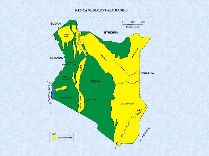
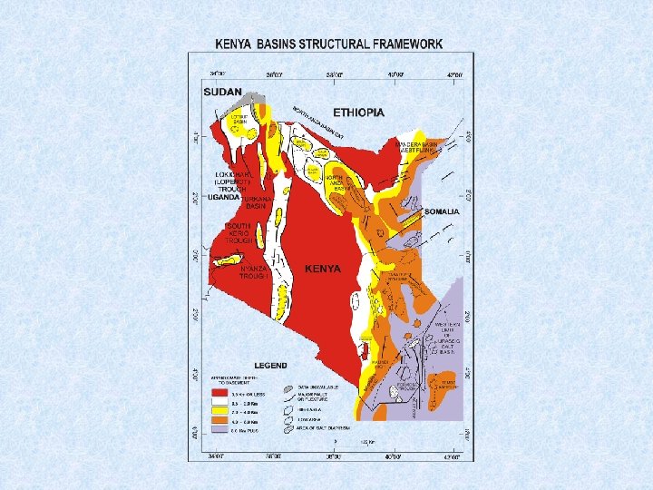
GEOLOGY AND HYDROCARBON POTENTIAL 1. Hydrocarbon Potential of Kenya’s Sedimentary Basins v Kenya’s Petroleum potential is best depicted by the four large sized sedimentary basins that straddle the Country. v These are Lamu, Mandera, Anza and Tertiary Rift basins. v The structural framework map of Kenya shows the basins bounds as well as the various thicknesses of sediments in the four basins.
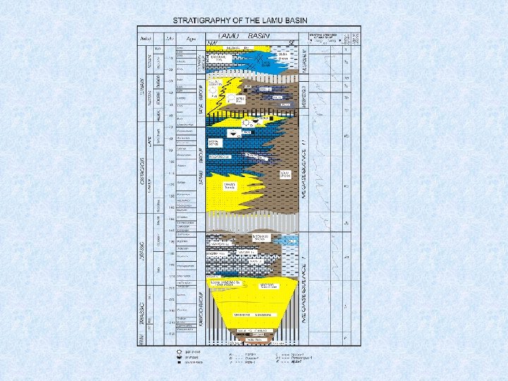
1. 1. Lamu basin v From the South East corner of the Country stepping out of the Indian Ocean is our most ancient basin. v This is the onshore and offshore straddling Lamu basin whose area extent is 132, 720 sq. Km. v It is Upper Carboniferous to Tertiary as depicted in the Lamu basin representative stratigraphy. v The sediment package reaches thicknesses of over 12 Km.
v Drill Stem Tests carried out on two wells drilled in the Lamu basin tested gas deposits of 3. 1 MCF/D in Dodori well (at 3588 -3628 m in Paleocene sands) and 12. 7 MCF/D in Pandangua well (at 1564 -1614 m in Eocene sands). v These hydrocarbons occurrence are indicative of a Paleogene Petroleum System (Reservoir sands for this system are thought to be deposits of the initial Tana Delta) in the Lamu basin. v The source rock is considered to be the Paleocene/Early Eocene Pate Limestone and the Eocene Kipini Shales. v These prognosed delta reservoirs nave not yet been penetrated by a well.
v The Pate Limestone source rock character is best depicted by this Limestone as encountered in Pate # 1 well. v Similarly the source rock character of Kipini Shales is as depicted by these shales as encountered in Kipini # 1 well. v The reservoir units for this Paleogene Petroleum System are the Paleocene/Eocene Kipini Sands and their age equivalent Dodori, Linderina and Pate Limestones as indicated by the occurrence of a 441 m net porous Kipini Sands unit at Kipini # 1 well. This includes a 62 m thick porous Dodori Limestone unit.
SOURCE ROCKS IN THE LAMU BASIN Kipini # 1 Rock unit: Kipini Shales Depth interval: 2073 -2561 m Thickness: 448 m Age: Middle Eocene Source rock character: · Marginal richness · Fair potential · Marginally mature · Type II to type III Kerogen (oil and gas prone)
Pate # 1 Rock unit: Pate Limestone Depth interval: 3231 -3292 m Thickness: 61 m Age: Lower Eocene Source rock character: • Good richness • Fair potential • Marginally mature • Type II Kerogen (oil prone)
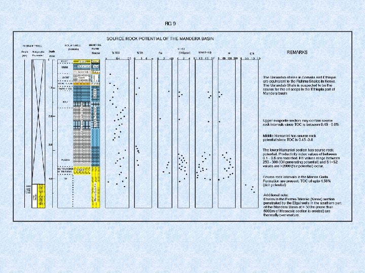
1. 1 Mandera basin v The Lamu Embayment’s northern bound is a triple junction with the Mandera basin to its North and the Anza basin to its North West. v Mandera basin bestrides Kenya, Ethiopia and Somalia. v The Kenyan portion of this basin covers an area of 51, 920 sq. Km and has a sediment thickness of up to 10 Km whose age ranges from Karoo equivalent (Upper Carboniferous to Lower Jurassic) up to Tertiary. v It is a failed Rift basin with a carbonate platform cap. The Petroleum System in Mandera basin is yet to be determined. v The only oil seep documented in Kenya to date occurs within this basin at Tarbaj # 1 well.
v This well established the presence of at least 200 m thick sand impregnated with tar. v This sand which is called the Mansa Guda Formation has reservoir rock potential since it has good porosity consisting of 5% free porosity plus 15% secondary porosity plugged with tar. v The tar has been established to be biodegraded asphalts and not pyrobitumen. v Other potential reservoir units are the Limestone beds overlying the Mansa Guda. v Mandera basin stratigraphy. v Source rock potential units are shales interbedded within the Mansa Guda Formation and overlying Limestone Formations as well as the Rahmu Shale which is an equivalent of Uarandab Shale that is considered to have sourced oil seeps in Ethiopia’s section of the Mandera.
1. 1 Anza basin v The Anza basin occurs to the Northwest of the Lamu Embayment. v It is part of the Central Africa Rift System, which crosses Africa linking the Atlantic, and Indian Oceans through Nigeria, Cameroon, Chad, Central Africa Republic, Sudan and Kenya. v Anza basin covers an area of about 94, 220 sq. Km and has isolated Jurassic but mainly Cretaceous to Tertiary aged sediments up to 10 Km deep. v It is a failed rift basin. v The Petroleum System in Anza basin is considered to be similar to that of the Muglad basin in Sudan.
v The current drilling results in Anza basin include recovery of oil and identification of potential source rocks. v During a Drill Stem Test of Sirius # 1 well in this basin, a paraffinic crude oil and natural gas were recovered from the depth intervals (4200 -4874 ft) 1281 -1284 m and (3860 -3870 ft) 1177 -1180 m. v The lithological column of Sirius # 1 well is representative of the stratigraphy of Anza basin. v Source rocks within the Upper Cretaceous and Lower Cretaceous intervals have been identified in Sirius # 1 and Ndovu # 1 wells respectively.
CENTRAL AFRICAN RIFT SYSTEM
GEOLOGICAL COLUMN OF SIRIUS # 1 WELL
SIRIUS # 1 The primary source rock is present at the following interval · 4910 -5900 ft (1500 -1800 m) Age: Upper Cretaceous Lithology: Shale Depositional Environment: Lacustrine TOC Rо HI Tmax - 1 -4% (good source richness) - 0. 8% - 0. 9% (inception of oil window) - 75 -400 (oil and gas prone) - 435˚C -445˚C (inception of oil window)
NDOVU # 1 Two source rocks are present at the following intervals: · 2650 -2700 M · 3000 -3200 M Interval: 2650 -2700 M Age: Lithology : Aptian – Albian (Lower Cretaceous) Dark grey shale, silty Depositional Environment: Deltaic and Lacustrine TOC - 1 -4% (good to excellent) H 1 - 50 -200 (gas prone) Rо - 0. 65 % (inception of oil window) PI - 0. 1 -0. 4 (oil window) Tmax - 44º-46ºс (oil window)
Interval: 3000 -3200 m Age: Barremian – Lower Aptian (Lower Cretaceous) Lithology: Dark grey shale, silty Enviro. Nment of deposition: Deltaic and Lacustrine TOC - 1 -6% (good to excellent) H 1 - 50 -200 (gas prone) Rо - 0. 74 -0. 85 % (oil window) PI - 0. 1 -0. 4 (oil window) Tmax - 44º-46ºс (oil window)
Comparison with equivalent interval from the Muglad Basin in Sudan (Source of information – Schull, 1988) Age of primary source rock: Cretaceous) Albian – Aptian (Lower Lithology: Dark grey shale Formation: Abu Gabra Fm. Depositional environment: Deltaic and Lacusrine TOC: 1 -5% (average 1. 3 a%) - Geothermal gradient: 26˚ C/km
1. 4 Tertiary Rift Valley v The fourth basin is the youngest geologically. This is the Tertiary Rift Valley. v It covers an area of about 38, 904 sq. Km. v The thickness of sediments in this basin is at least 3 Km as per current drilling results but could even be over 4 Km particularly in Lake Turkana. v This is an active rift basin evidently determined to be the Western bound of the currently seceding future continent of East Africa. v The sub-basins within the Tertiary Rift Valley are Lodwar South (Loperot), Lotikipi, Turkana, Suguta, Magadi, South Kerio and Nyanza. v The Petroleum System of the Tertiary Rift Valley is dependant on individual sub-basins. v Other than in Lodwar South (Loperot) sub-basin, the Systems in the other Sub-basins are yet to be deciphered.
v The System in Lodwar South Sub-basin (Loperot) evidently revolves around the proven Oligocene to Miocene Loperot Shale source rock. v Geological column encountered in Loperot # 1 well. v Two Loperot Shale source rock units have been delineated. v They are of Oligocene to Miocene age. v In Loperot # 1 well one of these source rocks is barely mature while the other one is highly mature. v The barely mature one is considered to have sourced the oil recovered during a drill stem test at the interval 952 -977 m. v Interbedded sands with porosities between 15 -40% are considered to be potential reservoir units if the right trapping configuration can be established.
GEOLOGICAL COLUMN OF LOPEROT # 1 WELL
The two Loperot shale source rocks: LOPEROT # 1 Two source rocks are present at the following intervals: · 1050 -1390 m · 2430 -2600 m Interval: 1050 – 1390 m Age: Lower Miocene Lithology: Shale Depositional Environment: Lacustrine TOC - 1 -17 % (excellent source richness) Rо - <0. 60 (at inception of maturity) S 2 - < 2 to > 10 (excellent source potential) HI - > 500 to > 500 (oil prone) Type 1(11) (Algal)
Interval: 2430 -2600 m Age: Oligocene – Lower Miocene Depth: Shale (partly Silty) Depositional Environment: Fluvial-Lacustrine TOC - 0. 2 -3. 3% (good source richness) Rо - 0. 7 – 1. 10 (mature to post mature) S 2 - 1 to 4 (fair source potential) HI - 80 – 120 (gas prone)
Hydrocarbon recoveries made in Loperot #1 Well. v From an RFT at 1110. 2, oil and water was recovered. This waxy oil of algal lacustrine origin with some land plant contribution. v Oil was collected from shakers while circulating at 1587 m. v Drill Stem Test # 2 conducted at the depth interval: 952977 m recovered oil while reverse circulating. v The Loperot Well proved the existence of two excellent source rocks in Lodwar South Sub-basin.
LEGAL AND FISCAL REGIMES v The Kenya Government Oil Sector Policy. v Procedures that Govern Oil Prospecting in Kenya.
The Kenya Government Oil Sector Policy v Petroleum Exploration and Production Legislation in Kenya was enacted in 1984 by Parliament and revised in 1986 to give incentives aimed at attracting International Oil Companies to invest and thus stimulate oil exploration in our country. v This legislation comprises of clauses that apply to all investors in the oil Exploration and Production Sector who have duly signed Production Sharing Contracts, popularly referred to as PSC, with the Government of Kenya.
The clauses that provide incentives are: - 1. The Customs and Excise Act which exempt investors from any payment of duties and taxes on all imported or re-exported materials and equipment for Petroleum Operations provided the Minister responsible for Energy or his representative has certified that the equipment and materials are to be used solely in Petroleum Operations. 2. The Exchange Control Act has been repealed and subsequently an Investor is allowed to open and operate foreign bank accounts, to retain abroad all proceeds from his Petroleum Operations not required to cover his liabilities in Kenya and to pay outside Kenya his expatriate employees and all goods and services necessary for the Petroleum Operations.
3. The Income Tax Act provides a specific method for computing the gains or profits of Petroleum Companies and the taxation of Petroleum Service sub-contractors and ensures that there is no double taxation for U. S. Companies and other Companies, which require such a protection. All these exemptions are done through the appropriate legal notices published by the Government as provided in the Model Production Sharing Contract.
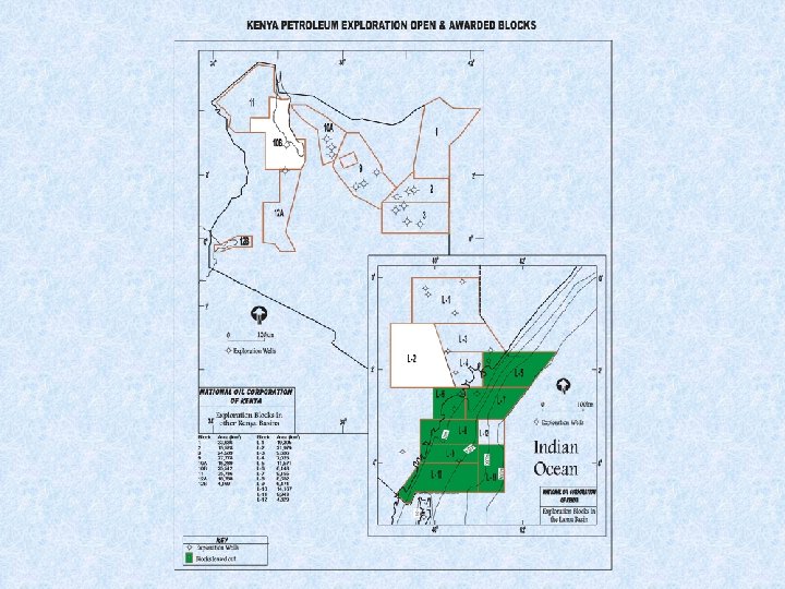
PROCEDURES THAT GOVERN OIL PROSPECTING IN KENYA v The Petroleum Exploration and Production Act that was enacted in 1984 and revised in 1986 regulates the negotiations and conclusions of Production Sharing Contracts with Potential Investors. v This Act together with its attendant Regulations provides the format and terms through which Petroleum Operations must be conducted. v A model Petroleum Agreement is used as a basing for negotiations with Potential Investors. This model, The Production Sharing Contract is included in the Petroleum Exploration and Production Act Regulations. v In pursuant of the provisions of this Act, the Government of Kenya has divided all areas available for exploration into Blocks. These are shown here on the map entitled ‘Kenya Petroleum Exploration Open and awarded Blocks. ’
v The significance of Petroleum to Kenya’s economy is demonstrated by the fact that in 1999, the Net Oil Imports cost the country Kshs. 29, 954. 8 million while the net export earnings from commodities was Ksh. 105, 976 million thereby meaning that 28. 3% was the ratio of the Net oil imports to net export earnings from commodities in 1999. v In the year 2000 the net oil imports costed the country Kshs. 53, 667 million while the net export earnings from commodities were worth Kshs. 109, 522. 3 million thereby showing that the ratio of cost of net oil imports to net export earnings from commodities was 49%. v This state of affairs is unfortunate and is one that the Government of Kenya is committed to do everything possible to redress and this is why investment in Petroleum Exploration in Kenya is of major interest to us.
NEGOTIABLE PROVISIONS IN THE PRODUCTION SHARING CONTRACTS IN FORCE IN KENYA. 1. TERM. • Initial Exploration Period • Additional Exploration Period Development Period 2. ACREAGE SURRENDER. • During Initial Exploration Period • During Additional Exploration Period 3. MINIMUM EXPLORATION WORK & EXPENDITURE OBLIGATIONS • Initial Exploration Period • Additional Exploration Period • Drilling Commitment 4. SURFACE FEES. • Calculated on basis of acreage 5. TRAINING FEES 6. TERMINATION CAUSES 7. COST RECOVERY 8. PRODUCTION SHARING
Procedure for applying for a Petroleum Exploration Block in Kenya Kindly signify your intention to negotiate for lease of a Petroleum Exploration Block by submitting your Production Sharing Contract (PSC) application to: The Minister for Energy, C/o Managing Director, National Oil Corporation of Kenya, Eland House, Kapiti Rd. , off Mombasa Rd. , P. O. Box 58567 - 00200 NAIROBI, KENYA. Fax: 254 -2 -606596 Email: mdnock@africaonline. co. ke In your application please specify the following: 1. The number of the Block to which the application applies; 2. The name of the applicant Company in full; 3. The nature of business of the applicant Company; 4. The place of incorporation; and 5. Evidence of the financial standing of the applicant Company as well as the technical qualifications of the Directors