Lake Origins and Morphology Lake Origins Lake Morphometry
 Fetch, Wind Waves")
 Tectonic Movements • Movement of tectonic plates has created some of")
 Volcanism: “Grew, Blew, Fell, Fill” * Caldera: A notable example is Crater Lake")
 Damming: * Natural processes can back-up the flow of water: - landslides -")
 Glacial activity: Glaciers may form a variety of lakes in the landscape following")

 Dissolution: Aggressive weathering of limestone bedrock can create sinkhole or cinote (typical in")


 depends")

 Wind causes water to move forward; underlying water rises to replace")
 Lake water can resonate in its basin under certain conditions of sustained")
- Slides: 16
Lake Origins and Morphology Lake Origins Lake Morphometry (shape and size) Fetch, Wind Waves & Mixing Langmuir Circulation & Seiches What’s a Lake? Bathymetry Map of Lake Erie: Isobaths are lines of constant depth; here they’re given at 1 m increments.
Lake Origins 1) Tectonic Movements • Movement of tectonic plates has created some of the oldest, deepest lakes on earth. • Graben, or rift, lakes form where faulting allows a block to slip down, causing a massive depression that fills with water. Horst lakes form similarly; however, the block tilts, or slips more severely on one side. • Uplift Lakes are due to epeirogeny, the rising of the large crustal blocks.
2) Volcanism: “Grew, Blew, Fell, Fill” * Caldera: A notable example is Crater Lake in Oregon. This was formed after Mt. Mazama erupted ~7700 yrs ago. The resulting collapse of the mountain walls left a deep crater that became filled with water. Residence time is very long!
3) Damming: * Natural processes can back-up the flow of water: - landslides - lava flows (coulee lakes) - animals constructed dams - thick vegetative growth (Sphagnum bogs) - glaciers (ice dams) * Manmade dams create reservoirs. Castor canadensis
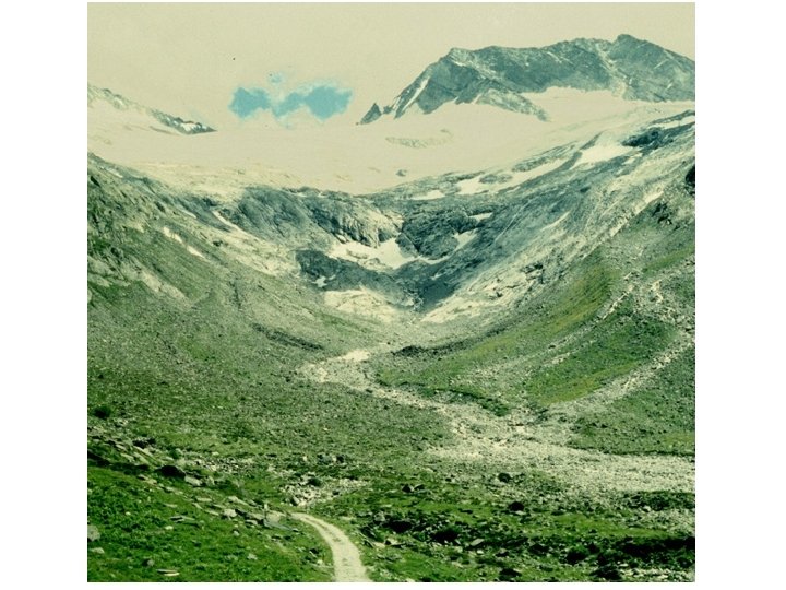
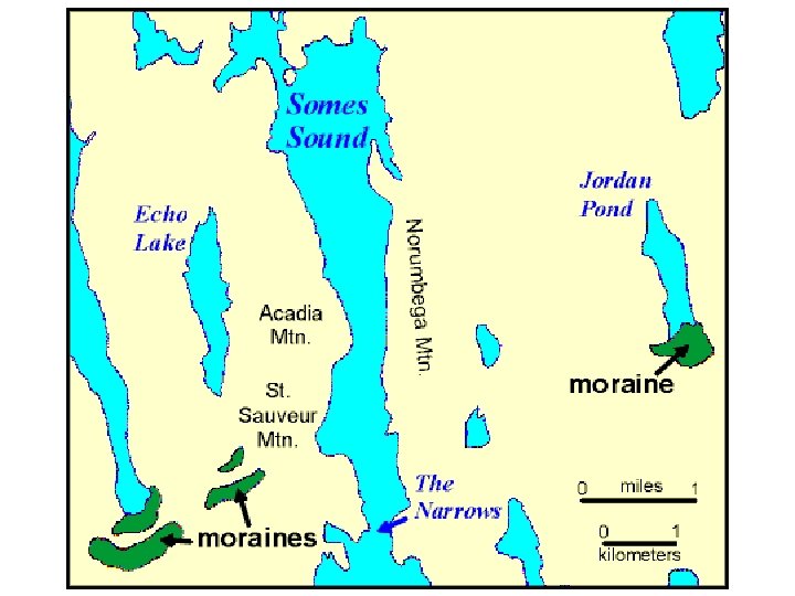
4) Glacial activity: Glaciers may form a variety of lakes in the landscape following their retreat (melting) up mountain valleys. Glaciers aggressively scour bedrock, creating depressions throughout mountain valleys, particularly at the “head” of a valley. - Cirque (valley head or “amphitheater”) - Paternoster (down valley; smaller) - Fjords (deeply scoured valleys) Glaciers move large amount of soils and rocky debris forward and to its sides as it flows (till; moraine). Much of this is entrained within the ice on the underside of the glacier. As the glacier retreats large deposits of moraine can accumulate; or chunks of ice can break off and becoming embedded into the till. - Terminal moraine lakes (wall of moraine builds at end) - Kettle (“prairie pothole”) lakes (melted ice chunks in till)
Glacial Lake Types
5) Dissolution: Aggressive weathering of limestone bedrock can create sinkhole or cinote (typical in karst topography) 6) Fluvial: River / stream flow dynamics (meanders, etc. ) can create fluvial lakes: - Oxbow lakes - Levee lakes 7) Aeolian: Scouring by abrasive forces of wind and sands - buffalo wallows - perched dune lakes 8) Cosmogenic: meteor impact craters.
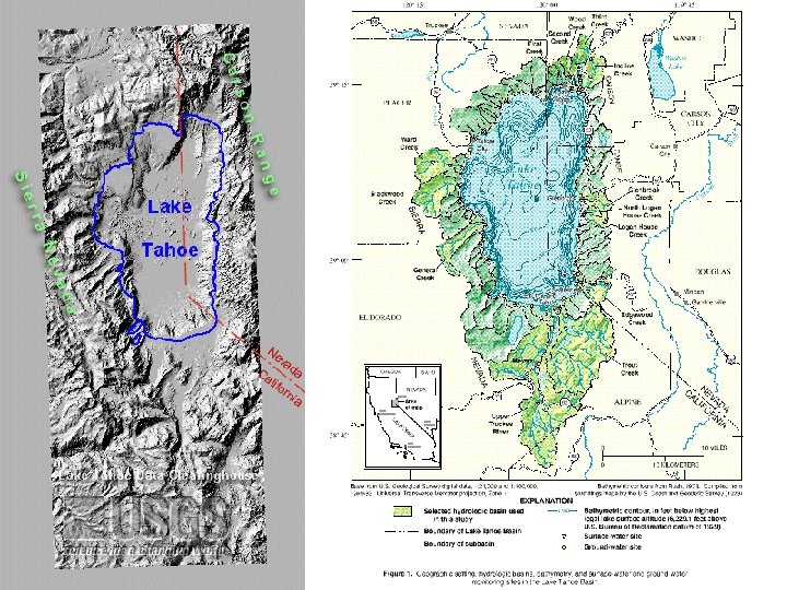
Morphometric Parameters • Surface Area: important in determining total incoming solar radiation; many parameters are reported in areal units (m-2). How can this be measured? • Depth (maximum depth; mean depth): lakes with low mean depth (shallow) are often more productive (why? ); the relative importance of littoral habitat can be determined by knowing depth at 1% surface irradiance (~3 * ZSD) • Volume: can be calculated from surface area and mean depth. If the amount of discharge into the lake from streams and other inputs (groundwater, direct runoff) is known then a retention time (residence time) may be calculated. Retention Time = (volume/discharge into lake) • Retention time may be from hours to thousands of years; useful in determining the impact of pollutants and relative influence of particular inputs (like a tributary). • Watershed Area: important influence on discharge into the lake; thereby retention time; larger watersheds also may contribute more nutrients, leading to greater productivity. • Shoreline Development (DL): irregularity or degree of convolutions of the shore.
DL = Length of lake shore divided by the circumference of a circle with equal surface area; DL = 1. 0 is a perfect circle. Reservoirs vs Natural Lakes: Reservoirs are dendritic in shape due to filling of stream channels. Very high DL value; ~ 4 -5. Overall, low mean depth, only deep area by dam. Watershed surface area very high relative to reservoir area. Trap nutrients and sediments. Productivity high (eutrophic). Benton Res. , TX Flathead L. , MT
Fetch, Wind Waves and Mixing Lake shape affects mixing: • Wave size (height) depends on: - Wind speed - Wind duration - Fetch • Fetch is the length of lake across which wind interacts at the water surface. Greater fetch; greater height. • Fetch will change with wind direction for most lakes; unless DL = 1. 0. • Watershed topography and vegetation cover can influence the “effective” fetch of a given lake. • What happens to epilimnion depth after deforestation around a lake?
Wind Waves, Lake Depth and Sediment Suspension • Wave mixing with depth can reach the lake bottom and suspend sediments. • Waves over a particular location can be classified based on wavelength (L) relative to water depth (z). - Deep-water wave - Shallow-water wave • Shallow-water wave behavior will suspend sediments and potentially release large stores of nutrients.
Langmuir Circulation (“Windrows”) Wind causes water to move forward; underlying water rises to replace it; the net effect is a spiral motion in the direction of the wind. For reasons, not completely understood, these “spiral circulation cells” will oppose each other in direction. Convergence and divergence zones are created; particles collect at convergences.
Seiche (sāsh) Lake water can resonate in its basin under certain conditions of sustained unidirectional winds followed by calm. The seiche may be externally visible or unseen, only in hypolimnion (internal seiche). Seiche cause entrainment (mixing) of layers.