WORLD GEOGRAPHY An Introduction Five Elements of Geography


- Slides: 35
WORLD GEOGRAPHY An Introduction
Five Elements of Geography The world in spatial terms- knowing location helps develop awareness of the world around you Places and Regions- place is location and characteristics (physical and cultural), regions are places united by common characteristics Physical Systems- what shapes the earth’s surface, plants, animals, climates Human Systems- how people shape the world, key theme is movement of goods, ideas, people Environment and Society- relationship between people and natural surroundings, how environment influences people and how people influence environment
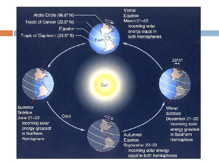
The Earth in Space Obvious Facts- third planet from sun in our solar system, layer of air surrounding earth called atmosphere (shields planet from harm), earth rotates on axis (one complete spin 24 hours), complete orbit around sun every 365. 25 days (to make up extra days we have leap year) Earth tilted on axis 23. 5 degrees, seasons change as earth revolves around sun, sunlight falls directly on earth in different places as it revolves around sun (direct rays= summer, indirect rays= winter)
Earth in Space Beginning of seasons June 21 - sun directly over Tropic of Cancer (north of equator) summer solstice December 22 - sun directly over Tropic of Capricorn (south of equator) winter solstice March 21 and September 23 – sun directly over equator, vernal and autumnal equinoxes
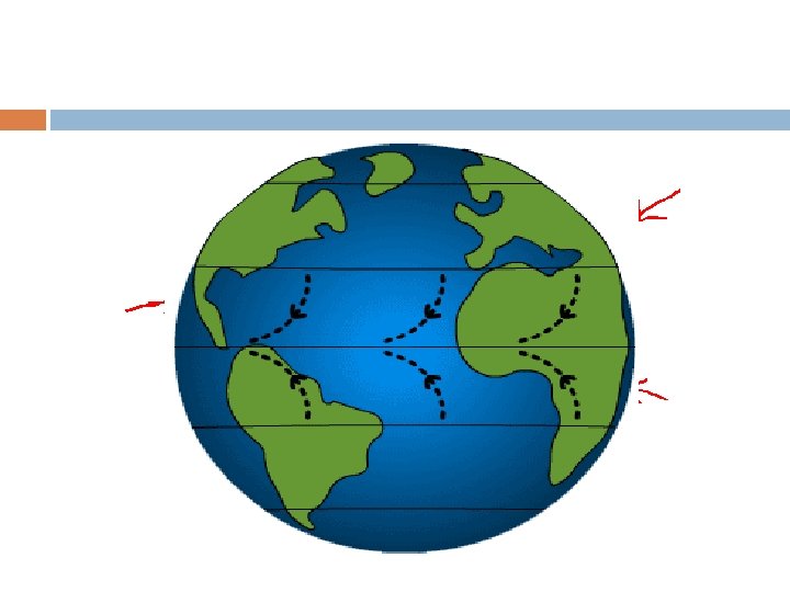
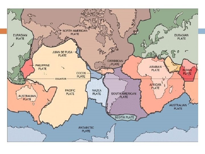
Forces that Shape the Earth constantly changing and being reformed Forces beneath the earth- plate tectonics theory used to explain earths structure Plates sit on top of liquid rock and often move in different directions Theory of plate movement known as continental drift When plates meet it causes earthquakes, push together to form mountains, when two plates slide next to each other it forms fault lines
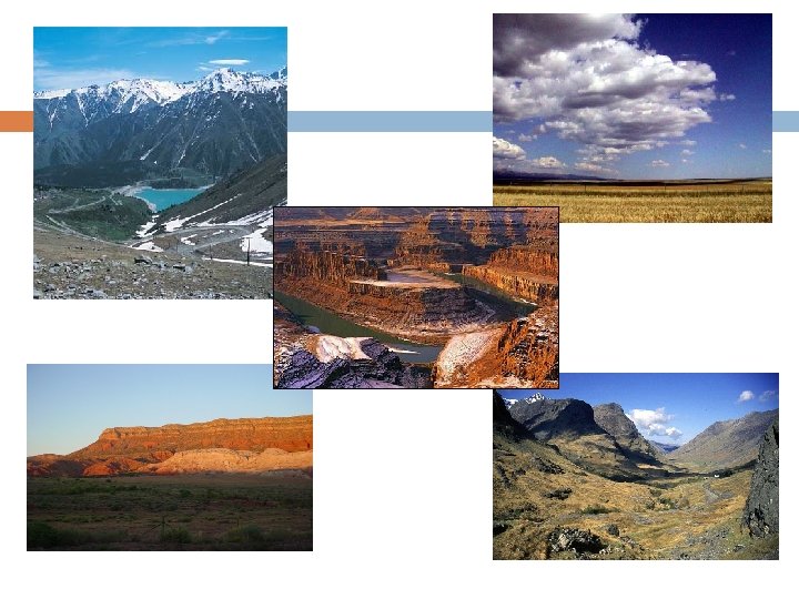
Forces that Shape the Earth To identify physical characteristics of the Earth geographers study landforms (individual features, mountains, valleys) Once land is formed through plate tectonics it is further shaped by weathering and erosion Weathering breaks surface rock down eventually into soil Water, frost, plants, chemicals Erosion- process of wearing away or removing weathered material Rivers cause erosion carry away soil Water, wind and ice weather material (rivers, glaciers)
Landforms and Waterways Mountains, hills, plateaus, plains, valleys, canyons What makes them different? Elevation (height above sea level) Plains- low lying areas of flat or gently rolling land Plateaus- higher elevation, some have steep cliffs, some flat areas surrounded by mountains Valleys- lie between mountains and hills Canyon- cut through plateaus cut by rivers
Other Landforms Some landforms defined by their relationship with water or larger land areas Isthmus- narrow piece of land that connects two larger pieces of land Peninsula- surrounded by water on three sides
Bodies of Water Strait- narrow bodies of water between two pieces of land Wider passage of land called a channel Mouth of river where it flows into larger body of water called a delta
Landforms in the Ocean Continental shelf- off the coast of each continent Plateau underwater, drops off steeply into deep ocean Tall mountains and deep valleys under ocean (deep valleys called trench) Deepest part of ocean called Mariana Trench in Pacific Ocean (over 35, 000 feet)
Earth’s Water 70% of Earth’s surface is water Can’t drink most of it (only 3%) Ocean’s largest bodies of water (97% of all water) Bays, seas, gulfs- smaller bodies of water (66 named) Total amount of water on earth does not change, water is constantly moving (water cycle)
Earth’s Water Only 3% of water on earth is freshwater and most of that is not available, most is frozen or trapped underground and held in aquifers Groundwater lies beneath earth’s surface Comes from rain, melted snow Wells and springs tap groundwater Many aquifers are drying up because of heavy human use, water becomes degraded Efforts being made to make saltwater potable, process is expensive, not energy efficient
Climates of the Earth
Weather and Climate Weather- day to day changes over a short period of time Climate- usual predictable pattern over a long period of time What causes climates to vary? Originally the sun, also latitude, winds, ocean currents, landforms and humans Latitude and Climate- part of earth-sun relationship Tropics- between 23. 5 degrees north and south of the equator sun’s rays hit directly on the earth Sun’s rays not as direct further south and north from this area Latitude north or south creates climates that follows general patterns Elevation influences climate Higher altitude has thinner air that holds less heat
Climate Wind and Climate Sun heats up surface of planet unevenly air moves across planet in typical prevailing patterns, distributes suns heat across planet Warm air near the equator moves toward poles, cold air from the poles moves toward equator Air moves from areas of high pressure to low pressure Earth rotates causes winds to curve Northern hemisphere winds blow clockwise, Southern Hemisphere blow counterclockwise known as the Coriolis Effect Monsoon- wind pattern blows over South Asia- dry in the winter and wet in the summer months
Climate Wind and Climate • Hurricanes- extreme tropical storms formed by seasonal winds blowing off coast of Africa that effect the western hemisphere • El Nino and La Ninacombination of temperature, wind and water changes in the Pacific off the coast of South America • El Nino-Pacific warms, more water evaporates, more clouds form, this changes wind and rain patterns in eastern Pacific • La Nina- water cools and it has effect on western Pacific
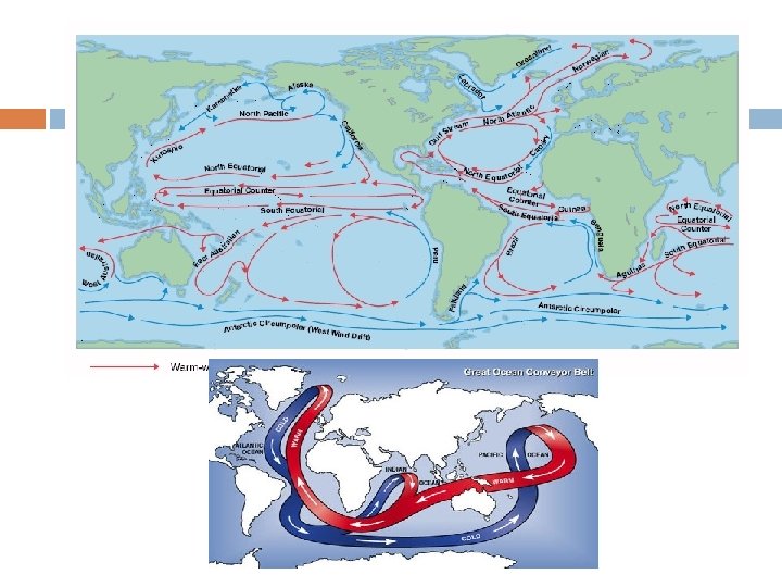
Climate Ocean Currents- streams of water carried across the globe Like wind warm water flows from near equator to cooler regions Cold water goes from the poles to warmer areas Currents effect climate of areas- Gulf Stream has effect on Western Europe Gulf Stream starts in Gulf of Mexico, moves across the Atlantic toward Europe Wind blows across the warm water and moderates climate of Western Europe
Climate Landforms and Climate Coasts moderated by oceans, less changeable weather Land effects climate, creates local winds Mountains effect rainfall, temperature Cooler air can’t hold as much moisture, warm moist air falls on windward side of mountain range, as it passes over the mountains the other side (leeward) is dry called the rain shadow effect
Climate Temperatures higher in cities Absorb more of the sun’s rays and cools off slower Called urban heat island effect Greenhouse effect- burning of fossil fuels releases gasses prevent heat from releasing into atmosphere (controversial) Clearing rainforests- burning forests releases gasses into air, trees hold moisture less water will evaporate and less rainfall occurs
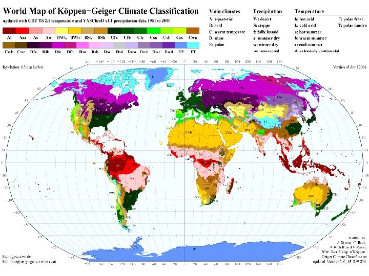
Climate Zones and Vegetation Tropical Climates- 23. 5 degrees north and south of equator, warm weather Tropical Rain Forest 100” of rain per year, lush vegetation, thick forests Tropical Savannawet/dry seasons, has broad grasslands called savannas
Climate Zones and Vegetation Midlatitude Climates- 23 -60 degrees north and south of equator Most of the worlds people live here Most varied region Results from mixture of air masses Marine West Coast Climatewinds from oceans, winters rainy and mild, variety of vegetation Mediterranean Climate- mild, rainy winters, hot, dry summers. Vegetation shrubs and short trees
Climate Zones and Vegetation Humid Conintential Climate- winters long, cold, snowy, short hot summers. Vegitation vast grasslands Humid Subtropical Climate- rain all year, hot, humid summers, winters short and mild
Climate Zones and Vegetation High Latitude Climates • 60 degrees north/south to the poles, generally cold • Subarctic Climate- low population density, huge evergreen forests called taiga • Tundra Climate- vast treeless plains, harsh and dry. Lower layers of soil permanently frozen (permafrost). In summer soil turns marshy. Few trees, grass and shrubs
Climate Zones and Vegetation High Latitude Climates Ice Cap Climate- bitterly cold, lichens and moss only vegetation Dry Climates Little rainfall, hot days, cool nights (can also have cold winters) can be found at any latitude Desert Climate- less than 10” of rain per yr. , scattered scrub plants Steppe Climate- partially dry grasslands, bushes, short grasses cover this zone
Highland Climate ü Found in all climate zones ü Timberline- elevation where trees do not grow
Environmental Balance Humans have settled on all types of landforms Climate, availability of food, water, resources cause people to settle in particular areas Four parts of earth’s physical geography, humans can have a huge effect on these systems Atmosphere, lithosphere, hydrosphere, biosphere Atmosphere can be effected by humans through pollution Example- Acid Rain, pollutants combine with precipitation. It can destroy forests, buildings
Environmental Balance Lithosphere Earth’s hard outer shell, land areas Topsoil- vital part, if not managed can be eroded and degraded quickly Deforestation- cutting down trees, another way topsoil can be lost How can humans protect topsoil?
Environmental Balance Hydrosphere- Limited supply Water Management- conservation most effective technique Irrigation for crops wasteful, most water evaporates Chemicals, pesticides, industrial processes degrade and pollute water supplies
Environmental Balance Biosphere- increase in human population encroaches on ecosystems, reduces biodiversity