World Geography What Is Geography Geography study of


 Ø Key Terms Ø Latitude – measures distance north")


 • • Low latitude » 0º – 30º")


- Slides: 25
World Geography
What Is Geography? ►Geography: study of our planet’s surface and the processes that shape it § Links physical sciences with social sciences § Geo (earth) graphy (write) is a Greek word meaning “to describe the Earth. ”
• Humans posses an awareness of and curiosity about the distinctive character of places. – We can think territorially or spatially. – Places possess an emotional quality and significance that contribute profoundly to our identity as individual human beings (Sense of Place).
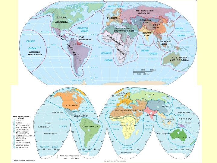
WORLD GEOGRAPHIC REGIONS • Geographic regions change over time. • Where geographic realms meet, transition zones, not sharp boundaries, mark their contacts.
• A place has both physical structure and cultural content. - The characteristics of places develop and change over time. - Places may be generalized into regions of similarities and differences.
Characteristics of Regions • Regions - are groupings of like places with characteristics that set them apart and make it substantially different from surrounding areas. • Regions have location - Europe, Latin America, East Asia, and Oceania. • Regions have boundaries - boundaries are drawn where those features no longer occur or dominate.
We will focus primarily on the Cultural, Political, Economic, Physical Population of the world’s realms and regions.
Atlas Introduction Latitude and Longitude Goode’s Atlas page XII
Basic Earth Properties (page XII) Ø Key Terms Ø Latitude – measures distance north and south of the equator (also known as parallels). Ø Equator – the half way point between the north and south poles (is the longest line of latitude) Ø Longitude - measures distance east and west of the Prime Meridian Ø Prime Meridian – is a line of longitude that measures east and west. This is where time begins. Ø International Dateline 180 degrees (the day begins)
• Geographic grid – Graticule ; the network of lines of latitude and longitude upon which a map is drawn – Parallels and meridians 11
Latitude
• Latitude – North-south location, 0º-90º, Degrees, minutes, seconds – Parallels 13
– Seven significant latitudes – Fig. 1 -13 and 14 14
• Longitude – East-west location, 0º-180º – Degrees, minutes, seconds – Meridians – Fig. 1 -16 15
– Regions on Earth (Latitude bands) • • Low latitude » 0º – 30º N and S Mid latitude » 30º – 60º N and S High latitude » 60º – 90º N and S Equatorial » within a few degrees of the equator Tropical » within the tropics between 23. 5º N and 23. 5º S Subtropical » 25º – 30º N and S Polar » within a few degrees of the North and South Pole 16
Geographers’ Visual Tools ►Cartography: the skill/art of depicting geographic information § Scale: Relationship between distance on map and actual distance on earth § Title: Subject of map § Caption: Features the cartographer wants you to notice § Legend: Explanation of symbols and colors
Geographers’ Visual Tools ►Map Projections § Render spherical earth on flat surface § Always distorted ►Sample projections § Mercator § Goode’s interrupted homolosine § Robinson
Map Projections
Map Projections
Map Projections
Q: Which has the higher IQ, latitude or longitude? A: Longitude; it's got 360 degrees!
London 51°N 0° New York 41°N 74°W St. Louis 39°N 90°W
Q: Where is it always 90 degrees, but never hot? A: The North and South Poles