Weather Prediction Center 2015 NCEP Production Suite Review

- Slides: 15

Weather Prediction Center 2015 NCEP Production Suite Review December 7, 2015 Mark Klein Science and Operations Officer Contributions by David Novak, Kathy Gilbert, Patrick Burke, Tony Fracasso, Rich Otto, Marc Chanard, and Mike Bodner

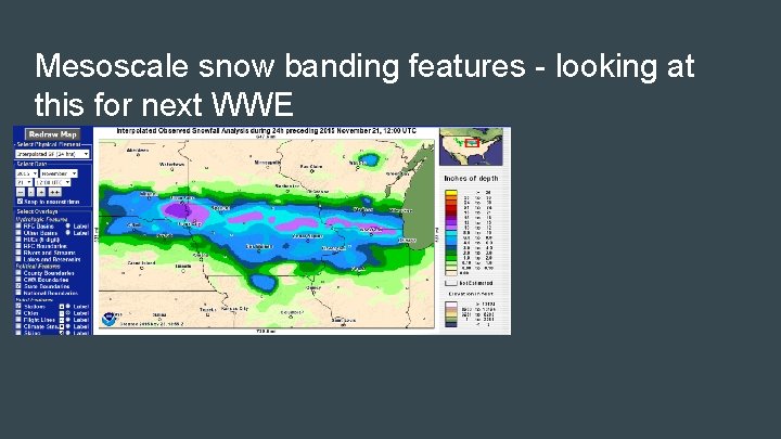
What are WPC’s biggest challenges? QPF NWP QPFs have shown very slow improvement for the last decade Forecasting placement of high-impact precipitation events, particularly in the warm season Medium range Under-dispersive ensemble guidance (GEFS) Winter weather Prediction of precipitation type and snowfall accumulations in transition zones Mesoscale snow banding Mining relevant information from an expansive model suite

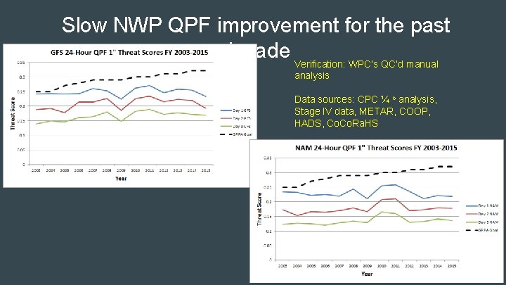
Slow NWP QPF improvement for the past decade Verification: WPC’s QC’d manual analysis Data sources: CPC ¼ o analysis, Stage IV data, METAR, COOP, HADS, Co. Ra. HS

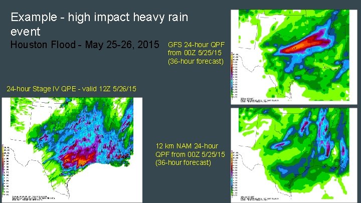
Example - high impact heavy rain event Houston Flood - May 25 -26, 2015 GFS 24 -hour QPF from 00 Z 5/25/15 (36 -hour forecast) 24 -hour Stage IV QPE - valid 12 Z 5/26/15 12 km NAM 24 -hour QPF from 00 Z 5/25/15 (36 -hour forecast)

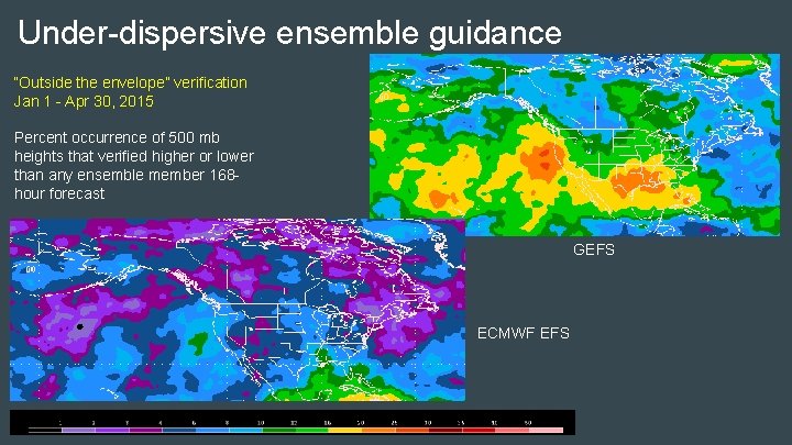
Under-dispersive ensemble guidance “Outside the envelope” verification Jan 1 - Apr 30, 2015 Percent occurrence of 500 mb heights that verified higher or lower than any ensemble member 168 hour forecast GEFS ECMWF EFS

Does the current production suite and products adequately help you address those challenges? To some extent, yes! Convection-allowing models (CAMs) have become an invaluable tool for our QPF and Metwatch functions Looking forward to increasing use of the HREF But… Lack of model improvement at QPF hinders ability to accurately predict high-impact events with adequate lead time Under-dispersive ensemble guidance leads to over-confidence and an over-forecast bias in our probabilistic QPF and winter weather forecasts Use of precipitation-type algorithms is outdated Easy-to-digest training materials/documentation on models does not exist; for example:

Is the current amount of available guidance too much, too little, or the right amount? The quality of the guidance matters more than the amount Does the NWP help the forecaster make the right key decision as fast as possible? Generally endorse the “Di. Mego plan” - consolidation of the model suite into 3 -4 ensemble systems GEFS SREF HREF Includes HRRR, Hi. Res windows, NAM nest Run hourly with hourly (or sub-hourly) output to 18 -24 hours

What does WPC need in terms of products or models to address challenges over next 1 -2 years? Advancements to the quality of existing product suite Improve QPF Increasing role in IDSS for high-impact precipitation events Promote greater ensemble dispersion in both the SREF and GEFS SREF is a primary driver for our PQPF and PWPF Other improvements Add probabilistic forecasts of precipitation types over time intervals (1 -h , 3 -h depending on frequency of data output)

What does WPC need in terms of products or models to address challenges over next 1 -2 years? Additional post-processing QPF Probability matched mean QPF from GEFS, SREF, HREF Improve intensity forecasts while maintaining the forecast spatial extent of the precipitation Medium range Ensemble cluster output Winter Weather Expand the use of POFP in deterministic/ensemble systems. Additional probabilistic output from ensemble guidance Neighborhood probability fields from ensembles

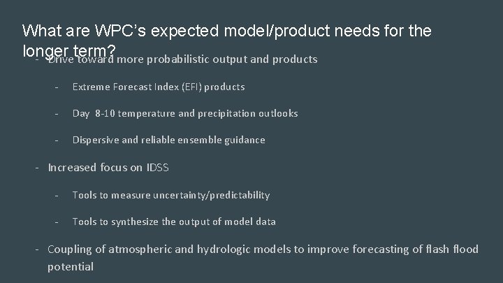
What are WPC’s expected model/product needs for the longer - Driveterm? toward more probabilistic output and products - Extreme Forecast Index (EFI) products - Day 8 -10 temperature and precipitation outlooks - Dispersive and reliable ensemble guidance - Increased focus on IDSS - Tools to measure uncertainty/predictability - Tools to synthesize the output of model data - Coupling of atmospheric and hydrologic models to improve forecasting of flash flood potential

Extra Slides

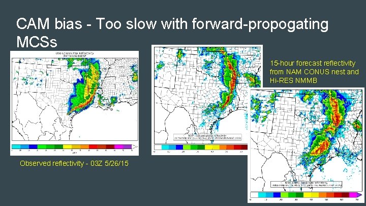
CAM bias - Too slow with forward-propogating MCSs 15 -hour forecast reflectivity from NAM CONUS nest and Hi-RES NMMB Observed reflectivity - 03 Z 5/26/15

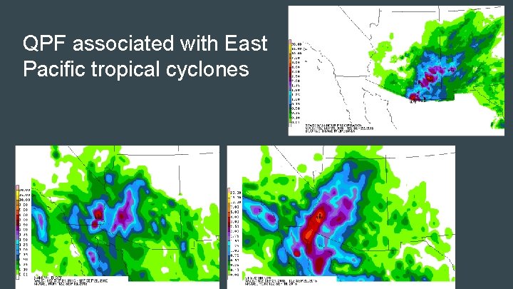
QPF associated with East Pacific tropical cyclones

Subjective observed model biases NAM, GFS, and to a lesser extent the Hires Windows, displacing heaviest QPF too far to the north/west away from the best instability during the warm season During events with strong synoptic forcing (cool season), the Hi. Res Windows have a wet bias in the cool sector due to over-forecast of CAPE. CAM guidance tends to be slow with forward-propagating convective systems Warm low-level temperature bias in the HRRR allows this model to break the cap too soon; initiates convection too early NAM CONUS nest has a high bias with precipitation maxima, but coverage is

Mesoscale snow banding features - looking at this for next WWE