TC Intensity Estimation SATellite CONsensus SATCON Derrick Herndon





- Slides: 25
TC Intensity Estimation: SATellite CONsensus (SATCON) Derrick Herndon and Chris Velden University of Wisconsin - Madison Cooperative Institute for Meteorological Satellite Studies Interdepartmental Hurricane Conference Savannah, GA 01 -04 March 2010 Research supported by the ONR Marine Meteorology and Atmospheric Effects Program
Motivation • Importance of getting current TC intensity right - Intensification trends > forecasts - Predictor for statistical forecast models - Climatology (Basin Best Tracks) - Initial conditions for numerical models • Contemporary methods to estimate TC intensity can vary by more than 40 knots • Several objective TC intensity methods exist, but the goal of SATCON is to assist forecasters in assessing current intensity by combining the confident aspects of the individual objective estimates into a single “best” estimate
Motivation
Motivation
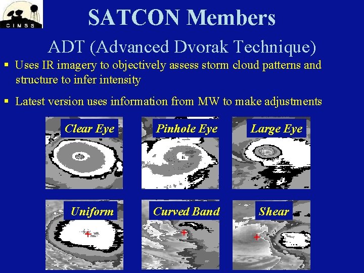
SATCON Members ADT (Advanced Dvorak Technique) § Uses IR imagery to objectively assess storm cloud patterns and structure to infer intensity § Latest version uses information from MW to make adjustments Clear Eye Pinhole Eye Large Eye Uniform Curved Band Shear
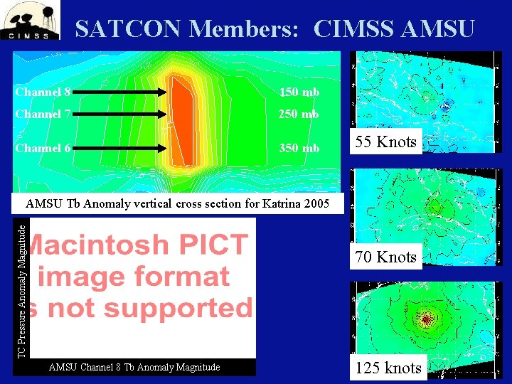
SATCON Members: CIMSS AMSU Channel 8 150 mb Channel 7 250 mb Channel 6 350 mb 55 Knots TC Pressure Anomaly Magnitude AMSU Tb Anomaly vertical cross section for Katrina 2005 70 Knots AMSU Channel 8 Tb Anomaly Magnitude 125 knots
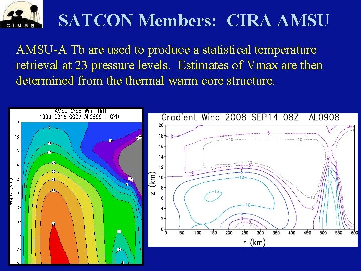
SATCON Members: CIRA AMSU-A Tb are used to produce a statistical temperature retrieval at 23 pressure levels. Estimates of Vmax are then determined from thermal warm core structure. IR image from NRL TC Page
SATCON The strengths and weaknesses of each method are assessed based on statistical analysis, and that knowledge is used to assign weights to each method in the consensus algorithm based on situational performance to arrive at a single intensity estimate
Another component of SATCON is crossmethod information sharing • What relationships might exist between the parameters of the member algorithms? • Can some of the unique information from these parameters be shared between the algorithms to improve the individual members? • Corrections can be made to improve the performance of each algorithm, then the weights re-derived to produce an improved weighted consensus
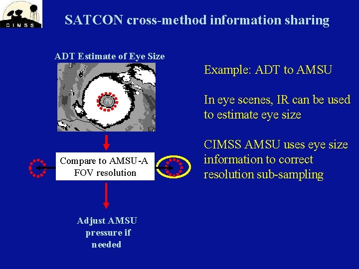
SATCON cross-method information sharing ADT Estimate of Eye Size Example: ADT to AMSU In eye scenes, IR can be used to estimate eye size Compare to AMSU-A FOV resolution Adjust AMSU pressure if needed CIMSS AMSU uses eye size information to correct resolution sub-sampling
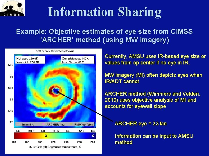
Information Sharing Example: Objective estimates of eye size from CIMSS ‘ARCHER’ method (using MW imagery) Currently, AMSU uses IR-based eye size or values from op center if no eye in IR. MW imagery (MI) often depicts eyes when IR/ADT cannot ARCHER method (Wimmers and Velden, 2010) uses objective analysis of MI and accounts for eyewall slope ARCHER eye = 33 km Information can be input to AMSU method
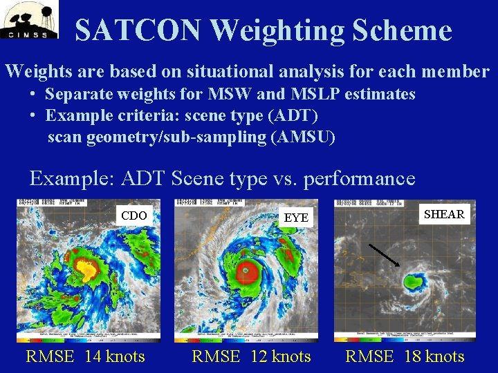
SATCON Weighting Scheme Weights are based on situational analysis for each member • Separate weights for MSW and MSLP estimates • Example criteria: scene type (ADT) scan geometry/sub-sampling (AMSU) Example: ADT Scene type vs. performance CDO EYE SHEAR RMSE 14 knots RMSE 12 knots RMSE 18 knots
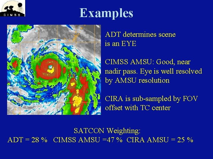
Examples ADT determines scene is an EYE CIMSS AMSU: Good, near nadir pass. Eye is well resolved by AMSU resolution CIRA is sub-sampled by FOV offset with TC center SATCON Weighting: ADT = 28 % CIMSS AMSU =47 % CIRA AMSU = 25 %
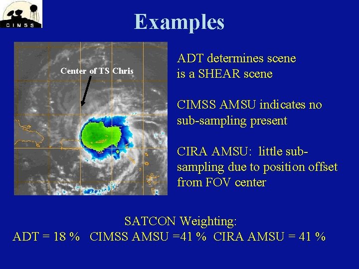
Examples Center of TS Chris ADT determines scene is a SHEAR scene CIMSS AMSU indicates no sub-sampling present CIRA AMSU: little subsampling due to position offset from FOV center SATCON Weighting: ADT = 18 % CIMSS AMSU =41 % CIRA AMSU = 41 %
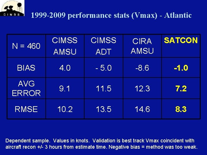
1999 -2009 performance stats (Vmax) - Atlantic N = 460 CIMSS AMSU CIMSS ADT CIRA AMSU SATCON BIAS 4. 0 - 5. 0 -8. 6 -1. 0 AVG ERROR 9. 1 11. 5 12. 3 7. 2 RMSE 10. 2 13. 5 14. 6 8. 3 Dependent sample. Values in knots. Validation is best track Vmax coincident with aircraft recon +/- 3 hours from estimate time. Negative bias = method was too weak.
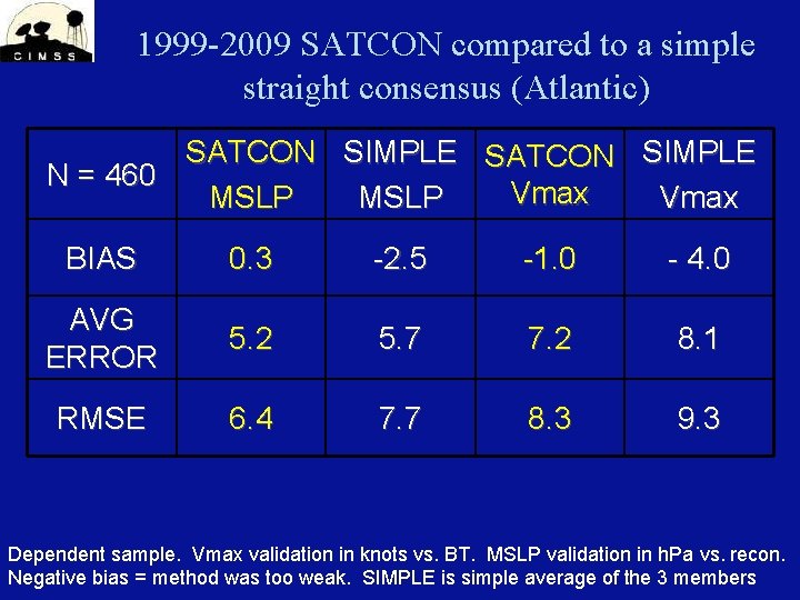
1999 -2009 SATCON compared to a simple straight consensus (Atlantic) SATCON SIMPLE N = 460 Vmax MSLP Vmax BIAS 0. 3 -2. 5 -1. 0 - 4. 0 AVG ERROR 5. 2 5. 7 7. 2 8. 1 RMSE 6. 4 7. 7 8. 3 9. 3 Dependent sample. Vmax validation in knots vs. BT. MSLP validation in h. Pa vs. recon. Negative bias = method was too weak. SIMPLE is simple average of the 3 members
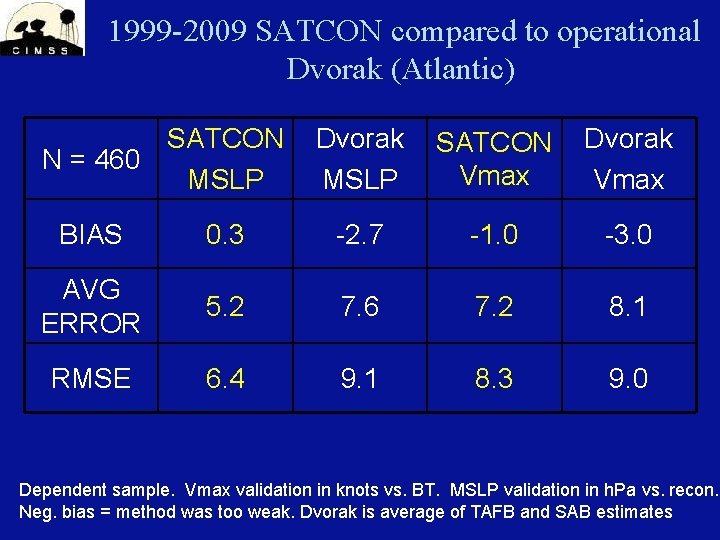
1999 -2009 SATCON compared to operational Dvorak (Atlantic) SATCON N = 460 MSLP Dvorak MSLP SATCON Vmax Dvorak Vmax BIAS 0. 3 -2. 7 -1. 0 -3. 0 AVG ERROR 5. 2 7. 6 7. 2 8. 1 RMSE 6. 4 9. 1 8. 3 9. 0 Dependent sample. Vmax validation in knots vs. BT. MSLP validation in h. Pa vs. recon. Neg. bias = method was too weak. Dvorak is average of TAFB and SAB estimates
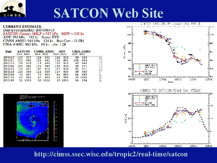
SATCON Web Site http: //cimss. ssec. wisc. edu/tropic 2/real-time/satcon
Summary A weighted consensus of three objective satellite-based methods to estimate TC intensity (SATCON) shows skill compared to conventional Dvorak-based methods. Independent trials during 2008 and 2009 in the Atlantic support the dependent sample results. SATCON also showed skill vs. other methods in the West. Pac during TPARC/TCS-08 in 2008 (small sample of validated cases). SATCON is run experimentally on all global TCs in real-time, with the information available on the CIMSS TC web site.
References Brueske K. and C. Velden 2003: Satellite-Based Tropical Cyclone Intensity Estimation Using the NOAA-KLM Series Advanced Microwave Sounding Unit (AMSU). Monthly Weather Review Volume 131, Issue 4 (April 2003) pp. 687– 697 Demuth J. and M. De. Maria, 2004: Evaluation of Advanced Microwave Sounding Unit Tropical. Cyclone Intensity and Size Estimation Algorithms. Journal of Applied Meteorology Volume 43, Issue 2 (February 2004) pp. 282– 296 Herndon D. and C. Velden, 2004: Upgrades to the UW-CIMSS AMSU-based TC intensity algorithm. Preprints, 26 th Conference on Hurricanes and Tropical Meteorology, Miami, FL, Amer. Meteor. Soc. , 118 -119 Olander T. and C. Velden 2007: The Advanced Dvorak Technique: Continued Development of an Objective Scheme to Estimate Tropical Cyclone Intensity Using Geostationary Infrared Satellite Imagery. Wea. and Forecasting Volume 22, Issue 2 (April 2007) pp. 287– 298 Velden C. et al. , 2006: The Dvorak Tropical Cyclone Intensity Estimation Technique: A Satellite. Based Method that Has Endured for over 30 Years. Bulletin of the American Meteorological Society Volume 87, Issue 9 (September 2006) pp. 1195– 1210 Wimmers, A. , and C. Velden, 2010: Objectively determining the rotational center of tropical cyclones in passive microwave satellite imagery. Submitted to JAMC.
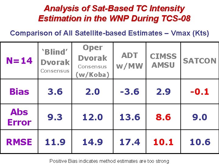
Analysis of Sat-Based TC Intensity Estimation in the WNP During TCS-08 Comparison of All Satellite-based Estimates – Vmax (Kts) N=14 ‘Blind’ Dvorak Consensus Oper Dvorak Consensus ADT CIMSS SATCON AMSU w/MW (w/Koba) Bias 3. 6 2. 0 -3. 6 2. 9 -0. 1 Abs Error 9. 3 12. 0 13. 6 8. 6 9. 0 RMSE 11. 9 14. 9 17. 4 10. 1 10. 6 Positive Bias indicates method estimates are too strong
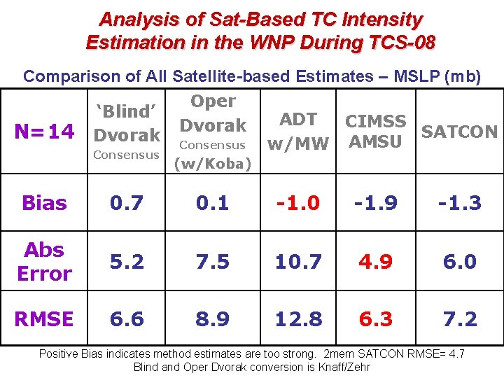
Analysis of Sat-Based TC Intensity Estimation in the WNP During TCS-08 Comparison of All Satellite-based Estimates – MSLP (mb) N=14 ‘Blind’ Dvorak Consensus Oper Dvorak Consensus ADT CIMSS SATCON AMSU w/MW (w/Koba) Bias 0. 7 0. 1 -1. 0 -1. 9 -1. 3 Abs Error 5. 2 7. 5 10. 7 4. 9 6. 0 RMSE 6. 6 8. 9 12. 8 6. 3 7. 2 Positive Bias indicates method estimates are too strong. 2 mem SATCON RMSE= 4. 7 Blind and Oper Dvorak conversion is Knaff/Zehr