Surveying Introduction Surveying is the art of determining


,")


- Slides: 13
Surveying – Introduction Surveying is the art of determining the relative positions of different objects on the surface and below the surface of the earth by measuring the horizontal and vertical distances between them and by preparing a map to any suitable scale. Thus in discipline, the measurements are taken in the horizontal plane alone.
Objective of surveying The aim of surveying is to prepare a plan or map to show the relative positions of the objects on the surface of the earth. The map is drawn to some suitable scale. It shows the natural features of a country such as towns, villages, roads, railways, rivers, etc. Maps may also include details of different engineering works, such as roads, railways, irrigation, canals, etc.
Uses of surveying • Surveying may be used for the following various applications. • To prepare a topographical map which shows the hills, valleys, rivers, villages, towns, forests , etc. of a country. • To prepare a cadastral map showing the boundaries of fields, houses, and other properties. • To prepare an engineering map showing details of engineering works such as roads, railways, reservoirs, irrigation canals, etc. • To prepare a military map showing the road and railway communications with different parts of a country. Such a map also shows the different strategic points important for the defence of a country.
• To prepare a contour map to determine the capacity of reservoir and to find the best possible route for roads, railways, etc. • To prepare a geological map showing areas including underground resources exist. To prepare an archeological map including places where ancient relics exist.
GENERAL PRINCIPLE OF SURVEYING • The general principles of surveying are: 1. To work from the whole to the part, and 2. To locate a new station by at least two measurements (linear or angular) from fixed reference points. • According to the first principle, the whole area is first enclosed by main stations (i. e. controlling stations) and main survey lines (i. e. controlling lines). The area is then divided into a number of parts by forming well conditioned triangles. A nearly equilateral triangle is considered to be the best well-conditioned triangle. The main survey lines are measured very accurately with a standard chain. Then the sides of the triangles are measured. The purpose of this process of working is to prevent accumulation of error. During this procedure, if there is any error in the measurement of any side of a triangle, then it will not affect the whole work. The error can always be detected and eliminated.
• But, if the reverse process (i. e. from the part to the whole) is followed, then the minor errors in measurement will be magnified in the process of expansion and stage will come when these errors will become absolutely uncontrollable. • According to the second principle, the new stations should always be fixed by at least two measurements (linear or angular) from fixed reference points. Linear measurements refer to horizontal distances measured by chain or tape. Angular measurements refer to the magnetic bearing or horizontal angle taken by a prismatic compass or theodolite.
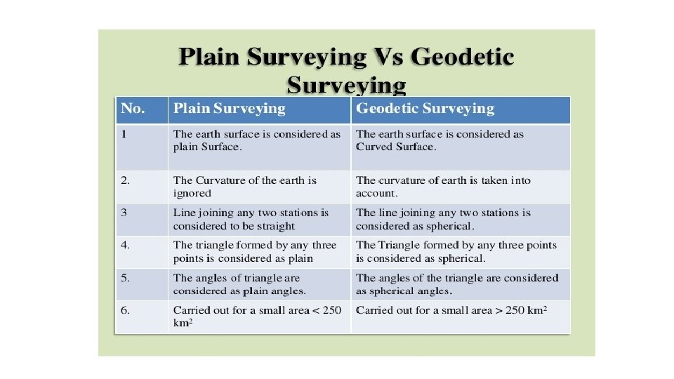
CLASSIFICATION OF SURVEYING Generally, surveying is divided into two major categories: plane and geodetic surveying. • PLANE SURVEYING • Geodetic surveying
Classifications of Surveying • Based on the purpose (for which surveying is being conducted), Surveying has been classified into: • Control surveying : To establish horizontal and vertical positions of control points. • Land surveying : To determine the boundaries and areas of parcels of land, also known as property survey, boundary survey or cadastral survey. • Topographic survey : To prepare a plan/ map of a region which includes natural as well as and man-made features including elevation.
• Engineering survey : To collect requisite data for planning, design and execution of engineering projects. Three broad steps are 1)Reconnaissance survey : • To explore site conditions and availability of infrastructures. 2)Preliminary survey : • To collect adequate data to prepare plan/map of area to be used for planning and design. 3)Location survey : • To set out work on the ground for actual construction/execution of the project.
Route survey : • To plan, design, and laying out of route such as highways, railways, canals, pipelines, and other linear projects. Construction surveys : • Surveys which are required for establishment of points, lines, grades, and for staking out engineering works (after the plans have been prepared and the structural design has been done). Astronomic surveys : • To determine the latitude, longitude (of the observation station) and azimuth (of a line through observation station) from astronomical observation. Mine surveys : • To carry out surveying specific for opencast and underground mining purposes
SPECIAL SURVEYS As mentioned earlier in this chapter, SPECIAL SURVEYS are conducted for a specific purpose and with a special type of surveying equipment and methods. A brief discussion of some of the special surveys familiar to you follows. • LAND SURVEYS (sometimes called cadastral or property surveys) are conducted to establish the exact location, boundaries, or subdivision of a tract of land in any specified area. This type of survey requires professional registration in all states.
• CONTROL SURVEYS Provide "basic control" or horizontal and vertical positions of points to which supplementary surveys are adjusted. These types of surveys (sometimes termed and traverse stations and the elevations of bench marks. These control points are further used as References for hydrographic surveys of the coastal waters; for topographic control; and for the control of many state, city, and private surveys.