Surveying Surveying Surveying has traditionally been defined as

Surveying

Surveying Surveying, has traditionally been defined as the science, art, and technology of determining the relative positions of points above, on, or beneath the Earth’s surface, or of establishing such points. Surveying can be regarded as that discipline that encompasses all methods for measuring and collecting information about the physical Earth and our environment, processing that information, and disseminating a variety of resulting products to a wide range of clients.

Tasks of surveyors The determination of the size and shape of the earth and the measurements of all data needed to define the size, position, shape and contour of any part of the earth and monitoring any change therein. The positioning of objects in space and time as well as the positioning and monitoring of physical features, structures and engineering works on, above or below the surface of the earth. The development, testing and calibration of sensors, instruments and systems for the abovementioned purposes and for other surveying purposes. The acquisition and use of spatial information from close range, aerial and satellite imagery and the automation of these processes. The determination of the position of the boundaries of public or private land, including national and international boundaries, and the registration of those lands with the appropriate authorities. The design, establishment, and administration of geographic information systems (GIS), and the collection, storage, analysis, management, display and dissemination of data. The analysis, interpretation, and integration of spatial objects and phenomena in GIS, including the visualization and communication of such data in maps, models and mobile digital devices. The planning, measurement and management of construction works, including the estimation of costs.

Principles of levelling

Testing for collimations errors

Curvature of the level surface
 • With horizontal auxiliary triangle")
Tower height determination • Vertical auxiliary triangle ( one-sided) • With horizontal auxiliary triangle elevation • With levelling • Reflector prism • Angle measurement : Each 3 times with full sets

Trigonometric heightening

Vertical Triangle Method Given Height of H_KA, H_KB Measured: b, Zenith angles Z_A and Z_B

Horizontal Triangle Method

Horizontal Triangle Method Given Height of H_KA, H_KB Measured: b, Horizontal angles, and And Zenith angles : Z_A and Z_B

Horizontal Triangle Methods Error analysis calculations formula : Knowing the accuracy of the instrument you have used

Geodetic Computations

Conventional Control Surveys

Conventional Control Surveys

Polar and Rectangular Coordinates
 Clockwise interior angles (angles to the right). (b) Counterclockwise")
Angles, Azimuths, and Bearings (a) Clockwise interior angles (angles to the right). (b) Counterclockwise interior angles ( angles to the left). Azimuths. Deflection angles. Bearing angles.
 and Bearing")
Computation of Azimuths (from North) and Bearing

Azimuth Quadrants Since the arctan - function is only uniquely defined in the first quadrant (0 – 90 ) the azimuth in other quadrants needs additional information, i. e. the positive/negative Δx or Δy, to identify the correct azimuth.

Coordinates from Measurements

Intersection by Angles: Example

Intersection by Distances: Example

Resection This involves the angular measurement from P out to the known points A, B, C. It is an extremely useful technique for quickly fixing position where it is best required for setting-out purposes.

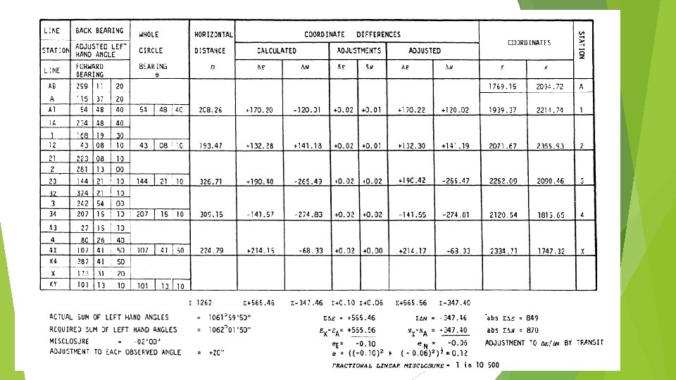
Traverse

Distribution of the Misclosure

Worked Examples: Traversing

Worked Examples: Traversing

Link Traverse

Least Squares Adjustment-Distance Observation Equation

Least Squares Adjustment-Direction and Angle Observation Equation

Computation Procedure Compute approximate coordinates Calculate ‘computed’ distances and bearings between provisional positions Set up one observation equation for each observation Weight observations equations Form normal equations - tabular method, matrix algebra Solve for corrections - d. N, d. E Add corrections to the approximate coordinates …… to give final coordinates Iterate
- Slides: 32