Starter Can you name any river features landforms


- Slides: 47
Starter Can you name any river features / landforms?
Lesson three b: Landforms Learning intention: We are learning about river processes in the hydrosphere. Success criteria: • I can explain, with the aid of a diagram, the processes involved in erosion of rivers and the transportation of materials with the use of diagrams.
River Processes
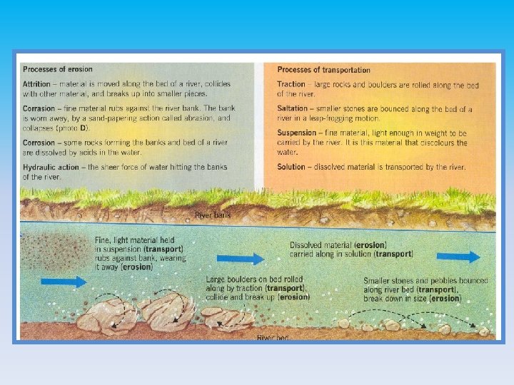
What is erosion? This is the wearing away and removal of the material loosened by weathering. Weathering and erosion work together!
What are the agents of erosion? Physical agents: Rivers - they wear the banks and bed of their channel Ice - when a glacier (tongue of moving ice) moves down a valley it uses the material it carries with it to wear away the valley bottom and sides Sea - coastlines are under constant attack by waves Wind - in the dry deserts the wind picks up tiny particles of sand blast them against anything that is in the way Human agents: Bulldozers and lorries can dig out and move large amounts of soil and loose rocks, so changing the landscape People also remove trees and vegetation which can allow water, wind and ice to erode land more easily
Make a copy on A 4 paper of the diagram below: Tributary Neighbouring Mouth Drainage watershed drainage Source basin Confluence basin
Lesson three b: Landforms Learning intention: We are learning about the three courses of a river and the landforms associated with the upper course. Success criteria: • I can explain, with the aid of a diagram, the formation of features in the upper course of a river. .
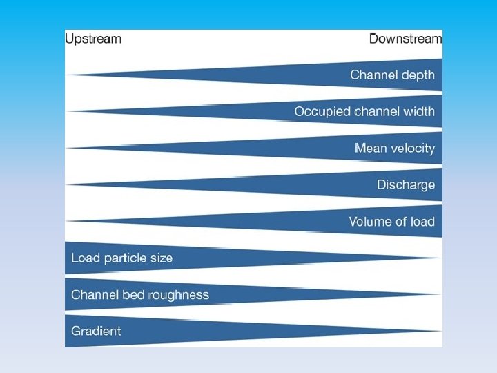
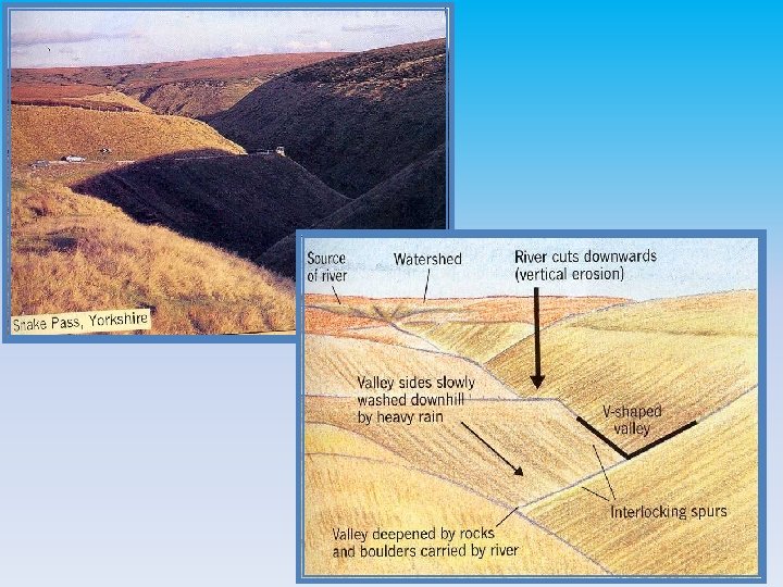
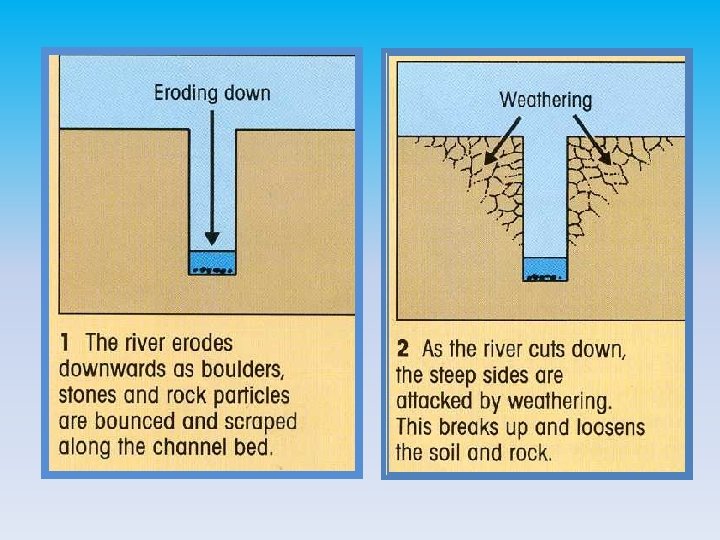
Upper Course: This is the section of the river nearest the source. This is where load is biggest and most erosion is vertical. Most landforms are made by erosion and include; waterfalls, gorges, rapids, vshaped valleys and interlocking spurs Middle Course: This is the section when the river leaves the mountains and enters are more hilly environment. The valley floors starts to widen as you get more horizontal erosion. The landforms that you get in the middle course include alluvial fans and meanders. Lower Course: This is the section closest to the mouth. Here the river is travelling over much flatter land the load is much smaller and smoother. This is more horizontal erosion here as the river nears its base level. The landforms you find in the lower course include meanders, oxbow lakes, braided rivers, levees and deltas.
Upper valley characteristics “V”shaped valley, vertical erosion dominant Interlocking spurs Slumping and landslides very active hill slopes Narrow, shallow channel, low velocity and discharge Large bed load derived from upstream and from valley sides
River load in upper course Boulders are large, angular and/or semi-rounded, due to attrition within the load and abrasion with the stream bed and banks
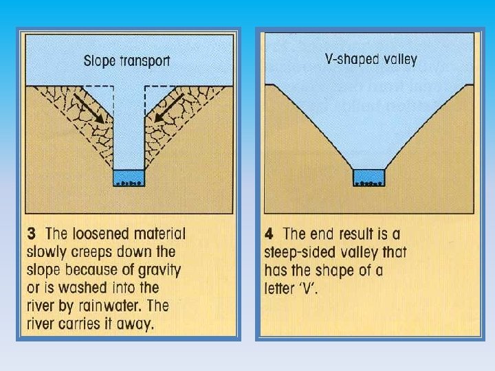
Upper course - V-Shaped valley
Upper course - Waterfall
High Force waterfall, R. Tees Waterfall creates a gorge as it recedes upstream by eroding the base and neck Plunge pool
Waterfall formation
Formation of a waterfall
Task: Past paper question With the aid of a diagram, explain the formation of a waterfall 8 Hint: give examples of rock types and include processes of erosion
Perfect Answer Waterfalls are found where hard rock such as limestone overlies softer rock such as mudstone . The water is powerful and erodes the softer rock by hydraulic action (the sheer force of the water hitting off the rock) . A plunge pool forms. The softer rock is worn away and the hard rock is undercut . And an overhang of hard rock is left suspended above the plunge pool . This collapses as there is nothing to support it and the rock falls into the plunge pool . Rock fragments swirling around deepen the plunge pool by the process of abrasion, where rocks carried by the river rub against the rock wearing it away in a sandpaper action . This process is repeated over a long period of time and the waterfall retreats upstream leaving a steep-sided gorge . A good example of this can be found at High Force on the River Tees .
The diagram With the aid of a diagram, explain the formation of a waterfall 8
Close-up of potholes
Lesson three b: Landforms Learning intention: We are learning about the three courses of a river and the landforms associated with the upper course. Success criteria: • I can explain, with the aid of a diagram, the formation of features in the middle course of a river. .
Middle course - Meanders
Formation of Meanders Line of maximum velocity - the ‘thalweg’
Point bar deposits
Point Bar Deposits Point bar deposits grows laterally through time
Meander, R. Lavant, Chichester Thalweg Floodplain River Cliff Slip-off slope or River beach Point bar deposits on the inner meander bend where there is low energy
Incised meander on the R. Colorado
Incised meanders – Colorado plateau
Migrating meanders What are the signs that the meanders are moving downstream?
Lesson three b: Landforms Learning intention: We are learning about the three courses of a river and the landforms associated with the upper course. Success criteria: • I can explain, with the aid of a diagram, the formation of features in the lower course of a river. .
Lower course – Ox-bow lakes
Task – Past Paper Question 10 minutes • Ox-bow lakes are common features in the lower course of a river. Explain, with the aid of a diagram or diagrams, how an oxbow lake is formed. . (5)
Perfect Answer The water flows faster on the outside bend of a river meander so erodes the banks by the processes of hydraulic action (the sheer force of the water hitting the banks) and by abrasion (where fine materials rubbing against the banks act like sandpaper) causing the banks to become steeper Deposition takes place on the inside bend of a meander where the water is shallower and moving more slowly. It has less energy here. . Over time the neck of the meander becomes more incised and bends back on itself, leaving a very narrow piece of land . During a storm or prolonged period of rain when the river is more powerful, it cuts through the narrow neck and takes a new, straighter route . Deposition takes place, leaving the old meander cut off, and an oxbow lake is formed . This feature can fill up with sediment and dry out, only filling up after heavy rain .
Lower course – flood plains
Lower course – levees
Lower course - Delta • A river delta is a landform that forms from deposition of sediment carried by a river as the flow leaves its mouth and enters slower-moving or stagnant water. • This occurs where a river enters an ocean, sea, estuary, lake, reservoir, or (more rarely) another river that cannot carry away the supplied sediment.
Delta
Lower course - Estuary • An estuary is a partially enclosed coastal body of brackish water with one or more rivers or streams flowing into it, and with a free connection to the open sea. Estuaries form a transition zone between river environments and maritime environments.
Estuary
Estuary / Delta – the difference • An estuary is a body of water, while a delta is a landmass. • Estuaries are places where the river meets the ocean. Deltas are formed by the accumulation of sediments borne by the river.
Summary of valley characteristics Course Feature Upper Interlocking spurs ‘v’ shaped valley Waterfall gorge Middle Wider valley Gentler sloping sides meanders Lower Widest part of valley Floodplain Levees Ox bow lakes Delta Estuary
Success criteria ü I can explain the features of a river in the upper, middle and lower courses with the use of diagrams
Plenary What processes are involved in the formation of river cliffs and beaches?