Overview of acid mine drainage impacts in the


 14 9 8 7 Baking Soda Distilled Water 6. 5 -8.")


 Contaminated groundwater flow •")
 Post Mining • Recharge of karst aquifer with contaminated")

")
")

")


- Slides: 18
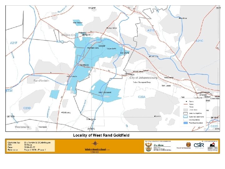
Overview of acid mine drainage impacts in the West Rand Goldfield Presentation to the Director General of DWAF: 2 February 2009 PRESENTED BY : DATE: TEL: E-MAIL:
2. 5 Ml Courtesy of Phil Hobbs - CSIR
x 10 = 25 Ml/d TDS load ~ 100 t/d Treat. cost R 5 M/m West Rand Basin
WITWATERSRAND BASIN x 100 = 250 Ml/d
p. H (Logarithmic) 14 9 8 7 Baking Soda Distilled Water 6. 5 -8. 4 6 Acid 5 4 6. 0 -9. 0 Orange Juice 3 Vinegar 2 Lemon Juice 1 0 7. 0 -8. 0 Battery Acid Typical Wits Acid Mine Drainage 10 Aquatic Ecosystem (Site Specific) 11 Ammonia Irrigation 12 Bleach Drinking Water Alkaline 13 DWAF Guidelines 2. 5 -4
Pre mining situation • • Before mining, the water table will have followed a natural piezometric surface Springs may have developed in areas where this surface lies above ground level and where suitable conduits exist by which water can flow to surface Diagram modified after: Hobbs, P. J. and Cobbing, J. E. (2007) A hydrogeological assessment of acid mine drainage impacts in the West Rand Basin, Gauteng Province, CSIR/THRIP, CSIR/NRE/WR/ER/2007/0097/C, Pretoria: 59 p.
During active mining phase Groundwater flow would have been drawn into the mine void owing to dewatering and the creation of a cone of depresion During Mining • • Zone of AMD generation AMD pumped from workings During mining, dewatering will have lowered the water table within the mine and surrounding areas Springs will have dried up in the area affected by dewatering Diagram modified after: Hobbs, P. J. and Cobbing, J. E. (2007) A hydrogeological assessment of acid mine drainage impacts in the West Rand Basin, Gauteng Province, CSIR/THRIP, CSIR/NRE/WR/ER/2007/0097/C, Pretoria: 59 p.
Post mining situation Post Mining AMD decanting from low-lying shaft(s) Contaminated groundwater flow • • Water will tend to return to the pre-mining piezometric surface, although this is likely to be flat (or flatter) due to the higher transmissivity of the mined out voids Water will decant from mine openings or other conduits where these lie below the piezometric surface Diagram modified after: Hobbs, P. J. and Cobbing, J. E. (2007) A hydrogeological assessment of acid mine drainage impacts in the West Rand Basin, Gauteng Province, CSIR/THRIP, CSIR/NRE/WR/ER/2007/0097/C, Pretoria: 59 p.
Downstream groundwater pollution Treatment plant(s) Post Mining • Recharge of karst aquifer with contaminated surface water Discharge of partially treated water Polluted water discharged to the Tweelopie Spruit recharges the Zwartkrans Compartment, leading to contamination of substantial karst groundwater resources and as yet poorly determined impacts on the Cradle of Humankind World Heritage Site Diagram modified after: Hobbs, P. J. and Cobbing, J. E. (2007) A hydrogeological assessment of acid mine drainage impacts in the West Rand Basin, Gauteng Province, CSIR/THRIP, CSIR/NRE/WR/ER/2007/0097/C, Pretoria: 59 p.
Water pollution management via maintenance of water levels at the ECL Level which will prevent decant of mine water to surface via shafts and springs Level which will protect local and regional groundwater • • • This situation may be managed via maintenance of water levels at the Environmental Critical Level (ECL), defined as that level where contaminated mine water will not impact on the environment. The ECL for surface water has been identified for the West Rand only. Additional groundwater investigations are required to determine the appropriate level for groundwater protection however it is estimated to be 100 -150 m below the surface water ECL level. ECLs have not been determined precisely for the other goldfields although there is a good conceptual understanding of issues, particularly in the Central Rand. Diagram modified after: Hobbs, P. J. and Cobbing, J. E. (2007) A hydrogeological assessment of acid mine drainage impacts in the West Rand Basin, Gauteng Province, CSIR/THRIP, CSIR/NRE/WR/ER/2007/0097/C, Pretoria: 59 p.
p. H (Water discharged to the Krugersdorp Game Reserve)
Electrical Conductivity (Water discharged to the Krugersdorp Game Reserve)
Events: January-March 2008 Low p. H water released after period of rainfall • No significant change in conductivity • “High rainfall” period similar to normal years
Downstream groundwater quality (Krugersdorp Brickworks Borehole)
Volumes and loads • Polluted water is discharged into a receiving environment – Volume = ~25 Ml/d – Salt content = ~4 g/l – Salt load = ~100 tons per day 20 t • • 20 t 20 t Dilution by around 5 Ml/d from springs, much of it also contaminated, leading to little dilution This high salinity has had impacts on drinking water quality downstream and has been proposed as the cause of animal deaths and health effects in the Krugersdorp Game Reserve
Regional Closure Strategy • • • Regional Closure Strategies have been developed by the DME in partnership with CGS, CSIR and Mintek. Acknowledge the underground interconnection of mines, leading to cumulative and integrated impacts on the environment and society, with multiple mines responsible for impacts within regions Key aspects – Addresses water management, dust, radioactivity, ground instability, land sterilisation and socioeconomic aspects – Water management by integration within the mining industry and other liable parties – Environmental protection can be ensured by the pumping of water to lower the mine void water level to the ECL and treating of water to a standard suitable for discharge (Stock Watering standard or better because of the proximity of the Krugersdorp Game Reserve) or sale to a third party – Establishment of closure and monitoring committees to ensure meaningful stakeholder interactions and to maintain technical oversight of the process. This has already partially been achieved via the Technical Working Group and Monitoring Committee – Apportionment studies found that ALL mines in the Western Basin who had or currently have rights to mine are jointly and severally liable (for example East Champ D’Or is listed as a asset on DRDGold shareholder publications).
Conclusions • Pollution is as a result of current and historical mining activities which created and exposed contamination sources connected to an artificial aquifer within a natural groundwater system: – Ingress of water into the mine void – Flooding and decant of contaminated water is driven by natural processes – “Shutting down the mine” won’t work! • • Enforce the “polluter-pays” principle Ensure that water volume, quality and pollution load issues are adequately captured in all EMPs and Water Use Licenses Enforce legislation to promote the development and implementation of short, medium and long-term solutions Ensure meaningful involvement of stakeholders