National Aeronautics and Space Administration The Role of
- Slides: 23

National Aeronautics and Space Administration The Role of Remote Sensing in Disaster Management Presented by John Zuzek NASA Headquarters Remote Sensing Workshop 20 -21 March 2006 www. nasa. gov 1

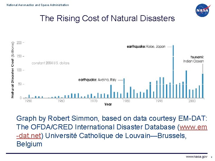
National Aeronautics and Space Administration The Rising Cost of Natural Disasters Graph by Robert Simmon, based on data courtesy EM-DAT: The OFDA/CRED International Disaster Database (www. em -dat. net) Université Catholique de Louvain—Brussels, Belgium www. nasa. gov 2

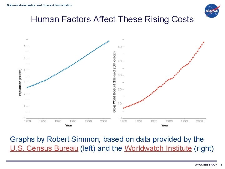
National Aeronautics and Space Administration Human Factors Affect These Rising Costs Graphs by Robert Simmon, based on data provided by the U. S. Census Bureau (left) and the Worldwatch Institute (right) www. nasa. gov 3

National Aeronautics and Space Administration Uses of Remote Sensing in Disaster Management • Hazard and risk modeling of tsunamis, hurricanes, earthquakes and disease pandemics • Models of extreme oceanic, land atmospheric phenomena as well as pandemic outbreaks • Remote sensing based early warning systems for natural disasters such as tsunamis, hurricanes, earthquakes, floods, etc. • Satellite and/or airborne observations of extreme natural events in support of disaster response • Damage assessment using satellites and airborne sensors • Damage and loss estimation www. nasa. gov 4

National Aeronautics and Space Administration Hurricane Katrina (August 2005) • Began as tropical depression in central Bahamas afternoon of 23 August 2005. Made landfall along SE coast of Florida evening of 25 th as Category 1 hurricane. • Regained hurricane status after emerging into Gulf of Mexico, becoming Category 1 storm morning of 26 th of August. Conditions in Gulf were favorable for Katrina to intensify. • Evening of 26 th, Katrina was Category 2 storm and continued to move slowly W-SW in southeastern Gulf of Mexico. • Morning of 27 th, Katrina became Category 3 storm with maximum sustained winds of 100 knots (115 mph). www. nasa. gov 5

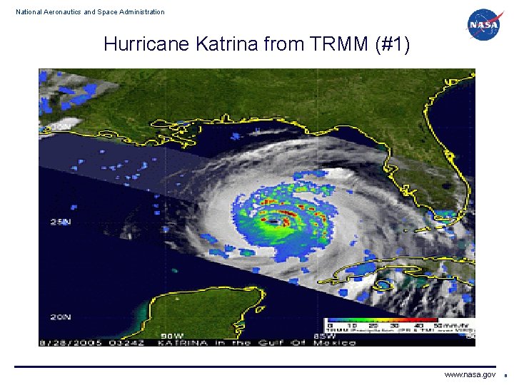
National Aeronautics and Space Administration Hurricane Katrina from TRMM (#1) www. nasa. gov 6

National Aeronautics and Space Administration Hurricane Katrina from TRMM (#1) Caption • This first image was taken at 03: 24 UTC 28 August 2005 (11: 24 pm EDT 27 August) just as Katrina was about to become a Category 4 hurricane in the central Gulf of Mexico. The image reveals the horizontal distribution of rain intensity within Katrina as obtained from TRMM's sensors. Rain rates in the central portion of the swath are from TRMM Precipitation Radar (PR). PR is able to provide fine resolution rainfall data and details on the storm's vertical structure. Rain rates in the outer swath are from the TRMM Microwave Imager (TMI). The rain rates are overlaid on infrared (IR) data from the TRMM Visible Infrared Scanner (VIRS). TRMM reveals that Katrina has a closed eye surrounded by concentric rings of heavy rain (red areas) that are associated with outer rain bands. www. nasa. gov 7

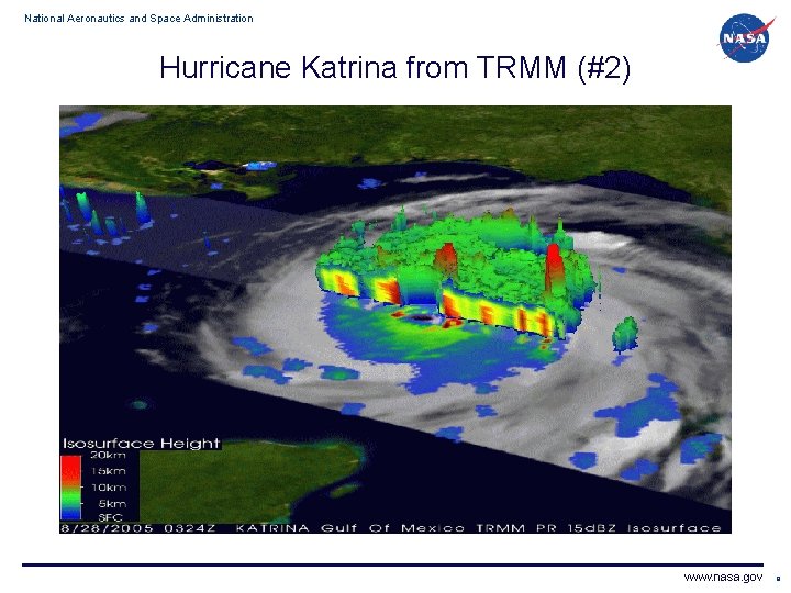
National Aeronautics and Space Administration Hurricane Katrina from TRMM (#2) www. nasa. gov 8

National Aeronautics and Space Administration Hurricane Katrina from TRMM (#2) Caption • The second image was taken at the same time as the first image and shows a 3 D perspective of Katrina with a cut-away view through the eye of the storm. The vertical height is determined by the height of precipitation-sized particles as measured by the TRMM PR. Two isolated tall towers (in red) are visible: one in an outer rain band the other in the northeastern part of the eyewall. This area of deep convection in the eyewall is associated with the area of intense rainfall in the eyewall. The height of the eyewall tower is 16 km. Towers this tall near the core are often an indication of intensification as was true with Katrina, which became a Category 4 storm soon after this image was taken. www. nasa. gov 9

National Aeronautics and Space Administration Hurricane Katrina from TRMM (#3) www. nasa. gov 10

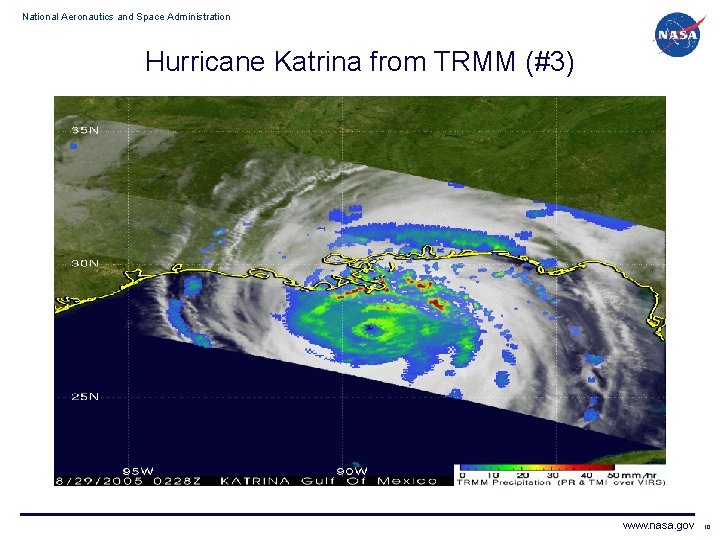
National Aeronautics and Space Administration Hurricane Katrina from TRMM (#3) Caption • The final image was taken at 02: 29 UTC August 29 th (9: 29 pm CDT August 28). The center of Katrina does not fall within the PR swath in this image. However, the large eye of the storm is clearly visible using TMI by the large ring of moderate intensity rain, (green annulus). The first outer rain bands with embedded areas of heavy rain (red areas) are already impacting the coast in southeastern Louisiana. At the time of this image, Katrina was at Category 5 intensity with maximum sustained winds measured at 140 knots (161 mph) by NHC. Katrina initially made landfall at 6: 10 am CDT along the Mississippi delta as a strong Category 4 storm. (TRMM Imagery by NASA/JAXA) www. nasa. gov 11

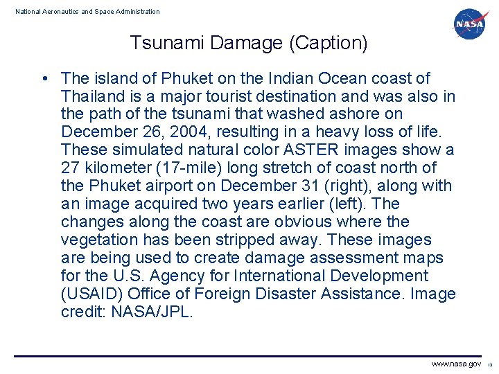
National Aeronautics and Space Administration Tsunami Damage (December 2004) www. nasa. gov 12

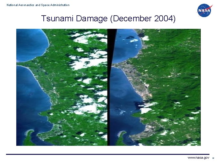
National Aeronautics and Space Administration Tsunami Damage (Caption) • The island of Phuket on the Indian Ocean coast of Thailand is a major tourist destination and was also in the path of the tsunami that washed ashore on December 26, 2004, resulting in a heavy loss of life. These simulated natural color ASTER images show a 27 kilometer (17 -mile) long stretch of coast north of the Phuket airport on December 31 (right), along with an image acquired two years earlier (left). The changes along the coast are obvious where the vegetation has been stripped away. These images are being used to create damage assessment maps for the U. S. Agency for International Development (USAID) Office of Foreign Disaster Assistance. Image credit: NASA/JPL. www. nasa. gov 13

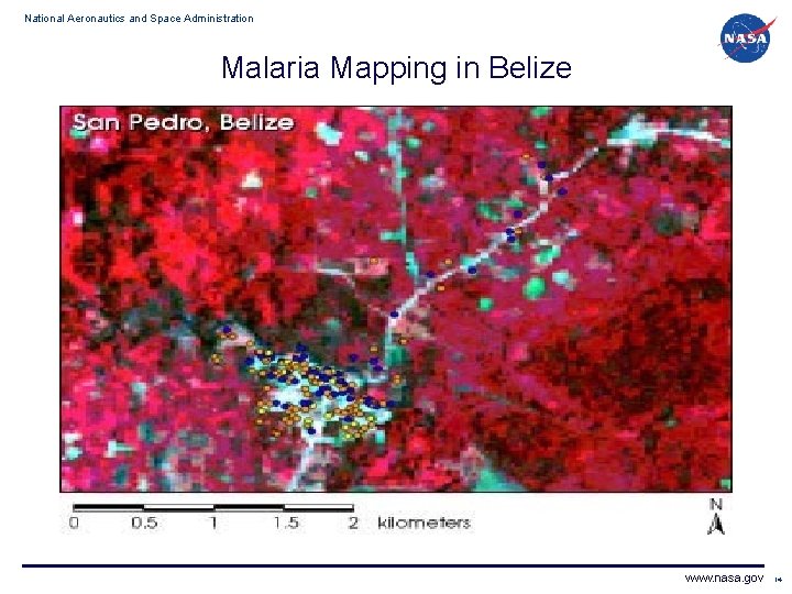
National Aeronautics and Space Administration Malaria Mapping in Belize www. nasa. gov 14

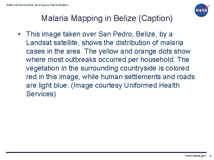
National Aeronautics and Space Administration Malaria Mapping in Belize (Caption) • This image taken over San Pedro, Belize, by a Landsat satellite, shows the distribution of malaria cases in the area. The yellow and orange dots show where most outbreaks occurred per household. The vegetation in the surrounding countryside is colored in this image, while human settlements and roads are light blue. (Image courtesy Uniformed Health Services) www. nasa. gov 15

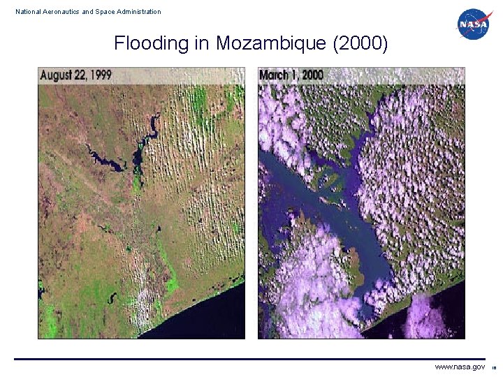
National Aeronautics and Space Administration Flooding in Mozambique (2000) www. nasa. gov 16

National Aeronautics and Space Administration Flooding in Mozambique (Caption) • This pair of images from Landsat 7 shows the incredible amount of flooding that occurred in March of 2000 in Mozambique. A month of rains and two cyclones caused the Limpopo River to swell to 80 km wide in places. Several hundred people were killed, and over a million were forced from their homes. (Image courtesy of NASA) www. nasa. gov 17

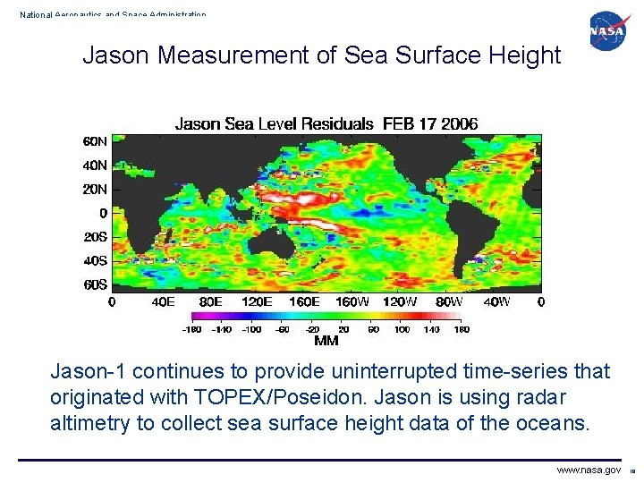
National Aeronautics and Space Administration Jason Measurement of Sea Surface Height Jason-1 continues to provide uninterrupted time-series that originated with TOPEX/Poseidon. Jason is using radar altimetry to collect sea surface height data of the oceans. www. nasa. gov 18

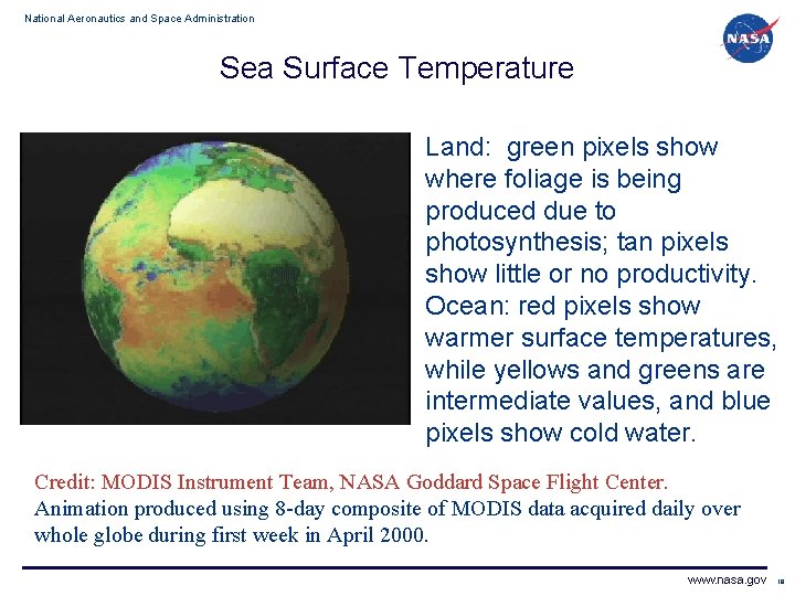
National Aeronautics and Space Administration Sea Surface Temperature Land: green pixels show where foliage is being produced due to photosynthesis; tan pixels show little or no productivity. Ocean: red pixels show warmer surface temperatures, while yellows and greens are intermediate values, and blue pixels show cold water. Credit: MODIS Instrument Team, NASA Goddard Space Flight Center. Animation produced using 8 -day composite of MODIS data acquired daily over whole globe during first week in April 2000. www. nasa. gov 19

National Aeronautics and Space Administration Notable Efforts in this Area • Committee on Earth Observation Satellites (CEOS) – Ad hoc Disaster Management Support Group (DMSG) – http: //www. ceos. org/pages/DMSG/index. html – Produced report, “The Use of Earth Observing Satellites for Hazard Support: Assessments & Scenarios”, 2002 available online • International Conference on Early Warning – Third International Conference on Early Warning against natural hazards will take place in Bonn from 27 -29 March 2006 – http: //www. ewc 3. org/ www. nasa. gov 20

National Aeronautics and Space Administration Current NASA Efforts in this Area • Space Frequency Coordination Group (SFCG) – Resolution A 25 -1 “Intersessional Working Group on Disaster Management (IWG-DM)” – http: //sfcgonline. org/handbook/res/RES_A 25 -1. pdf • International Telecommunication Union – Development Sector (ITU-D) – New Question /2: “Examination of ICTs and active and passive space-based sensing systems as they apply to disaster prediction, detection and mitigation” (Note: NASA is the tentative Rapporteur, to be affirmed at ITU-D SG 2 September 2006) – Expected ITU-D Reports: • Survey of active and passive space-based sensing systems and applications related to disaster prediction, detection, and mitigation. (actual work to be done by the SFCG IWG-DM) • Analysis of sensor applications for their utility by the ITU-D administrations. • Report providing options for dissemination of disaster related sensing products. www. nasa. gov 21

National Aeronautics and Space Administration Current NASA Efforts in this Area • What makes these new efforts different than what is being done elsewhere or before? ? ? – The ITU-D Reports will have greater visibility among the developing countries. – The ITU publication will provide a degree of authority not afforded by other efforts – Publication through the ITU will provide a mechanism for future revisions to the material. • Next Steps – Meeting of the SFCG IWG-DM at the International Geoscience and Remote Sensing Symposium (IGARSS) http: //www. igarss 06. com/index. html • Denver, USA 30 July 2006 – ITU-D Study Group 2 meeting • Geneva, Switzerland September 2006 www. nasa. gov 22

National Aeronautics and Space Administration Contact for Further Information Thomas von. Deak NASA Spectrum Management Office +1 (216) 433 3277 Thomas. C. von. Deak@nasa. gov (Provide e-mail to the above for intermediate outputs of efforts) www. nasa. gov 23