MiddleLatitude Cyclones I RECAP Types of Fronts Cold


 cyclone")
 cyclone A: the polar front")

 cyclone • • • D: Mature cyclone (initial")


cyclones:")
- Slides: 19
Middle-Latitude Cyclones - I
• • • RECAP: Types of Fronts Cold fronts: cold, dry stable air is replacing warm, moist unstable air. Moves fast, showers along the leading edge (squall line). Warm fonts: warm, moist unstable air is replacing cold dry stable air. Overrunning: warm air rides up and over the cold air, widespread cloudiness, light-to-moderate precipitation well ahead of the front Stationary fronts: essentially no movement, winds blow parallel to the front, in opposite directions on both sides Occluded fronts: when a cold front catches up with a warm front (more later) The symbols on a map are in the direction of the air mass motion.
• • • Stationary Front Stationary front- a front which does not move or barely moves. Stationary fronts behave like warm fronts, but are more quiescent. Many times the winds on both sides of a stationary front are parallel to the front and have opposite direction. Typically stationary fronts form when polar air masses are modified significantly so as to lose their character (e. g. , cold fronts which stall). Typically there is no strong precipitation associated with stationary fronts (why? – no big contrast in the air mass properties, no air uplifting and condensation).
• • • Occluded fronts. Cold fronts move faster than warm fronts. They can catch up and overtake their related warm front. When they do, an occluded front is formed. Cold occlusion: very cold air behind, not so cold air ahead of, the warm front The upper warm front follows the surface occluded front Cold occlusion
• • • Warm Occlusion Very cold air ahead of, not so cold air behind, the warm front The cooler air from the cold front cannot lift the very cold air ahead, rides “piggyback” The warm front aloft precedes the surface occluded front
• Weakening/Strengthening of the Frontolysis: ♦ The front weakens and dissipates ♦ Why? -the air masses start losing their identities. ♦ The temperature (humidity) contrast across the front is decreasing. ♦ Typical for slow moving fronts • Frontogenesis: ♦ The front intensifies. ♦ Why? – The temperature (humidity) contrast across the front is increasing. ♦ Example: c. P air mass moves over warm ocean water.
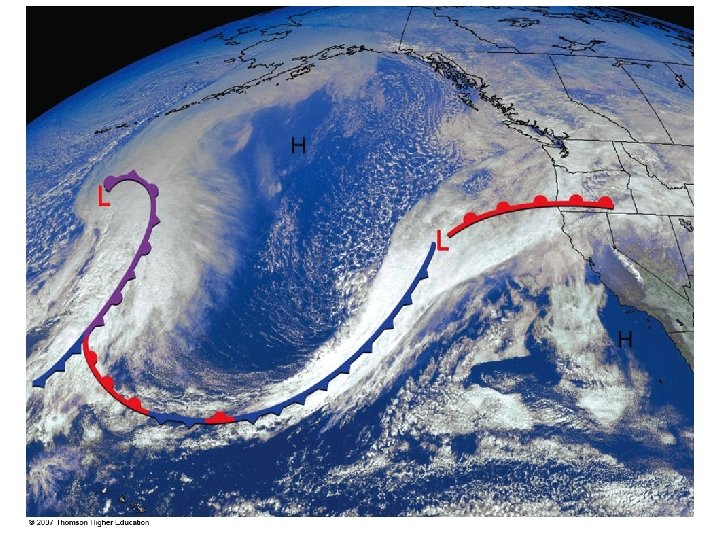
• • Weather Map Shown: surface-pressure systems, air masses, fronts, isobars, winds and air flow (large arrows) Green-shaded area: precipitation
• Weather Map The example from Chapter 1: Fig. 1. 14.
Sample weather maps
• • • Polar Front Theory A model of how mid-latitudes storms develop: their birth, growth, and decay. The model connects the storms with the dynamics of the polar front: the transition zone between the cold air in the polar cell and the warmer air at middle-latitude (Ferrel cell). The polar front is a region of air conversions at the surface, upward motion, and divergence aloft. This results in low surface pressure. Vilhelm Bjerknes Jacob Bjerknes + Halvor Solberg + Tor Bergeron
The life of a mid-latitude (wave) cyclone
• • The life of a mid-latitude (wave) cyclone A: the polar front is stationary: the winds are in opposite directions on the two sides of the front. This creates a cyclonic wind shear. B: A local perturbation: a region of low pressure appears somewhere along the front. The front then breaks in two fronts: ♦ warm (moving northward - why? Coriolis force) ♦ cold (moving southward - why? Coriolis force) ♦ Central pressure: the junction of the two fronts A frontal wave is formed. ♦ The winds aloft set the general direction of motion (black arrow) ♦ The wave starts moving to the east and gradually becomes C: Open wave. The cold front moves faster than the warm front -> polar front bends. Warm sector between the two fronts. The central pressure keeps dropping: isobars now encircle it.
• Weather patterns around a cyclonic wave South of the wave: ♦ First a warm front Warmer air advancing Wide band of precipitation. Starts with snow first. Then rain and drizzle. ♦ Cold front Cold air advancing Sharp drop of pressure Strong precipitation at the front. Then dry, cold, clear weather. North of the wave: some clouds associated with the low pressure center but no strong precipitation because there is no warm moist air around. • • •
The life of a mid-latitude (wave) cyclone • • • D: Mature cyclone (initial occlusion). Cold front closes in on the warm front. Most intense stage of the storm. Clouds cover a large area. E: Advanced occlusion. Triple point: where all three fronts come together. The center of the storm gradually dissipates: ♦ Cold air on both sides of the occluded front ♦ Warm sector far removed – the rising warm and moist air provides energy for the storm (kinetic energy, latent heat of condensation) F: Cut-off cyclone plus a stationary front once again.
Family of cyclones Dying out E: Advanced occlusion C: Open wave Just forming B: Frontal wave
• • Cyclogenesis Any development or strengthening of a mid-latitude cyclone Some regions have greater propensity for cyclogenesis: ♦ Gulf of Mexico ♦ Eastern slopes of Rockies and Sierra Nevada Lee-side lows ♦ Atlantic ocean east of Carolinas Nor’easters • • Lee cyclogenesis
Famous nor’easters: the Great Blizzard of 2006 • • • Began on Feb 11 2006 Developed an “eye” All-time record snowfall (27 in) in New York City.
• • Where do mid-latitude cyclones form? Typical paths of winter mid-latitude (anti)cyclones: ♦ Lows: towards the east-northeast ♦ Highs: towards the east-southeast Explosive cyclogenesis (bomb): when the central pressure drops very rapidly (more than 24 mb in 24 hours)