Hydrosphere Hydrological Cycle Hydrosphere There are 4 spheres


- Slides: 18
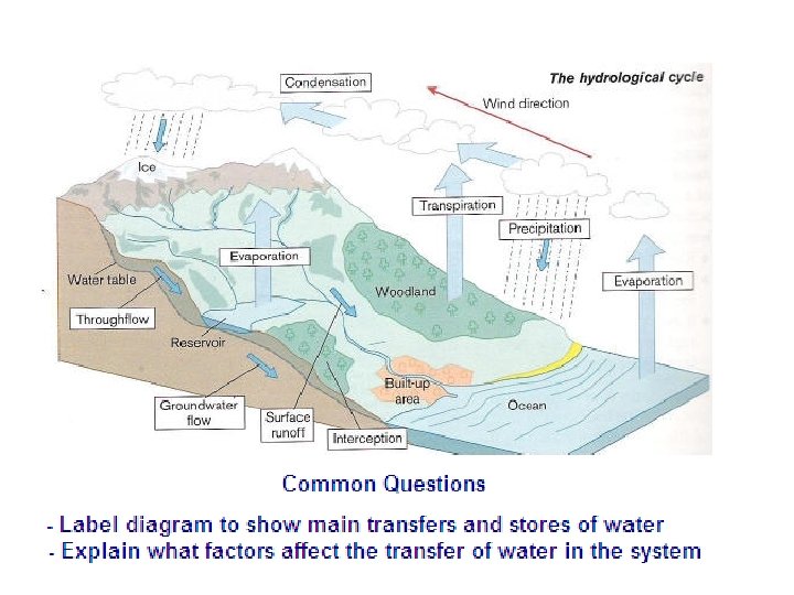
Hydrosphere Hydrological Cycle
Hydrosphere There are 4 “spheres” in Earth Sciences Atmosphere Biosphere Lithosphere Hydrosphere
Definitions
Definitions. . more • The hydrological cycle or water cycle is the continuous movement of water between the land, the sea and the air.
Another description of water flow
Drainage Basins • Rivers begin in upland areas and flow downhill, becoming deeper and wider until they reach the sea. Opposite is a typical diagram of a drainage basin and it shows its main feature. An open system
The main features • Source - The beginning of the River • Confluence - Where two rivers meet • Watershed - An area of high land between two drainage basins • Mouth - Where a river flows into a lake or the sea • Tributary - A small river or stream that flows into a larger river • Drainage Basin - The area drained by a river and its tributaries
Erosion: River bed & Banks • Hydraulic Action - This is where the force of the water wears away the bed and banks of a river • Abrasion or Corrasion - This is where rocks and pebbles that are carried along by the river mechanically erode the banks and bed of a river • Attrition - The rocks and pebbles that are transported by a river knock together and become smaller, more rounded and smoother the further down a river you go • • Solution or Corrosion - The water can dissolve rocks such as limestone and this is transported as a solution
How a River Transports its load
Common Questions • Locate features on diagram of river • Explain the main ways rivers erode • Explain how rivers transport material
Hydrographs
Hydrographs
Key Terms • • • peak rainfall peak discharge lag time base flow rising limb run-off ground soil water falling limb The run-off/discharge of the river is measured in cumecs - this stands for cubic metres per second. Precipitation is measured in mm.
This river flooded after the second rainstorm, when the discharge reached 75 cumecs, although the first rainstorm had more precipitation. Why?
River Features • You are expected to be able to describe and explain the formation of various river features: types of erosion: • Upper attrition, corrasion, • Middle corrosion and • Lower hydraulic action.
Definitions • Slower areas are found in deeper parts of the river filled with fine sediments and are called pools. • Faster areas are found in shallower parts of the river around larger stones and are called riffles.
Diagrams types of transportation the river can do traction, saltation, suspension and solution.