Contaminant DataDriven Simulations or How Polluted Can Your


 u What is the terrain like in that")


 Problem INPUTS PHYSICAL PROCESS OUTPUTS MEASUREMENTS INPUTS MATHEMATICAL MODEL OUTPUTS u. Determine")
 ) = 0")


 object of interest at time ti conditioned by")
 Dt u = div(a (x,")
: We use the sensor data, if")


- Slides: 21
Contaminant Data-Driven Simulations or How Polluted Can Your Simulation Become over Time Craig C. Douglas University of Wyoming http: //www. dddas. org Martin Cole, Yalchin Efendiev, Richard Ewing, Victor Ginting, Chris Johnson, Greg Jones, Raytcho Lazarov, Deng Li, Jenny Simpson, and Dobrev Veselin Joint project of the University of Kentucky, Texas A&M, and the University of Utah Supported in part by the National Science Foundation
Bioremediation Strategies INJECTION RECOVERY MACROSCALE GROWTH MECHANISMS MICROSCALE FLOW Attachment Detachment Reproduction Adsorption Desorption Filtration Interaction MESOSCALE INPUT Substrate Suspended Cells Oxygen
Forward versus Backwards in Time u Forward – Standard pollutant tracking problem in some sense – Start by knowing who is the polluter and where it began u Backward – Might not know who the polluter is or where it began – Determine it correctly u. Report it so remediation can be started u. Get sued u. Spend 5 -10 years dealing with lawyers – Virtual telemetry solves legal problems until software used in the field by others who are used to lawsuits
Data to Drive Application u Where is the contaminant? – Use remote sensing data to locate media, update positions, and find new spread directions. u. Open water bodies u. Buoys and/or submerged stations u. Chemical sensors u. Visible, near IR, and IR scanning u. Radiation detection u. Underground u. Well sensors
Data to Drive Application (cont. ) u What is the terrain like in that area? What small-scale features are there? – New topography sets give world topography at 30 arcsec (~ 1 km), US at 3 arcsec (~100 m). – Better local sources usually available from fire and police departments. u What are the changing weather conditions? – Large-scale data (current analyses or forecasts) used for initial conditions and for updating boundary conditions. u People as data sources and decision makers. – Hot spots, scales, subproblems, recombining subproblems, …
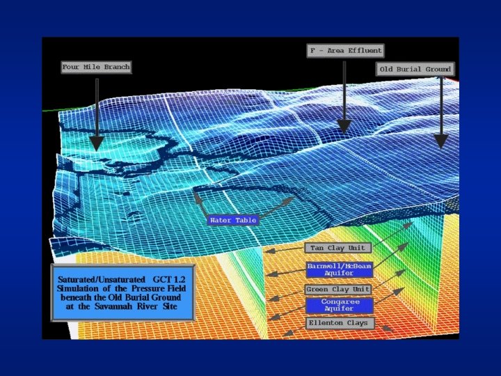
Savannah River Site u Difficult topography u Highly Heterogeneous Soils u Saturated and Unsaturated Flows u Reactions with disparate time scale u Transient/Mixed Boundary Conditions
Modeling Process PHYSICAL PROCESS PHYSICAL MODEL MATHEMATICAL MODEL OUTPUT VISUALIZATION DISCRETE MODEL NUMERICAL MODEL u Want everything to just work (just like the computers do on any Star Trek show/movie)
Identification (Inverse) Problem INPUTS PHYSICAL PROCESS OUTPUTS MEASUREMENTS INPUTS MATHEMATICAL MODEL OUTPUTS u. Determine suitable mathematical model u. Estimate parameters within mathematical model u. Long term simulations provide lots of data that can be used to approximate the solution to the
Issues of Perturbations from On-Line Data Inputs u Solve: F(x+ x(t) ) = 0 Choice of new F(x+ approximation for x – Do not need a precise solve of equation at each step u. Incomplete solves of a sequence of related models u. Effects of perturbations (either data or model) u. Convergence questions? – Premium on quick approximate direction choices u. Lower-rank updates u. Continuation methods – Interchanges between algorithms and simulations – Local boundaries and conditions not known a priori u Fault-tolerant algorithms
Many Different Components that We Want to Vary Quickly during Project u We need graphics, solvers, and specialized codes – SCIRun has great potential and will be used u. Open source and free u. Extensible since owners of code are project members u. Easy to construct complicated codes using cut and paste plus connect the boxes techniques – What our project has added to SCIRun u. General, mixed finite element basis functions u. Sensor input (virtual or real telemetry) u Completely Grid oriented: typically, sensors and (super)computers separated by great distances.
SCIRun Methodology
SCIRun and Telemetry u Streaming paradigm very useful – Add/delete remote clients trivially – Well understood for audio and somewhat less for video u Streaming implementations problematic for DDDAS – Typically too much/little data that comes out of order. – Need a data warehouse that cleans up data, stores it with an error estimate, and automatically contacts running appications that need the new data.
SCIRun and Telemetry u Adding streaming modules – Line points to a stream, either incoming or outgoing, instead of another SCIRun module – IP addresses may change over time and need to be tracked by a server u Fill in data (interpolation as needed) as data comes in u Timestamp data so that running backwards in time possible and reverting to an earlier time step (warm restart) is possible (locally or globally)
Why Interpolation Is Required u Data available only at subset of mesh points or elements u Data might not be available on mesh at all u Multiscale interpolation useful or required
Sensor Data Insertion u C (ti|Mi) object of interest at time ti conditioned by data Mi. Sensor data from subset of nodes of a coarse triangulation. Geostatistical information filters the updates.
Nonlinear parabolic case u General equation of form (1) Dt u = div(a (x, t, u , Dxu )) + a 0, (x, t, u , Dxu ), in Q 0 [0, T], where Q 0 is the spatial domain and represents small hetereogenieties. u Sh space of piecewise linears on coarse mesh. u We construct mapping E: Sh Vh, by constructing mapping that satisfies in K [ti, ti+1], K a coarse element, (2) Dt u , h(x, t) = div(a (x, t, , u , Dxu , h)) where is the average of u u , h(x, t) and is the solution of (2) on the fine scale mesh.
Multiscale Comparison Method u Boundary conditions in (2): We use the sensor data, if available, or the last known data otherwise. In some cases we cannot fix the values since this would cause artificial discontinuities in the solution of (2). u We compare data at sensor locations using u Coarse mesh used for most of the computation, making the method very effective.
Why Virtual Telemetry? u We are doing contaminant tracking. Suppose you have real telemetry data to offer us… – Would you really admit you are a significant polluter? – Do you want the extent of your pollution known? u Oil simulation experts in academia rarely have access to long term actual data from reservoirs. The data is usually sanitized and only for starting simulations from simple datasets. u It is hard to beat the cost of virtual telemetry. u We can vary quantity and quality of data using multiple streams.
Conclusions u Designing general purpose components that will be useful by DDDAS community. u Telemetry components inexpensive to set up and use. – Transparent when switching between real and virtual telemetry and now integrated into SCIRun. – Allows us to investigate easily DDDAS aspects that are not in static data set formulations. u Inexpensive multiscale methods were developed for interpolation problems. u Dissemination through http: //www. dddas. org – Links to other projects there, too.