Community Geodetic Model Jessica Murray David Sandwell and


- Slides: 25

Community Geodetic Model Jessica Murray, David Sandwell, and Rowena Lohman June 1, 2014

The Community Geodetic Model Motivation: Spatially and temporally dense time series of ongoing deformation utilizing the complimentary features of GPS and In. SAR data are expected to be central to several SCEC 4 core initiatives and science targets. The continued expansion of GPS coverage, launch of new SAR satellites, recent advances in In. SAR time series analysis, and ongoing advances in noise assessment and mitigation can be leveraged in order to develop methodology for generating a combined GPS/In. SAR time series product.

Some target applications for the CGM: • Quantifying slip rates and strain rates and their spatial variations in the complexly-faulted southern California region, including off-fault strain • Assessing non-tectonic time-varying signals without aliasing • Detecting transient deformation and tracking its space/time evolution at sufficient precision to relate it to other processes such as seismicity • Constraining lithospheric rheology and evaluating its role in earthquake cycle deformation • Characterizing postseismic deformation and the underlying physical processes • Providing input to develop or refine stress and stressing rate models and/or to validate candidate stressing rate models for the Community Stress Model Different applications require different spatial and temporal data coverage and resolution; GPS and In. SAR can complement each other.

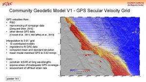
Available Data: GPS and EDM Figure: Duncan Agnew

Available Data: SAR Comprehensive time series ERS & Envisat 1992 - 2011 11, 000 Sentinel start ~2014 7000 1400 2000 4000 Ascending ALOS velocity field, but limited temporal resolution 1700 Few targeted time series studies possible with COSMO-Sky. Med & Terra. SAR X (Currently sparse and costly) 11 -day repeat 800 Scott Baker, Roland Burgmann 1 -to-8 -day repeat

In. SAR to Support CGM - News • • Sentinel-1 A (ESA) was successfully April 3, 2014, SAR collecting data! – C-band , 12 -day repeat; provides continuity with ERS and ENVISAT – Mostly Scan. SAR coverage of the SAF, ascending and descending – Completely open data access – finally!! – Sentinel-1 B to be launched 2016 and will provide 6 -day repeat interval ALOS-2 (JAXA) was successfully launched May 24, 2014, antenna deployed – L-band, 14 -day repeat – Mostly Scan. SAR coverage of the SAF, ascending and descending – PI proposal needed for data access – Limited quantities per PI – Perhaps SCEC should work with DPRI for improved access for SCEC research • NISAR (NASA) was approved for phase A funding May 7, 2014 – L and S-band, 12 -day repeat, launch 2020 – Mostly Scan. SAR coverage of the SAF, ascending and descending – NASA-ISRO SAR Mission Applications Workshop, USGS, October 28 -29, 2014

CGM Workshop: May 30 – 31, 2013, Menlo Park • 29 participants including experts in GPS and In. SAR as well as representatives of the CSM, Ductile Rheology, Transient Detection, and UCERF 3 efforts • Established what CGM will comprise: Will include campaign and continuous GPS, any available In. SAR data Three basic categories: GPS-only, In. SAR-only, combined product Raw time series: GPS 3 D, In. SAR LOS Derived quantities: secular rates, offsets, outliers, postseismic decay terms, seasonal models, noise parameters, common mode filter parameters, In. SAR coseismic displacement fields • Combined product will not be interpolated to a uniform grid; will be more dense near faults (in part driven by availability of GPS sites which are used to constraint In. SAR) • Two working groups formed: GPS and In. SAR • •

Next Steps – 2014 activities • Additional data gathering, comparisons, and method development are needed for both the GPS and In. SAR components before we can begin merging them • GPS action items: • Gather all SGPS data and metadata • Collect more campaign data if appropriate • Compare different processed solutions; reconcile discrepancies • Merge campaign and continuous processed results (reprocess if needed) • Decide best strategy for modeling noise, postseismic, seasonal and apply • In. SAR action items: • In. SAR time series analysis test exercise to establish best practices • Reach out to broader In. SAR community, including international, as appropriate • Both: • Develop strategy and framework for combining GPS and In. SAR time series to produce a joint data product including covariance information

Funded CGM-related GPS work (2014) • Additional field campaign data collection • Floyd & Funning: GPS sites where older data in archives can be leveraged to improve spatial coverage of velocity field • Fialko: Coyote Creek fault and San Felipe shear zone cross-fault profile • Mc. Gill: Resurvey new (2013) San Gorgonio Pass sites and part of the San Bernardino Mtn. network • Agnew, Floyd, Herring, Shen: Compile campaign GPS data and metadata, especially to identify previously unused data and to verify metadata; leverage CMM infrastructure • Floyd, Hammond, Herring, Owen, Shen: Combine processed solutions for multiple GPS networks; process/reprocess if necessary to produce time series; compare results from different solutions • Floyd, Herring, Shen, Group: Identify and implement best approach for merging GPS time series results to form the GPS component of the CGM • Segall: Assessment of GPS time series noise and its impact on velocities

Fialko M&B F Funning and Floyd Mc. Gill and Bennett

Big-picture In. SAR goals (SCEC and WIn. SAR) • Develop integrated GPS/In. SAR deformation models (SCEC CGM) at 200 m spatial resolution and better than seasonal temporal resolution. • Work with ESA to ensure SCEC science targets are included in Sentinel-1 acquisition plan. (Currently land surface monitoring is only 5 th highest priority. ) • SCEC and DPRI should approach JAXA on ALOS-2 data sharing agreement. ALOS-2 top priority is disaster monitoring. • Promote a NASA L-band mission to provide data later in decade. • Continue to develop open-source software tools for automated processing of the new Scan. SAR data streams.

Variety of vertical deformation sources to consider Santa Fe Springs, CA Oil wells Average LOS velocity, In. SAR time series Pomona, CA Ground water pumping San Jacinto Fault, Tectonic signal Simons and Agram

Example: Earlier work highlighted Santa Ana aquifer signal Lanari et al. , 2004

Detailed study with more data and new methods is ongoing • Jun 1992 – Sep 2010 • 105 ERS images + 60 Envisat images. • 881 interferograms • Acquisitions almost every month for 18 years. • Monthly acquisitions allow study of seasonal signal in detail. From Piyush Agram

In. SAR illuminates deformation on short spatial scales Seasonal Amplitude Seasonal Phase Amplitude of signal appears “smooth” while phase has sharp boundaries Simons and Agram

In. SAR time series also reveal temporal patterns Full scale Reduced color scale range • Time lag (days) of seasonal amplitude compared to location with maximum seasonal amplitude (*) • Spatial variation related to differences in in lateral conductivity and may be distance-dependent Simons and Agram

In. SAR time series test exercise • First “real data” In. SAR time series comparison • Quantitatively Identify agreement among In. SAR time series solutions and between In. SAR and GPS; will consider • Anticipated participants Agram Lohman Baker Shirzaei Funning Tong (PI Sandwell) Liu Tymofyeyeva (PI Fialko) • – “flattening” of interferograms with/without GPS – unwrapping errors in rough terrain – tradeoffs between atmospheric signals and real temporal variations Dataset: 2 frames – Desert, mountains, urban – Low strain areas + regions with known anthropogenic signals – Dense GPS site coverage Targeted outputs – Gridded map of LOS secular velocities – Time series at selected GPS sites – Time series at unknown, non-GPS sites

In. SAR time series test exercise • Phase I (2013) – Inter-group comparison limited by differences in choice of interferograms, spatial scale – Comparison of In. SAR results with velocities of individual GPS stations problematic – Intra-group comparisons focused on effect of atmospheric models • Anticipated participants Agram Lohman Baker Shirzaei Funning Tong (PI Sandwell) Liu Tymofyeyeva (PI Fialko) Phase II (2014) – Participants will use the same set of interferograms and the same spatial scale. – Coordination telecons in June and August; comparison of results at September 2014 workshop

September 2014 CGM workshop • GPS topics • Review data compilation to identify remaining gaps in data or metadata • Compare processed GPS time series to identify and resolve discrepancies • Decide upon strategy for merging GPS solutions into single time series dataset; consider choice of reference frame • Identify most appropriate approach for time series analysis and noise characterization to estimate derived quantities • In. SAR topics • Inter-group comparison of In. SAR time series analysis test exercise results • Select best practices for producing In. SAR time series for CGM • Overall CGM topics • Outline strategy for producing joint GPS-In. SAR time series data product, drawing upon findings and discussions of each working group • Set specific action items and schedule; consider group proposal for 2015

For more information Workshop webpage: http: //www. scec. org/workshops/2013/cgm/index. html Workshop report: Murray, J. , R. Lohman and D. Sandwell (2013), Combining GPS and Remotely Sensed Data to Characterize Time-Varying Crustal Motion, Eos Trans. AGU, 94(35), 309. Wiki: http: //collaborate. scec. org/cgm Mailing lists: http: //mailman. scec. org/mailman/listinfo/cgm (general postings) http: //mailman. scec. org/mailman/listinfo/cgm-g (for GPS focus-group) http: //mailman. scec. org/mailman/listinfo/cgm-i (for In. SAR focus-group) Contact information: Jessica Murray (jrmurray@usgs. gov) Rowena Lohman (rolohman@gmail. com) David Sandwell (dsandwell@ucsd. edu)


Americas – EWS and IWS, ascending orbits, 12 days A

Americas – EWS and IWS, descending orbits, 12 days A


CGM In. SAR Activity • Objectives – develop best high spatial resolution crustal deformation time series using In. SAR eventually augmented with GPS. • In. SAR group is refining test exercise begun in 2013 to compare In. SAR time series methodologies starting with the same interferograms. • In. SAR group plans to meet virtually to refine test exercise, set resolutions and deadlines. • Participants will assemble at the 2014 SCEC annual meeting to compare results. • All of this is preparation for accurate and frequent acquisitions to be provided by Sentinel-, ALOS-2 and eventually NI-SAR.
 Clare sandland
 Early help sandwell
 Mackenzie jean rowling murray
 State geodetic administration
 Ngs geodetic toolkit
 Teropong pendatar tangan
 Ggos
Ggos Canadian geodetic datum
 Federal geodetic control subcommittee
 Federal geodetic control subcommittee
 Ngs data explorer
 Federal geodetic control subcommittee
 Geodetic
 Lake murray resort and marina
 Bugs and bees murray ky
 Morton heilig biography
 Murray wilkinson
 Arnold murray alan turing
 Million dollar murray
 Need dan press dalam tat
 Dissolution of partnership accounting
 Mga pananaw sa pagsulat
 Murray johannsen
 Teoria de henry murray
 Jason murray bl
 Fr paul murray
